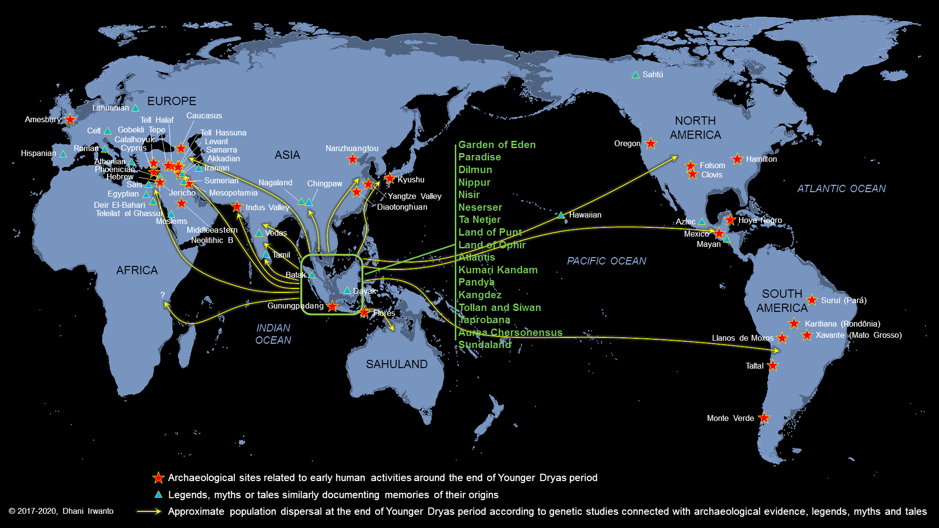
Plato’s tale of Atlantis, told in Timaeus and Critias, has fascinated readers for over two millennia. Yet Plato was not writing in a vacuum. Across the world, from India to Mesopotamia, from Egypt to Tamil traditions, we find stories that sound strangely familiar. These are not “proofs” of Atlantis, but parallels—echoes of catastrophe, paradise, or vanished lands.
Kumari Kandam (Tamil Memory of a Sunken Land)
The Tamil tradition speaks of Kumari Kandam, a lost landmass once ruled by the Pandyan kings. Ancient Tamil texts like Silappatikaram and Kaliththokai describe Sangam academies—gatherings of poets—some of which were said to have been drowned by the sea. Later Puranic texts placed Kumari Kandam in the deep south, now swallowed by the ocean.
It was imagined as a vast territory divided into 49 regions, crossed by mountains with 48 peaks, irrigated by channels from four great rivers. Mining of gems and gold was central. Eventually, the land was said to have been “swallowed by the sea” (Katalkol).
In modern times, revivalists fused this myth with the Victorian hypothesis of Lemuria, a now-abandoned scientific theory about a sunken Indian Ocean continent. Tamil nationalists embraced it as ancestral memory. In my earlier article on Lemuria, I showed how Kumari Kandam became conflated with Lemuria and even Mu, giving the myth a global spin.
Atlantis echo: A golden civilization, irrigated plains, gem mines, destroyed by rising seas.
Kangdez (Iranian Fortress-Paradise)
Iranian epic literature preserves the memory of Kangdez (Fortress of Kang). In the Shāhnāmeh and Bundahishn, Kangdez appears as a miraculous walled city in the Far East. Slides highlight its placement: “at the far eastern ocean, about six months to a year’s voyage from Iran, near the equator, outside China, east of India.”
Descriptions of Kangdez include concentric rings of walls layered with metals and precious stones, plentiful waters, eternal springs, and places of play, silver and gold towers, and a great plain influenced by the sea’s tides with rivers flowing south from volcano-studded mountains.
Atlantis echo: Both traditions emphasize concentric fortifications, gleaming metals, abundance of water, and a paradisal yet precarious geography.
Neserser (Egypt’s Island of Osiris)
In the Book of the Dead (Papyrus of Nu), we encounter Neserser—“the Island of Fire” in the far East, where the sun rises. It is the dwelling place of Osiris (Ausares, Asar) and Thoth. The imagery is vivid: Osiris enthroned in the center of six or seven concentric circles on a sacred lake, a volcanic-like “island and lake of fire” dedicated to Ra, floods that reshape the landscape, and Thoth residing nearby, keeper of divine knowledge.
Later Egyptologists described these circles as “hidden after the flood.”
Atlantis echo: Here again are concentric circles, a sacred island, a great flood, and divine kingship.
Mount Nisir (Mesopotamian Flood Memory)
The Epic of Gilgamesh recounts a great flood, where Utnapishtim builds an ark. After seven days, the boat grounds on Mount Nisir. Slides add color: the land in the Far East was like paradise, with forested mountains, rivers, vast plains, noisy birds, cicadas, and monkeys screaming in the trees.
This imagery is tropical—not the dry Mesopotamian steppe, but a lush, equatorial realm. Some scholars note that “Nisir” is phonetically close to “Neserser” and even “Nusasura.”
Atlantis echo: The flood, the grounding of survivors on a mountain, the paradise-like tropical plain.
The Asuras and the Ahuras
In early Vedic India, the Asuras were not evil—Varuna, guardian of cosmic law and the waters, was chief among them. Later texts, however, cast the Asuras as enemies of the Devas, while Varuna retained dignity as a god of oceans.
In Iranian religion, the cognate term Ahura (as in Ahura Mazda) was elevated as the supreme god, while the Daevas (same root as Devas) became demons.
India (early Vedas): Asuras = powerful lords, led by Varuna
India (later): Asuras = demons
Iran: Ahuras = good, Daevas = bad
Assyria: Ashur = supreme deity
Egypt: Osiris (Asar, Asari) = supreme deity with concentric-circle symbolism
Atlantis echo: The Atlantean kings were “Poseidon’s sons.” Poseidon parallels Varuna/Baruna, lord of seas and boundaries. The name “Atlas” recalls “Asura/Ashur/Osiris.” We glimpse a very old naming web that Solon may have repurposed.
“Atlas” and “Poseidon” as Borrowed Names
Plato openly said he borrowed names “to make the tale intelligible to his audience.” Thus Atlas and Poseidon may be Greek masks for older gods.
Atlas: The mountain-bearing Titan in Greek myth; but also linked to the root “Asura/Asar.”
Poseidon: God of seas and quakes, mirroring Varuna/Baruna/Vouruna—Indo-Iranian lords of waters and oaths.
These echoes suggest that Solon translated Near Eastern deities into Greek equivalents. The concentric rings, sacred kingship, and sea-lord all survive the translation.
The Garden of Eden
Finally, the Garden of Eden—a paradise watered by a river dividing into four: Tigris, Euphrates, Gihon, and Pishon. Genesis places Eden in the East, yet beyond ordinary geography. Some scholars argue Eden reflects older Mesopotamian “Dilmun” traditions—a far-off, pristine land. My 2015 article even suggested Kalimantan as Eden’s real-world counterpart.
Atlantis echo: Eden shares the archetype of a paradise lost—an ordered, fertile place destroyed or closed off after human transgression.
Gosong Gia and Nusantara Echoes
Slides mention Nusasura—possibly the “original name of Atlantis.” It combines nusa (island) and Asura. Old maps show names like Nusasira or Nisaira, perhaps distorted echoes. The Gosong Gia reef in the Java Sea is suggested as a drowned remnant. Even the people of Bawean Island hold myths of a sunken land.
Atlantis echo: If Atlantis lay in the Java Sea, Nusantara traditions like Nusasura may be its local survival in name.
Neserser, Punt, and Southeast Asia: The Egyptian Connection
Plato insists that his Atlantis story came from Egyptian priests at Sais, who told Solon the tale. If so, then the Egyptian worldview—their maps of trade, geography, and sacred memory—shaped what Plato inherited.
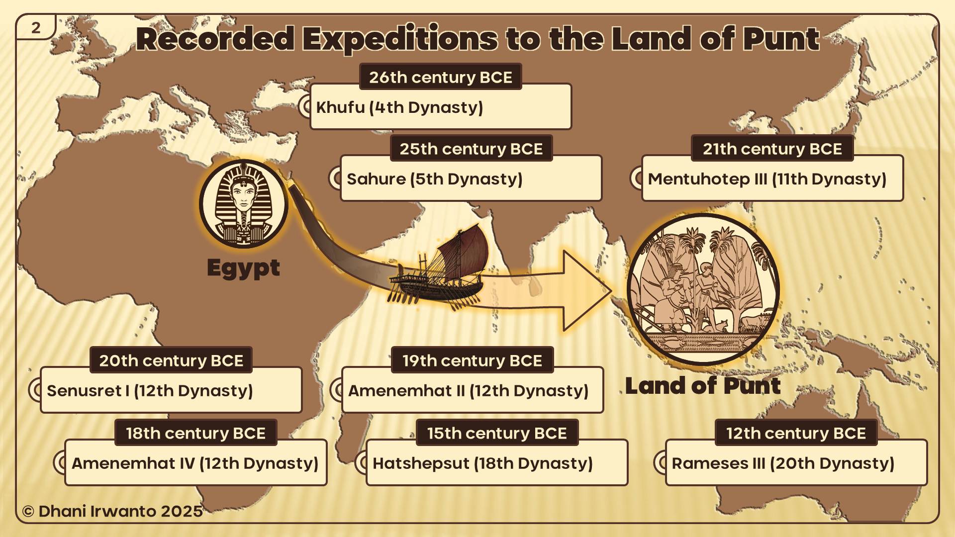
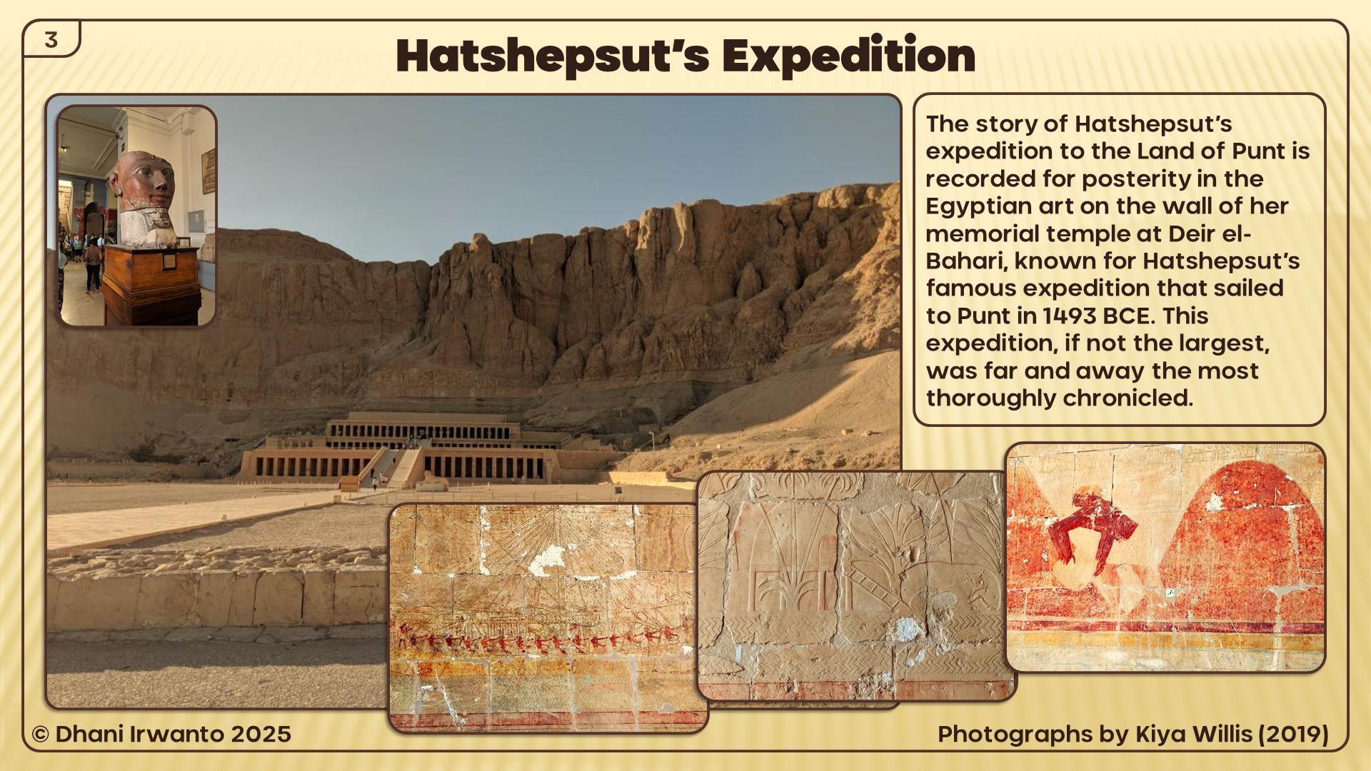
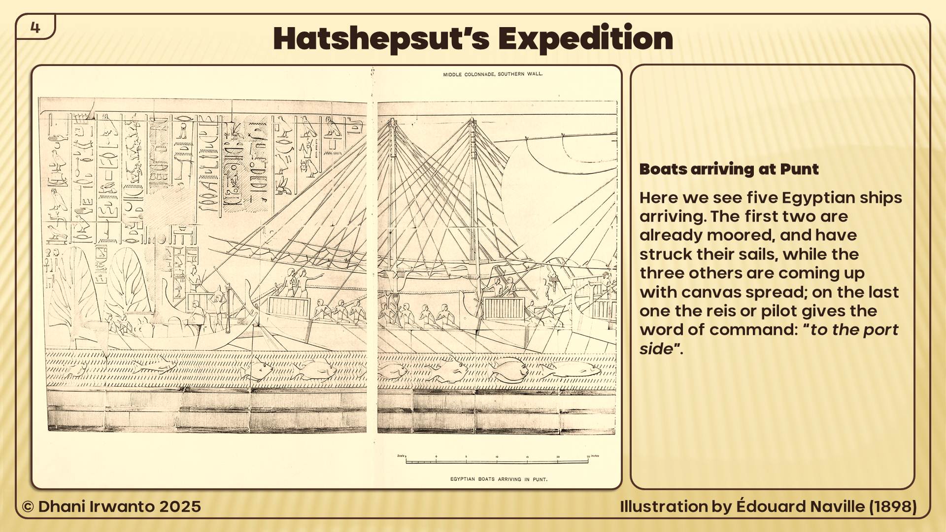
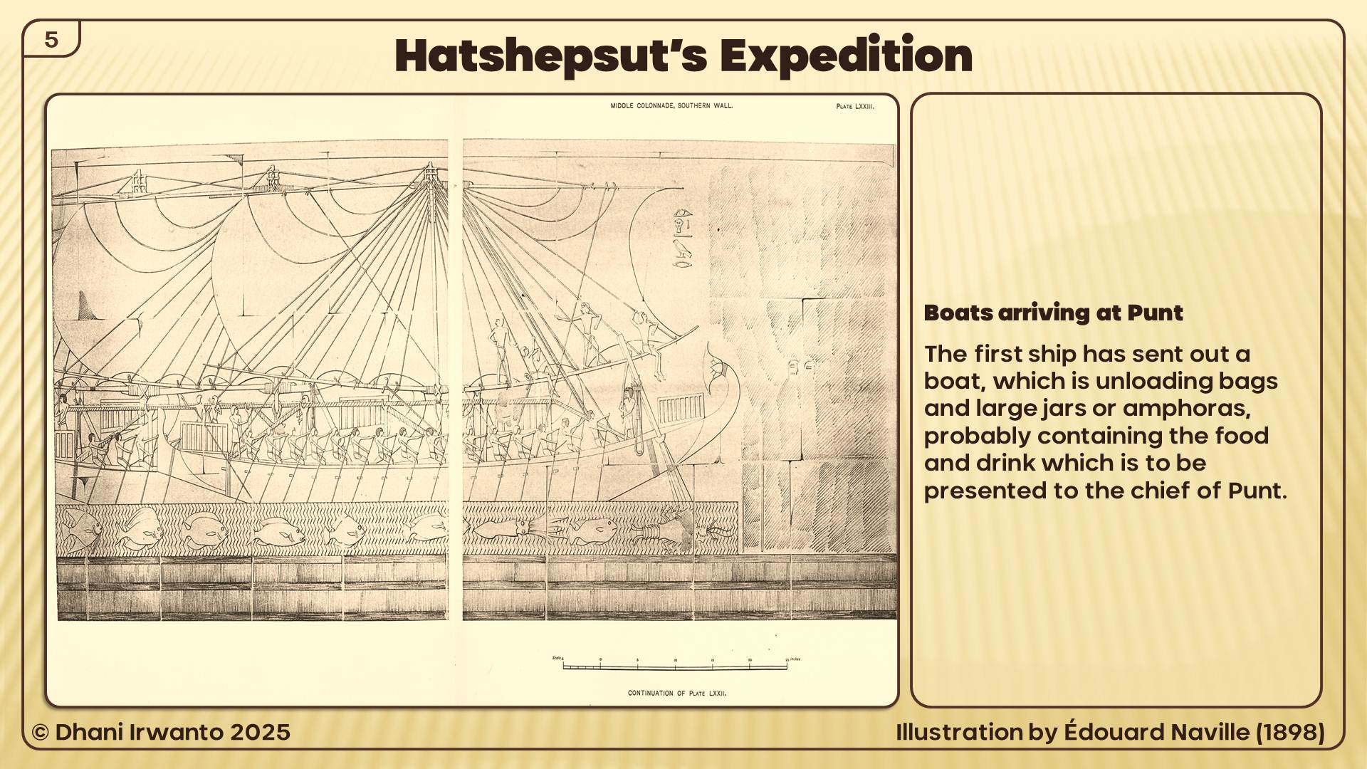
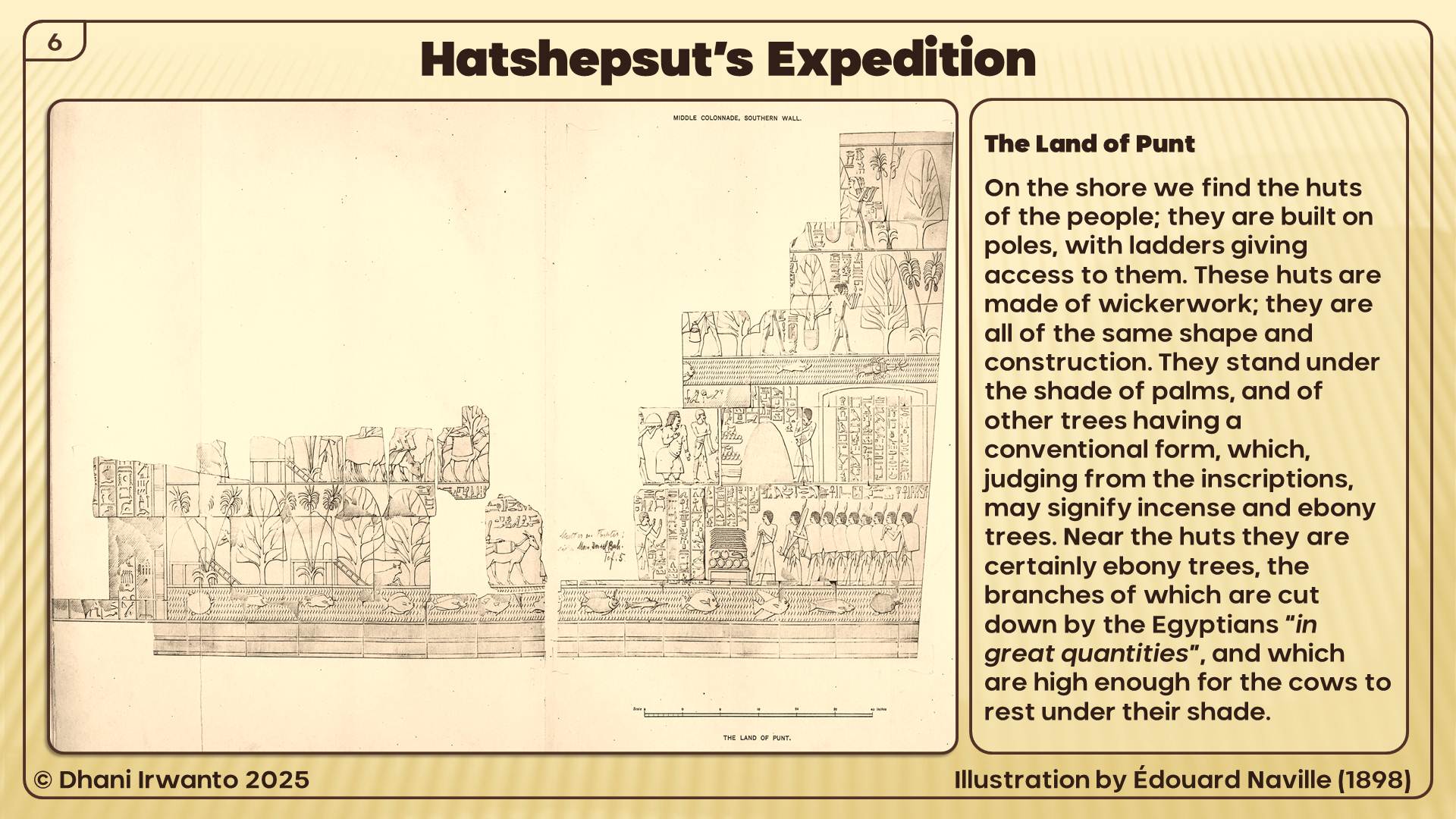
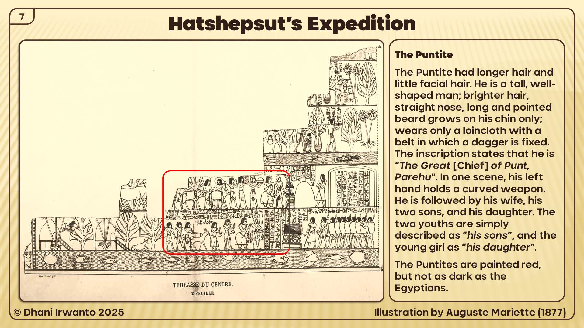
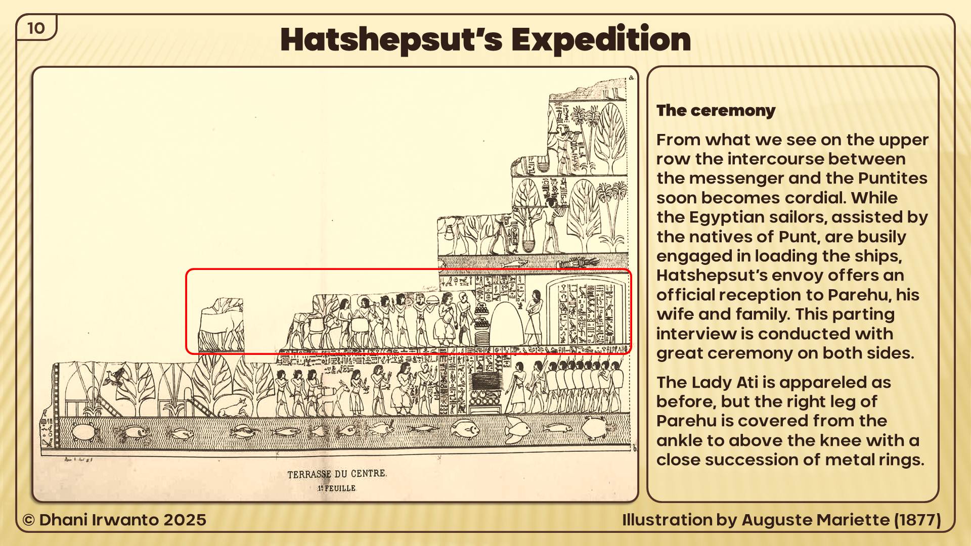
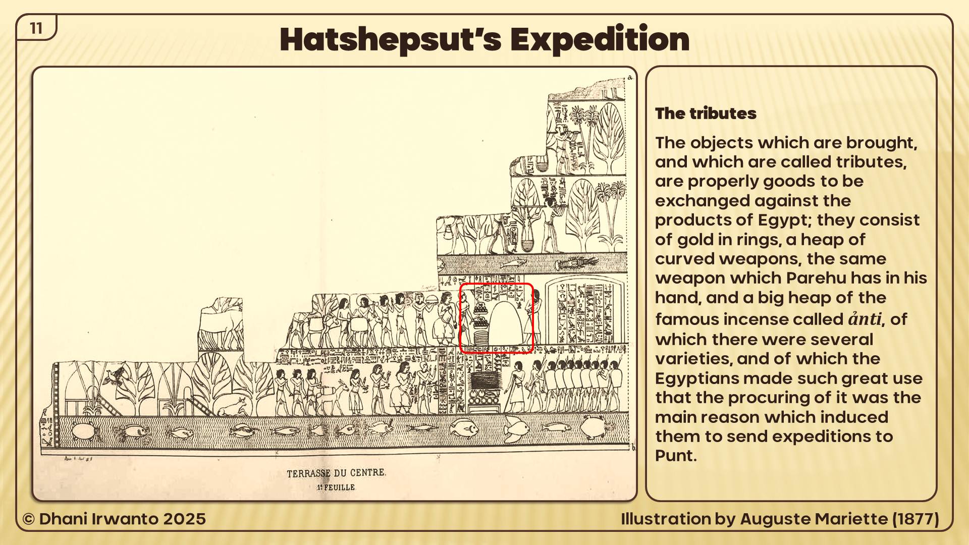
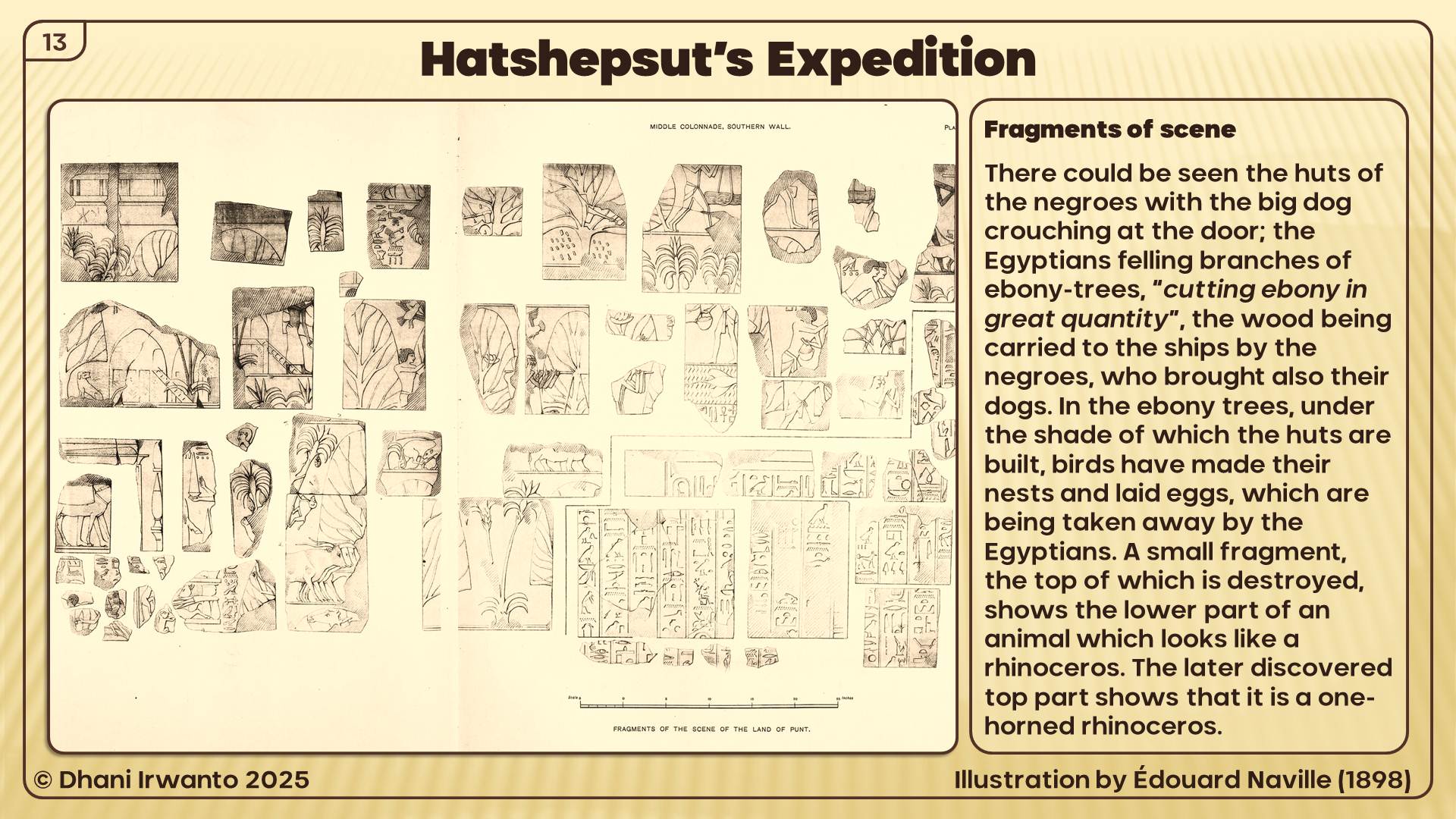
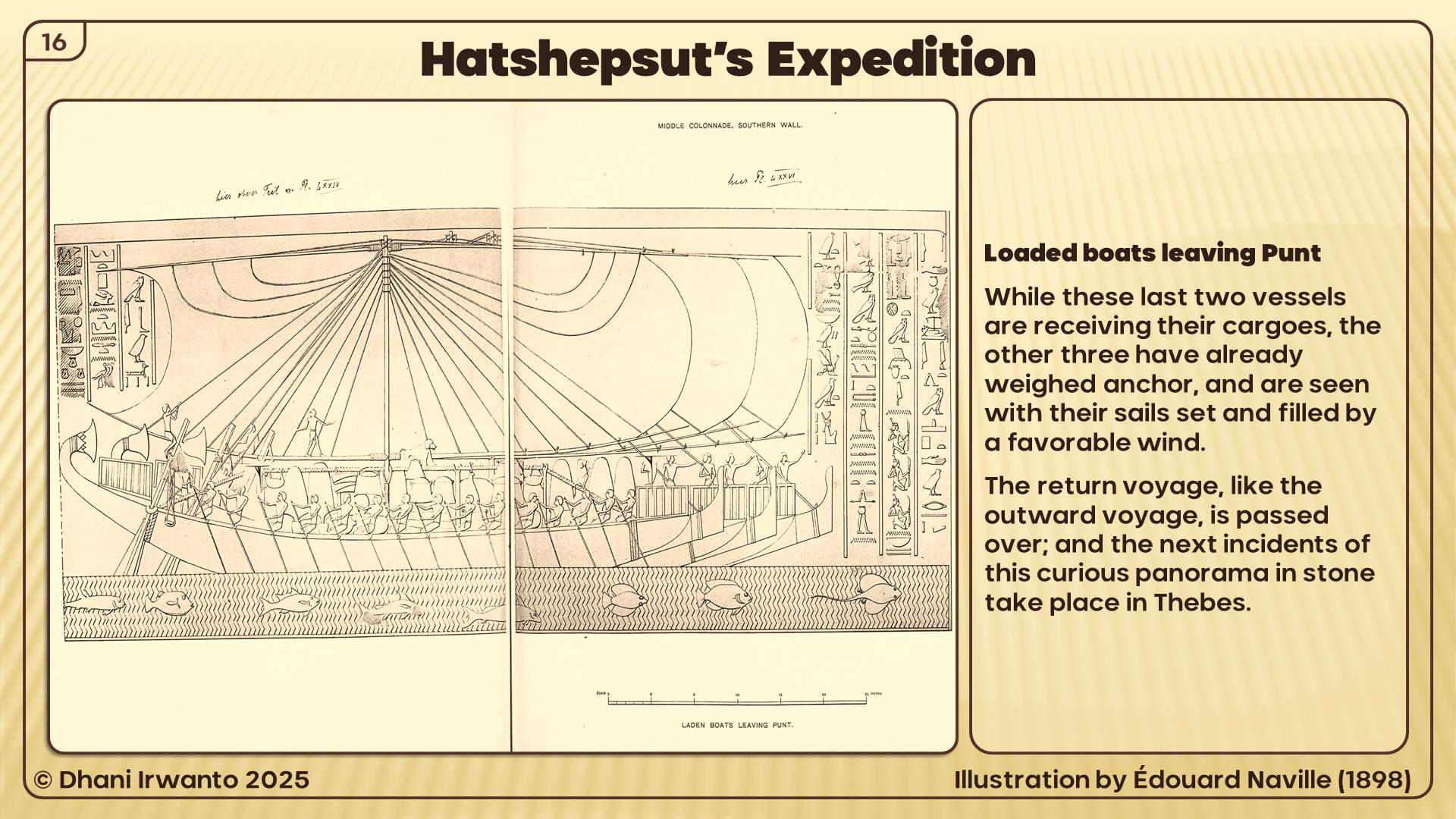
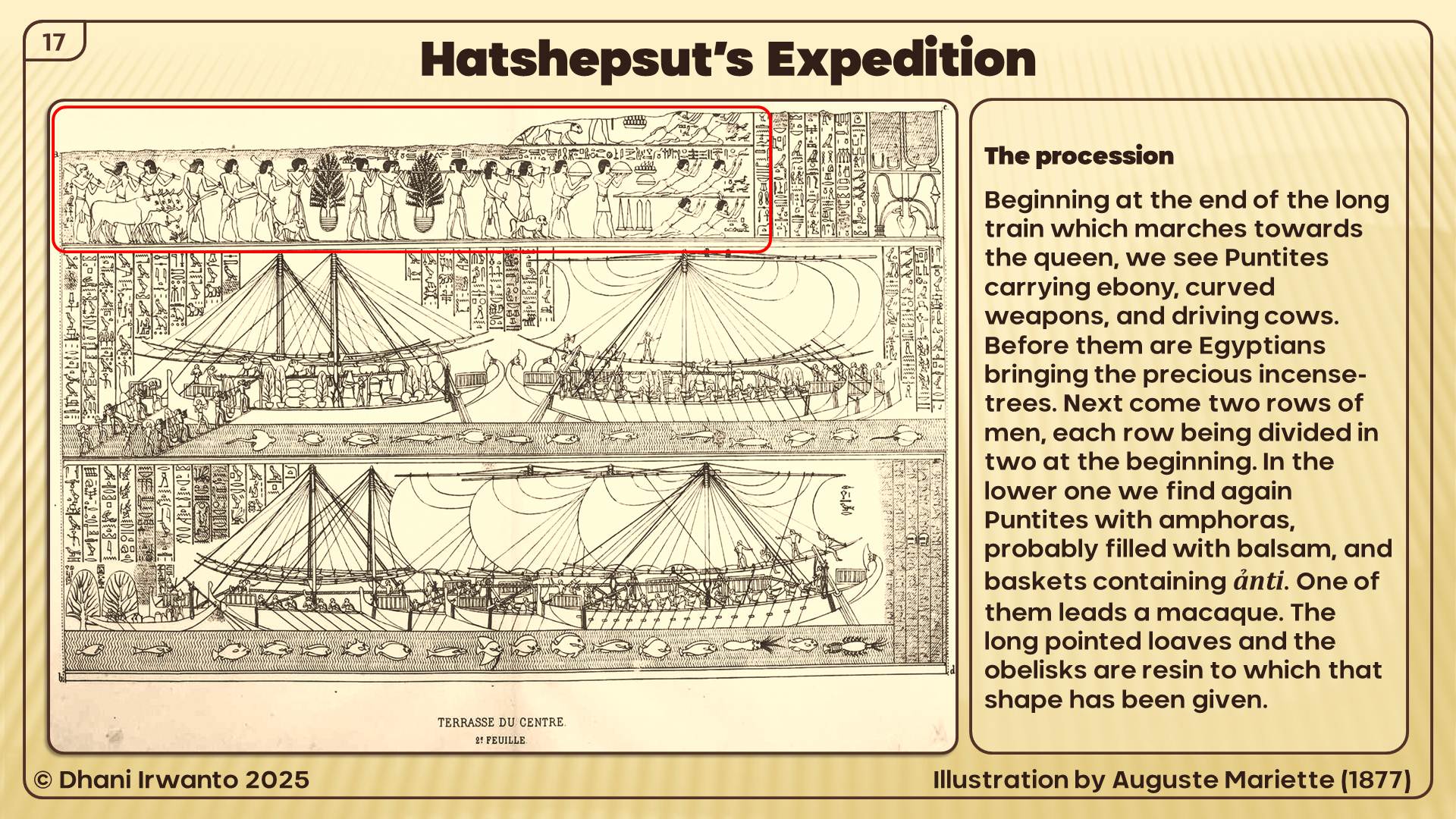
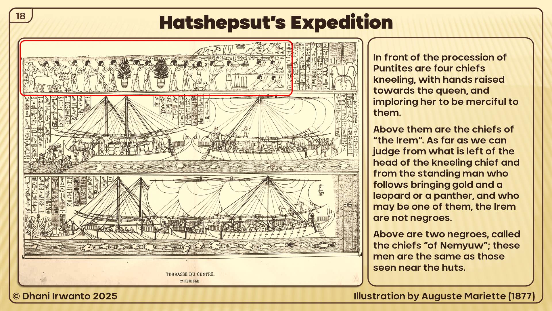
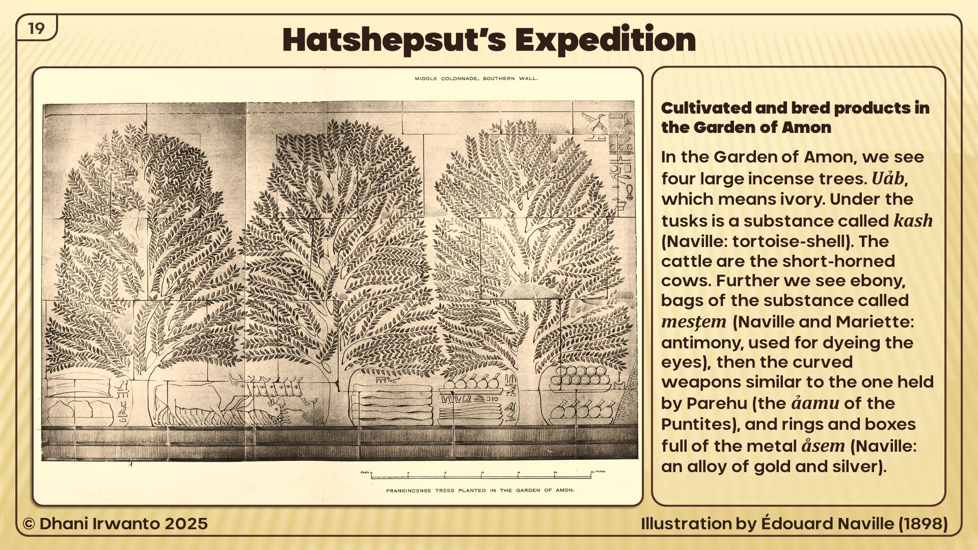
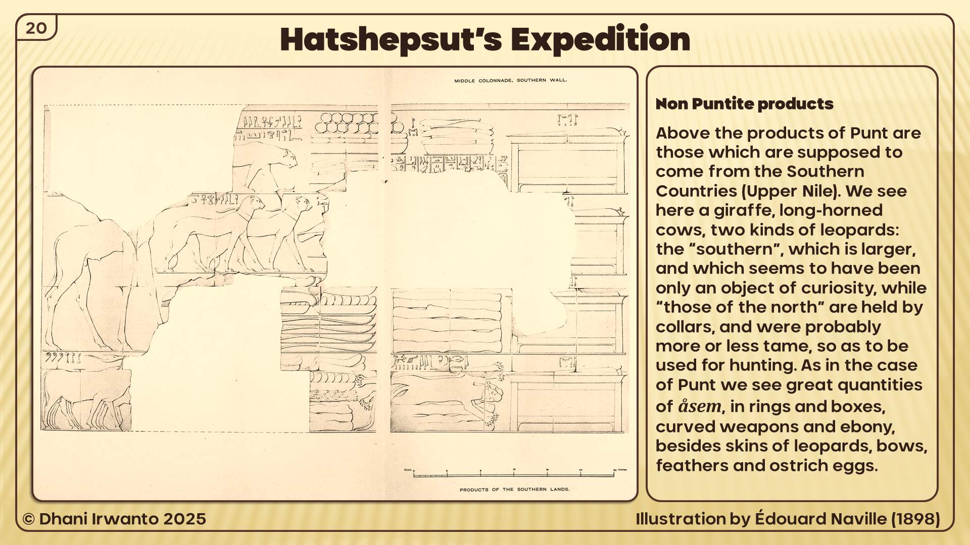
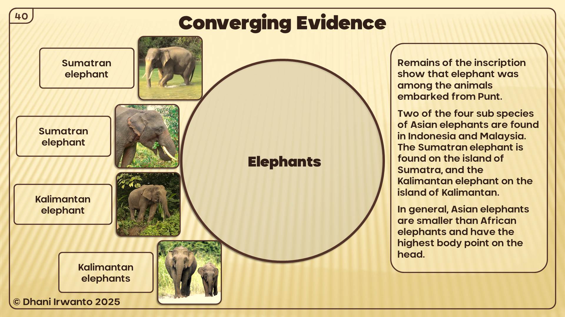
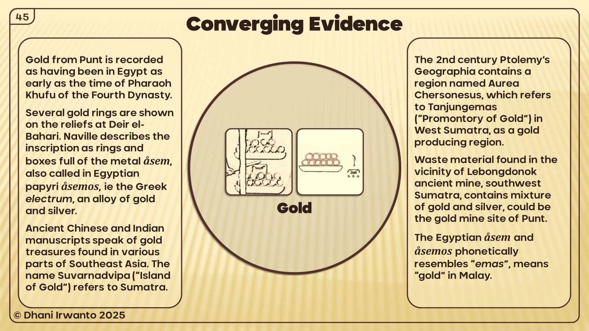
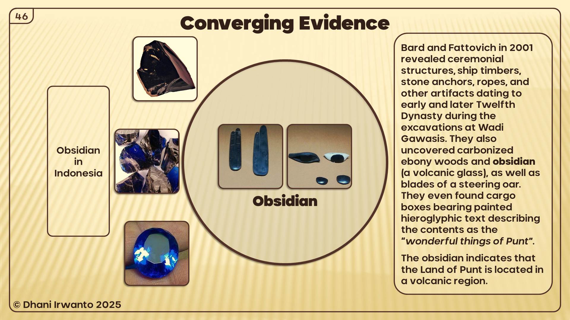
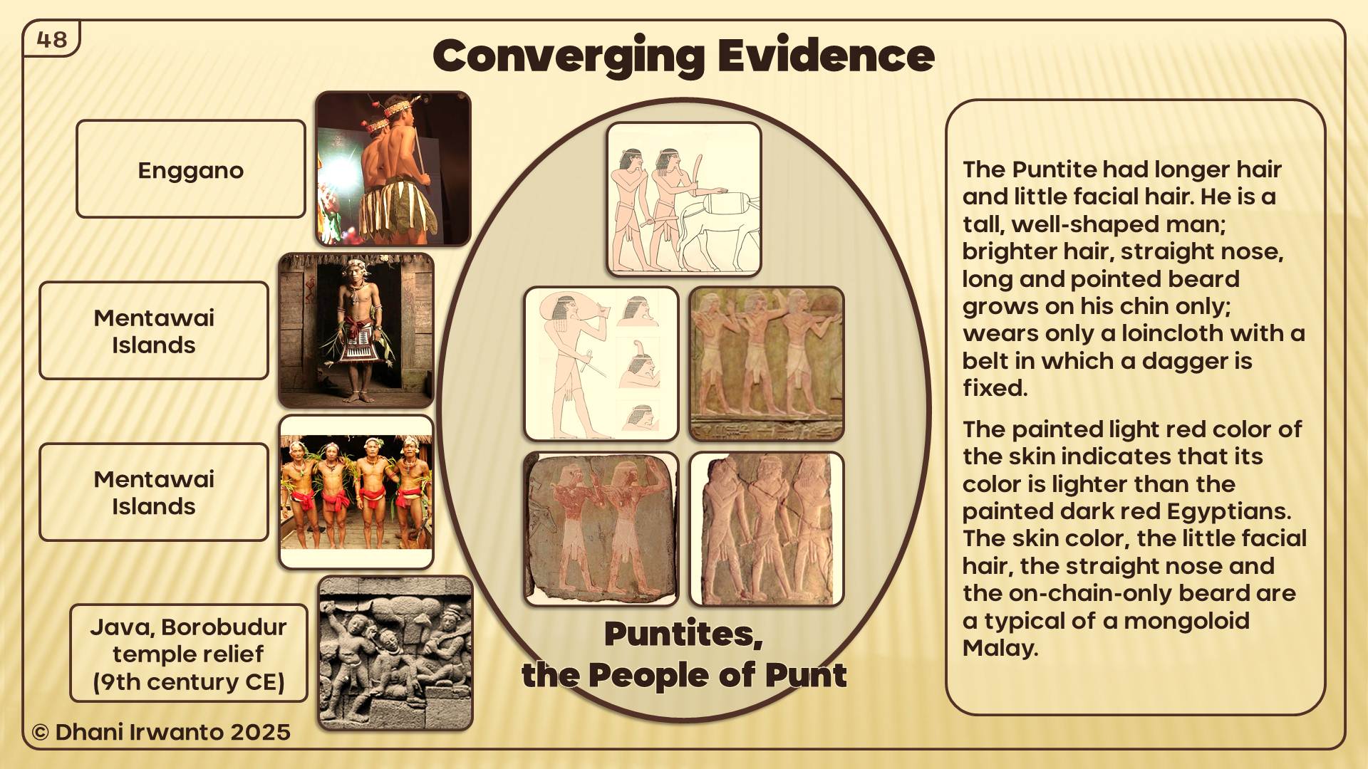
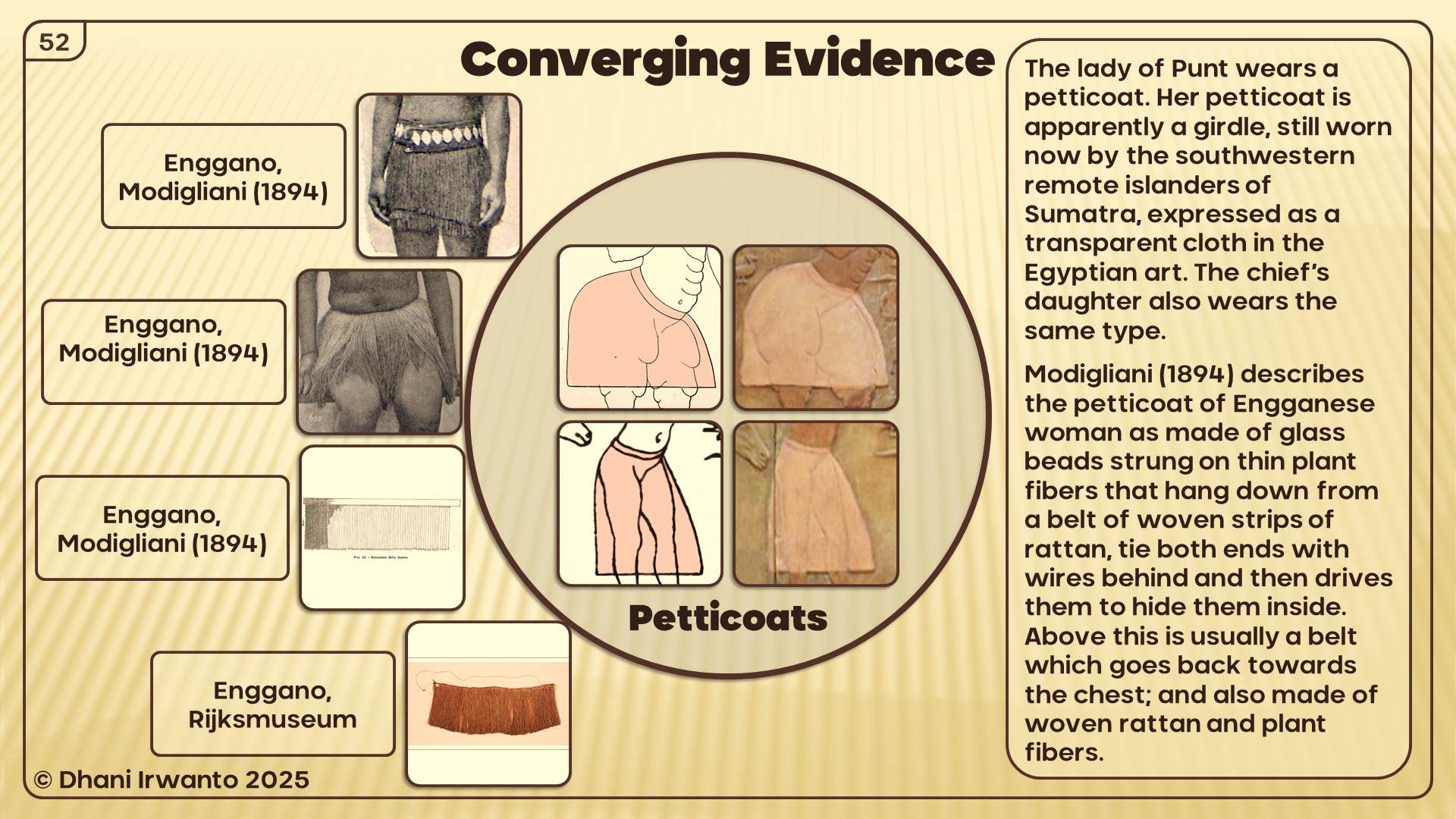
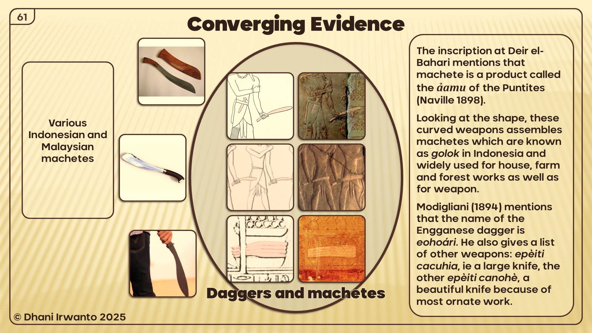
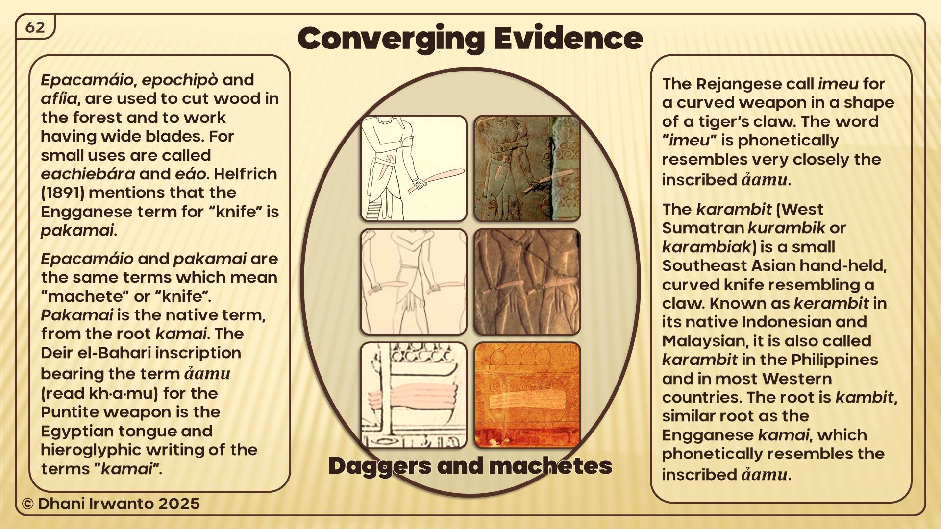
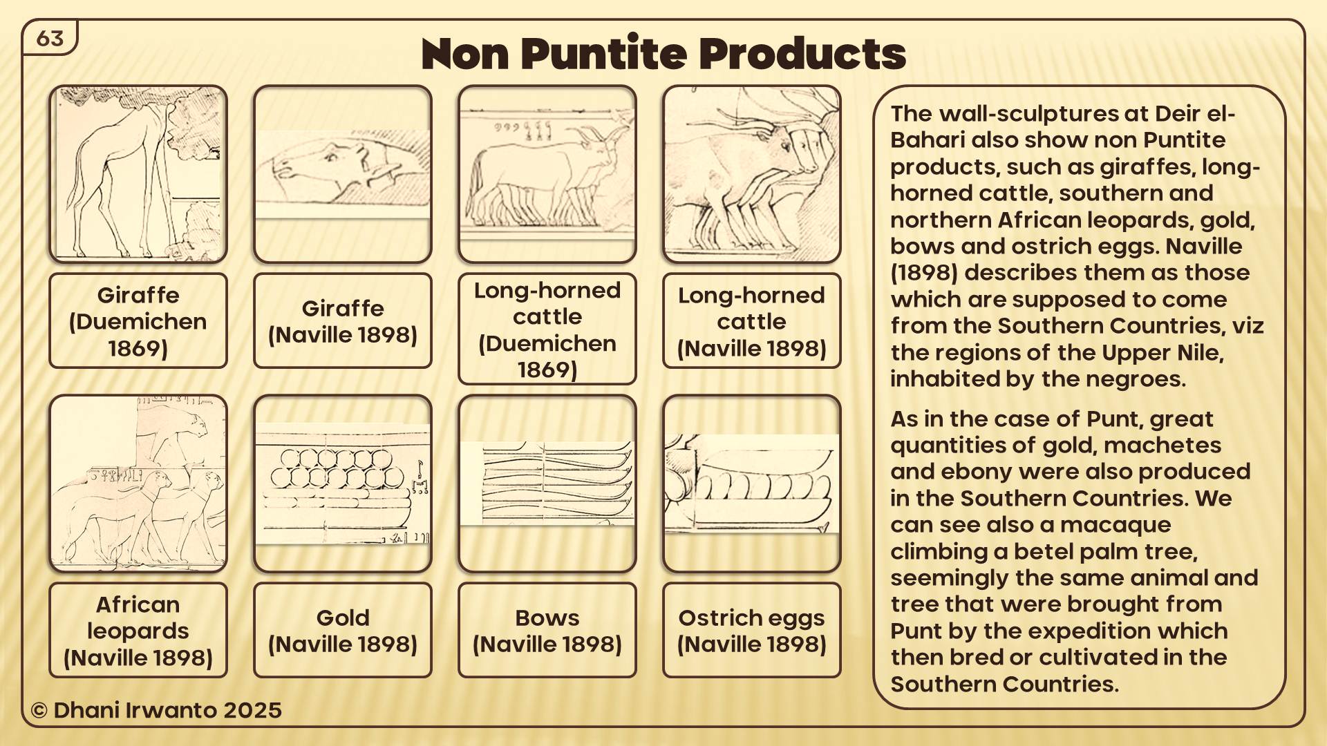
The Egyptians had firsthand knowledge of Southeast Asia, preserved in their accounts of the Land of Punt. Punt, described as the Ta Netjer or “land of the gods,” was not a vague myth but a real destination of repeated voyages, from Khufu to Rameses III. The great expedition of Hatshepsut (c. 1493 BCE) is famously carved on her temple walls, showing Egyptian ships sailing to Punt’s harbors.
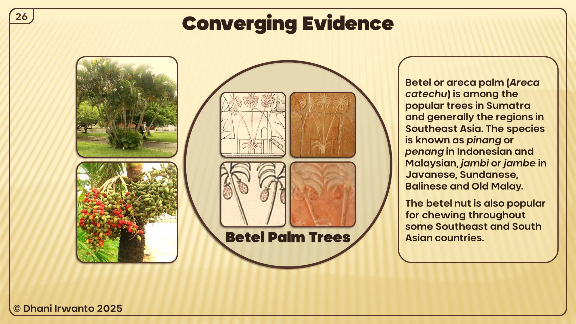
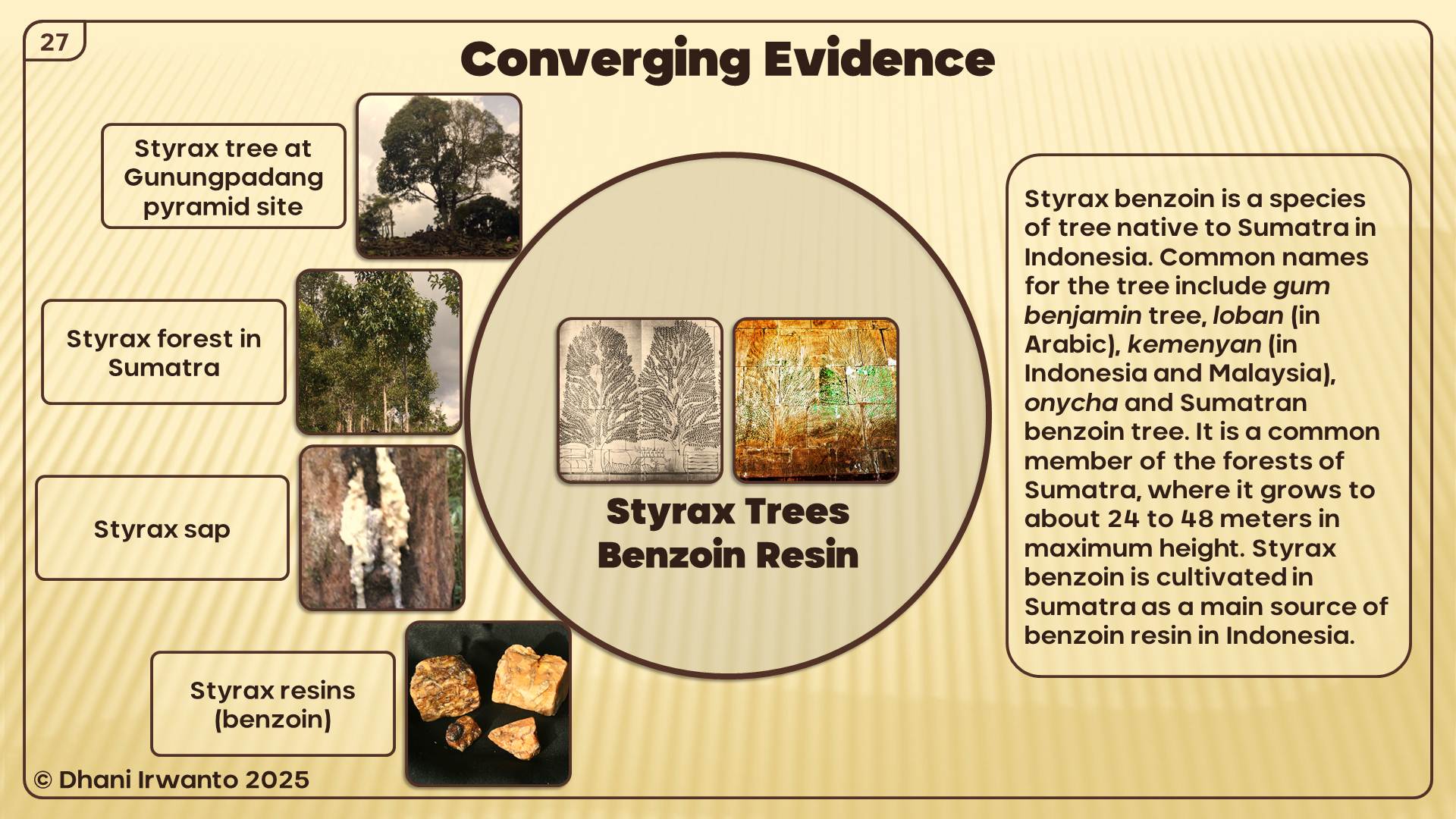
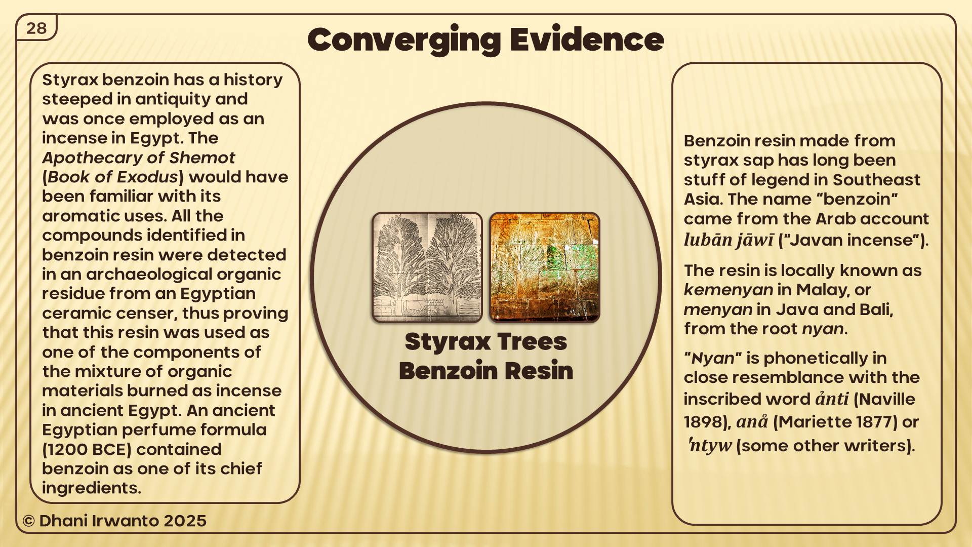
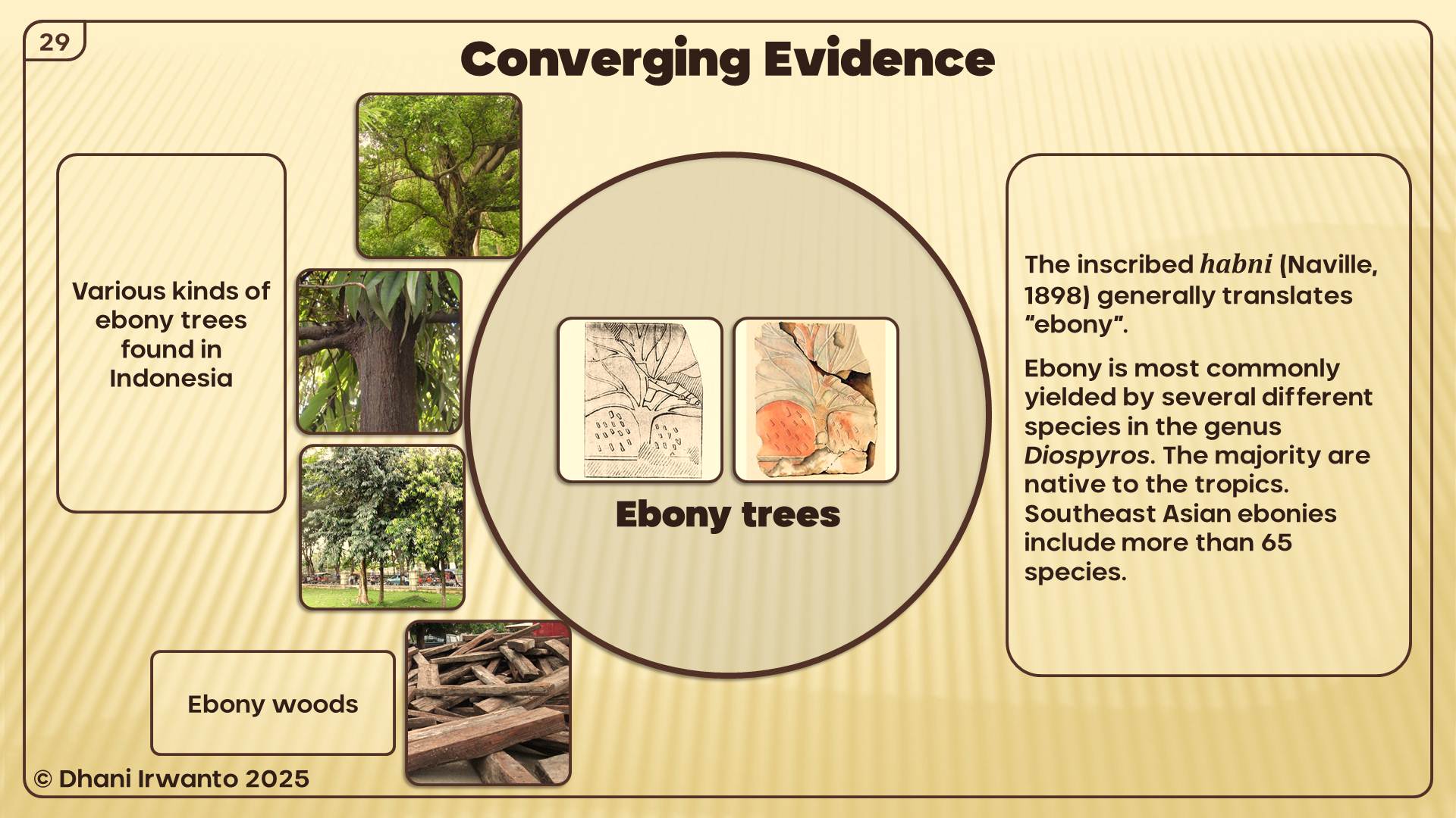
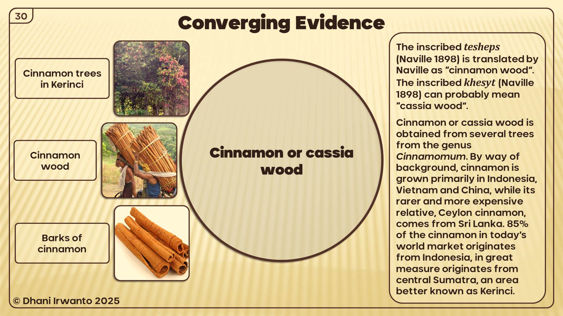
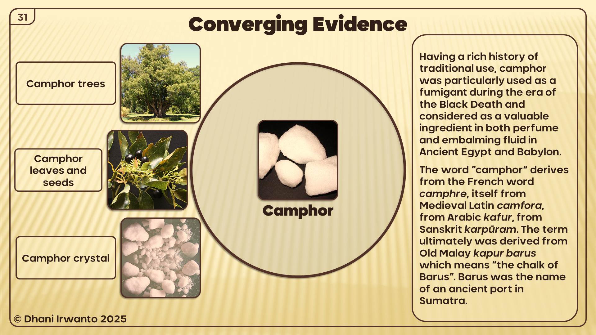
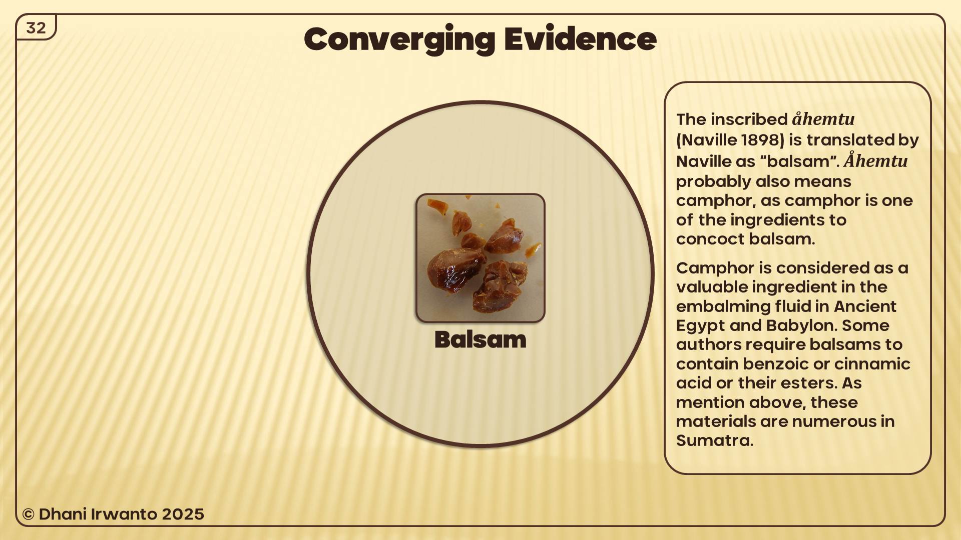
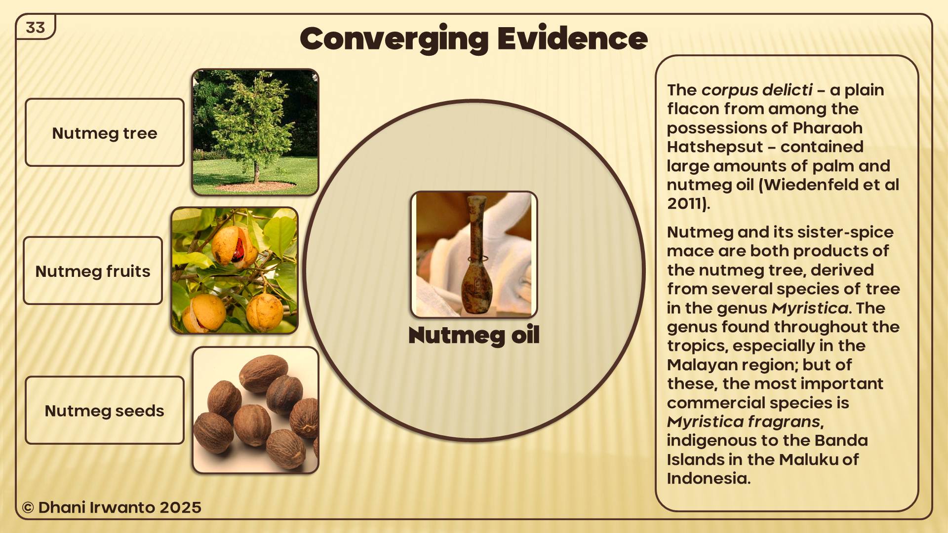
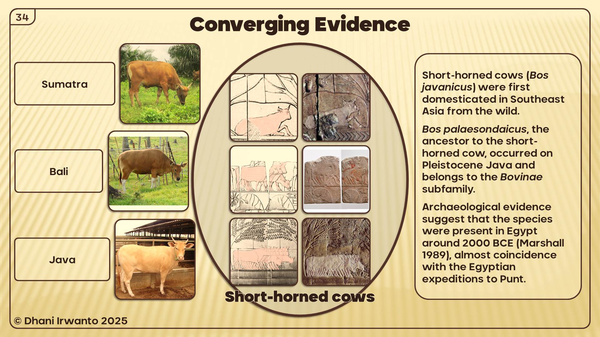
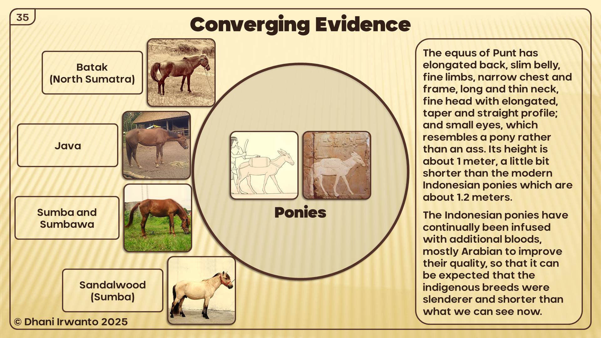
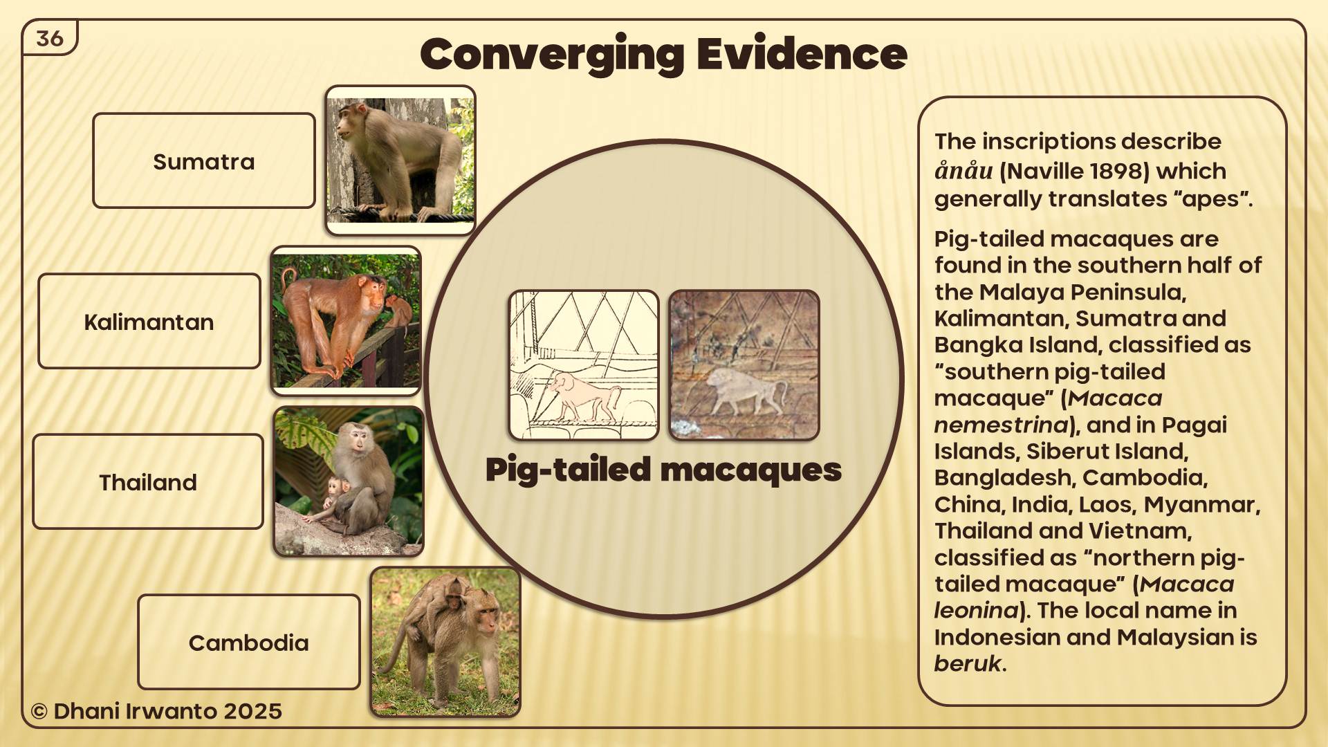
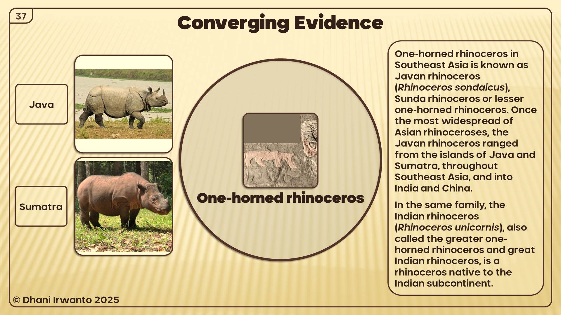
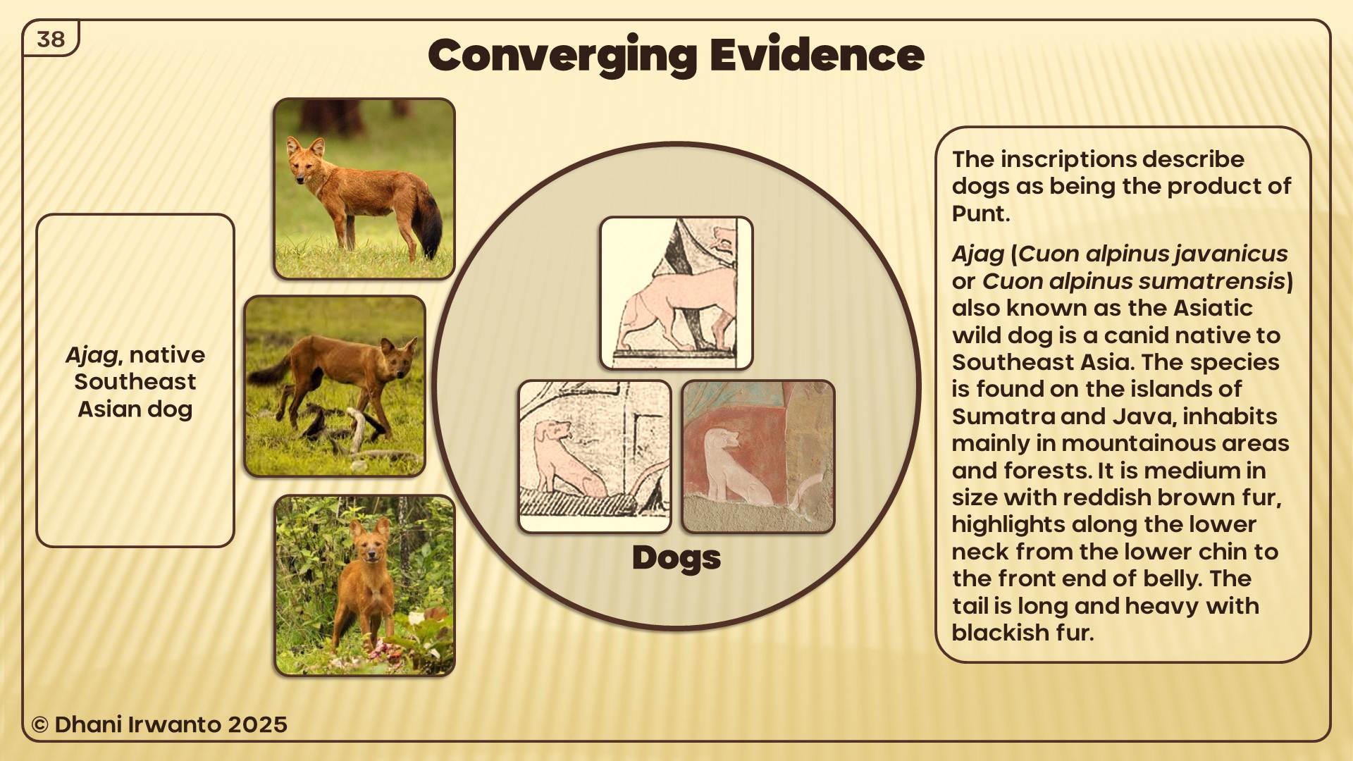
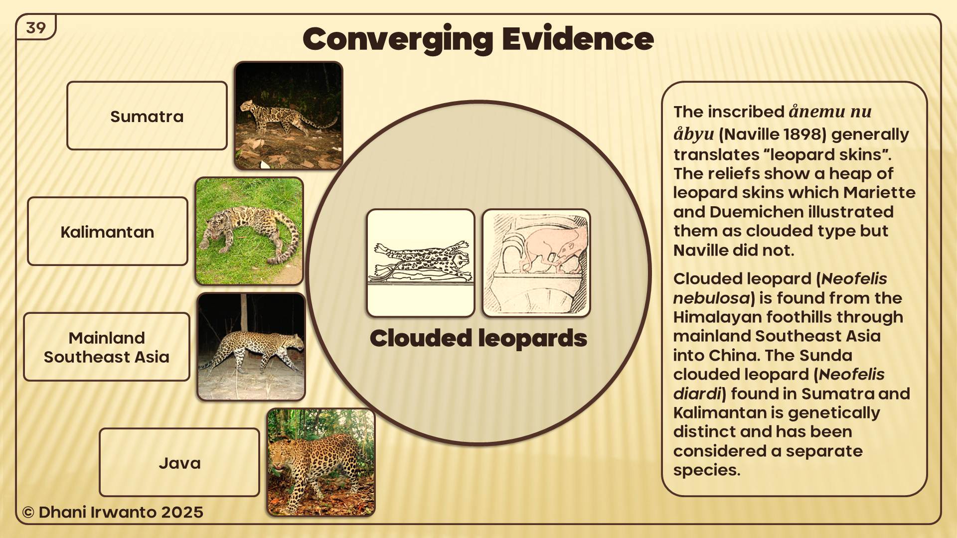
Products: Gold, camphor (kapur barus), benzoin (kemenyan), cinnamon, ebony, nutmeg, short-horned cows, elephants, and macaques—all endemic to Sumatra and neighboring islands.
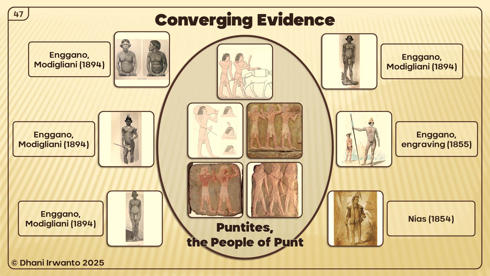
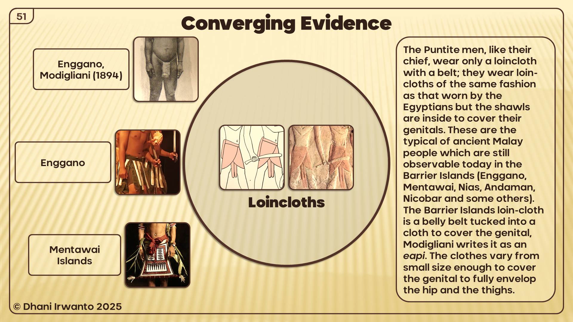
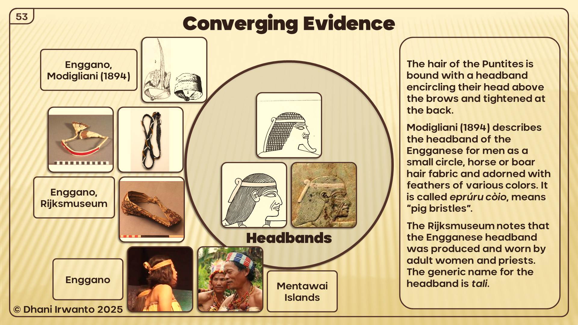
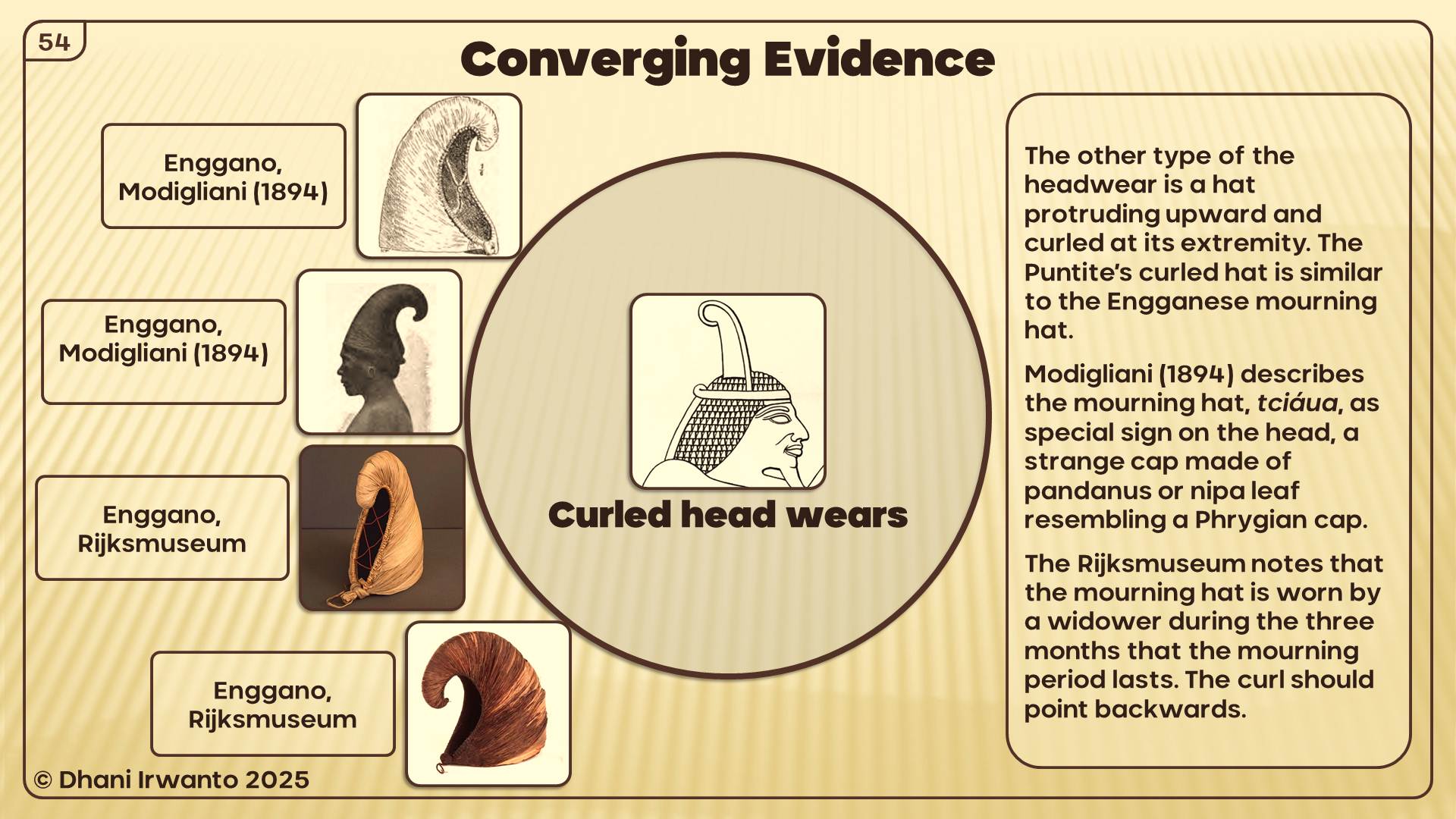
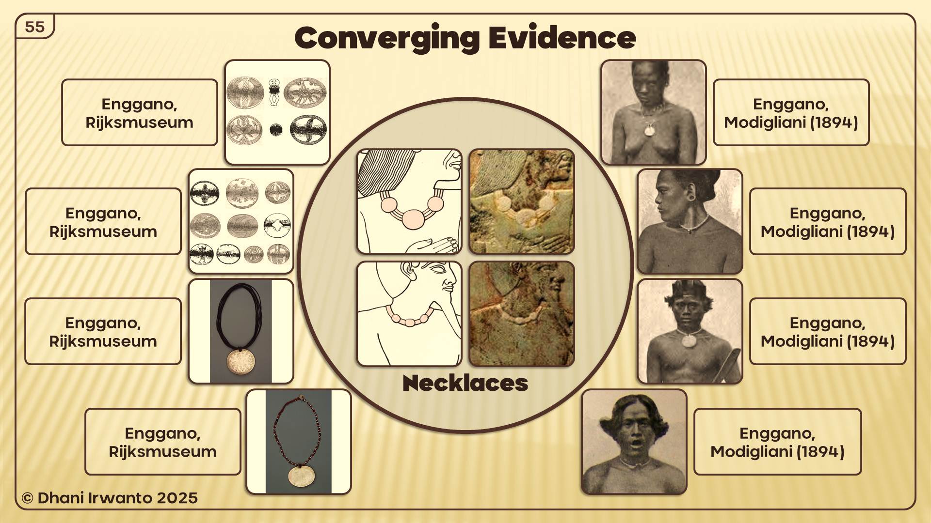
Architecture: Puntite houses on stilts match Sumatran and Enggano traditions.
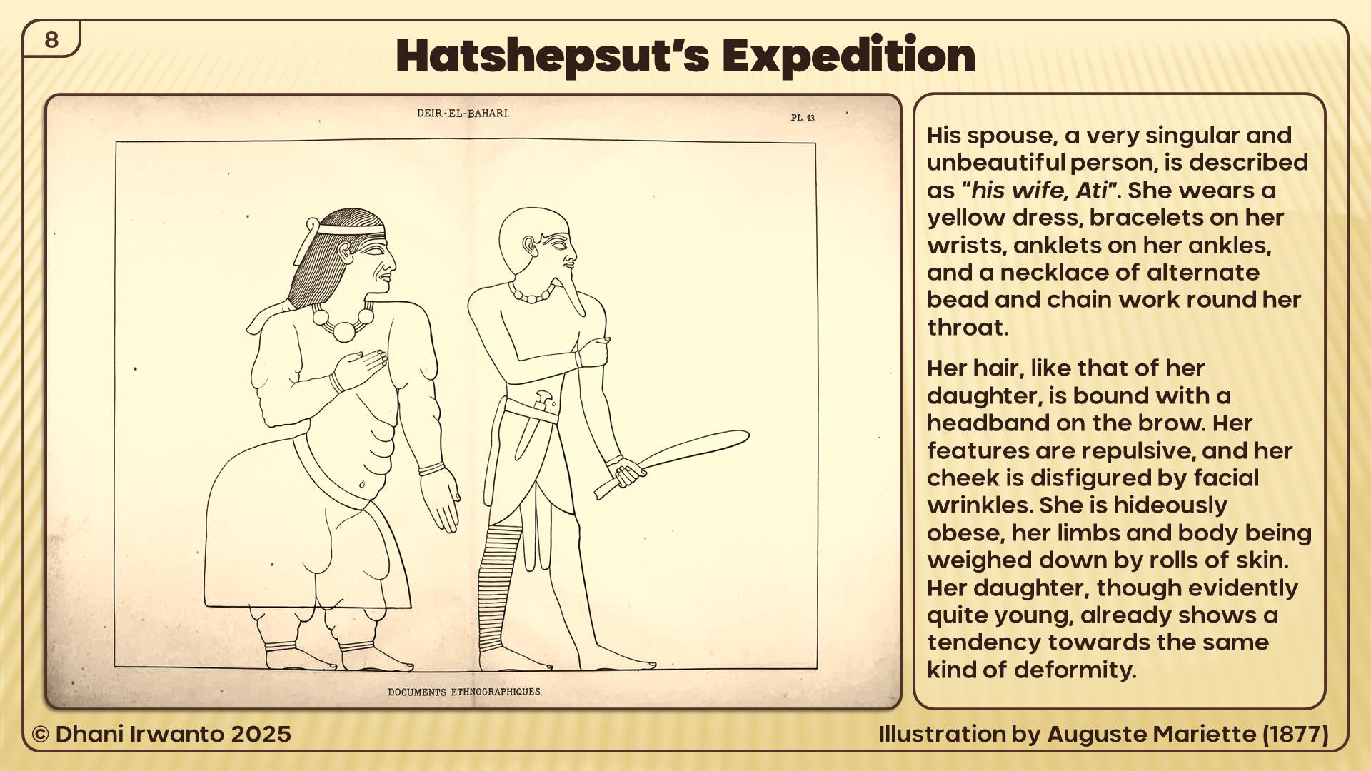
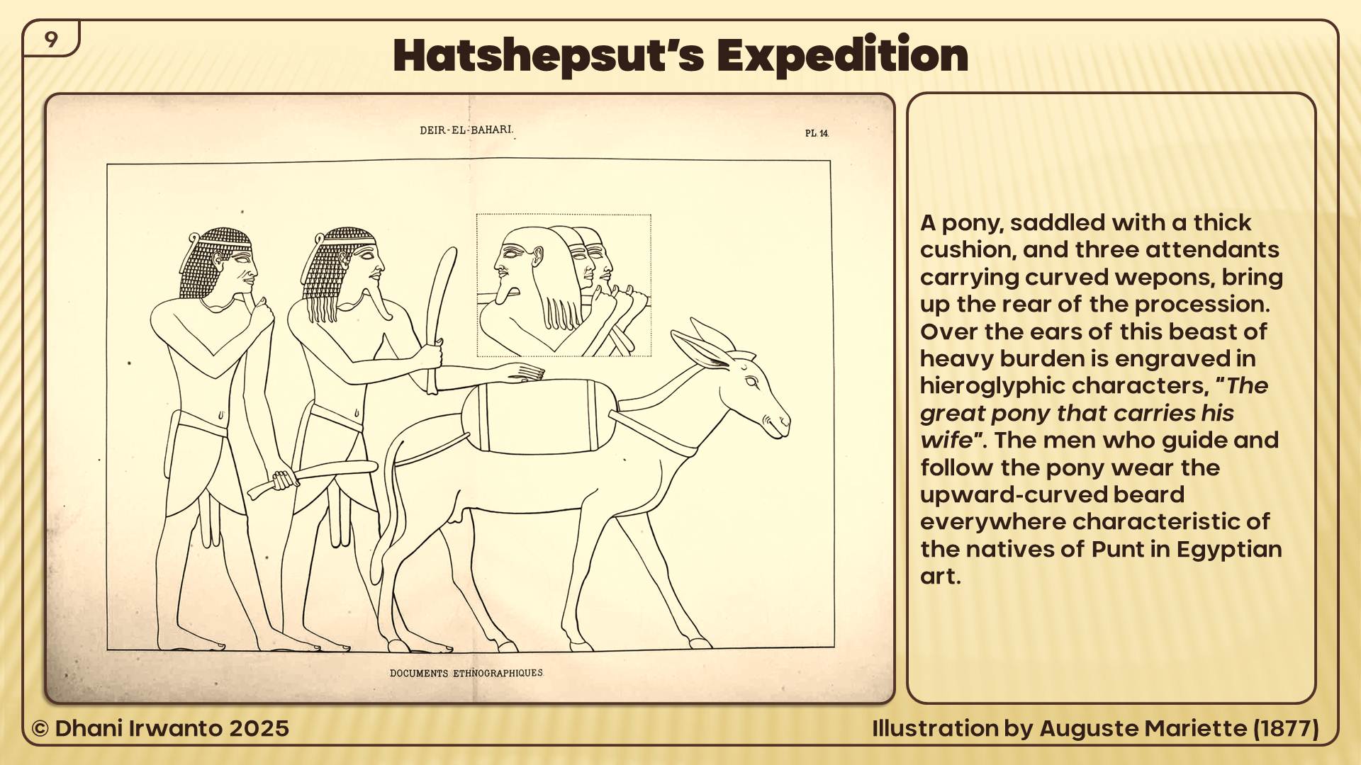
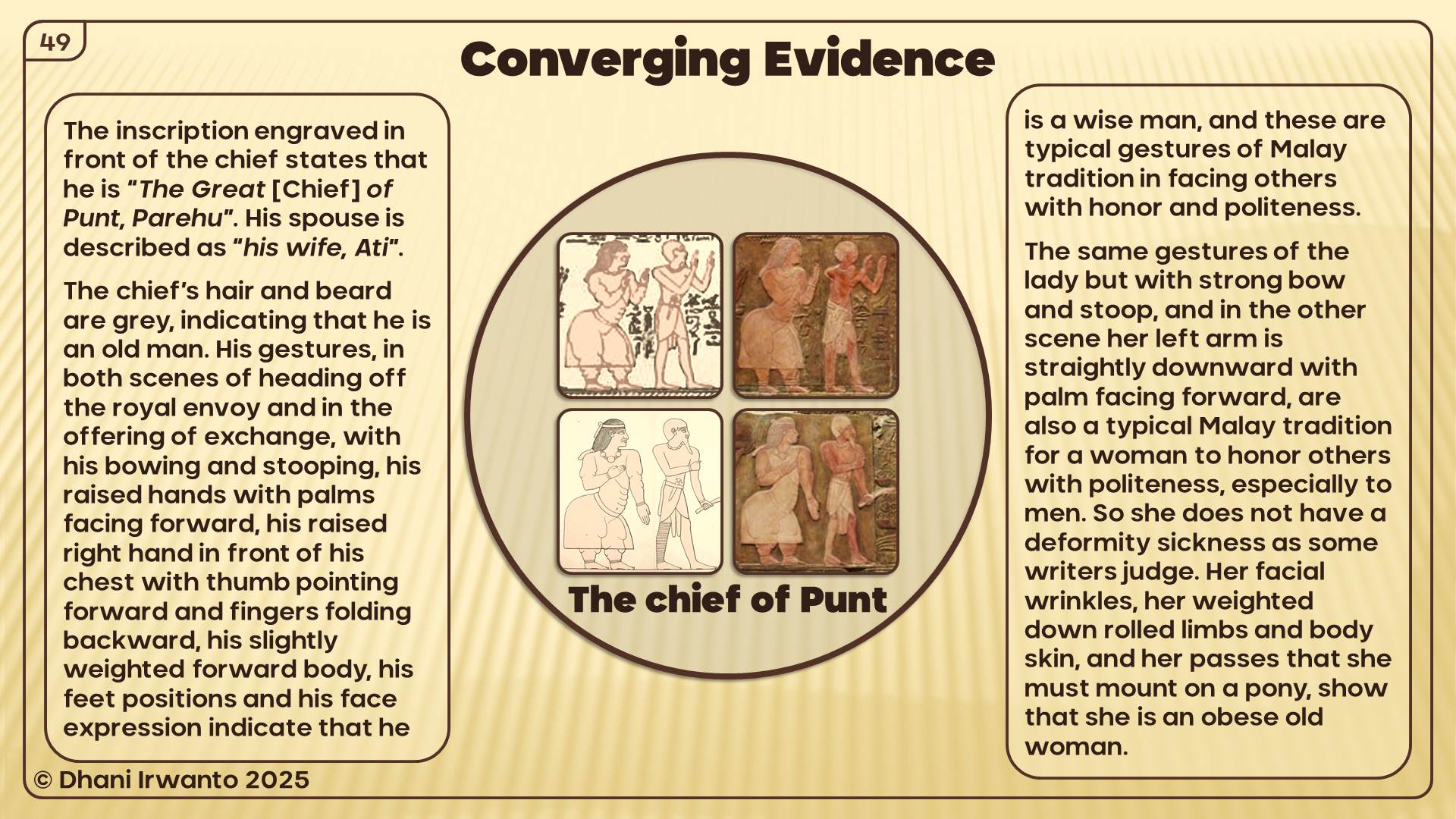
People: Puntites depicted with lighter skin, straight noses, and Malay-style dress, jewelry, and weapons.
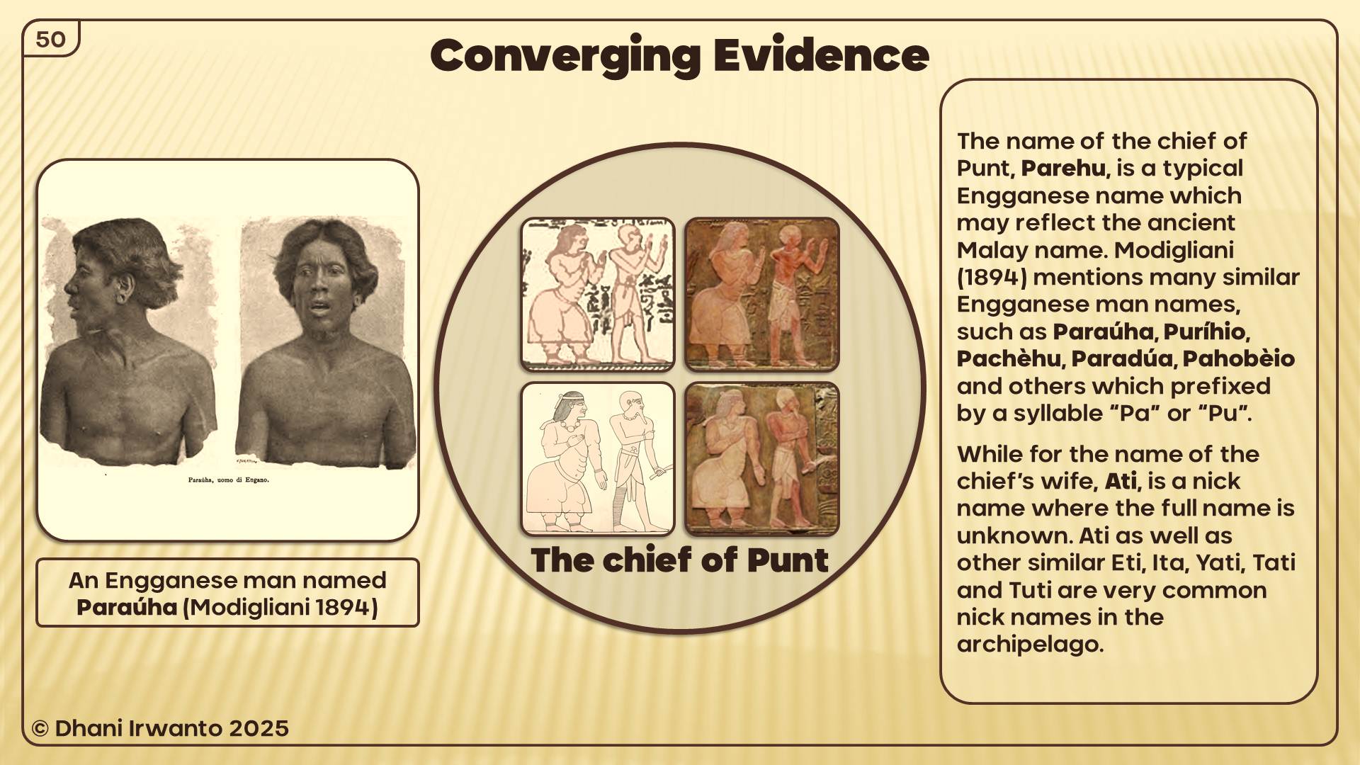
Names: Chief Parehu resembles Enggano names (Paraúha, Puríhio). His wife Ati recalls common Indonesian nicknames.
This is not coincidence—it is a cultural fingerprint.
Now let’s place this beside Neserser. The Book of the Dead speaks of Osiris enthroned at the center of six or seven concentric circles, on an island-lake in the far East. The imagery of circles, water, divine enthronement, and flood resonates directly with Plato’s Atlantis.
If the Egyptians already connected their cosmology to the far East—to Sumatra, the “land of origin”—then the parallels between Neserser and Atlantis may not be abstract at all. They may reflect Egypt’s sacred geography projected upon Southeast Asia.
The Thread of Transmission:
Egypt knew Sumatra as Punt—the source of incense, gold, and sacred products.
Neserser represented a circular, island-paradise of Osiris in the East.
Atlantis, as told by priests to Solon, may have drawn on this same Eastern sacred memory.
In this light, Atlantis is not a purely Mediterranean invention. It may encode Egypt’s knowledge of Southeast Asia, filtered through myth, memory, and Plato’s philosophy.
In the Book of the Dead (Papyrus of Nu), we encounter Neserser—“the Island of Fire” in the far East, where the sun rises. It is the dwelling place of Osiris (Ausares, Asar) and Thoth. The imagery is vivid: Osiris enthroned in the center of six or seven concentric circles on a sacred lake, a volcanic-like “island and lake of fire” dedicated to Ra, floods that reshape the landscape, and Thoth residing nearby, keeper of divine knowledge.
Later Egyptologists described these circles as “hidden after the flood.”
Atlantis echo: Here again are concentric circles, a sacred island, a great flood, and divine kingship.
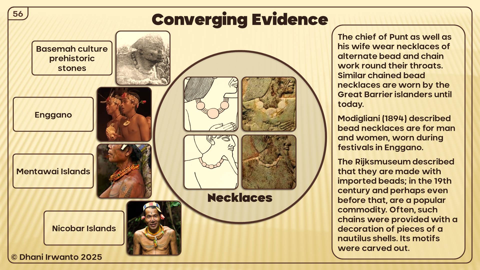
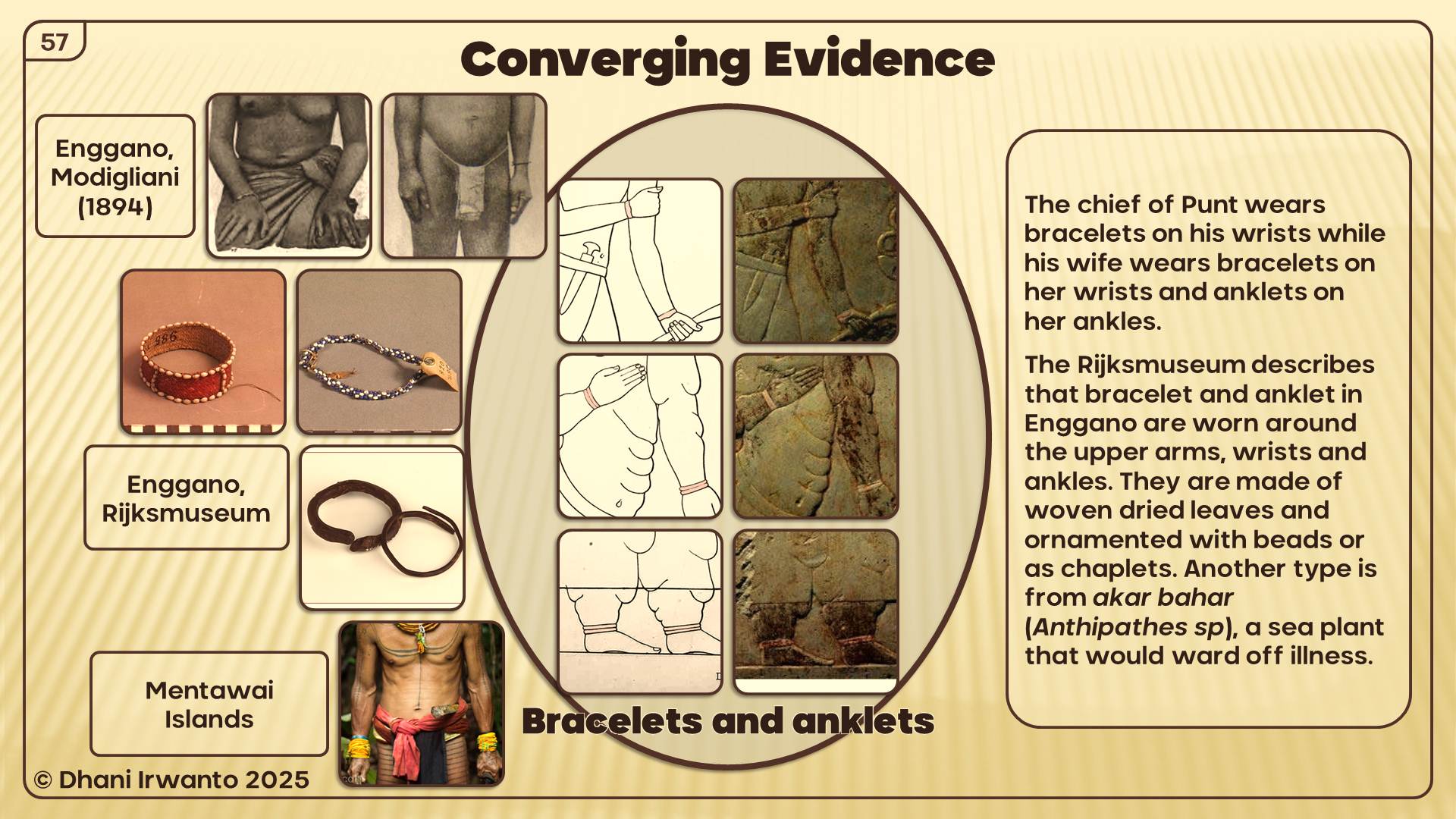
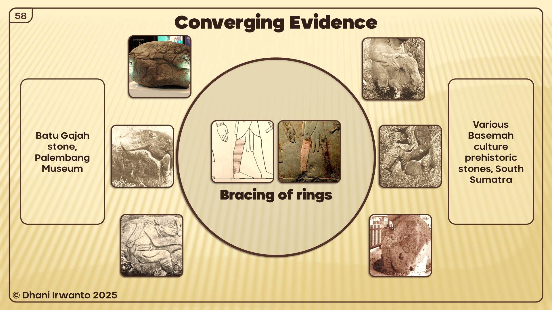
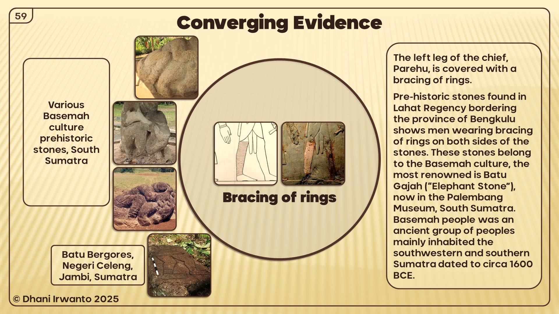
Connecting the Dots: A Discussion
The parallels between Plato’s Atlantis and global myths—from Tamil Kumari Kandam to Mesopotamian Nisir, from Iranian Kangdez to Biblical Eden—show a striking pattern of shared motifs: floods, lost paradises, concentric sacred cities, and divine kingship.
Among these, the Egyptian contribution is the most critical. Plato himself acknowledged that the story came from Egyptian priests. Their sacred geography included Neserser, the concentric island of Osiris in the far East, and their historical voyages reached as far as Punt—identified with Sumatra, the ‘Land of Origin.’
When we combine Neserser’s sacred concentric circles with Punt’s real-world geography and resources, a powerful connection emerges: Egypt not only imagined an eastern paradise, but had knowledge of one. Atlantis may be the philosophical echo of Egypt’s long memory of Southeast Asia.
Thus, the Atlantis story can be seen as a tapestry woven from many threads—myths of lost lands, religious cosmologies, and Egypt’s own encounters with Southeast Asia. Connecting these dots allows us to glimpse Atlantis not as an isolated legend, but as part of a wider human memory of catastrophe, paradise, and rebirth.
Conclusion: When Myths Rhyme Across Oceans
Kumari Kandam, Kangdez, Neserser, Nisir, Asuras, Atlas, Eden—each speaks in its own voice, yet the chorus is familiar. Lost lands, floods, circular cities, divine kings, and paradise destroyed.
Plato may have woven a Greek philosophical tale. But the motifs he used—perhaps borrowed, perhaps remembered—echo far older and wider. Atlantis may not be alone; it may be part of a global pattern of mythic memory of catastrophe and rebirth.
Comparative Snapshot: Parallels at a Glance
A concise table to visualize recurring motifs and where Southeast Asia fits in the Egyptian knowledge frame.
Tradition/Source
Core Setting
Key Motifs
Flood/Collapse
Concentric/Sacred Center
Sea-Lord/Lawgiver
SE Asia Link
Kumari Kandam (Tamil)
Southern drowned land
Golden age, irrigated plains, gem mining, lost coasts
Yes – land swallowed by sea
No explicit circles (ordered realms)
Implied righteous kingship
Indirect (Indian Ocean south)
Kangdez (Iranian)
Fortress in the Far East, near equator
Concentric walls, metals, springs, tidal plain, volcanoes
Implied peril at sea’s edge
Yes – concentric fortifications
Sovereign order (Iranian epic)
Points East; equatorial hints
Neserser (Egypt)
Island-lake in the Far East
Osiris enthroned; 6–7 circles; ‘lake of fire’
Yes – flood imagery; ‘hidden’ after
Yes – canonical concentric circles
Osiris/Ra as sacral law & kingship
Conceptual East (sunrise); bridge to Punt
Mount Nisir (Gilgamesh)
Mountain of grounding
Paradise-like East; forests, birds, monkeys; great flood
Yes – global flood narrative
No (mountain refuge)
Divine warning & survival order
Tropical imagery resonates with SE Asia
Asuras/Ahuras (Indo-Iranian)
Cosmic moral order
Waters, oaths, boundaries (Varuna/Ahura Mazda)
Not central
Symbolic circles (order)
Yes – sea-lord/lawgiver archetype
Cultural substrate across Indo-Iran
Atlas/Poseidon (Greek)
Atlantean kingship; sea-quake god
Names tied to sea power, metals, concentric city
Yes – sudden destruction
Yes – Atlantis capital rings
Poseidon (cf. Varuna/Baruna)
By proxy via Indo-Iran → Egypt
Garden of Eden (Genesis)
Eastern paradise, 4 rivers
Pristine garden, moral test, exile
Yes – loss/expulsion (not flood)
No circles; central river hub
Implied divine law
ANE roots; not specific to SE Asia
Nusasura/Gosong Gia (Java Sea)
Shoal/reef & island lore
Name echoes (nusa + asura); local sunken-land myths
This paper reinterprets Plato’s Timaeus and Critias as a structured reservoir of signs and reframes the Atlantis account through a semiotic–linguistic method tested by consilience.
We distinguish two narrative timelines—Timeline I, a flourishing polity and its collapse ca. 9,600 BCE; and Timeline II, the Sonchis–Solon vantage ca. 600 BCE—and two catastrophic phases: Phase I (instant devastation) and Phase II (long-term subsidence and shoaling).
Treating the dialogues’ descriptions as Order-2 properties (connotative features), we reconstruct an Order-3 spatial model constrained by five thalassa domains (ringed harbour waters, Inner Sea, Outer Sea, Ocean 1 facing a mountainous margin, Ocean 2 as the true ocean with an opposite continent) and by a compass-orientation logic that yields three mouth-placement scenarios (east, south, west).
The tropical constraint at ~11,600 BP narrows candidates to the low latitudes; global filtering of macro-properties (larger than Libya and Asia [Minor], facing other islands, adjacency to an opposite continent, coconut/elephant/rice distributions) coheres uniquely in Southeast Asia (Pleistocene–early Holocene Sundaland). Among the three orientation scenarios, the East Mouth Model preserves all constraints at envelope and site scales. Within the southern semi-enclosed sea (ancient Java Sea), the model interlocks a level plain in South Kalimantan, ~100-stadia canal spacing with southward discharge, a capital-port at the reef-mantled high of Gosong Gia (ringed basins), and an eastward entrance through the Kangean Mouth. Bathymetry at Gosong Gia exhibits three benchmarks—concentric circular formations, a small hill near the center, and ~55 m surrounding depths—that anchor secondary urban-harbour properties. Consilience is operationalized as fitness: the degree to which each property improves the puzzle-like interlock across scales.
The result is a testable, Java-Sea–centric reconstruction that articulates concrete predictions for bathymetry, sub-bottom stratigraphy, remote sensing of canal regularities, and navigational corridors.
The foundation of this research is the proposition that Atlantis was a real, physical place, rather than a purely allegorical or mythical construct. The primary source for the Atlantis account is found in the works of the ancient Greek philosopher Plato—specifically, in his dialogues Timaeus and Critias. These texts offer a detailed description of Atlantis, including its location, structure, culture, and its sudden destruction. Unlike many past interpretations that confine their search to the Atlantic Ocean or the Mediterranean, this study reads Plato’s narrative literally and geographically, treating it as a precise account of a real place. This approach avoids bending the text to fit modern assumptions and instead examines it in its own historical and linguistic context.
1.2 Egyptian Origins of the Narrative
The origins of the Atlantis story lie not in Greece but in Ancient Egypt, in the sacred district of Sais (modern-day San Al-Hajar) in the Nile Delta. Around 600 BCE, the Athenian statesman, poet, and lawmaker Solon visited Sais, where he met Sonchis, a senior priest of the temple of Neith. Drawing upon inscriptions and registers preserved in the temple, Sonchis recounted the history of Atlantis as part of Egypt’s recorded past. The Egyptian origin confers a deep historical context to the Atlantis account, situating it within a long-standing written tradition.
1.3 Transmission and Transformation in Greek Tradition
After receiving the account from Sonchis, Solon intended to adapt it into an epic poem but never completed the task. Nevertheless, the story entered Greek oral tradition, where it was recited for roughly two centuries, especially during the Apaturia festivals. Over this period, the narrative underwent several transformations: localization to familiar Greek geographies, characterization of figures to fit Hellenic ideals, personalization to reflect Greek identity, and metaphorization of events. By the time Plato wrote Timaeus and Critias around 360 BCE, he had access both to Solon’s preserved account and to the semi-legendary version shaped by oral tradition. Plato’s composition merges these strands, preserving core historical elements while integrating evolved legendary layers.
1.4 Philosophical Embedding in Plato’s Dialogues
Plato presents the Atlantis story as a dialogue among Socrates, Critias the Younger, Timaeus, and Hermocrates. Critias traces the account to his grandfather, Critias the Elder, who heard it from Solon, who in turn learned it from Sonchis in Egypt. This chain of custody—Egyptian priesthood → Solon → Critias the Elder → Critias the Younger → Plato—demonstrates the layered transmission of the story. The dialogue format serves a philosophical purpose: Atlantis becomes a case study of a great civilization’s moral and political decline, illustrating Plato’s broader arguments about governance, virtue, and societal decay. Understanding the interplay of historical narrative and philosophical intent is essential to decoding the embedded geographical and historical clues in Plato’s text.
2. Methodology: Semiotic and Linguistic Decoding with Consilience
2.1 Theoretical Foundations
The methodological framework guiding this research is rooted in semiotics—the study of signs and signification—and linguistic analysis. It draws upon the seminal contributions of Ferdinand de Saussure, whose dyadic model distinguishes between the signifier (form) and the signified (concept), and Charles Sanders Peirce, whose triadic model adds the interpretant, acknowledging the role of perception and interpretation in meaning-making. Roman Jakobson’s insights into the syntagmatic (linear sequencing of signs) and paradigmatic (associative relationships between signs) axes of language further refine the analytical approach.
Roland Barthes’ theory of orders of signification is particularly crucial here: the first order captures the literal, denotative meaning, while the second order moves into connotation and cultural symbolism, and the third order involves mythic and archetypal narratives. In the context of the Atlantis account, the first order encompasses the explicit geographical and cultural descriptions in Plato’s Timaeus and Critias; the second order reveals the connotative properties that have persisted through centuries of adaptation; and the third order, which is the goal of this study, seeks to reconstruct a coherent historical-geographical model from these connotative signs.
2.2 Analytical Process
The analytical process begins by treating Plato’s dialogues not as pure allegory, but as structured repositories of signs—linguistic, cultural, and topographical—that can be decoded systematically. Syntagmatic analysis examines the sequential order in which descriptions appear, recognizing that narrative structure often reflects spatial relationships or functional hierarchies in the described environment. Paradigmatic analysis explores alternative signs that could occupy the same narrative position, revealing contrasts and associations embedded in the text. Pragmatic analysis situates these signs in their historical, cultural, and environmental contexts, enabling the identification of meanings that would have been evident to Plato’s contemporaries but are obscure to modern readers. Context clues, such as references to seasonal cycles, resource abundance, or navigational constraints, are treated as integral to decoding the embedded realities behind the mythic veneer.
2.3 Archaeological Analogies
The interpretative process is further enriched by analogies drawn from archaeological practice. The potsherds model treats narrative fragments like shards of pottery, requiring careful reassembly to recover the original vessel—in this case, the coherent account of Atlantis. Anastylosis, a method of restoring ruins using original materials, parallels the selective integration of verified textual elements while avoiding speculative insertions. The puzzle analogy emphasizes the identification of primary pieces (corner and edge elements) that anchor the reconstruction, followed by the fitting of secondary pieces that complete the picture. Each fragment is examined for inherent properties, relational connections, and contextual compatibility with other fragments before it is integrated into the larger model.
2.4 Role of Consilience
At the core of this methodology is the principle of consilience: the convergence of evidence from independent, unrelated fields to support a single conclusion. In the study of Atlantis, this involves cross-verifying decoded signs from Plato’s narrative with data from geology, paleogeography, archaeology, oceanography, climatology, linguistics, and cultural history. A reconstructed Order-3 model is only considered robust if multiple disciplines independently affirm its key parameters—such as geographic setting, environmental conditions, and cultural practices. This multidisciplinary validation ensures that the reconstruction is not merely a product of literary interpretation, but a hypothesis anchored in empirical reality. The process thus moves from identifying signs in the text, through decoding their layered meanings, to testing the resulting model against the tangible record of Earth’s past landscapes and civilizations.
Plato’s account operates across two temporal reference frames that must be distinguished analytically. These frames structure how the narrative preserves both a living civilization and the memory of its aftermath.
Timeline I(Atlantis era, ca. 9,600 BCE): depicts the polity at its height and its sudden destruction; the descriptive clauses pertain to a functioning landscape of plain, canals, capital-island, and maritime gateways.
Timeline II(Sonchis–Solon vantage, ca. 600 BCE): records persistent physical residues (e.g., shoaling, impassable waters) observable long after the initial collapse; these are the lens through which Solon receives the account in Egypt.
Within and across these timelines, the narrative encodes a two-phase catastrophe model that explains both the instant ruin and the long-term navigational impediment.
Phase I— Instant devastation: violent earthquakes and floods culminating “in a single day and night of misfortune” (Timaeus 25c–d; cf. Critias 108e, 112a).
Phase II — Slow subsidence and shoaling: progressive settling and near-surface obstruction described as “even now… impassable and unsearchable” (Timaeus 25d; Critias 111b–c).
In semiotic terms (Barthes), the features extracted from the dialogues are treated as Order–2 signifieds—connotative properties (e.g., navigational “mouth,” rectangular plain, canal grid, reef-mantled shoal). These Order-2 properties are the inputs to an Order-3 reconstruction: a coherent, testable historical-geographical model. Validation proceeds by consilience—independent convergence from geology, paleogeography, archaeology, oceanography, biogeography, and navigation studies.
3.2 Time Frame Phases (Timeline I & Timeline II) with Phase I/II Catastrophe Context
Timeline I(Atlantis Era, ca. 9,600 BCE) profiles the polity prior to and at the onset of Phase I catastrophe. The following items are extracted from Plato with clause control and treated as Order-2 properties.
Timeline I/Phase I — Order-2 Properties:
Tropical-belt indicators: year-round fertility, hydrological abundance, and megafauna (elephants) consistent with warm, rainy conditions (Critias 113e; 114e–115a).
Location beyond a functional ‘mouth’ (Pillars of Heracles), marking transition from the outer sea into an enclosed inner sea (Timaeus 24e–25a; Critias 113c).
Regional scale “larger than Libya and Asia [Minor] combined” (Timaeus 25a).
Topography and orientation of the continental frame: a great level rectangular plain “three thousand by two thousand stadia” (~555 × 370 km) open southward to the sea and sheltered by mountains to the north (Critias 118a–b); moreover, “towering mountains on the side toward the ocean” characterize the ocean-facing margin (Critias 118a).
Engineered waterways: inland canals at ~100 stadia (~18.5 km) spacing with traverse connectors; drainage supplied by mountain streams (Critias 118c–d; 113e–114a).
Capital-port city organized in concentric rings of land and water; bridges and a straight canal from the sea (Critias 115c–116a; 115d–e).
Material palette: quarries of white, black, and red stone; hot and cold springs (Critias 116a–b; 113e).
Metals and resources: orichalcum alongside gold, silver, tin; abundant timber and agriculture (Critias 114e–115a).
Phase I catastrophe: instant devastation by earthquake and flood; “in a single day and night… disappeared into the depths” (Timaeus 25c–d; Critias 112a).
Timeline II (Sonchis–Solon vantage, ca. 600 BCE) records the landscape after Phase I, during Phase II’s long-term adjustments. Order-2 readings privilege the connotative, physically persistent meanings over the bare literal phrasings.
Timeline II/Phase II — Order-2 Properties:
Persistent near-surface obstruction (Order-2 reading): a reef-mantled shoal created by subsidence and subsequent carbonate accretion, producing long-lived impassability for vessels; cf. the Order-1 clause “even now… impassable and unsearchable… very shallow shoal (of mud)” (Timaeus 25d; Critias 111b–c).
Fragmentation of the former landmass into islands; approach to the former capital unnavigable due to reefal mantling (inferred from the enduring obstruction and navigational context).
Dense vegetation and abundant fauna, including elephants (Critias 114e).
Sustained agricultural richness in a warm, rainy regime: “all kinds of fruits and crops” (Critias 114e–115a).
3.3 Sea-Mouth and Pilotage Sequence: Navigational Signifiers
The narrative encodes a maritime gate (“Pillars of Heracles”) and a structured approach route. Crucially, the text implies five distinct thalassa domains, which must not be conflated:
Ringed harbour waters — the concentric salt-water basins of the capital (Critias 115c–116a).
Inner Sea — the enclosed basin reached through the mouth (Critias 113c).
Outer Sea — the sea immediately beyond (faced by) the mouth that contains “other islands” (Timaeus 24e–25a).
Ocean 1 — the oceanic margin that faces the “towering mountains” of the continent (Critias 118a).
Ocean 2 — the “true ocean” adjacent to the Outer Sea and containing the “opposite continent” (Timaeus 24e–25a).
Accordingly, the Outer Sea is not the same as Ocean 1. The pilotage sequence proceeds: Outer Sea → Mouth (Pillars) → Inner Sea → Straight Canal → Ringed Harbour Waters (Timaeus 24e; Critias 113c; 115d–e; 115c). Ocean 1 pertains to the continental ocean-facing margin (mountainous), while Ocean 2 denotes the broader oceanic realm with the opposite continent.
Note on identity and orientation: Ocean 1 and Ocean 2 may describe the same oceanic body when considered from different azimuthal sides relative to the system’s geometry. In such cases, “Ocean 1” denotes the segment confronting the continental mountain front (Critias 118a), whereas “Ocean 2” denotes the broader continuity that includes the opposite continent (Timaeus 24e–25a). The distinction is directional, not categorical.
3.4 Geographical Compass-Orientation Layout Model
A compass-oriented reading of the Order-2 properties yields a spatial logic without fixing a modern map. We adopt the five θάλασσα [thálassa; body of salt water] definitions above: Ringed Harbour Waters; Inner Sea; Outer Sea; Ocean 1; Ocean 2.
The level plain is “open to the sea” on its south and “sheltered by mountains” on its north (Critias 118a–b); hence, the Inner Sea lies to the south of the plain.
Main canals within the plain “discharge toward the city” (Critias 118c–d), implying southward flow toward the capital’s maritime approach.
The capital-port with ringed salt-water basins is accessed from the Inner Sea (Critias 115c–116a; 115d–e). Depending on sea-level state (Holocene transgression), it lies at the southern edge of the plain or on a separate island along the north coast of the Inner Sea.
The sea-mouth cannot be north of the Inner Sea (the plain’s north is mountainous). It may lie to the east, south, or west of the Inner Sea (Timaeus 24e; Critias 113c).
The Outer Sea is the water body directly faced by the mouth and contains the other islands (Timaeus 24e–25a).
Ocean 1 is the oceanic margin facing the towering mountains of the continental frame (Critias 118a).
Ocean 2 is the “true ocean,” adjacent to the Outer Sea and containing the opposite continent (Timaeus 24e–25a).
The boundless continent that encloses the Inner Sea occupies the azimuths other than the mouth; on its ocean-facing side toward Ocean 2 it bears “towering mountains” (Critias 118a).
Ocean 1 and Ocean 2 may be hydrographically connected and may even be the same oceanic body viewed from different sides; they need not be colinear with the mouth-facing Outer Sea relative to the Inner Sea and plain.
From the compass-orientation constraints above, the sea-mouth can lie on only three azimuths relative to the Inner Sea and plain—east, south, or west (cf. Timaeus 24e; Critias 113c). These define three alternative spatial models that will guide puzzle-assembly in the reconstruction.
East-Mouth Model
The mouth faces east toward the Outer Sea (with “other islands,” Timaeus 24e–25a). The Inner Sea lies south of the plain; the capital’s access remains from the north coast of the Inner Sea. Ocean 1 (mountain-facing) and Ocean 2 (true ocean with the opposite continent) may occupy different azimuthal sectors to the east/southeast; they can be hydrographically connected or even the same oceanic body seen from different sides.
South-Mouth Model
The mouth opens directly to the south from the Inner Sea to the Outer Sea. The canal flow remains southward toward the city; capital placement at the southern edge of the plain (or as a near-shore island) is emphasized. The Outer Sea abuts Ocean 2, and the mountainous Ocean 1 margin bounds a separate sector of the continental frame.
West-Mouth Model
The mouth faces west to the Outer Sea with islands. The Inner Sea still lies south of the plain, and the canal grid drains southward to the capital. Ocean 1 denotes the mountainous ocean margin on the continental side (Critias 118a), while Ocean 2 is the broader oceanic realm with the opposite continent (Timaeus 24e–25a); as above, they may be connected or represent different sides of one oceanic body.
(a) East-Mouth Model
(b) South-Mouth Model
(c) West-Mouth Model
Figure 1.Three alternative compass-oriented spatial models without fixing a modern map. (a) East-Mouth Model, (b) South-Mouth Model, (c) West-Mouth Model. 1. Boundless continent. 2. Towering mountain. 3. Other islands. 4. Opposite continent. 5. Ocean 1. 6. Ocean 2. 7. Outer sea. 8. Inner sea. 9. Capital-port city with ringed salt-water. 10. Sea mouth. 11. Access canal. 12. Level plain open at south with waterways. 13. North side protection of plain (mountains). → Pilotage sequence. Source: author’s compass-oriented reading.
These three orientation scenarios define mutually exclusive search envelopes for spatial reconstruction. In Section 4, each model is assembled property-by-property, treating every Order-2 property as a puzzle piece. The consilience test is the fitness evaluation: how well each piece can be reconstructed (assembled) and interlock with other pieces to produce a coherent reconstructed structured object—the fully assembled puzzle of Atlantis. Fitness is assessed by concordance with independent constraints (e.g., paleoshorelines at ~–60 m, seismic/tsunami plausibility, reef-mantling and shoaling behavior, archaeological analogues, and maritime navigation patterns). The model with the highest joint fitness across properties is retained.
4. Reconstruction and Consilience Test
Section 4 translates the Order-2 properties extracted from Plato’s Timaeus and Critias into a structured, map-like Order-3 reconstruction. The procedure follows the compass-orientation logic derived in Section 3 and tests three mutually exclusive mouth-orientation scenarios (east, south, west). Each scenario defines a search envelope within which the plain, canal grid, capital-island, ringed harbours, mouth, and mountain frame must interlock. At each step, the assembled configuration is evaluated for fitness—how well every property (‘puzzle piece’) coheres with the others to approach a coherent reconstructed structured object (the fully assembled puzzle of Atlantis).
4.1 Tropical Constraint (~11,600 BP)
Plato’s clauses imply a warm, rainy climatic regime with year-round fertility, abundant hydrological resources, and megafauna such as elephants (Critias 113e; 114e–115a). As Order-2 indicators, these constrain the candidate geography to the tropical belt at the terminal Pleistocene/early Holocene transition (~11,600 BP). Regions at higher latitudes are excluded on climatic grounds.
Figure 2.Global vegetation at ~11,600 BP; tropical belt highlighted. Source: author’s compilation after standard palaeovegetation maps.
4.2 Global Narrowing to Sundaland
Within the tropical belt, the narrative properties admit multiple macro-regional possibilities that must be explicitly screened before committing to a reconstruction. The following filters are applied as Order-2 tests of possibility (not yet conclusions):
Larger than Libya and Asia [Minor] combined → Southeast Asia (Sundaland); Central America.
Facing towards other islands → Southeast Asia; Central America.
Next to an opposite continent encompassing the true ocean → Southeast Asia.
Coconut distribution → Southeast Asia, South Asia, Central America.
Elephant distribution → Southeast Asia, South Asia, Central Africa.
Rice (domestication/early cultivation) → Southeast Asia, South Asia.
When these filters are applied jointly and interpreted through the dual-timeline/dual-phase lens, the only coherent fit at the Pleistocene–early Holocene boundary is Southeast Asia (Sundaland). Moreover, the spatial logic inherent in Section 3 (plain north of an Inner Sea; canals discharging southward; capital accessed from the Inner Sea; mouth facing a field of islands; boundless continent elsewhere) selects the East Mouth Model as the configuration that best preserves all constraints for further testing.
Figure 3.World map at ~11,600 BP with converging markers; Sundaland emphasized. Source: author’s reconstruction.
4.3 Sundaland Envelope: Enclosed Sea, ‘East Mouth,’ Mountains, and Sea Level (~–60 m)
Adopting the East Mouth Model, we focus on Sundaland with sea level near −60 m at ~11,600 BP. First, the macro-properties from 4.2 remain applicable at this scale: (i) a realm larger than Libya and Asia [Minor] (Sunda Shelf extent); (ii) facing towards other islands (archipelagic fields flanking the entrance); and (iii) next to an opposite continent which encompasses the true ocean (the broader oceanic realm beyond the island field).
Second, additional properties emerge at the envelope level: a semi-enclosed sea bounded by a boundless continent on its non-mouth sides; and the necessary existence of a sea mouth providing access from the Outer Sea. Two placements satisfy these conditions: a southern semi-enclosed sea and a northern semi-enclosed sea. The southern candidate—corresponding to the ancient Java Sea—fits the orientation logic of Section 3.4 (plain to the north; canals to the south; capital accessed from the Inner Sea) and is therefore advanced to the next step.
The northern alternative satisfies the sea-mouth requirement and faces other islands (though at greater distance); however, it lacks the critical property of being ‘next to an opposite continent’—that is, adjacency to the true ocean with an opposite continental mass. Consequently, the northern option does not fully meet consilience and is set aside.
Supplementing this envelope analysis, the inner geometry (plain size and orientation, canal spacing, ringed harbours, mountain frame) is preserved without contradiction under the East Mouth Model, and is poised for site-scale evaluation in 4.4.
Figure 4.Sundaland and the ancient Java Sea: enclosed sea, eastern mouths, mountain arc; shoreline ~–60 m. Source: author’s reconstruction.
4.4 Level Plain & Canals (South Kalimantan); Capital-Port and Mouth Placement
Within the southern semi-enclosed sea (ancient Java Sea), the reconstruction reviews prior properties and specifies site-scale elements: (i) a level alluvial plain in South Kalimantan approaching the proportions of “three thousand by two thousand stadia” (Critias 118a–b); (ii) a canalizable surface allowing ~100-stadia (~18.5 km) spacing and southward discharge toward the maritime approach (Critias 118c–d; 113e–114a); (iii) the capital-port city located at or near Gosong Gia reef—a reef-mantled high that communicates with the Inner Sea; and (iv) the sea mouth placed at the Kangean Mouth, supplying the required eastward entrance from a field of islands. These elements strengthen the East Mouth Model by interlocking the plain–canal–capital–mouth geometry into a single coherent frame.
Pilotage Sequence (applied): Vessels approach from the Outer Sea through the Kangean Mouth (east-facing entrance) into the Inner Sea (ancient Java Sea), then proceed along a straight canal to the ringed harbour waters of the capital at Gosong Gia—conforming to the sequence established in Section 3.3: Outer Sea → Mouth → Inner Sea → Straight Canal → Ringed Harbours.
Figure 5.South Kalimantan level plain and canals; placement of the capital-island inside the mouth. Source: author’s reconstruction.
This subsection reviews (not tests) the set of properties related to the capital-port city as described in the narrative. They form the inventory of pieces to be matched against site-scale evidence in 4.6 and integrated by fitness in 4.7:
Rings of water and land (concentric basins).
Fortification elements associated with the rings.
An accessing passage from the sea linking the Inner Sea to the basins.
A bridge system across the rings.
An underpass (sub-ring passage) enabling movement beneath a bridge.
Harbours integrated with the ring basins.
A royal palace complex on the central island.
State officials’ housing arranged in proximity to the palace.
A small hill near the center bearing a Poseidon temple.
A horse race track associated with the ceremonial/urban core.
Figure 6.Conceptual rendering of the ringed capital-island: water/land rings, bridges, and central sanctuary. Source: author’s reconstruction.
4.6 Benchmarks at Gosong Gia (Reef-Mantled High): Bathymetry vs Plato
Bathymetric survey results at Gosong Gia exhibit three properties that map directly onto Plato’s description and thus function as benchmarks (anchoring points) for the assembly of secondary pieces listed in 4.5:
Concentric circular formations aligned with ringed basins.
A small hill close to the center consistent with the temple-bearing eminence.
Sea depth around the coral reef ≈ 55 m, coherent with a reef-mantled high and near-surface obstruction.
These benchmarks anchor the secondary urban-architectural pieces—fortifications, passage, bridges/underpass, harbours, palace, officials’ housing, and race track—within a single coherent geometry. In the puzzle metaphor, the three benchmarks are the corner/edge pieces that fix the frame.
Figure 7.City plan vs. Gosong Gia bathymetry: central knoll, annular trough ~55 – 60 m and three benchmarks. Source: author’s comparison.
4.7 Consilience Tests
Consilience is applied at every step of the reconstruction, with fitness defined as the degree to which a candidate placement of each property (‘puzzle piece’) coheres with the assembled whole. The process explicitly tests and fits possibilities—for example, choosing between the southern vs northern semi-enclosed sea in 4.3, and evaluating the applicability of the East Mouth Model as established in 4.2. The fitness measure here is configuration-specific, asking whether each step improves the interlock of all properties within the Sundaland envelope and the Java Sea focus. The scenario that maximizes joint fitness across 4.1 – 4.6 is retained for synthesis and prediction.
4.8 Testable Predictions
The reconstruction yields concrete, falsifiable expectations at site and regional scales. These predictions operationalize the consilience framework by specifying where and how the configuration should be observable. Priority tests include:
Bathymetric/sonar imaging immediately around Gosong Gia should resolve a nested, near-concentric relief consistent with ringed basins and a small central-adjacent eminence.
Sub-bottom profiling and coring around the reef rim should recover sequences indicative of rapid post-event carbonate mantling and, where preserved, tsunami-grade reworking at depth consistent with ~11,600 BP triggers.
Remote sensing and DEM analysis across South Kalimantan should reveal rectilinear drainage or anthropogenic alignments that express ~100-stadia (~18.5 km) spacing, with a net southward gradient toward the ancient Java Sea.
Along the Kangean Mouth approach, relics of controlled passages (scoured channels, sills, or anthropogenic alignments) should be mappable along plausible fairways leading toward Gosong Gia.
Within the capital footprint, geophysical survey should prioritize loci for fortification traces, bridge abutments/underpass features, harbour aprons, palace/administrative platforms, the temple-bearing hill, and a linear/elliptical race-track embankment.
5. Conclusion
This study has treated Plato’s Timaeus and Critias as a structured repository of signs, extracting Order-2 properties (connotative features) and assembling them into an Order-3 reconstruction that is explicitly tested by consilience. The analytical scaffold distinguishes two narrative timelines (Timeline I, ca. 9,600 BCE; Timeline II, ca. 600 BCE) and two catastrophic phases (Phase I, instant devastation; Phase II, long-term subsidence and shoaling). Within this frame, the maritime system is parsed into five thalassa domains—ringed harbour waters, Inner Sea, Outer Sea, Ocean 1 (ocean-facing mountain margin), and Ocean 2 (true ocean with the opposite continent)—and constrained by a compass-orientation logic that yields three mutually exclusive mouth placements (east, south, west).
Across Sections 4.1–4.4, the reconstruction proceeds stepwise. First, the tropical constraint (~11,600 BP) filters candidates to the low latitudes. Second, global screening of narrative properties (larger than Libya and Asia [Minor]; facing other islands; next to an opposite continent encompassing the true ocean; coconut/elephant/rice distributions) yields a coherent fit in Southeast Asia during the Pleistocene/early Holocene exposure of Sundaland. Third, among the three orientation scenarios, the East Mouth Model best preserves the spatial logic derived in Section 3: a level plain to the north of an Inner Sea, southward canal discharge toward a maritime capital, a mouth that faces a field of islands, and a boundless continental frame elsewhere. At envelope scale (Section 4.3), the southern semi-enclosed sea (ancient Java Sea) satisfies the ‘opposite continent’ adjacency that the northern alternative lacks; thus the southern option advances.
At site scale (Section 4.4), the model interlocks: (i) a level alluvial plain in South Kalimantan approaching Plato’s stated dimensions (three thousand by two thousand stadia); (ii) a canalizable surface with ~100-stadia (~18.5 km) spacing and southward discharge; (iii) the capital-port’s ringed harbour waters positioned at a reef-mantled high at Gosong Gia; and (iv) an eastward entrance at the Kangean Mouth, yielding a pilotage sequence of Outer Sea → Mouth → Inner Sea → Straight Canal → Ringed Harbours. Section 4.5 inventories the capital properties from the dialogue (concentric rings of water and land; fortification; accessing passage; bridges and an underpass; harbours; royal palace; state officials’ housing; a small hill near the center with a Poseidon temple; and a horse race track), while Section 4.6 identifies three bathymetric benchmarks at Gosong Gia—concentric circular formations, a small central-adjacent hill, and ≈55 m surrounding depths—that anchor those secondary pieces in a coherent urban-harbour geometry.
Consilience in this framework is operationalized as fitness at every step: the degree to which each Order-2 property (puzzle piece) improves the interlock of the assembled structure without generating contradiction. The northern semi-enclosed sea option, while satisfying a mouth and facing other islands (at distance), fails the ‘next to an opposite continent’ criterion and therefore does not achieve joint fitness. By contrast, the southern semi-enclosed sea under the East Mouth Model maintains coherence from envelope to site scale and accommodates the Timeline II residue of a persistent obstructor as an Order-2 reef-mantled shoal.
The testable predictions generated by this synthesis are now consolidated in Section 4.8 to remain adjacent to the reconstruction steps they evaluate. The model stands as a map of verifiable expectations—an invitation to test a very old story against the seafloor and the sediments that still remember it.
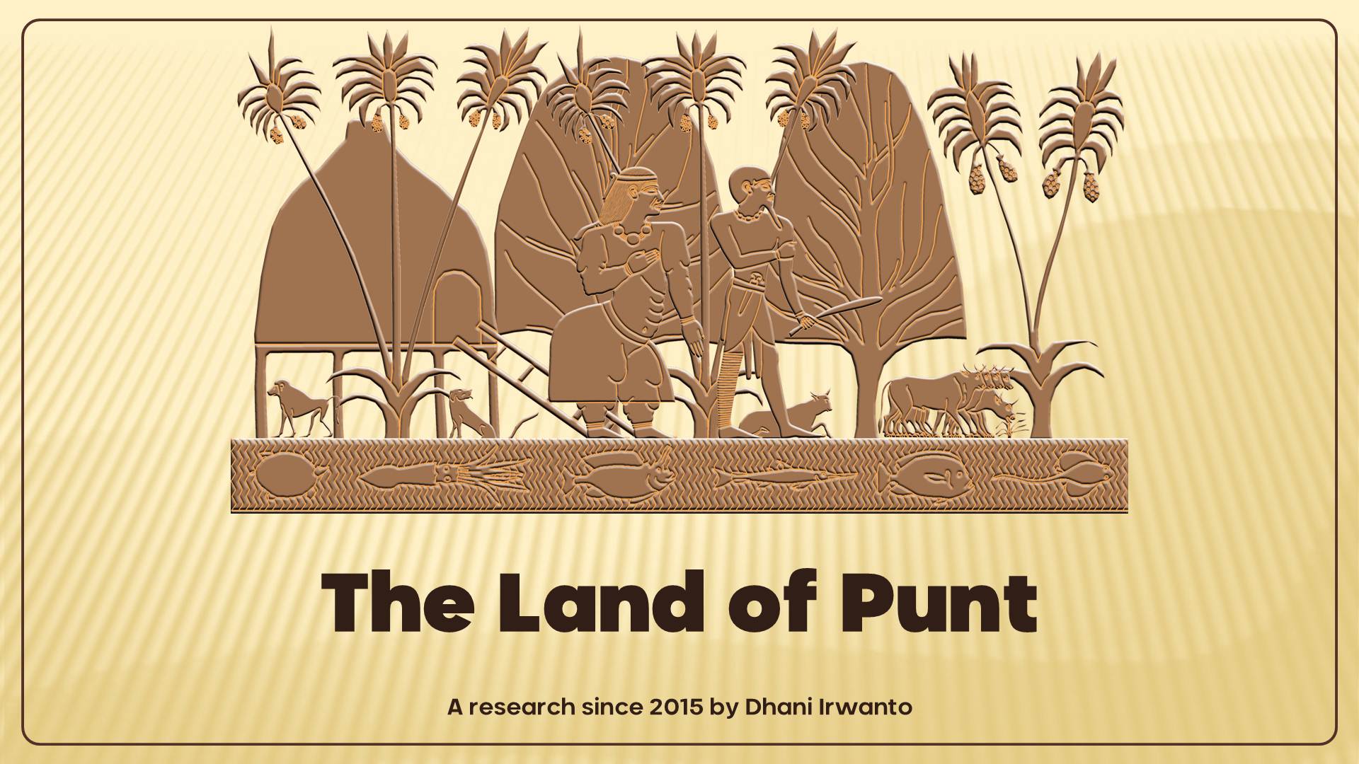
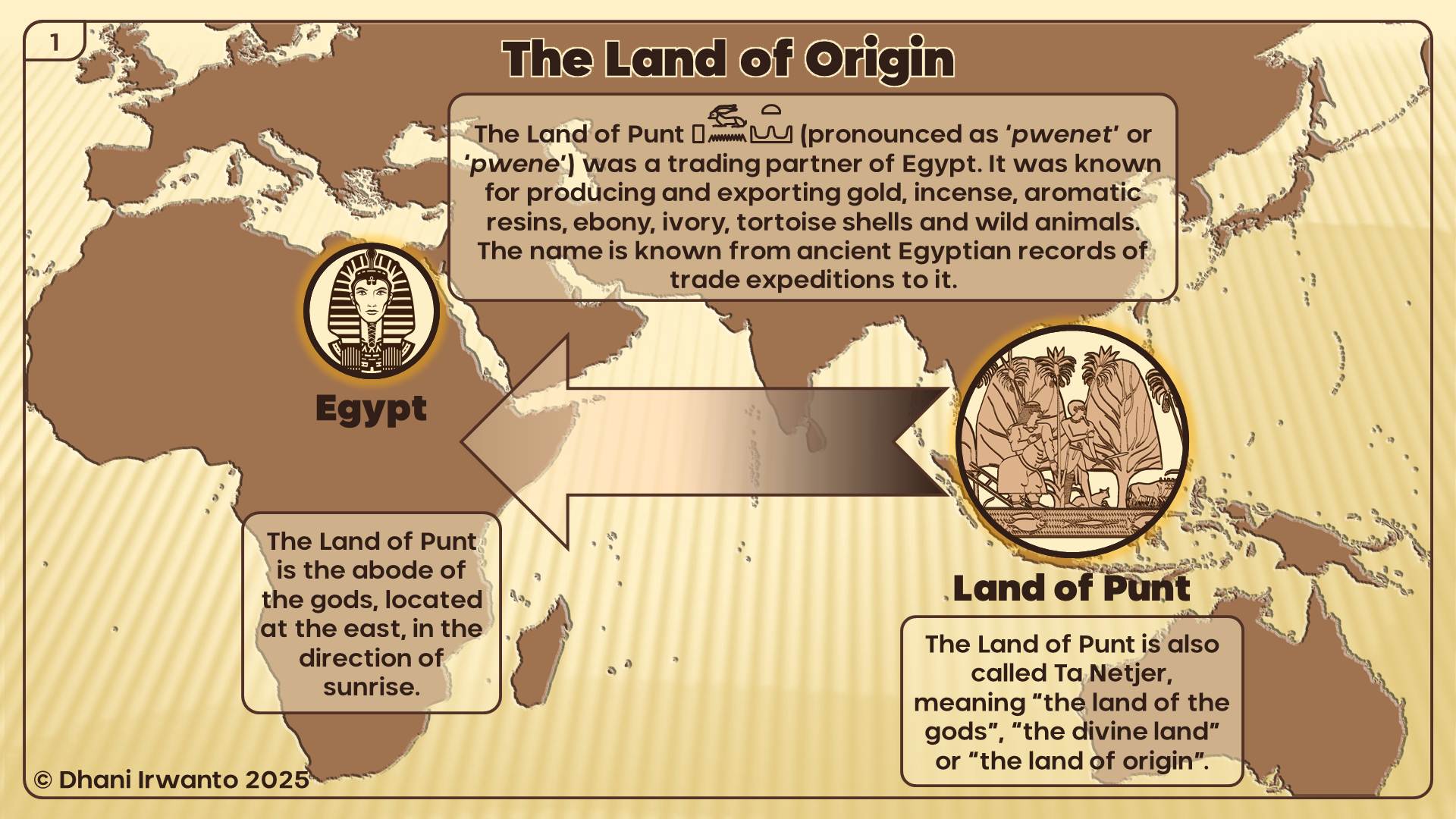
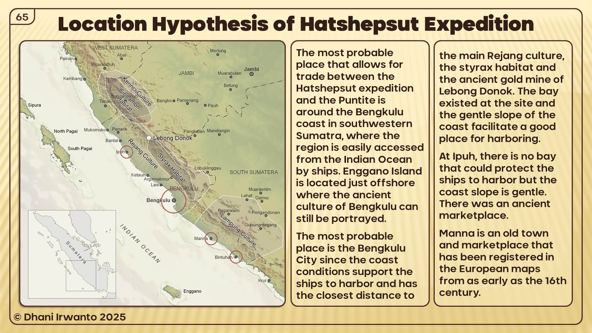
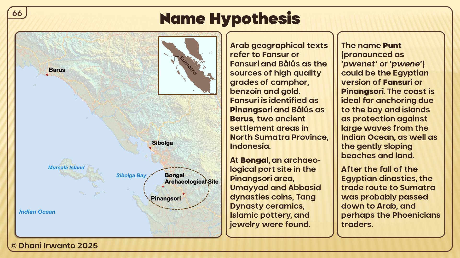
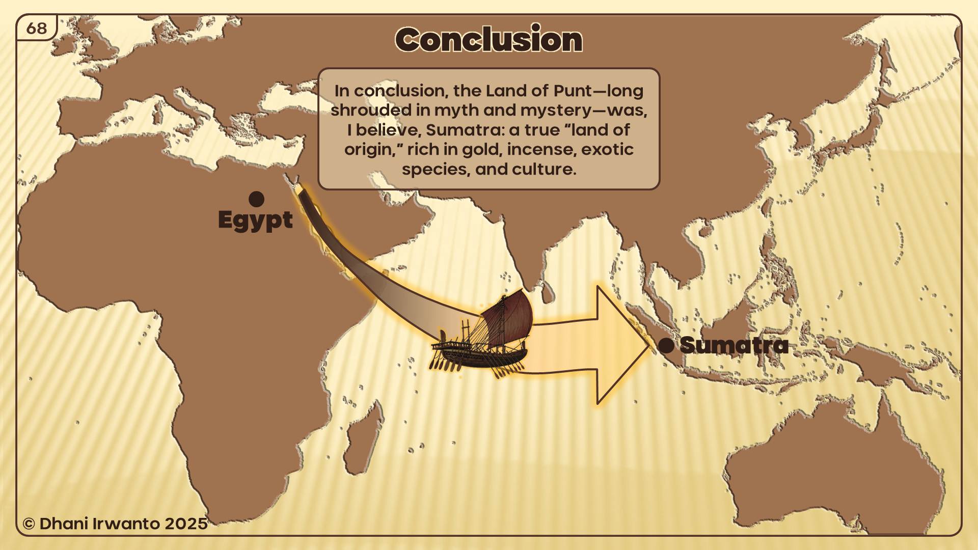
The Land of Punt has long stood as one of history’s enduring mysteries. Ancient Egyptian inscriptions speak of a distant, exotic land—rich in gold, incense, precious woods, and rare animals—referred to as “Ta Netjer,” the land of the gods, or the land of origin. For centuries, the true location of Punt has been debated by scholars, with hypotheses ranging from Africa to Arabia and beyond. Yet, none have fully accounted for the rich detail preserved in the records of Egypt’s trade expeditions.
This presentation, the culmination of years of independent research, re-examines the evidence for Punt’s location through an interdisciplinary approach. By carefully analyzing historical texts, archaeological findings, botanical and zoological records, and living cultural traditions, I argue that the Land of Punt is best identified not in Africa, but on the island of Sumatra and its surrounding regions in Indonesia.
Key evidence—including the flora and fauna described by the Egyptians, the products traded, the architectural styles, and the physical features of Punt’s people—find their closest parallels in Sumatra’s unique environment and ancient cultures. Ancient Sumatran ports such as Bengkulu, Barus, and Pinangsori emerge as strong candidates for Punt’s legendary harbors.
By bringing together linguistic, historical, and ethnographic perspectives, this presentation invites you to reconsider the origins of the Land of Punt and, in doing so, explore new connections between the ancient civilizations of Egypt and Southeast Asia.
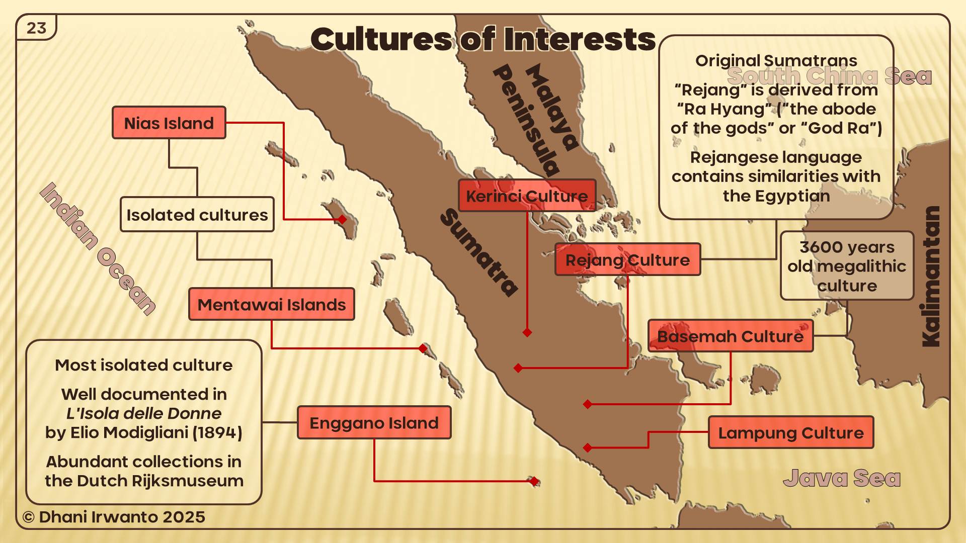
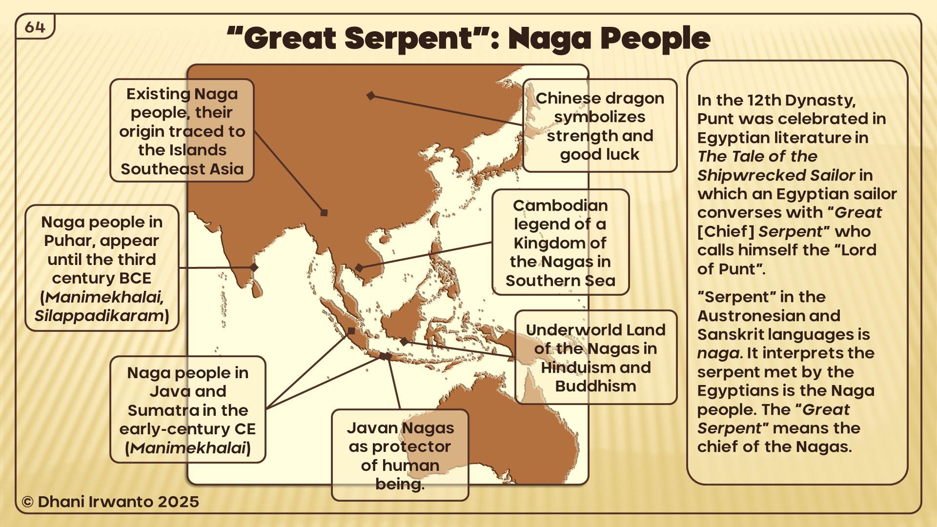
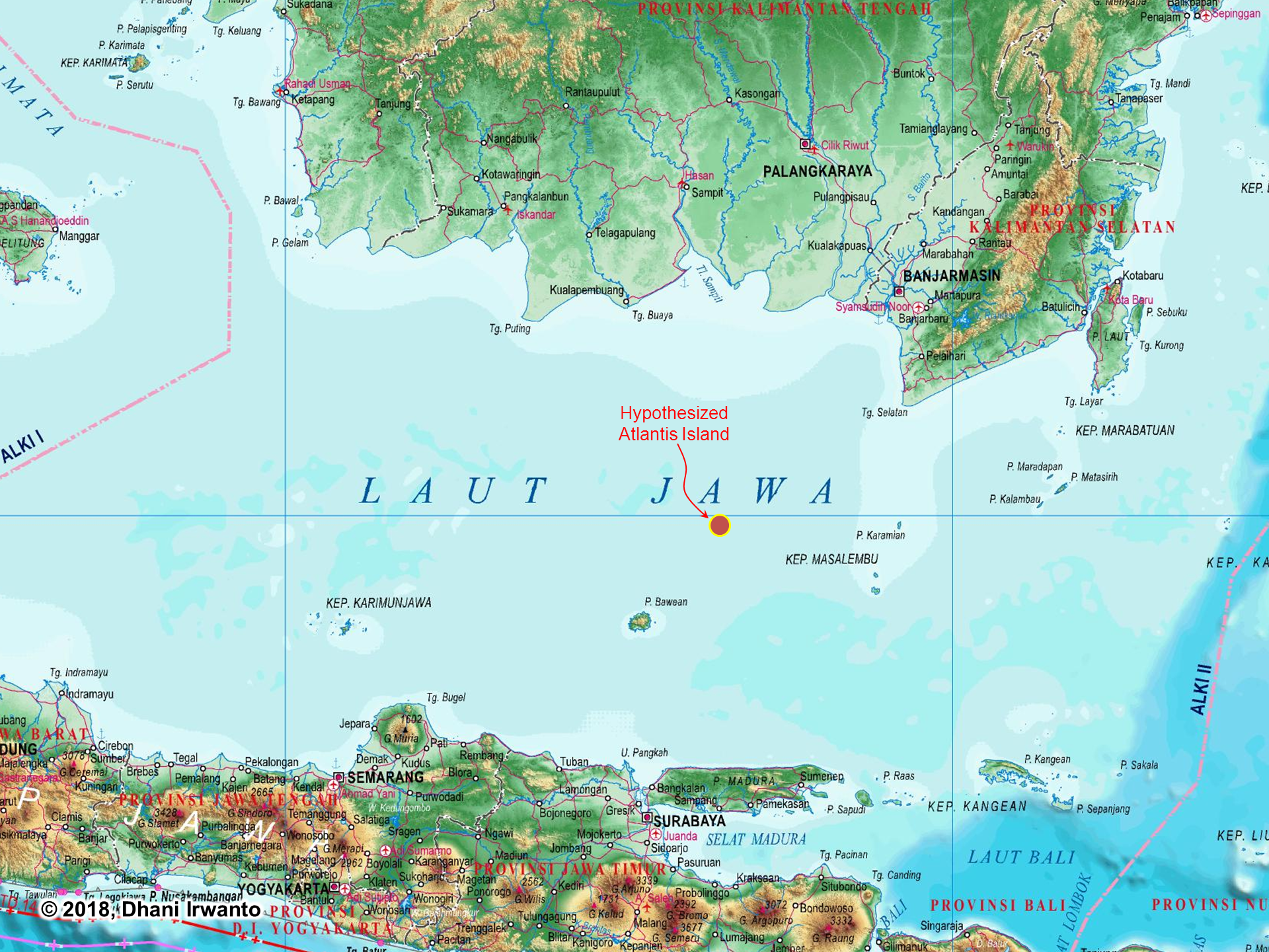
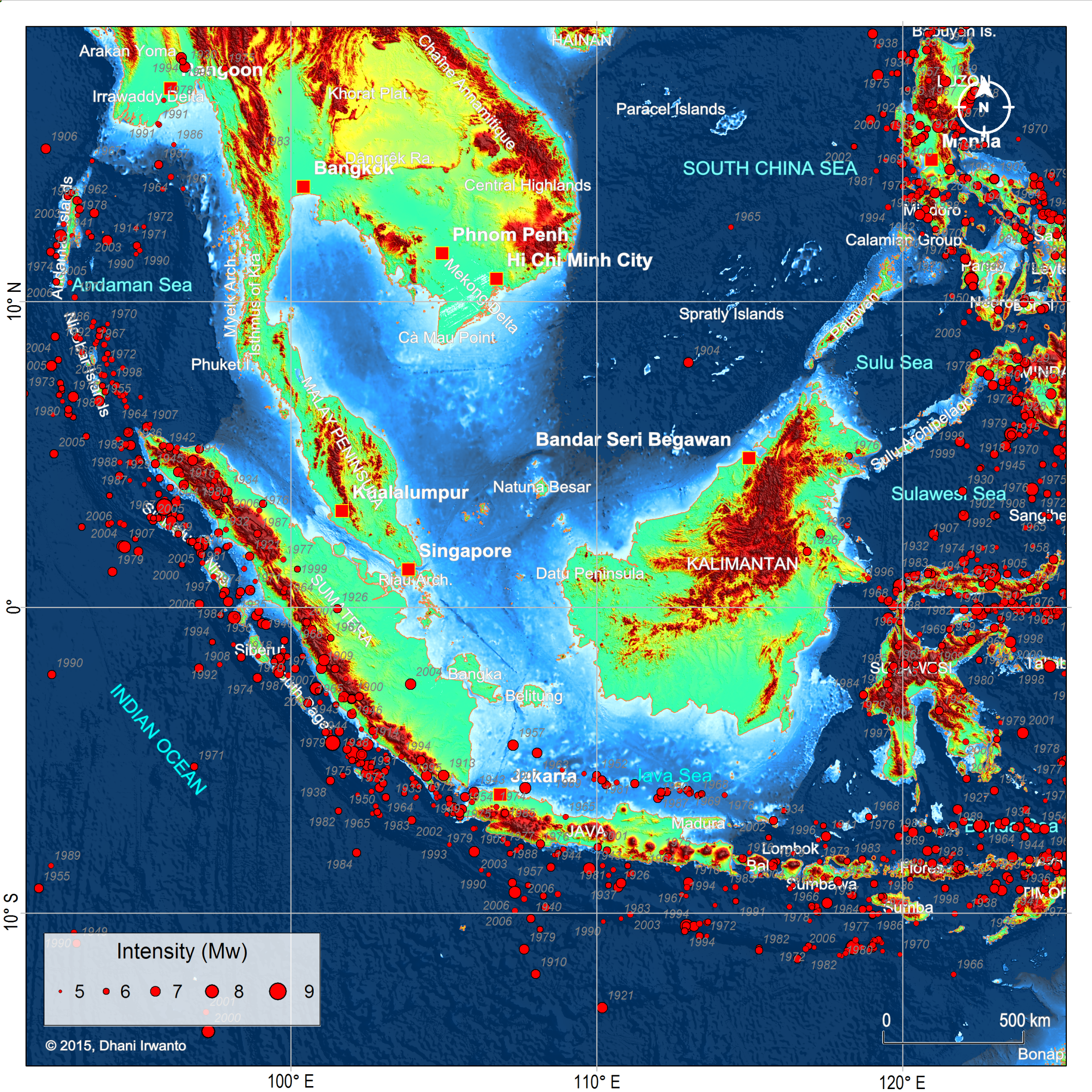
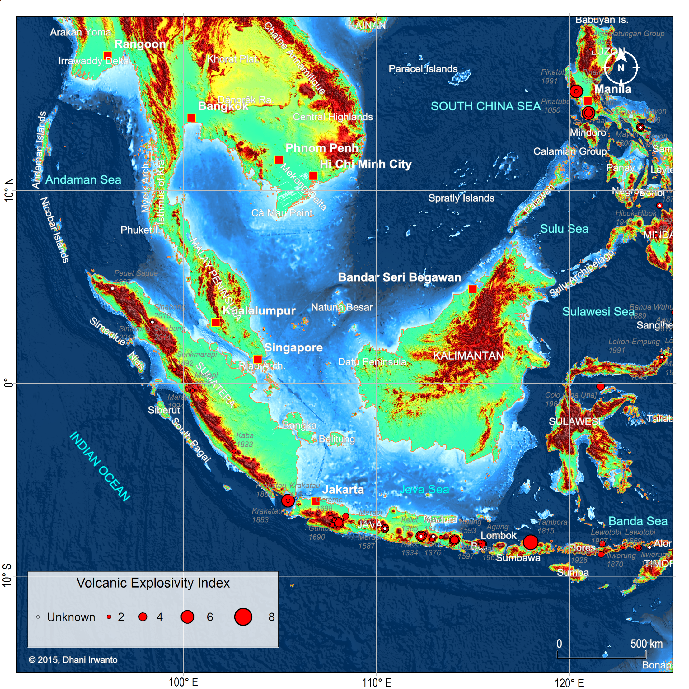
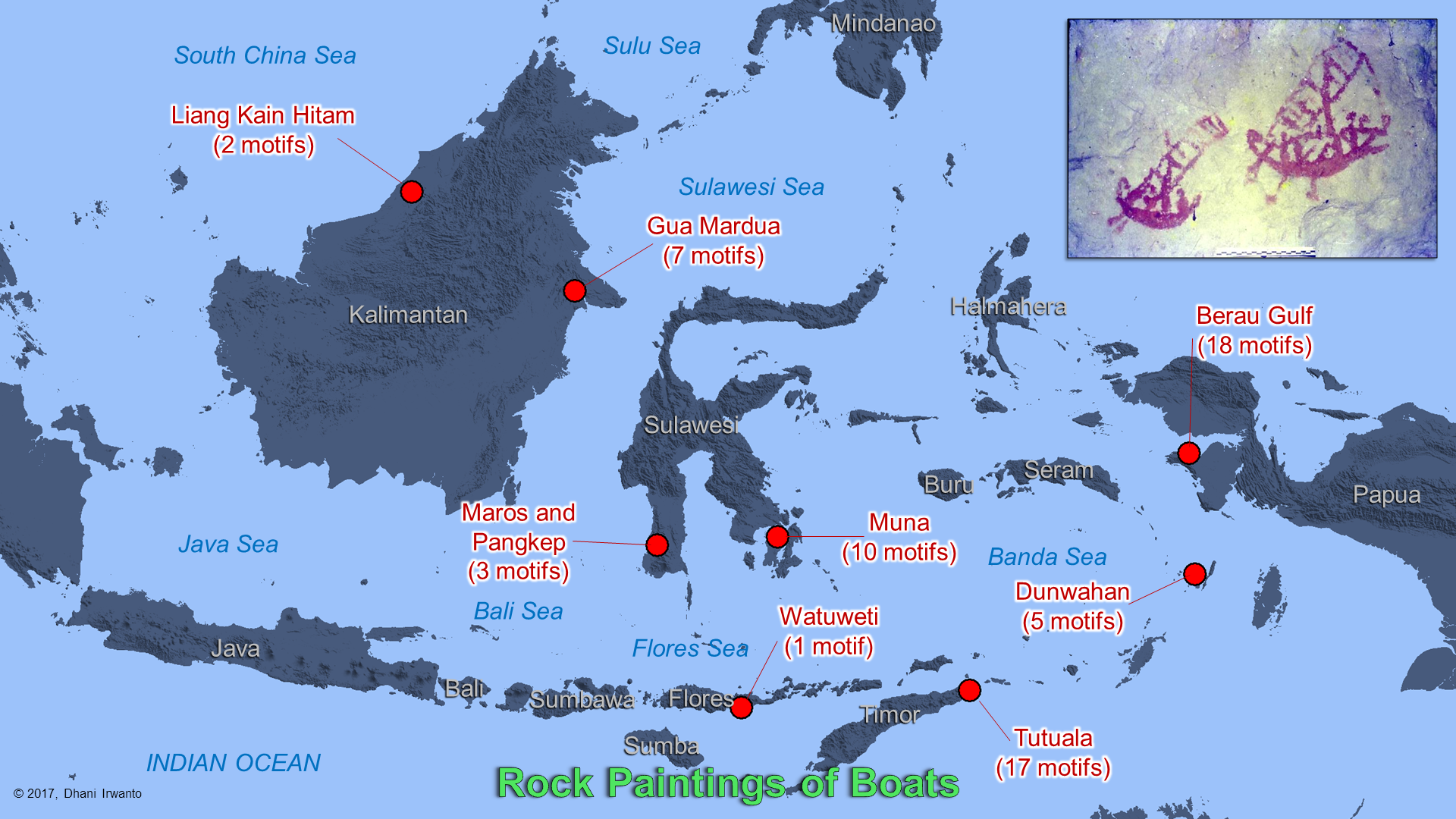
In 2017, I visited an island in the middle of the Java Sea, namely the Bawean Island, to deliver a presentation about the island’s connection with Atlantis. I spent a few days there, wandering around the tiny island to observe and talk to every resident I met. There is an interesting thing that I got when talking with them. Some people told a legend about the existence of a mysterious island located on the north of the island, in the middle of the Java Sea, which is now drowned. They also told about the frequent occurrence of fishing boats or vessels that ran aground or lost when sailing near the mysterious island.
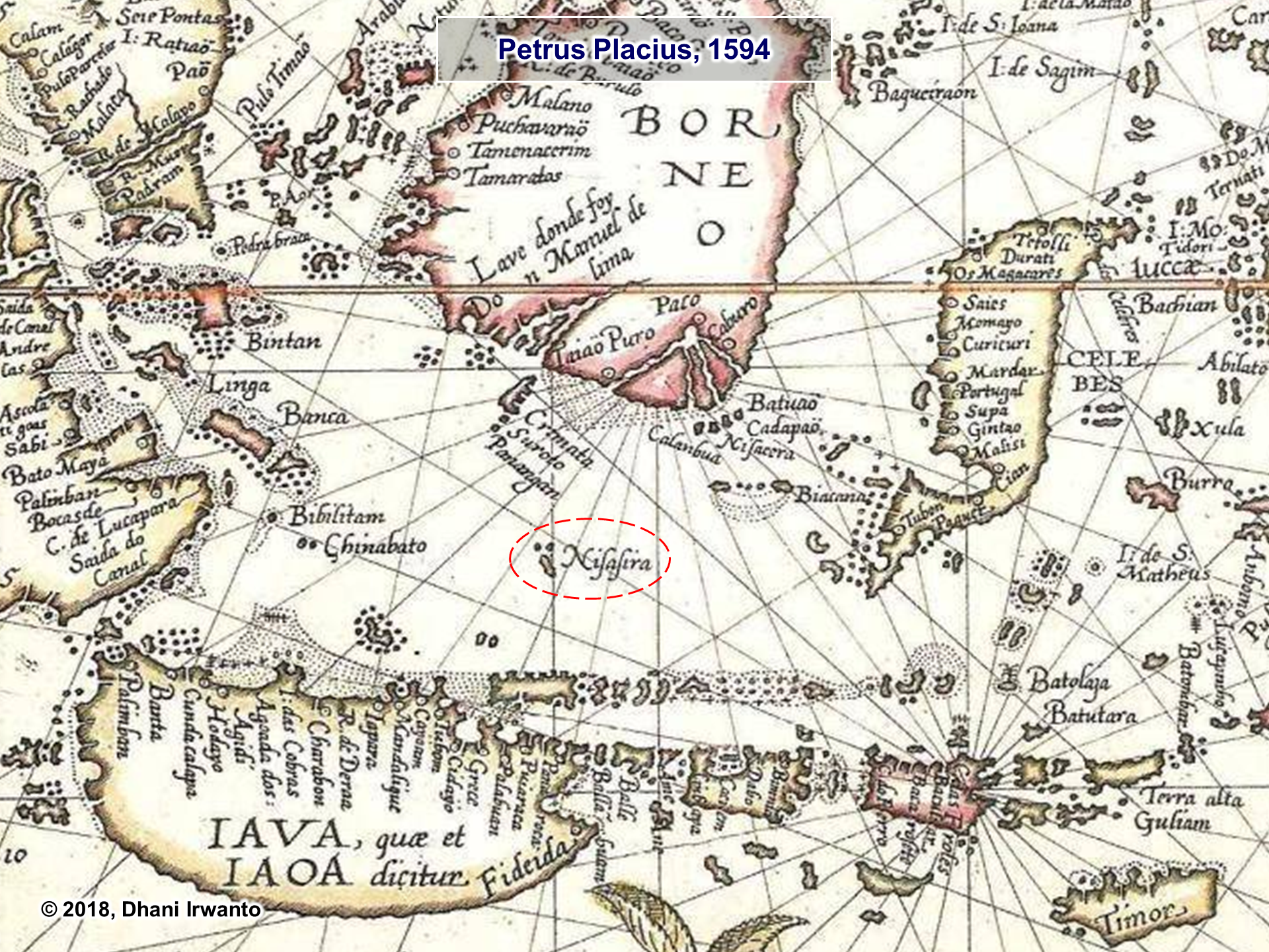
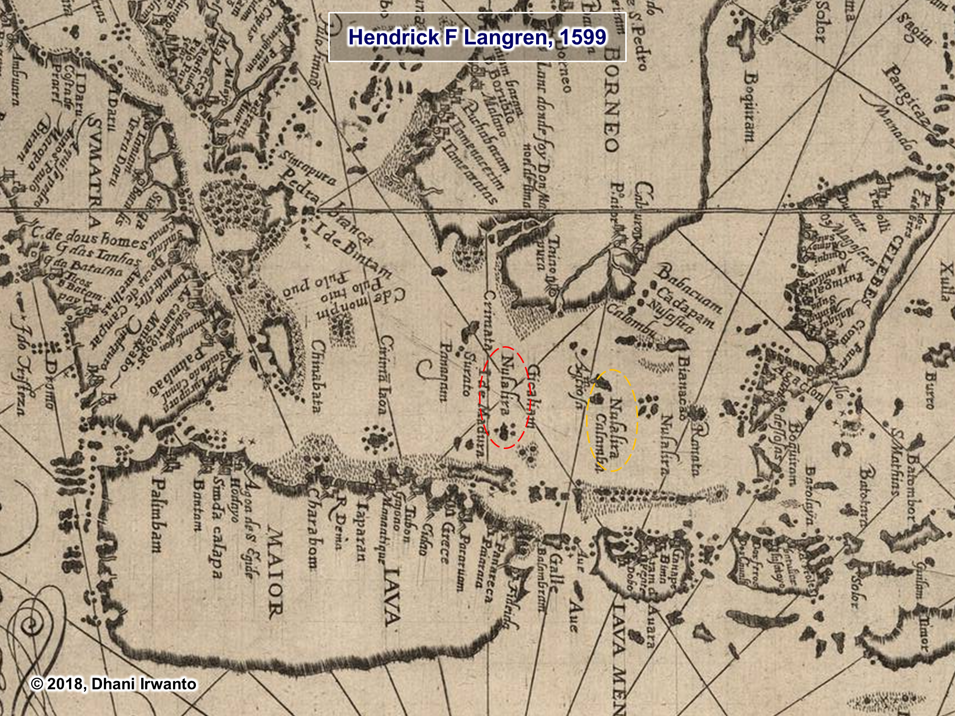
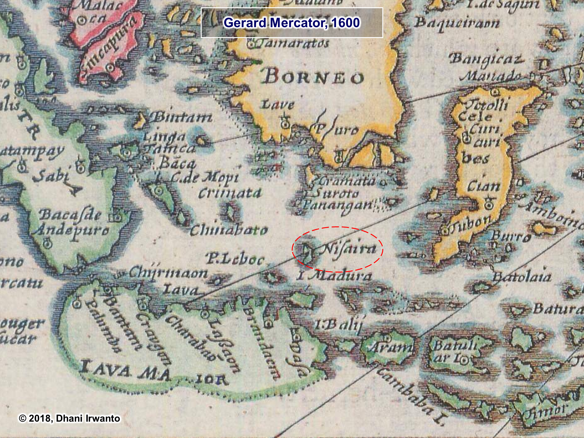
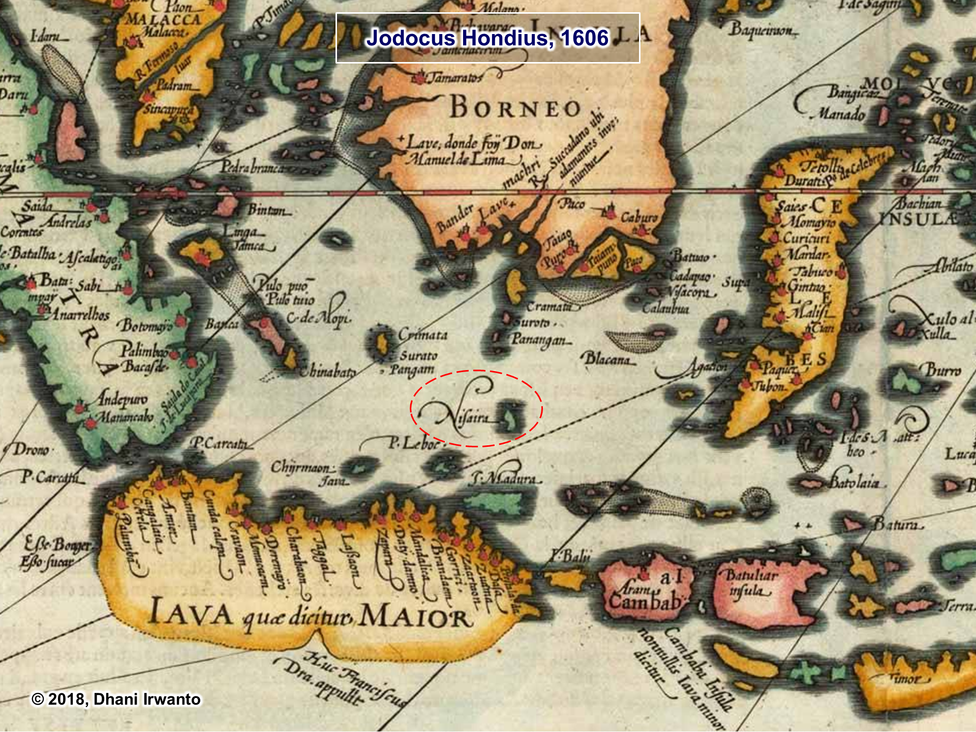
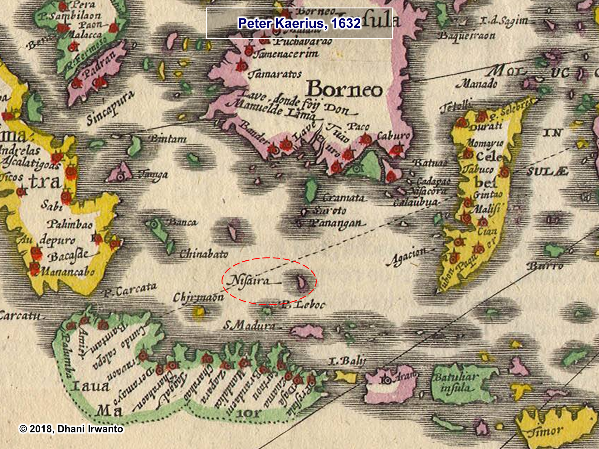
After returning from the island, I thought about opening up the old maps composed by geographers from the sixteenth and seventeenth centuries. After I observed, many maps show the existence of an island located in the northeast of the Bawean Island, with various names such as Nusasua, Nisasira, Nusasira and Nisaira (see attached maps). Then I interpreted the names into Nusasura in the Austronesian language group. Is Nusasura the Island of Atlantis?
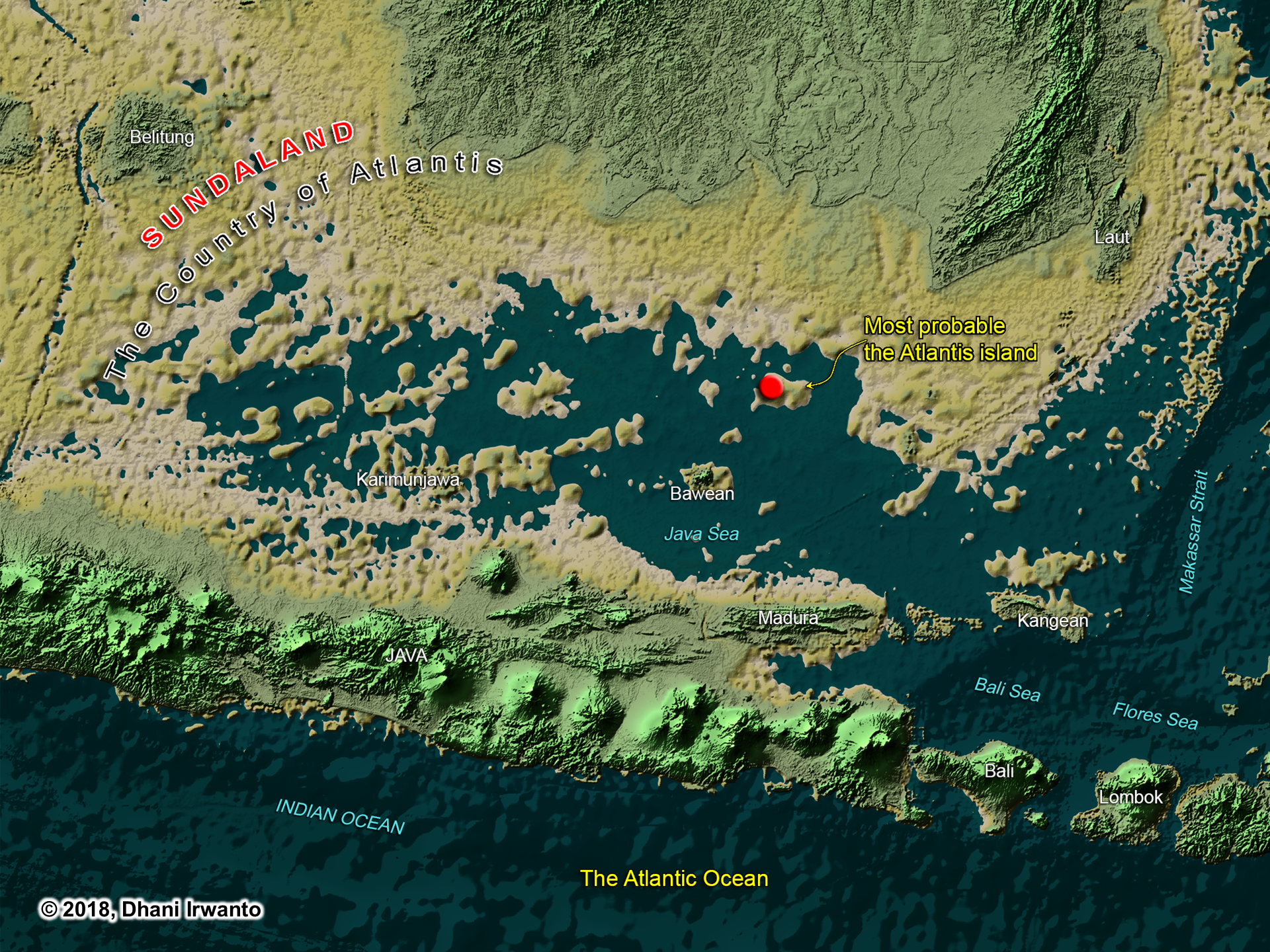
In a research published in 2015, I undertook a hypothesis of the island of Atlantis, where there is the capital city of the kingdom of Atlantis, that is located on the northeast of the Bawean Island. The island is now drowned and overgrown by a coral reef named Gosong Gia or Annie Florence Reef. This coral reef was mapped in detail using multi-beam echosounder some time ago. From the pattern of the coral reef, the structure of the city and its dimensions narrated by Plato can still be seen. The location of the coral reef is more or less the same as the Nusasura shown on the above maps. Please note that the authors of the maps were informed by European sailors who sailed in the Java Sea. The sailors obtained the information about the islands in the Java Sea from the local residents or sailors, who probably also told of the mysterious island and then it was described by the European sailors.
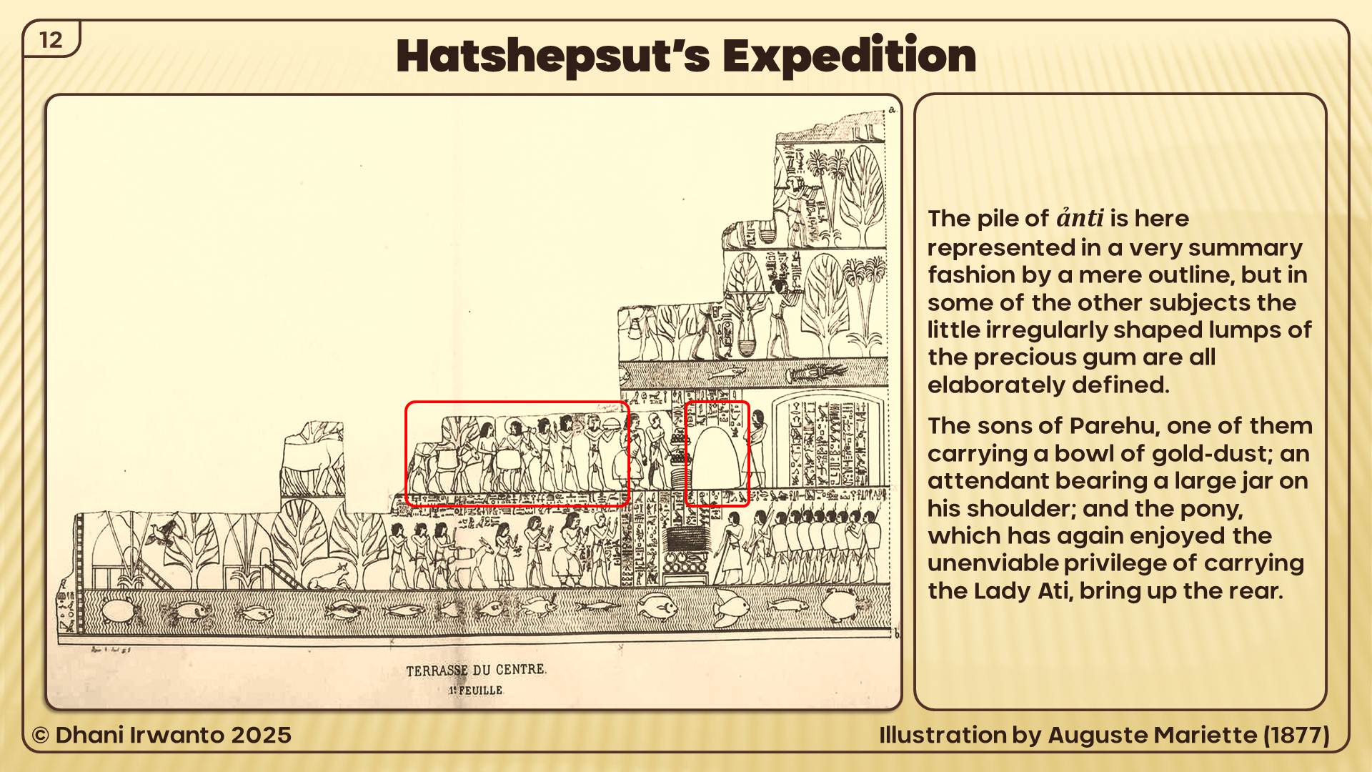
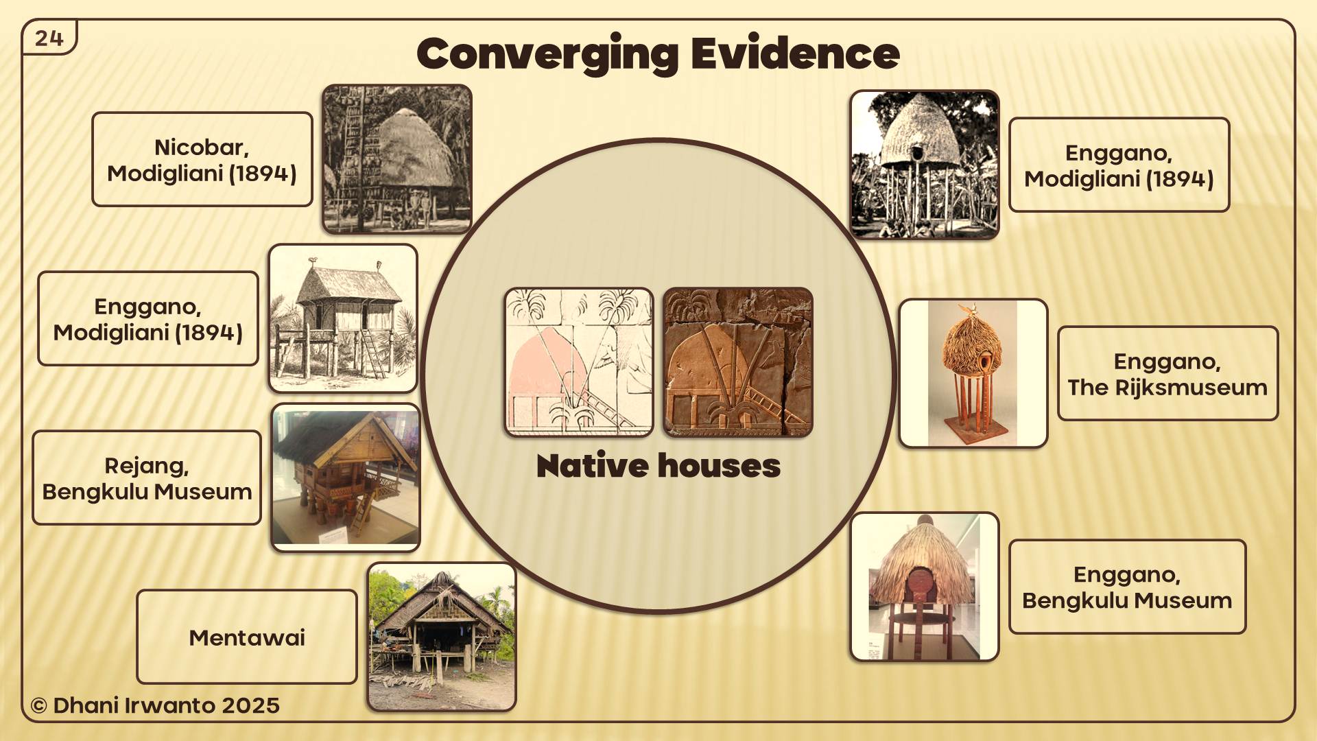
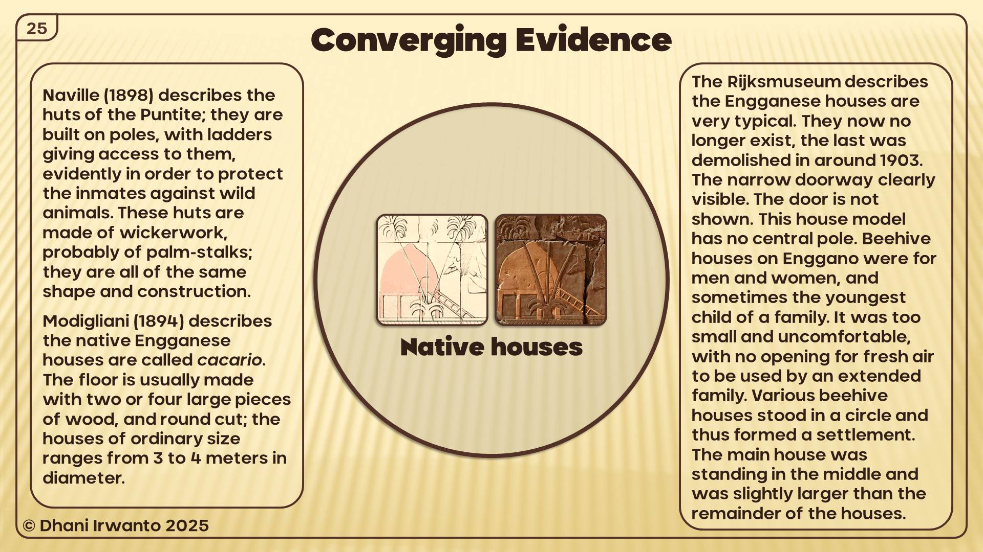
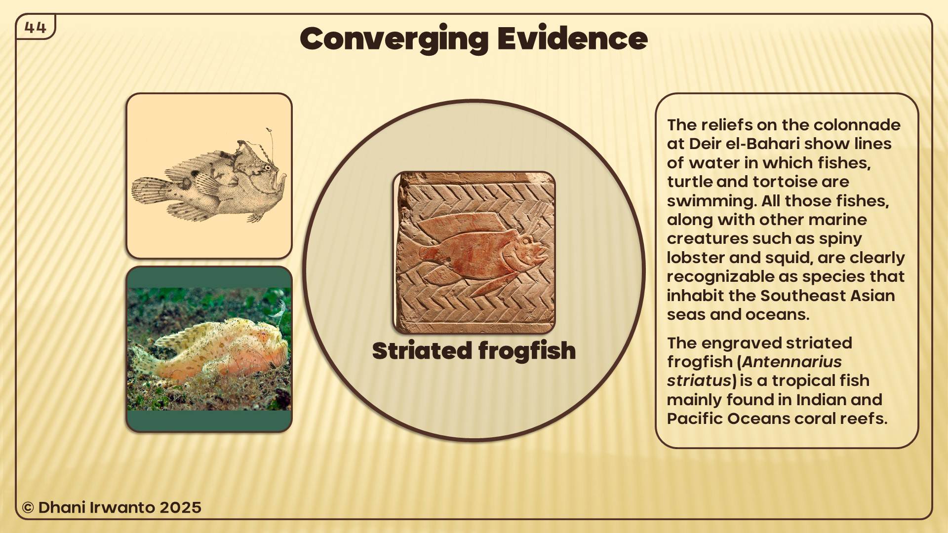
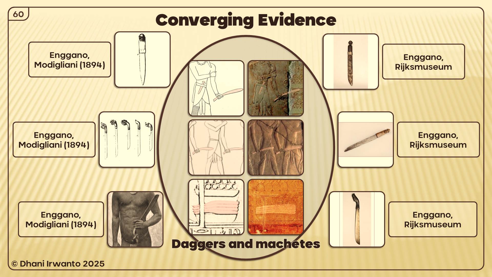
Furthermore, I also observed the ancient records contained in Egypt. From here I obtained a word that sounds like Nusasura, Neserser. In the mythology of the Ancient Egyptians, the island and the lake of Neserser, “the island and the lake of flames” (in the volcanic region) where Osiris and Thoth came from, is often mentioned in their myths. As described in the Papyrus of Nu (in the Book of Dead), the myth tells that Osiris has his throne on the island of Neserser in the center of six or seven concentric circles with a gate at each and they are all in the “lake” of Neserser. The concentric circles were built for Ra by the dwellers of the lake. Thoth had his lands around the lake and he visited Osiris on the island. There was a great flood in the lake of Neserser and somehow these circles of Ra became hidden.
As written in many tomb texts from the Middle Kingdom and the Second Intermediate Periods in the Ancient Egypt, in the concepts of the divinities and the deceased, the Neserser island is a heaven-like place, a place where judgement is passed and the deceased is reborn equipped with a status (god or common being). The Hetep-fields is a kind of paradise under the supervision of the god Hetep with whom the deceased identifies himself, and where he leads the happy life reserved for the privileged. In the concept, Osiris, Horus and Thoth were given the status of gods or ancestral divinities.
The description of Neserser is resemblant to the story of Atlantis.
Six or seven concentric circles were built for Ra on the island of Neserser, conforming to the Atlantis’ four circles of lands (including the central land) and three circles of water, built by the god Poseidon.
Either Osiris or Atlas have their thrones on the central lands.
The lake of Neserser is conforming to the almost closed sea around the Atlantis capital island. Plato describes the sea as a water with a mouth to the outer sea, thus arbitrarily can be called a lake. As described above, I made a hypothesis in 2015 that the sea is the ancient Java Sea where it had only one outlet.
There was a great flood in the lake of Neserser which devastated the island of Neserser, and then it was hidden. This is also in conformity with the descriptions about the destruction of Atlantis.
Again, a sound-like word of Nusasura, Nisir, is also found on the Mesopotamian clay tablets, the name of a sea where Gilgamesh sets out on a series of journeys to search for his ancestor Utnapishtim that has been given eternal life. In 2016, I made a hypothesis that the Epic of Gilgamesh fit the conditions in Indonesia, from the descriptions such as full of noisy birds and cicadas, and monkeys scream and yell in the trees.
Nusasura could have come from the words “nusa” and “asura”, meaning the island of the Asuras. Asuras (also known as Suras and Asuryas) in the dharmic mythology are a class of divine beings or power-seeking deities. Asuras are described as powerful superhuman demigods with good or bad qualities. The good Asuras are called Adityas and are led by Baruna, while the malevolent ones are called Danavas and are led by Vritra. In later Vedic and post-Vedic texts, the benevolent gods are called Devas, while malevolent Asuras compete against these Devas and are considered “enemy of the gods”. In the above Atlantis hypothesis, I made an analogy of the god Baruna with Poseidon, the founder of Atlantis.
The term Asura is linguistically related to the Ahuras of Indo-Iranian people and pre-Zoroastrianism era. In both religions, Ahura, Vouruna and Daeva of pre-Zoroastrianism (Asura, Baruna and Deva of Dharmism) are found, but their roles are on opposite sides. That is, Ahura evolves to represent the good in pre-Zoroastrianism, while Asura evolves to represent the bad in Vedic religion, while Daeva evolves to represent the bad in pre-Zoroastrianism, while Deva evolves to represent the good in Vedic religion. This contrasting roles have led some scholars to deduce that there may have been wars in proto-Indo-European communities, and their gods and demons evolved to reflect their differences. In the Atlantis context, there was a war between Atlantis and “the Athens” (a borrowed name). The Asuras/Ahuras could be analogous to the Atlantean while the Devas/Daevas were “the Athenian”.
Please notice also the linguistic resemblance between Asura and Osiris in the above ancient records of Egypt. Osiris or Atlas have their thrones on the central lands. Note that Osiris was originally the god of water and vegetation. Therefore we can speculate that Asura, Osiris and Atlas are the same person. The name Atlantis was derived from Atlas, Neserser from Osiris and therefore Nusasura from Asura.
Phonetically, Asura is similar to Ashur, the chief god of the Assyrian pantheon, god of military prowess and empire, and namesake of the Assyrian Empire. Some scholars have claimed that Ashur was represented as the winged sun that appears frequently in Assyrian iconography. One variation contain a winged disc with horns, enclosing four circles revolving round a middle circle. The Zoroastrian’s Ahura also have similar representation. From the characters he owns, that are powerful, mighty and has the symbol of solar disc, Ashur could be the association of Asura in the Mesopotamian culture. The circles inside the disc have similar configuration with the land-and-water circles of Atlantis.
In Timaeus Section 24e Plato describes that the country of Atlantis was larger than Libya and Asia Minor put together, and was the way to other islands, and from these you might pass to the whole of the opposite continent which encompasses the true ocean.
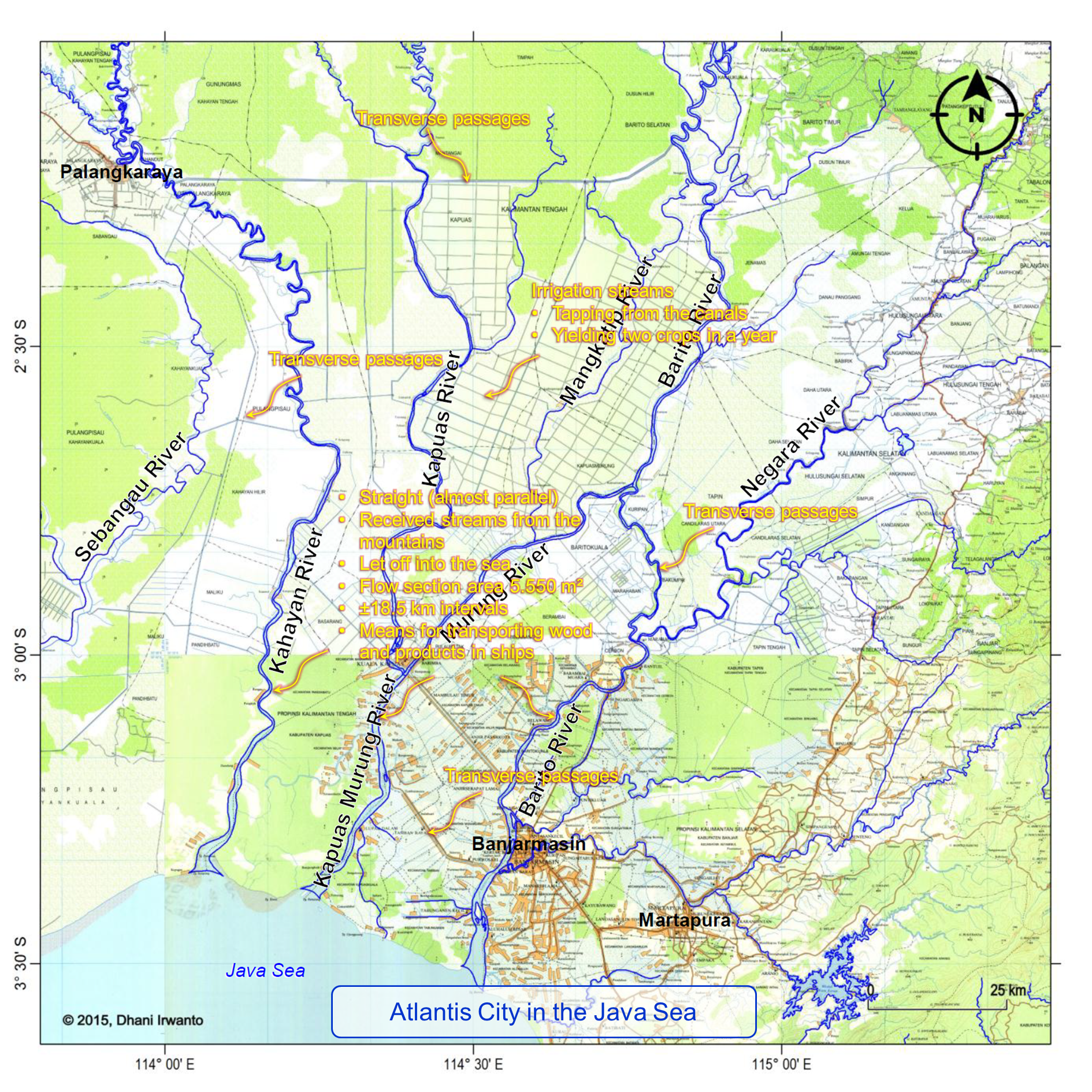
Plato describes the Atlantis Plain plain was level, surrounded by mountains which descended towards the sea, smooth and even, rectangular and oblong shaped, three thousand stadia (about 555 kilometers) long, two thousand stadia (about 370 kilometers) wide, looked towards the south, sheltered from the north, surrounded by mountains celebrated for their number, size and beauty; and had wealthy villages of country folk, rivers, lakes, and meadows.
There were four kinds of channels: the circular (perimeter) ditch, the inland channels, the transverse passages and the irrigation streams. The perimeter ditch was artificial, 100 feet (about 30 meters) deep, 1 stadium (about 185 meters) wide, 10,000 stadia (about 1,850 kilometers) long, carried round the whole plain, received streams from the mountains, winding around the plain, meeting at the city and let off into the sea. The inland canals were straight, 100 feet (about 30 meters) wide, 100 stadia (about 18.5 kilometers) intervals, let off into the perimeter ditch and as means for transporting wood and products in ships. The transverse passages were cut from one inland canal into another. The irrigation streams tapping from the canals were meant to irrigate the land in the summer (dry season) while in the winter (rainy season) had the benefit of the rains.
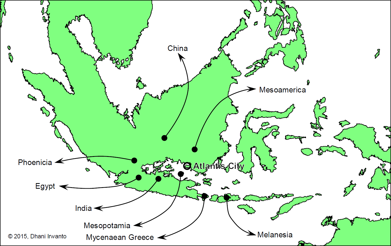
The author conjectures the origins of post-deluge civilizations of Atlantis as shown on the figure below. What did they bring?
Conjecture of origins of post-deluge civilizations
1. Civilization – As written by many authors, humanity was first flourished in Sundaland where ideal climatic conditions for development were found, and it was there that they invented farming, agriculture, trading and civilization.
2. Language – Scholastic belief by etymologists and linguists are positive that all world languages sprang from a common source. Paleo-Sanskrit is one of the theories that it is the ancestor of Sanskrit, Indo-Iranian, Indo-European, Mesoamerican, Sino-Tibetan, Austronesian and all other languages of the world.
3. Myths and doctrines – All the gods and goddesses of various world religions are parallel. Similar myths of great floods, creation and heaven are found all over the world. Brahma, Abram, Avram, Abraham and Ibrahim are believed by some as the same person.
4. Pyramid building – There are hundreds of pyramids still standing all over the world. Cultures separated by oceans, who supposedly never discovered each other’s existence, built these giant triangular structures, aligned them to cardinal directions, encoded within them sacred geometry/math, and used them as sepultures. The Gunung Padang pyramid in West Java, Indonesia dated 23,000 BC or earlier is claimed to be the earliest one.
5. Boat and ship building – Boat and ship have been the instrumental in the development of civilization, affording humanity greater mobility than travel over land, whether for trade, transport or warfare, and the capacity for fishing. Similarities among boat and ship building technology in the Austronesian and other parts of the world were observed. The earliest seaworthy boats may have been developed as early as 40,000 years ago, according to one hypothesis explaining the habitation of Melanesia and Australia.
Arysio Nunes dos Santos (1937 – 2005 AD), was a highly qualified engineer with many patents to his credit. He was Professor of Nuclear Engineering at the Federal University of Minas Gerais in Brazil, and had also worked as a geologist and climatologist. He was also an amateur linguist who had mastered Greek and Sanskrit among others. Apart from his professional interests, Santos has written on a diverse range of subjects including Symbolism, Alchemy, the Holy Grail and Comparative Mythology and Religion. His studies led him to conclude that Atlantis and the biblical Eden were the same and more controversially that it had been located in the area of the Indian Ocean and the South China Sea.
Photo credit: Antonio Roberto dos Santos
Professor Santos explains his idea on Atlantis using infinitude of arguments, which range from the strictly scientific (such as geology, linguistics, and anthropology) to the more arcane and occult ones. Being the first one to ever link the catastrophic events of the end of the last Ice Age (11,600 years ago) with the world-wide traditions of the universal flood and the destruction of Atlantis, Professor Santos managed to find a perfect site for the location of the Lost Continent. Such site strives unrivaled as being the most logical one ever proposed, matching all the features mentioned by the Greek philosopher Plato, as well as those cited by other sources.
In 2005 his ideas were fleshed out by Frank Joseph Hoff and published in book form titled Atlantis: The Lost Continent Finally Found. Santos passed away just weeks after it was launched. Since then his ideas have since remained confined to his archives, precluding any further study or development.
Building on the foundation of Professor Santos’s idea, a hydro expert Dhani Irwanto conducted his own research, leading him to a compelling new theory about the location of Plato’s lost city. In his 2015 book, Atlantis, the Lost City is in the Java Sea, Irwanto presents a detailed and coherent theory, complete with a unique class of evidence to support his findings. He is the first person to compile sufficient evidence to propose a specific location for Atlantis in the Java Sea, off the southern coast of Kalimantan. Drawing on his professional expertise, Irwanto also meticulously analyzes Plato’s many references to the waterways of the Atlantean capital and its extensive plain.
Santos’ Idea on Atlantis
Much exactly like Plato indicated, Atlantis was a real story. Plato’s Atlantis description and its history were based on facts. Professor Santos studies involved the production of a great number of articles and books that may shed some light to the scientists and scholars that become interested in the “occult” story of Atlantis. Before taken as a legend, for the most sure, being a very real story.
Professor Santos had a completely new idea that Atlantis could not be found because everyone had been looking in the wrong place and that Plato’s work on the subject had been misunderstood. He claims that the true location of Atlantis was in the area of the Indian Ocean and the South China Sea. The Indonesian islands are all that is left of it.
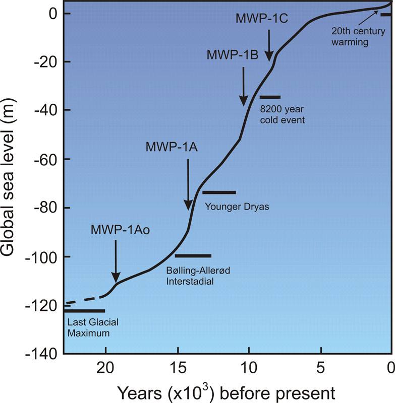
It was in Indonesia and the neighboring lands that man, after emigrating from the semi-deserted savannas of Africa, first found the ideal climatic conditions for development, and it was there that he invented agriculture and civilization. All this took place during the Pleistocene, the last of the geological eras, which ended a scant 11,600 years ago. Though long by human standards, this is but a brief moment in geological terms.
The Pleistocene – a name which is Greek for “most recent” – is also called Anthropozoic Era or Quaternary Era or, yet, the Ice Age. During the Pleistocene and, more exactly, during the glacial episodes that happened at intervals of about 20 thousand years, sea level was about 100 – 150 meters below the present value. With this, a large coastal strip – the so-called Continental Platform (with a width of about 200 kilometers) – became exposed, forming land bridges that interconnected many islands and regions.
The most dramatic of such exposures took place in the region of Indonesia, precisely the spot where humanity first flourished. The vast expansion of the South China Sea then formed an immense continent, indeed “larger than Asia Minor and Libya put together”. This is, as we shall see, precisely what Plato affirms in his discourse on Atlantis, the Critias.
With the end of the Pleistocene Ice Age, the immense glaciers that covered the whole of the northern half of North America and Eurasia melted away. Their waters drained to the sea, whose level rose by the estimated amount of about 100 – 150 meters quoted above. With this rise, Atlantis sunk away and disappeared for good, along with most of its population, which we estimate, based on Plato’s data, at about 20 million people, huge for the epoch in question.
India was one of its nearest and many colonies and that the holy books known as the Vedas and the Hindu religion are based on and in Atlantis. Many other religious ceremonies such as baptism and the others among the seven sacraments of Christianity were memories of Atlantis and how it perished under the seas.
Guanche language was derived from Dravidian and set out a very good case proving this by comparing Dravidian words with those of the Guanche tongue – many are nearly identical. Professor Santos had also written on The Mysterious Origin of the Guanches.
The “Golden Age”, the “Garden of Eden” and the “Paradise” were all memories of Atlantis as it once was and that after its destruction the survivors had to begin again and had lost all their technological advances and were reduced to a very primitive way of living. Atlantis was destroyed following a cataclysmic volcanic eruption and tsunami that shook the entire world.
The Atlantic Ocean was seen by the Greeks as all the water surrounding the continents, which is true. The Indian Ocean, on which the theory focuses, was the real “Ocean of the Atlanteans”. It seems that Avienus placed the Hesperides and the island of Geryon, Erytheia, in this ocean. On the other hand, Avienus and other sources claimed that Erytheia was found in the Orient, thus the connection between the Indian and the “original” Atlantic Ocean.
Troy, Thera, and the capital of the Incas were imitations, re-creations of the original capital of Atlantis. Since Atlantis was a group of islands, its location in the Indian Ocean is possible. The area is part of Pacific Ocean’s Ring of Fire (a chain of volcanoes), that is still active nowadays. The area is also prone to calamities such as volcanic eruptions, earthquakes and tsunamis. In conclusion, Plato’s diluvian world could have taken place here.
Another point of interest is the Holy Mountain. Each culture seemed to have one – starting with Golgotha or Mount Calvary from the Bible, or Mount Qaf in Islamism, Mount Olympus in Greece, etc. The sacred mountain idea, just like the capital of Atlantis, points to Atlantis as the source.
Table 1.The Atlantis locations checklist
Source: atlan.org
The East Indies here refers to Indonesia. On his 32-bullet list, Professor Santos also checked the similarities in the climate of Atlantis and the East Indies. Plato states that Atlanteans had two crops a year and a tropical climate, which matches again the Indonesian climate. It is also known that agriculture was started in the Far East over a ten thousand years ago, which proves the abundance of food needed to sustain a civilization large enough to create an army matched only by Plato’s Atlantean army.
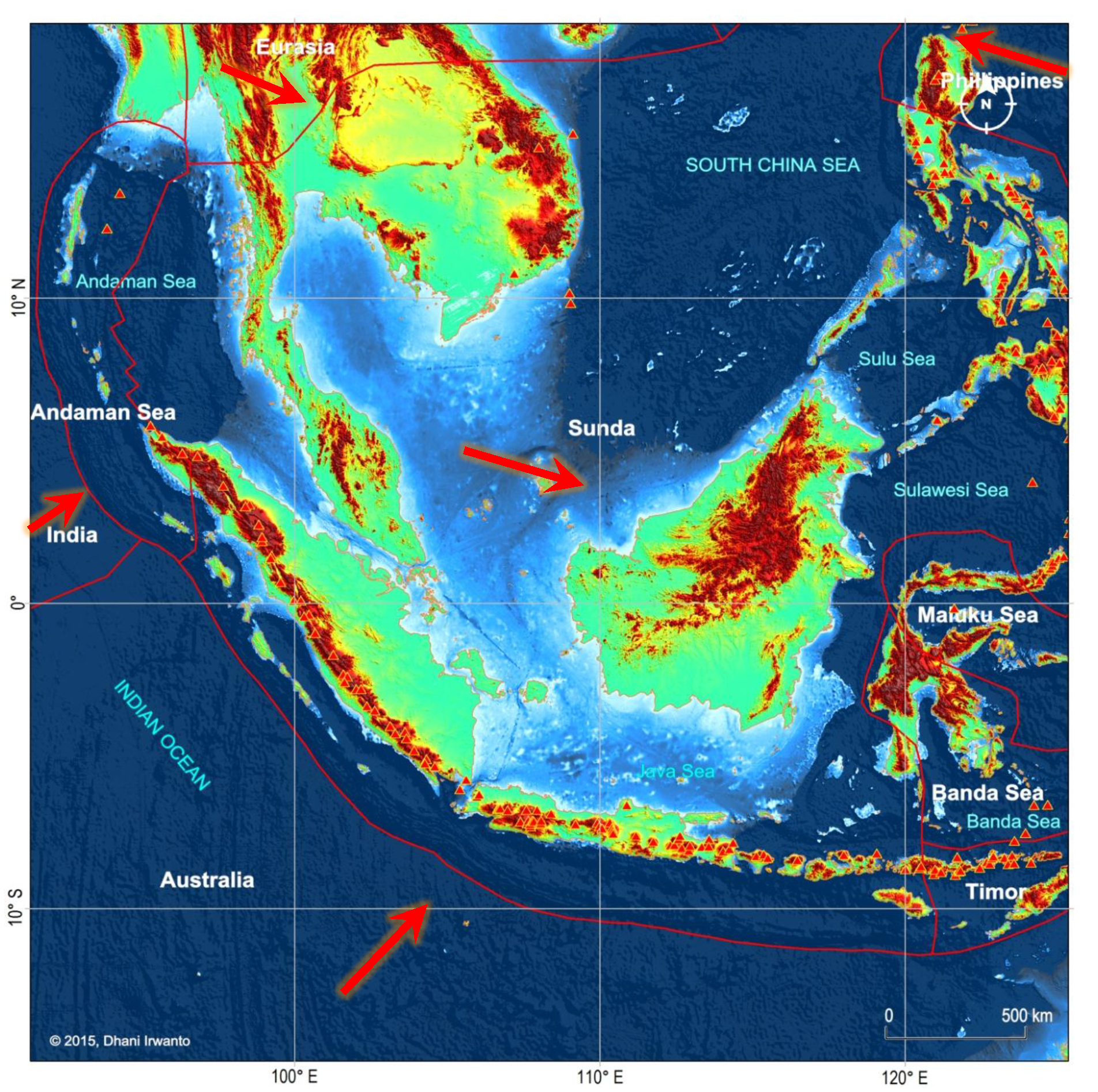
About the Pillars of Heracles – the pillars of Europe (Strait of Gibraltar) were originally called Calpe and Habila, and that the original Pillars were actually the Sunda Strait. The Phoenicians created the confusion between the two different pillars in order to stop the Greeks from reaching the true Paradise.
Atlantis was supposed to lie in the middle of the sea, making the connection between this world and the true continent. Java, Sumatera and the Malay Peninsula are between the Pacific and the Indian Oceans, breaking them in two. It can also be a resting spot for travelers from the continent to the Americas.
Professor Santos’ theory refers to the innavigable seas or the mud barrier. The Strait of Gibraltar always had deep waters, while the Indian Ocean around the islands and peninsulas have murky waters.
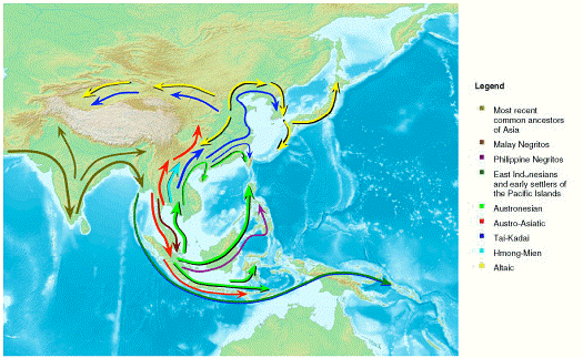
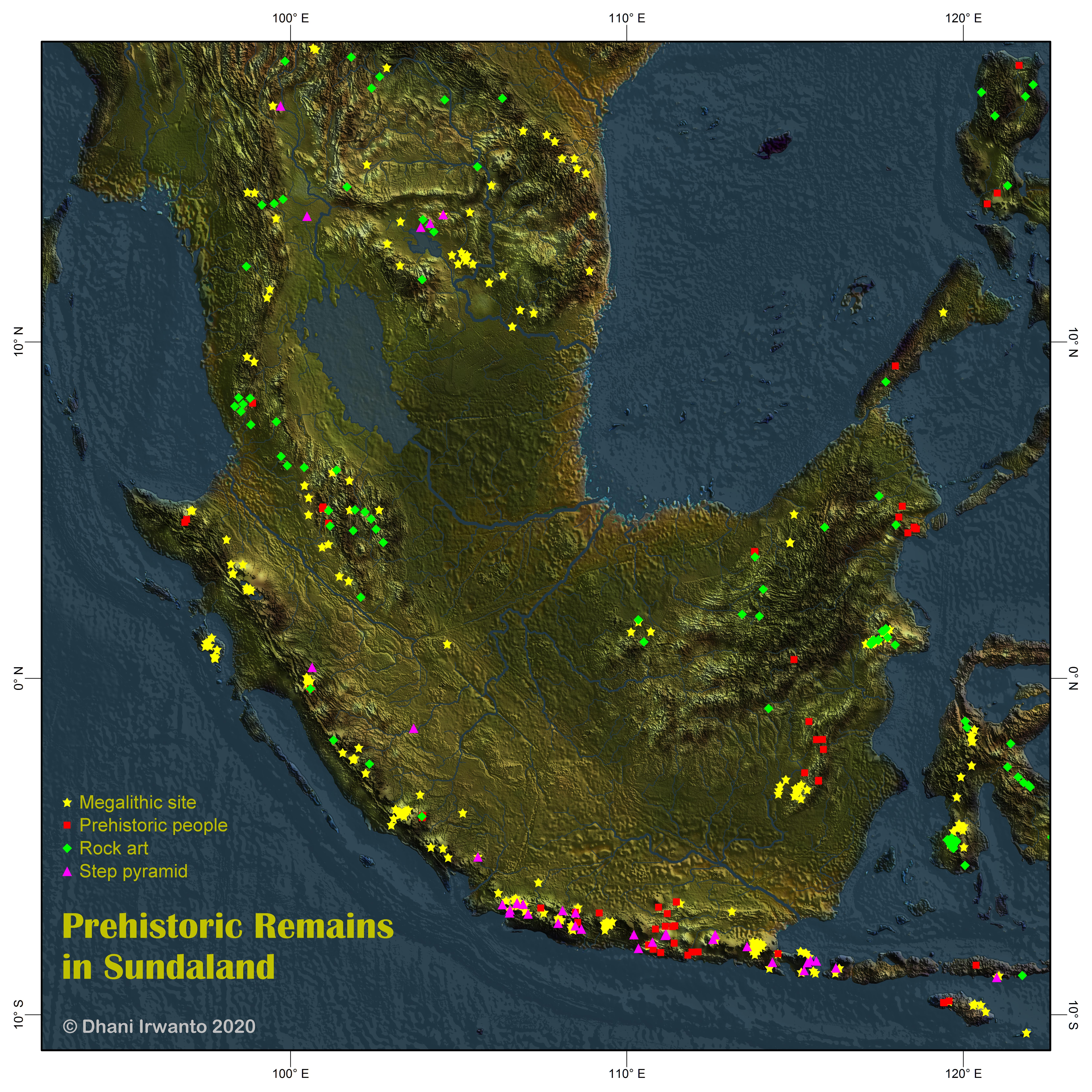
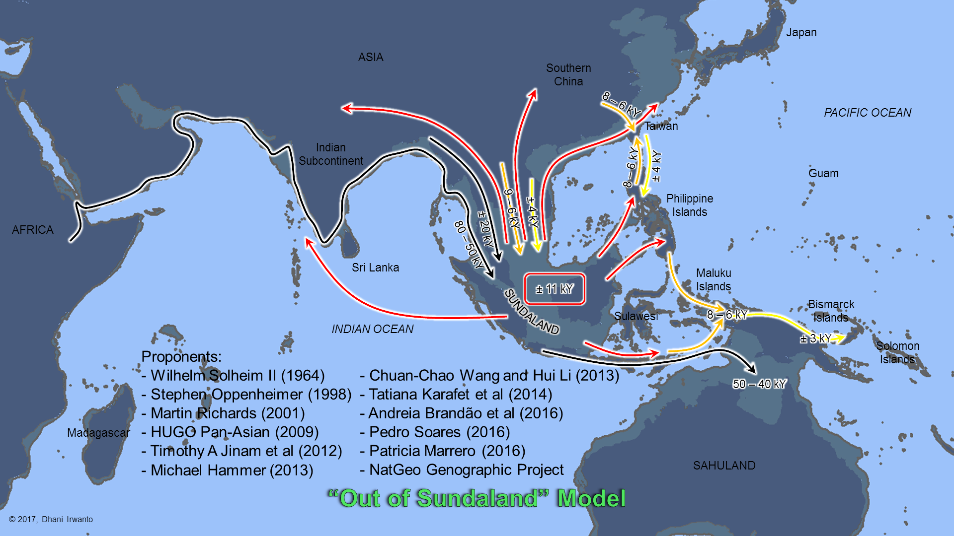
Sundaland: Tracing the Cradle of Civilizations This book presents abundance of indications from archaeological data, genetic studies, legends, myths and tales that Sundaland, a bio-geographical region of Southeastern Asia that was exposed during the Last Glacial period, is the cradle of human civilizations. Read or download book: Google Books, Google Play, archieve.org The paperback is available at Amazon.
Sundaland is a bio-geographical region of Southeastern Asia which encompasses the Sunda shelf, the part of the Asian continental shelf that was exposed during the last Ice Age. The last glacial period, popularly known as the Ice Age, was the most recent glacial period within the current Ice Age occurring during the last years of the Pleistocene, from approximately 110,000 to 12,000 years ago. It included the Malay Peninsula on the Asian mainland, as well as the large islands of Kalimantan, Java, and Sumatera and their surrounding islands. The eastern boundary of Sundaland is the Wallace Line, identified by Alfred Russel Wallace as the eastern boundary of the range of Asia’s land mammal fauna, and thus the boundary of the Indomalaya and Australasia ecozones. The islands east of the Wallace line are known as Wallacea, and are considered part of Australasia. It is worth noting that it is now generally accepted that South East Asia was probably the entry point of modern humans from Africa.
The name “Sundaland” was first proposed by van Bemmelen in 1949, followed by Katili (1975), Hamilton (1979) and Hutchison (1989), to describe the continental core of Southeast Asia forming the southern part of the Eurasian plate. Sundaland is bordered to the west, south and east by tectonically active region characterized by intense seismicity and volcanic activity. The tectonically active zone is effectively a mountain belt in the process of formation, and contain many of the features typically thought to be associated with accretionary orogens: there is active subduction, transfer of material at plate boundaries, examples of collision with buoyant feature on oceanic plates, arcs and continents, and abundant magmatism.
The present orogenic belt is situated at the junction of three major plates: the Eurasian, Indian, Australian and Pacific-Philippine Sea plates. It surrounds Sundaland and stretches from Sumatera to The Philippines via eastern Indonesia. It changes character and width from west to east and is composed of different segments or sutures with different character.
Figure 1 – Sundaland mapat the Last Glacial Maximum (LGM)
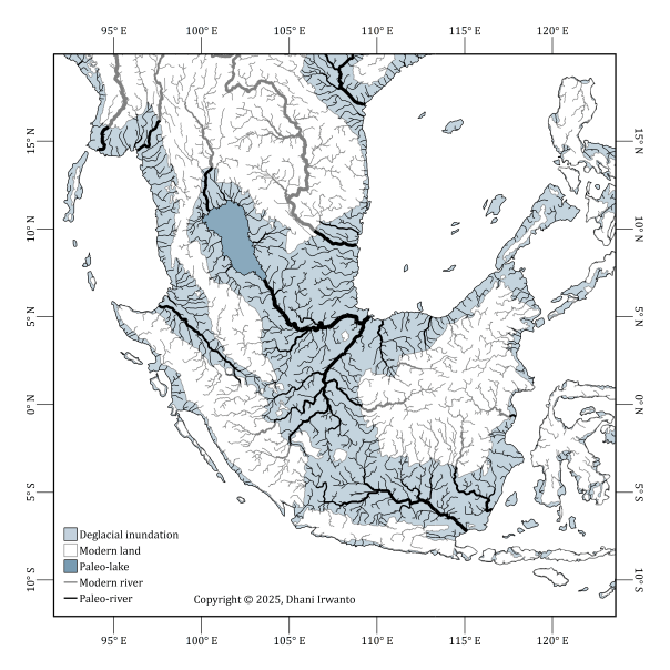
The South China Sea and adjoining landmasses had been investigated by scientists such as Molengraaff and Umbgrove, who had postulated ancient, now submerged drainage systems. These were mapped by Tjia in 1980 and described in greater detail by Emmel and Curray in 1982 complete with river deltas, floodplains and back swamps. The ecology of the exposed Sunda Shelf has been investigated by analyzing cores drilled into the ocean bed. The pollens found in the cores have revealed a complex ecosystem that changed over time. The flooding of Sundaland separated species that had once shared the same environment such as the river threadfin (Polydactylus macrophthalmus, Bleeker 1858; Polynemus borneensis, Vaillant 1893) that had once thrived in a river system now called “North Sunda River” or “Molengraaff River”. The fish is now found in the Kapuas River on the island of Kalimantan, and in the Musi and Batanghari rivers in Sumatera.
The last glacial period, popularly known as the Ice Age, was the most recent glacial period within the current ice age occurring during the last years of the Pleistocene, from approximately 110,000 to 11,600 years BP. The most extensive glaciation in the last glacial period was about 21,000 years ago. Scientists consider this Ice Age to be merely the latest glaciation event in a much larger ice age, one that dates back over two million years and has seen multiple glaciations.
During this period, there were several changes between glacier advance and retreat. The maximum extent of glaciation within this last glacial period was approximately 22,000 years BP. While the general pattern of global cooling and glacier advance was similar, local differences in the development of glacier advance and retreat makes it difficult to compare the details from continent to continent.
From the point of view of human archaeology, it falls in the Paleolithic and Mesolithic periods. When the glaciation event started, Homo sapiens were confined to Africa and used tools comparable to those used by Neanderthals in Europe and the Levant and by Homo erectus in Asia. Near the end of the event, Homo sapiens spread into Europe, Asia, and Australia. The retreat of the glaciers allowed groups of Asians to migrate to the Americas and populate them.
Figure 2 – Post-Glacial sea level (NASA 2012)
Figure 2a. Extended Sundaland adjusted sea-level curve (0–22.5 ka BP). Beyond 19.25 ka, the curve was spliced to the Lambeck et al. (2014) global mean using a constant residual equal to the fitted offset at 19.25 ka, ensuring a seamless join without extrapolation. (Irwanto, 2025)
Figure 2b. Sundaland land area vs. time (22.5–0 ka BP)(Irwanto, 2025)
Figure 2c. Inundation rate vs. time (22.5–0 ka BP)(Irwanto, 2025)
Figure 2d. Land-loss at 15.0, 11.6, 8.0 and 6.0 ka BP(Irwanto, 2025)
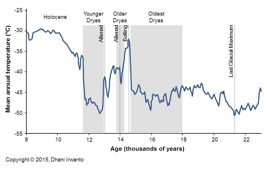
The Younger Dryas stadial, also referred to as the Big Freeze, was a geologically brief (1,300 ± 70 years) period of cold climatic conditions and drought which occurred between approximately 12,800 and 11,600 years BP. The Younger Dryas stadial is thought to have been caused by the collapse of the North American ice sheets, although rival theories have been proposed. It followed the Bølling-Allerød interstadial (warm period) at the end of the Pleistocene and preceded the preboreal of the early Holocene. It is named after an indicator genus, the alpine-tundra wildflower Dryas Octopetala.
The Dryas stadials were cold periods which interrupted the warming trend since the Last Glacial Maximum (LGM) 21,000 years BP. The Older Dryas occurred approximately 1,000 years before the Younger Dryas and lasted about 400 years. The Oldest Dryas is dated between approximately 18,000 and 14,700 BP.
The subdued warming between 14.1 and 12.1 ka BP in Sundaland (Figure 3a) represents a local manifestation of the Younger Dryas, shifted earlier by about one to two millennia. Such displacement may stem from regional feedbacks in the Indo-Pacific Warm Pool (IPWP), where ocean–atmosphere coupling and early resumption of overturning circulation produced a tropical lead relative to Northern Hemisphere cooling (Irwanto, 2025).
Figure 3 – Last Glacial temperature measured from the Greenland ice layers(data from Richard B Alley, 2000)
Figure 3a. Mean Sea Surface Temperature time series for Sundaland (whole boundary) and the inner tropics (±6°), with key climatic intervals highlighted(Irwanto, 2025 based on Osman et al, 2021)
Figure 4 – Last Glacial Maximum temperature animation
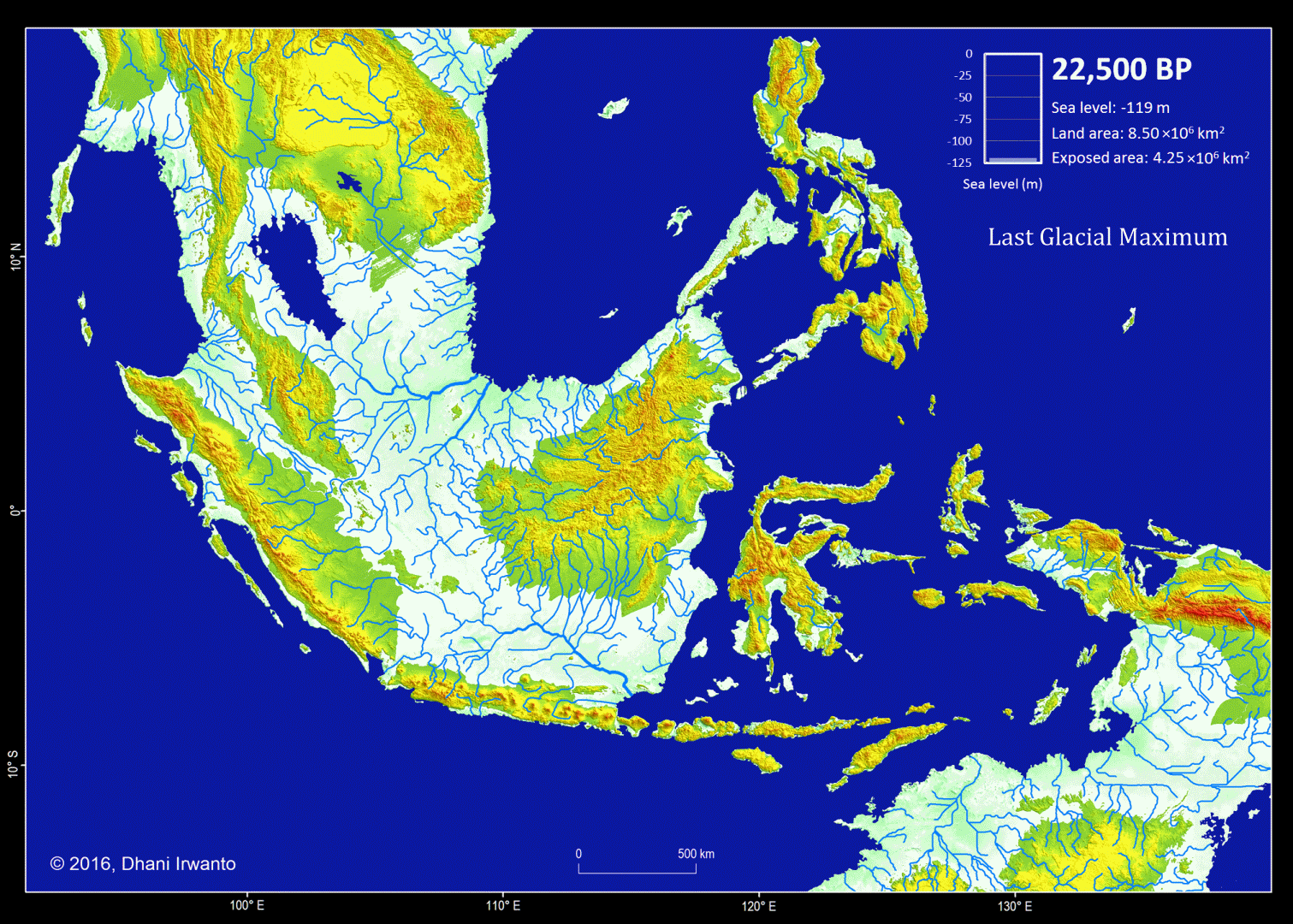
Figure 5 – A map showing the Sundaland around the Last Glacial period (21,000 years BP) generated by the author from the GTOPO30 elevation grids published by USGS. The sea water level was around 120 meter below the present-day sea water level. The flow pattern of the rivers below the present-day sea water level is generated using the same grids and approximations of sea sedimentation, littoral drift, delta formation, meandering, river regime change and river bed movement. The present-day inland rivers are combined. The colors other than blue represent the ground levels. The thin red lines are the present-day shorelines.
Present-day topographic and bathymetric data covering the Sunda Shelf in geographic projection (latitude and longitude) are extracted from the GTOPO30 elevation grids published by USGS. GTOPO30 refers to 30-arc second (approximately 0.9 km near equator) horizontal latitude and longitude spatial resolution of digital elevation model (DEM) file format. Other similar grids like GEBCO_8 published by IHO and IOC/UNESCO, and ETOPO1 published by NOAA are also used as references. A color scheme is applied to the DEM in which areas below -120 m are represented by blue colors so that the Last Glacial Maximum coastlines can be easily identified.
Several assumptions are made in the analytical procedures (Sathiamurthy et al, 2006). First, it is assumed that the current topography and bathymetry of the region approximate the physiography that existed during the span of time from 21,000 years BP to present. However, because sedimentation and scouring processes have affected the bathymetry of the Sunda Shelf over the last 21,000 years (Schimanski and Stattegger, 2005), we know that this is only an approximation. Thus, it should be emphasized that the depth and geometry of the Sunda Shelf and the existing present-day submerged depressions do not reflect past conditions precisely.
Second, it is assumed that the present-day sea bed are likely to have existed during the Last Glacial Maximum and have not resulted from seabed scouring by currents, limestone solution, or tectonic movement-possibilities that were pointed out by Umbgrove (1949) as perhaps taking place during early post-Pleistocene transgression. In the case of tectonic movement, Geyh et al (1979) mentioned that the Sumatera Strait was tectonically stable at least during the Holocene. Furthermore, Tjia et al (1983), state that the Sunda Shelf has been largely tectonically stable since the beginning of the Tertiary. Nevertheless, Tjia et al (1983) indicated that sea level rise in this region may be attributed to a combination of actual sea level rise and vertical crust movement. Hill (1968) in reference to earlier work done by Umbgrove (1949), suggested the possibility of limestone solution as a mode of depression formation (as in the case of the Lumut pit off the coast of Perak, Malaysia), and gave an alternative explanation, which was of tectonic origin.
Sea bed sedimentation data are rarely available but approximation of sedimentation process is made in generating the topographic and bathymetric regional map of Sundaland. In similar conditions, other processes like littoral drift, delta formation, meandering, river regime change and river bed movement are also approximated and incorporated on the maps. Ancient lakes are reconstructed from the DEM and any geological history that exist. Small and insignificant islands are removed.
Along with the topographic and bathymetric map, shorelines at certain sea water levels, ground surface slope, river watersheds and flow pattern of rivers are also generated and place them in different layers.
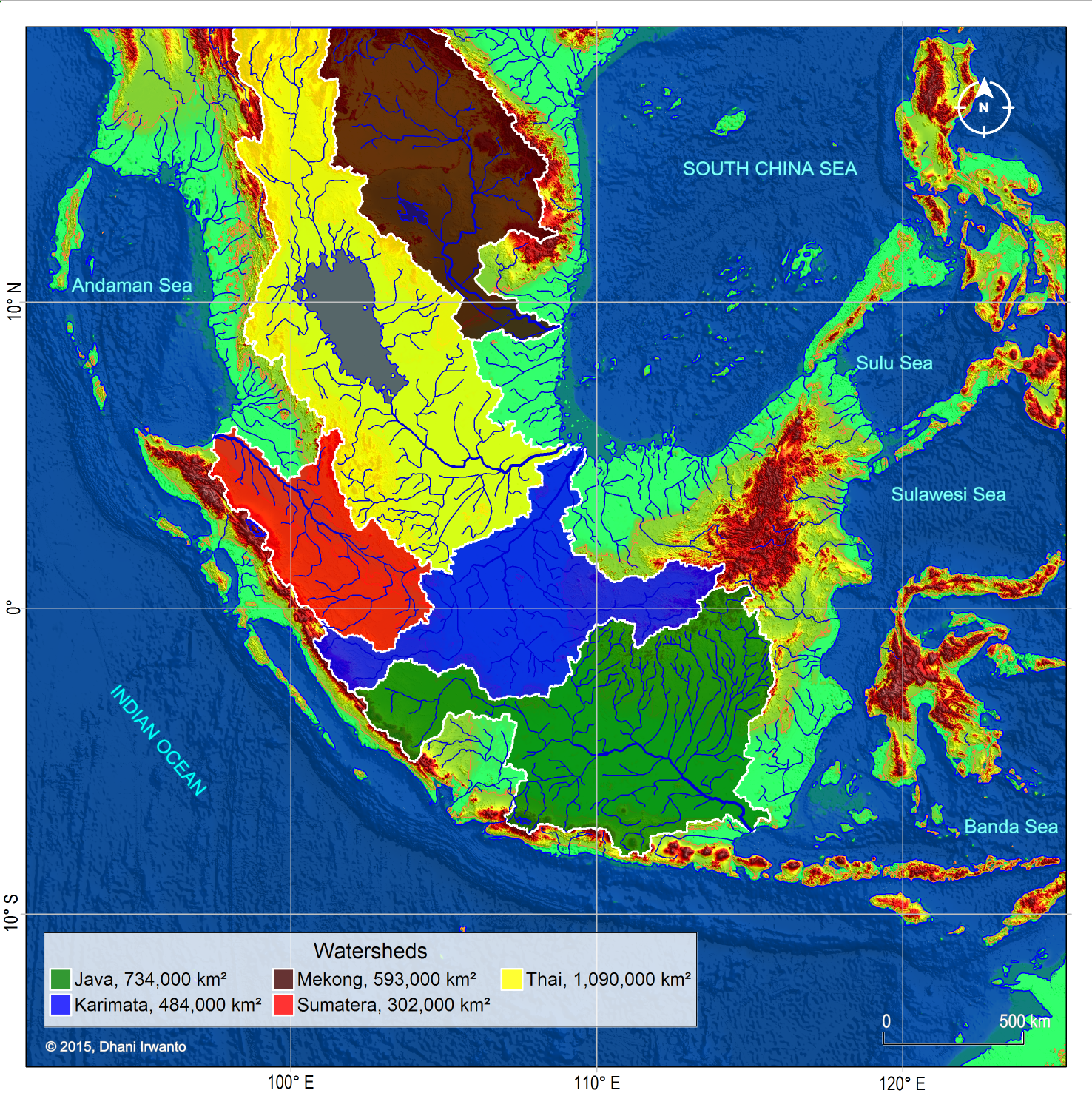
Figure 6 – A map showing the Sundaland major watersheds around the Last Glacial Maximum period (21,000 years BP) generated by the author using the same method as in the previous figures. River names are given referring to the sea, strait, gulf, island or present day river names occupied by the watersheds.
Cannon et al (2009) have done research on the distribution of vegetation in Sundaland during the Last Glacial Maximum using explicit spatial model coupled with the evidence of geography, paleoclimatology and geology. The vegetation is divided into three types, namely coastal/swamp, lowland and highland evergreen rainforests.
Coastal/swamp evergreen rainforests experienced the most dynamic biogeographic history of the 3 forest types examined. At the peak of the Last Glacial Maximum, when sea levels fell below the shelf margin, mangroves were restricted to a very narrow belt along coastlines. However, many coastal swamp taxa would have maintained widespread inland distributions on poorly drained interfluves on watershed or kerapah peats, and in kerangas vegetation, which share many taxa with coastal peat swamp forests. As the shelf began to flood, especially from 11,000 to 9,000 BP, the coastal/swamp evergreen rainforests would have experienced a dramatic but relatively brief expansion. Since about 8,000 BP, coastal forests have roughly remained in their present positions, with the extent of mangroves, freshwater alluvial and peatswamps being determined by the patterns of progradation of individual river deltas following the Holocene transgression. The coastal/swamp evergreen rainforests also experienced a sudden and complete geographic relocation over hundreds of kilometers during the flooding, as the coastline retreated quickly across the shelf, coupled with an equally dramatic change in core area from minimal at the Last Glacial Maximum to maximal at the time of the flooding of Sundaland.
The total area and core area of the lowland evergreen rainforests were substantially greater than current conditions through the vast majority of the last glacial cycle, with the presence of an open corridor of seasonal forest having relatively little impact. The total area and core area of the highland evergreen rainforests experienced a gradual upward trend through the last glacial cycle, with a fairly dramatic peak at the Last Glacial Maximum. In general, the distribution of the highland evergreen rainforests was very sensitive to the interaction between temperature change and vegetation lapse rate.
Figure 7 – Vegetation map of Sundaland at the Last Glacial Maximum based on historical data from Bird et al (2005) with several adjustments, for open (left) and closed (right) corridors (Cannon et al, 2009)
Figure 8 – Main active faults in Sundaland at the zone of convergence of the plates of Sunda, Eurasia, Philippines, India and Australia. Smaller plates of Timor and Banda Sea (part of Sunda), Maluku (part of Philippines) and Andaman (part of Eurasia) are also shown. Large arrows represent absolute motions of plates. Red triangles are the volcanoes.
Figure 9 – Plots of major earthquake occurrences ever recorded and their intensities in Mw scales. Note that Sundaland is encircled by earthquake prone lines. (Source: USGS)
Figure 10 – Plots of tsunami sources ever recorded and their created water heights. Note that tsunamis occurred frequently in Banda Sea and Sulawesi Sea that could affect the inner islands. (Source: NOAA)
Figure 11 – Plots of volcano eruptions ever known and their Volcanic Explosivity Indices (VEI). Note for large scale Tambora eruption in 1815 and frequent Krakatau eruptions being the largest in 1883. (Source: NOAA)
Human Migration Theories
According to the previous theory, the ancestors of the modern day Austronesian populations of the Malay archipelago and adjacent regions are believed to have migrated southward, from the East Asia mainland to Taiwan, and then to the rest of Maritime Southeast Asia. However, recent finding points to the now-submerged Sundaland as the possible cradle of Asian population: thus the “Out of Sundaland” theory.
Figure 12 – “Out of Taiwan” Model
Oppenheimer locates the origin of the Austronesians in Sundaland and its upper regions. Genetic research reported in 2008 indicates that the islands which are the remnants of Sundaland were likely populated as early as 50,000 years ago, contrary to a previous hypothesis (Bellwood and Dizon, 2005) that they were populated as late as 10,000 years ago from Taiwan.
A study from Leeds University and published in Molecular Biology and Evolution in 2008, examining mitochondrial DNA lineages, suggested that humans had been occupying the islands of Southeast Asia for a longer period than previously believed. Population dispersals seem to have occurred at the same time as sea levels rose, which may have resulted in migrations from the Philippine Islands to as far north as Taiwan within the last 10,000 years. The population migrations were most likely to have been driven by climate change – the effects of the drowning of an ancient continent. Rising sea levels in three massive pulses may have caused flooding and the submerging of the Sunda continent, creating the Java and South China Seas and the thousands of islands that make up Indonesia and the Philippines today. The changing sea levels would have caused these humans to move away from their coastal homes and culture, and farther inland throughout Southeast Asia. This forced migration would have caused these humans to adapt to the new forest and mountainous environments, developing farms and domestication, and becoming the predecessors to future human populations in these regions.
The 2009 research and study by the HUGO Pan-Asian SNP Consortium, conducted within and between the different populations in the Asia continent, showed that genetic ancestry was highly correlated with ethnic and linguistic groups. There was a clear increase in genetic diversity from northern to southern latitudes. The study also suggested that there was one major inflow of human migration into Asia arising from Southeast Asia, rather than multiple inflows from both southern and northern routes as proposed before. This indicates that Southeast Asia was the major geographic source of East Asian and North Asian populations. East Asians have mainly originated from South East Asian populations with minor contributions from Central-South Asian groups. The Taiwan aborigines are derived from Austronesian populations. This stands in contrast to the suggestion that this island served as the ancestral “homeland” for Austronesian speaking populations throughout the Indo-Pacific.
Figure 13 – Colored arrows depict the increasing genetic diversification of humans after they migrated eastward along what is now India’s coast and split into numerous genetically distinct groups that moved across Southeast Asia and migrated north into East Asia (Source: HUGO Pan-Asian SNP Consortium)
In 2012, Stephen Oppenheimer pointed out that the genetic, climatic and archaeological evidence logically suggests a single southern exit of modern human from Africa to Sundaland. All non-African groups today are descended from this exit, with the exception of some autosomes (7% or less) apparently derived from admixture with several archaic non-African groups. Whether this exit predated the Toba eruption is currently unclear. A series of founding bottlenecks characterized rapid migration around the Indian Ocean coast to Borneo and Bali at the tip of the Sunda shelf. Then, a sea-level low stand permitted multiple colonizations of the Sahul, followed by prolonged isolation until the post-glacial period, during which maritime gene flow from island southeast Asia recommenced. These last migrations were limited into Australia and substantial into Melanesia. Climate and access to fresh water were crucial determinants of routes and dates for windows of opportunity.
Figure 14 – Map showing single southern route out of Africa and beachcomber arc route from the Red Sea along the Indo-Pacific coast to Australia, including likely extensions to China, Japan and New Guinea. Vegetation and sea level shown as at Last Glacial Maximum (LGM). (Oppenheimer, 2012)
In 2012, Jinam et al determined 86 mitochondrial DNA (mtDNA) complete genome sequences in four indigenous Malaysian populations, together with a reanalysis of published autosomal single-nucleotide polymorphism (SNP) data of Southeast Asians to test the plausibility and impact of those migration models. The three Austronesian groups (Bidayuh, Selatar, and Temuan) showed high frequencies of mtDNA haplogroups, which originated from the Asian mainland 30,000–10,000 BP, but low frequencies of “Out of Taiwan” markers. Principal component analysis and phylogenetic analysis using autosomal SNP data indicate a dichotomy between continental and island Austronesian groups. They argue that both the mtDNA and autosomal data suggest an “Early Train” migration originating from Indochina or South China around the late-Pleistocene to early-Holocene period, which predates, but may not necessarily exclude, the Austronesian expansion.
Karafet et al (2014), through a study of Y-DNA supported the hypothesis of a Southeast Asian/Oceanian center for the diversification of Oceanian K-haplogroup lineages and underscore the potential importance of Southeast Asia as a source of genetic variation for Eurasian populations. The phylogenetic structure of haplogroup K-M526 shows consecutive branching events (M526, P331 and P295), which appear to have rapidly diversified. With the exception of P-P27, all of the descendant lineages are located today in Southeast Asia and Oceania: K-M526*, K-P402, K-P261 and NO are the lineages most closely related to haplogroup K-P331, K-P397 is the sister lineage of P-P295 and the P-P295* lineages are the closest relatives of haplogroup P-P27. This pattern leads to hypothesize a southeastern Asian origin for P-P295 and a later expansion of the ancestor of subhaplogroups R and Q into mainland Asia. Although K-M526 was previously characterized by a single polytomy of eight major branches, the phylogenetic structure of haplogroup K-M526 is now resolved into four major subclades (K2a–d). The largest of these subclades, K2b, is divided into two clusters: K2b1 and K2b2. K2b1 combines the previously known haplogroups M, S, K-P60 and K-P79, whereas K2b2 comprises haplogroups P and its subhaplogroups Q and R.
Interestingly, the monophyletic group formed by haplogroups R and Q, which make up the majority of paternal lineages in Europe, Central Asia and the Americas, represents the only subclade with K2b that is not geographically restricted to Southeast Asia and Oceania. Estimates of the interval times for the branching events between M9 and P295 point to an initial rapid diversification process of K-M526 that likely occurred in Southeast Asia, with subsequent westward expansions of the ancestors of haplogroups R and Q. More interestingly, ancient DNA evidence suggests that haplogroup R1b – the current dominant lineage in western Europe – did not reach high frequencies until after the European Neolithic period as given in Lacan et al and Pinhasi et al.
Figure 15 – Phylogeny of haplogroup K (Karafet et al, 2014)
Figure 16 – The spread of descendants of haplogroup K2 (Karafet et al, 2014)
There has been a long-standing debate concerning the extent to which the spread of Neolithic ceramics and Malay-Polynesian languages in Island Southeast Asia (ISEA) were coupled to an agriculturally driven demic dispersal out of Taiwan 4,000 years ago. Brandão et al in a paper published by the Human Genetics in 2016 addressed this question using founder analysis of mitochondrial DNA (mtDNA) control-region sequences to identify major lineage clusters most likely to have dispersed from Taiwan into ISEA, proposing that the dispersal had a relatively minor impact on the extant genetic structure of ISEA, and that the role of agriculture in the expansion of the Austronesian languages was therefore likely to have been correspondingly minor. They showed that, in total, about 20% of mtDNA lineages in the modern ISEA pool result from the “Out-of-Taiwan” dispersal, with most of the remainder signifying earlier processes, mainly due to sea-level rises after the Last Glacial Maximum. Every one of these founder clusters previously entered Taiwan from China, 6,000 – 7,000 years ago, where rice farming originated, and remained distinct from the indigenous Taiwanese population until after the subsequent dispersal into ISEA.
In 2016, Soares et al from the University of Minho in Portugal as published in the Human Genetics showed a series of much more complicated events. mtDNA and Y-chromosome found in the Pacific Islands have existed in the islands of Southeast Asia much earlier than 4,000 BC, which raises serious doubt on the theory of “Out-of-Taiwan”. They argue that the landscape and the changing sea level about 11,500 years ago led to a significant expansion from Indonesia 8,000 years ago. This expansion, which is the team’s discovery, showed that the population in the whole of Southeast Asia and the Pacific Islands share the same mtDNA and Y-chromosome. The results of the study by the team also showed minor wave of migration that may lead to the spread of Austronesian languages.
Figure 17 – Outline of maternal lineages involved in the main human migrations in the region of Southeast Asia and Taiwan (Soares et al, 2016)
Figure 18 – A map showing sites of pre-historic remains in Sundaland, which consist of megalithic sites, prehistoric peoples, rock arts and step pyramids. Note that the remains are densely found in Java, Bali, southern Sumatera, southern Sulawesi and southern Kalimantan. No undersea remain has been investigated. (Sources: various, collected by the author)
Figure 19 – “Out of Sundaland” Model
Mass Dispersal from Sundaland at the End of the Younger Dryas Period
A mass dispersal from Sundaland was happened around the Younger Dryas period (approximately 12,800 – 11,600 years ago), most probably the end of the period. It was caused by an unknown mega catastrophe as detected from the observation data, a sharp decline of the world population, emergence of many civilizations and the people memories (legends, myths, tales) around the world. The dispersal is also detected by the genetic studies.
Ideal climatic conditions and natural resources for development were found in Sundaland. After migrating from the semi-deserted savannas of Africa, man first found a place where food was abundant and it was there that they invented farming, agriculture, trading and civilization, which made humanity first flourished. All this took place during the Last Glacial period, where the sea level was as low as 120 meters (400 feet) below the present value that caused a vast land of Sundaland to expose.
The glaciers started to retreat and the sea levels continued to rise gradually from the peak levels around 19,000 to about 5,500 years ago. Cracks in the earth’s crust as the weight of the ice shifted to the seas set off catastrophic events. Rapid coastal population loss was compounded by super tsunami waves and super quakes on tropical coasts with flat continental shelves of Southeast Asia. The floods drowned the coastal cultures and all the flat continental shelves, and wiped out many populations. As the sea rolled in, there was a mass migration from the sinking continent at the end of the Younger Dryas period (approximately 11,600 years ago), one of the most well-known examples of such abrupt change.
Recent genetic studies show that there has been a sharp decline in the population of the world beginning in the early Holocene, or the end of the Younger Dryas period, causing a bottle neck of human population. There were population turnovers from Southeast, East and South Asia to Europe, Near East and the Caucasus, suggesting that the end of the Younger Dryas period caused the refugium of those populations to migrate and establish new civilizations. From the archaeological data, the end of Younger Dryas was also marked by the emergence of many civilizations around the world.
The Younger Dryas disasters are also documented as legends, myths or tales in almost every region on Earth, observable with tremendous similarities. They are common across a wide range of cultures, extending back into Bronze Age and Neolithic prehistory. The overwhelming consistency among legends and myths of flood and the repopulation of man from a flood hero similar to the Noah Flood are found in distant parts of the Earth. The myths similar to the Garden of Eden, Paradise or Divine Land echo among the populations around the world. Memories of their origin are documented in their legends, such as the stories of Atlantis, Neserser, Land of Punt, Land of Ophir, Gilgamesh, Kumari Kandam, Kangdez, Tollan and Taprobana. Those indicate that they were derived from a common origin.
With a bulk of collected archaeological and genetic studies as well as legends, myths and tales, the author makes an attempt to reassemble the possible connections of the evidence to obtain the pattern of the population dispersal using a “Potsherd Model”, as shown on the figure below.
Figure 20 – Mass dispersal from Sundaland at the end of the Younger Dryas period
Riverine Civilizations
Rivers supplied a continuous if not always dependable flow and supply of water for transportation, farming and human consumption. These rivers along with climate, vegetation, geography, and topography shaped the development of the early riverine civilizations. However, while people of these civilizations were dependent on the rivers, the rivers also inspired new technological, economic, institutional, and organizational innovations and developments. Riverine cultures were the cradle of maritime civilizations which later developed into Austronesian-speaking people.
Large rivers with fertile lands existed in Sundaland during the Ice Age. It is logical that the civilizations developing in this region began at these riverines. Since the seas were inseparable from their lives, their development until fully developed must happen at the estuarines. Sea level rise and frequent floods or tsunamis caused some of them to move to higher ground, on mountains. Rivers are the only means of transportation existed at that time, so they moved along the rivers in the upstream direction. Ancient civilizations survive to this day have been observed and it turns out that they are living in regions upstream of major rivers.
Figure 21 – Riverine civilizations in Sundaland
Ancient riverine cultures are evidenced by rock paintings spread allover the archipelago. Most of the paintings are estimated more than 10,000 years old. Some of the paintings depict boats. These suggest that they already had the technology from the very ancient time. The ones in Maros were carbon dated to about 40,000 years old.
Figure 22 – Rock paintings depicting boats
Domestications
Recent studies have revealed the presence of several agricultural crops and animals domesticated in Sundaland and its surroundings and they are closely related to population distributions from Sundaland. However, these studies are limited to discoveries available at this time only. The domestications are inseparable from the water environments, either rivers or seas which met at the estuaries. Thus it can be assumed that the early civilizations were centered at the estuarines, as discussed before.
However, most Ice Age estuarines in Sundaland are presently under the sea. We can presume that the evidence of the oldest domestications are not discovered due to their locations under the sea and those are discovered today are on higher grounds which are so much younger. Additionally, Sundaland has had frequent volcanic activities resulted in thick layers of volcanic ash, to become serious obstacles to discover such archaeological evidence.
Coconuts
DNA analysis of more than 1,300 coconuts from around the world by Olsen et al (2011) reveals that the coconut was brought under cultivation in two separate locations, one in the Pacific basin and the other in the Indian Ocean basin (Baudouin et al, 2008; Gunn et al, 2011). What’s more, coconut genetics also preserve a record of prehistoric trade routes and of the colonization of the Americas. In the Pacific, coconuts were likely first cultivated in island Southeast Asia, meaning the Philippines, Malaysia, Indonesia, and perhaps the continent as well. In the Indian Ocean the likely center of cultivation was the southern periphery of India, including Sri Lanka, the Maldives, and the Laccadives. The Pacific coconuts were introduced to the Indian Ocean a couple of thousand years ago by ancient Austronesians establishing trade routes connecting Southeast Asia to Madagascar and coastal east Africa.
In the book Eden in the East (1998), Stephen Oppenheimer claims that the domestication of rice was not in China but in the Malay Peninsula, ca 9,000 years ago. Here grains of rice were found from the eras between 7,000 and 5,000 BC on the Malay Peninsula. This time period is several years older than the arrival of the Austronesian people from Taiwan who were thought to have brought farming technologies to Southeast Asia.
There are four main varieties of rice: japonica, a short-grained rice grown in Japan, Korea, and eastern China; indica, a long-grained variety common in India, Pakistan, and most of Southeast Asia; aus, grown primarily in Bangladesh; and aromatic rice, which includes more exotic varieties such as India’s basmati and Thailand’s jasmine. Scientists have primarily focused on indica and japonica because archaeological findings suggest both have a long history of cultivation. Researchers generally agree that humans living in what is now southern China domesticated japonica between 8,200 and 13,500 years ago. The precise locale within southern China is still debated.
Experts are still debating the origin of indica. Those claiming one domestication event believe indica emerged from crosses between japonica and wild species as rice cultivation spread through Asia. Those arguing for two separate domestication events generally agree that japonica emerged in southern China, but they contend that indica was independently domesticated in a region straddling India and western Indochina. The new analysis, from a group led by Terence Brown of the University of Manchester in the United Kingdom, adds a third and separate domestication locale, for aus, in a region stretching from central India to Bangladesh.
However, research on the origins of rice cultivation is still ongoing. It can be presumed that the evidence of the oldest rice cultivation can not be found because it is located under the sea and the evidence available today are on higher lands which are so much younger. Evidence on the mainland are also not necessarily reflecting the real origins for Sundaland area is generally covered by very thick volcanic ash.
Bananas
Bananas (Musa spp) are believed to have originated more than 10,000 years ago and some scientists believe they may have been the world’s first fruit. The bananas we enjoy today are far better than the original wild fruit which contained many large, hard seeds and not much tasty pulp. There was a cross breeding of two varieties of wild bananas, the Musa acuminata and the Musa baalbisiana. From this process, some bananas became seedless and more like the bananas we eat today.
The first bananas are thought to have grown in the region that includes the Malaya Peninsula, Indonesia, the Philippines and New Guinea. From here, traders and travelers took them to India, Africa and Polynesia. There were references to bananas from 600 BC when Buddhist scriptures, known as the Pali Canon, noted Indian traders travelling through the Malaysian region had tasted the fruit and brought plants back with them. In 327 BC, when Alexander The Great and his army invaded India, he discovered banana crop in the Indian Valleys. After tasting this unusual fruit for the first time, he introduced this new discovery to the Western world.
By 200 AD bananas had spread to China. According to the Chinese historian Yang Fu, bananas only ever grew in the southern region of China. They were never really popular until the 20th Century as they were considered to be a strange and exotic alien fruit. Bananas began to be developed in Africa about 650 AD.
It is thought that traders from Arabia, Persia, India and Indonesia distributed banana suckers around coastal regions of the Indian Ocean (but not Australia) between the 5th and 15th centuries. Portuguese sailors discovered bananas in West Africa and established banana plantations in the 15th century off the coast, in the Canary lslands. Between the 16th and 19th centuries, suckers were traded in the Americas and plantations were established in Latin America and the Caribbean. Banana plants first arrived in Australia in the 1800s.
Sugarcane
The people of New Guinea were probably the first to domesticate sugarcane (Saccharum spp), sometime around 8,000 BC. However, the extraction and purifying technology techniques were developed by people who were living in India. After domestication, its cultivation spread rapidly to Southeast Asia and southern China. India, where the process of refining cane juice into granulated crystals was developed, was often visited by imperial convoys (such as those from China) to learn about cultivation and sugar refining. By the sixth century AD, sugarcane cultivation and processing had reached Persia; and, from there that knowledge was brought into the Mediterranean by the Arab expansion.
Spanish and Portuguese exploration and conquest in the fifteenth century carried sugar south-west of Iberia. Henry the Navigator introduced cane to Madeira in 1425, while the Spanish, having eventually subdued the Canary Islands, introduced sugar cane to them. In 1493, on his second voyage, Christopher Columbus carried sugarcane seedlings to the New World, in particular Hispaniola.
Chili Peppers
The most recent research shows that chili peppers (Capsicum spp) were domesticated more than 6,000 years ago in Mexico, in the region that extends across southern Puebla and northern Oaxaca to southeastern Veracruz, and were one of the first self-pollinating crops cultivated in Mexico, Central and parts of South America. However, chili peppers are mentioned in the Siva Purana and Vamana Purana, from India, dated to the sixth to eighth centuries CE (Banerji 1980). The Sanskrit name marichi-phalam was applied to both Capsicum annuum and Capsicum frutescens (Nadkarni, 1914). The plant and its fruit are naturalistically pictured in stone carvings at a Shiva temple at Tiruchirapalli, Tamil Nadu (Gupta, 1996). A very explicit rendering of chili pepper plants is found on a wall panel of a temple ruin in the garden at the temple at Prambanan, Java. The panel is at least a thousand years old.
Maize
Research suggest that maize (Zea mays) was first domesticated by indigenous peoples in Mexico about 10,000 years ago. However, field investigations have discovered odd sorts of maize growing in Asia (especially Sikkim Primitive in the remote Himalaya and ‘waxy’ varieties from Myanmar all across China to the Korean peninsula), mostly away from coastal areas where 16th-century Iberian sailors are supposed to have first introduced maize. The characteristics and distribution of these grains cannot be explained in terms of post-Columbian introduction, because waxy varieties were not known in the Americas. Johannessen et al (1998a, 1989a) were the first to document extensively that maize ears were represented in sculptures of ears of corn – hundreds of them – on original temple walls in Karnataka State, southern India. This art usually dates from the 11th to the 13th centuries AD, but some representations are much older. Four Sanskrit words for maize have been recorded, while the Garuda Purana, as well as the Linga Purana texts of the 5th century AD refer to maize. From near Zhenghou, Henan province, China, comes a ceramic effigy of maize, dated about 2,000 BP, that was found in an excavation of an imperial tomb of the Han Dynasty. A bas-relief showing maize is found on a wall panel of a temple ruin in the garden at the temple at Prambanan, Java, next to the panel showing chili pepper plant, at least a thousand years old.
Chickens
The results from the ancient DNA analyses carried by Alice A Storey et al in 2012 of 48 archaeologically derived chicken bones provide support for archaeological hypotheses about the prehistoric human transport of chickens. Haplogroup E mtDNA signatures have been amplified from directly dated samples originating in Europe at 1,000 years ago and in the Pacific at 3,000 years ago indicating multiple prehistoric dispersals from a single Asian center. These two dispersal pathways converged in the Americas where chickens were introduced both by Polynesians and later by Europeans.
Research conducted by Martin Johnson at the Department of Physics, Chemistry and Biology of Linköping University, Sweden in 2015 shows chickens were first domesticated from a wild form called red junglefowl (Gallus gallus), a bird that still runs wild in most of Southeast Asia, likely hybridized with the grey junglefowl (Gallus sonneratii). That occurred probably about 8,000 years ago. The research suggests there may have been multiple origins in distinct areas of South and Southeast Asia, including North and South China, Thailand, Burma and India.
Dogs
Research conducted by Matthias Oskarsson at the School of Biotechnology, Royal Institute of Technology (KTH), Sweden in 2012 based on Y-chromosomal DNA sequence suggest that dogs in Asia south of Yangtze River has the highest genetic diversity and was founded from a large number of wolf founders. He emphasized that early dog dispersal is tightly coupled to human history with the dog brought along as a cultural item. He has for the first time investigated the dog dispersal into Polynesia and Australia and their data can be used as evidence for a more complex settlement of Polynesia than earlier indicated from archaeological and linguistic studies.
Peter Savolainen of the KTH-Royal Institute of Technology in Sweden and Ya-Ping Zhang of the Kunming Institute of Zoology in China in 2015 simultaneously suggest that humans first domesticated dogs in Southeast Asia 33,000 years ago, and that about 15,000 years ago a subset of dog ancestors began to migrate toward the Middle East and Africa. Their movement was likely inspired by that of their human companions, but it’s also possible that they began their journey independently. One possible motivating factor could have been melting glaciers, which started retreating approximately 19,000 years back. It wasn’t until 5,000 years after they first began spreading out from Southeast Asia that dogs are thought to have reached Europe. Before finally making their way to the Americas, one of these groups doubled-back to Asia where they interbred with dogs that had migrated to northern China.
Pigs
Archaeological evidence indicates that pigs were domesticated at least twice, once in China’s Mekong valley and once in Anatolia, the region in modern-day Turkey between the Black, Mediterranean, and Aegean seas. For another, a 2007 study of genetic material from 323 modern and 221 ancient pigs from western Eurasia suggests that pigs first came to Europe from the Near East, but that Europeans subsequently domesticated local wild boar, which seemed to replace those original pigs.
Laurent Frantz, now a bioinformaticist at the University of Oxford in the United Kingdom, carried out sophisticated computer analyses of 103 whole genomes sequenced from wild boars and domesticated pig breeds from all over Europe and Asia, published in Nature Genetics in 2015, indicating that that pigs were indeed originated in those two places. But Europe’s modern pigs are mongrel mixes derived from multiple wild boar populations. Some of their genetic material does not match any wild boar DNA collected by the researchers, so they think that at least some ancestors came from either an extinct group or from another group in central Eurasia. This anomaly suggests that pigs were herded from place to place, where they mated with this “ghost” population. Moreover, at one point – most likely in the 1800s, when Europeans imported Chinese pigs to improve their commercial breeds – a little Asian pig blood entered the mix.
Kalimantan Elephants
The origin of Kalimantan elephants (Elephas maximus borneensis) is controversial. Two competing hypotheses argue that they are either indigenous, tracing back to the Pleistocene, or were introduced, descending from elephants imported in the 16th – 18th centuries. Taxonomically, they have either been classified as a unique subspecies or placed under the Indian or Sumatran subspecies. Prithviraj Fernando et al in 2003 have conducted research comparing DNA of Kalimantan elephants to that of elephants from across the range of the Asian elephant. They find that Kalimantan’s elephants are genetically distinct, with molecular divergence indicative of a Pleistocene colonization of Kalimantan and subsequent isolation about 300,000 years ago. When the sea level rise in the Last Glacial Age separated the Kalimantan Island from the Asian mainland, the elephants were isolated in the island from their cousins on mainland Asia and Sumatera and later evolved to become a distinct Asian elephant sub-species. The now extinct Javan elephants (Elephas maximus sondaicus) those once inhabited Java are identical to the Kalimantan elephants.
Sundaland Theories of Atlantis
Some authors have specifically claimed a clear link between Sundaland and Plato’s Atlantis. The Sunda Sub-Oceanic Plain is large enough to match Plato’s description of Atlantis. Its topography, climate, flora and fauna together with aspects of local mythologies, all permit a convincing case to be made to support this idea.
Thomas Stamford Raffles who was the Lieutenant-Governor of British Java and the founder of Singapore was perhaps the first to suggest a link between Atlantis and Indonesia in his book, The History of Java, published in 1817. A prominent theosophist CW Leadbeater also suggested those link in his book, The Occult History of Java, published in 1951. Other investigators have written on the prehistory of the region of whom the best known is probably Stephen Oppenheimer, in 1998, who firmly locates the Garden of Eden in this region, although he makes little reference to Atlantis. More recently, Robert Schoch, in collaboration with Robert Aquinas McNally, wrote a book in 2003 in which they suggest that pyramid building may have had its origins in a civilization that flourished on parts of Sundaland that are now submerged.
The first book to specifically identify Sundaland with Atlantis was written by Zia Abbas, in his book Atlantis: The Final Solution, published in 2002. However, prior to its publication the internet offered at least two sites that discussed in detail the case for Atlantis in Southeast Asia. William Lauritzen and the late Professor Arysio Nunes dos Santos developed extensive websites. Lauritzen has also written an e-book that is available from his site, while Santos developed his views on a Sundaland Atlantis in another recent book, Atlantis: The Lost Continent Finally Found, published in 2005. Sunil Prasannan has an interesting essay on Graham Hancock’s website. A more esoteric site also offers support for the Sundaland theory of Atlantis.
Geologist Danny Hilman Natawidjaja, in his book Plato Never Lied, Atlantis is in Indonesia, published in 2013, written that Gunungpadang was apparently brought by people in pyramid form about 13,000 years ago, the adoption of Atlantis was in the greater of the present-day Indonesia located. Graham Hancock proposed a common origin for various architectural and artistic works in pre-cataclysmic Sundaland as the true location of Atlantis, in his book Magicians of the Gods, published in 2015. Further support for an Indonesian Atlantis is the publication of a book, Atlantis: The lost city is in Java Sea by Dhani Irwanto in April 2015, who endeavors to identify features of the lost city with details in Plato’s account with a site in the Java Sea off the coast of the island of Kalimantan.
References
Stephen Oppenheimer, Out-of-Africa, the peopling of continents and islands: tracing uniparental gene trees across the map, Philosophical Transactions of The Royal Society B (2012) 367, 770–784
Andreia Brandão, Ken Khong Eng, Teresa Rito, Bruno Cavadas, David Bulbeck, Francesca Gandini, Maria Pala, Maru Mormina, Bob Hudson, Quantifying the legacy of the Chinese Neolithic on the maternal genetic heritage of Taiwan and Island Southeast Asia, Human Genetics, April 2016, Volume 135, Issue 4, pp 363-376
Tatiana M Karafet, Fernando L Mendez, Herawati Sudoyo, J Stephen Lansing and Michael F Hammer, Improved phylogenetic resolution and rapid diversification of Y-chromosome haplogroup K-M526 in Southeast Asia, European Journal of Human Genetics (2015) 23, 369–373
Pedro A Soares et al, Resolving the ancestry of Austronesian-speaking populations, Human Genetics Volume 135, Issue 3, pp 309-326, March 2016
Timothy A. Jinam, Lih-Chun Hong, Maude E Phipps, Mark Stoneking, Mahmood Ameen, Juli Edo, HUGO Pan-Asian SNP Consortium and Naruya Saitou, Evolutionary History of Continental Southeast Asians: “Early Train” Hypothesis Based on Genetic Analysis of Mitochondrial and Autosomal DNA Data, Society for Molecular Biology and Evolution 29(11):3513–3527, June 2012
Martin Johnsson, Genomics of chicken domestication and feralisation, IFM Biology, Department of Physics, Chemistry and Biology, Linköping University, Sweden, 2015
Storey AA, Athens JS, Bryant D, Carson M, Emery K, et al, Investigating the Global Dispersal of Chickens in Prehistory Using Ancient Mitochondrial DNA Signatures, PLoS ONE 7(7): e39171, 2012. doi:10.1371/journal.pone.0039171
Mattias Oskarsson, Analysis of the origin and spread of the domestic dog using Y-chromosome DNA and mtDNA sequence data, Division of Gene Technology, School of Biotechnology, Royal Institute of Technology (KTH), Stockholm, Sweden, 2012
Peter Savolainen et al, Out of southern East Asia: the natural history of domestic dogs across the world, Cell Research 26:21-33, 2015 doi:10.1038/cr.2015.147
Laurent A F Frantz, Joshua G Schraiber, Ole Madsen, Hendrik-Jan Megens, Alex Cagan, Mirte Bosse, Yogesh Paudel, Richard P M A Crooijmans, Greger Larson & Martien A M Groenen, Evidence of long-term gene flow and selection during domestication from analyses of Eurasian wild and domestic pig genomes, Nature Genetics Volume 47 Number 10, Oktober 2015
Prithiviraj Fernando, TNC Vidya, John Payne, Michael Stuewe, Geoffrey Davison, Raymond J Alfred, Patrick Andau, Edwin Bosi, Annelisa Kilbourn, Don J Melnick, DNA Analysis Indicates That Asian Elephants Are Native to Borneo and Are Therefore a High Priority for Conservation, PLoS Biology, Volume 1, Issue 1, 2003, pp 110 – 115
Peter Civáň, Hayley Craig, Cymon J Cox dan Terence A Brown, Three geographically separate domestications of Asian rice, Nature Plants 1, Article number: 15164, 2015, doi: 10.1038/ nplants.2015.164
Dhani Irwanto, Atlantis: The lost city is in Java Sea, Indonesia Hydro Media, 2015
In Genesis 2:10-14: “And a river ‘going out’ of Eden to water the garden; and from there was parted, and became into four ‘heads’. The name of the first is Phison: that it winds through the whole land of Havilah, where there is gold; and the gold of that land is good: there is ‘bedolach’ and the ‘gemstone’. And the name of the second river is Gihon: the same that it winds the whole land of Kush. And the name of the third river is Hiddekel: that it goes in front of Asshur. And the fourth river is Perat.”
The quest for pinpointing the exact location of the Biblical Garden of Eden and the four rivers is lasting more than two millennia, almost rivals the quest for the location of Atlantis, both in theory and in practice. Those searches for Eden had proven difficult due to uncertainty in identifying the rivers. Nobody had been able to look at modern maps of the regions mentioned in Genesis and figure out exactly where the Garden of Eden was.
At the head of the Persian Gulf by the present topography, only one river of the four, the Euphrates (Perat), is known by the same name in modern times. It presently originates in the mountains of Turkey and terminates when it merges with the Tigris River near the Iraq/Kuwait border region. Many have speculated that the Tigris is the river Hiddekel. This has led to speculation that the Garden of Eden was located somewhere in Turkey. This is assumed because the present headwaters of the Euphrates River originate in Turkey, as do the headwaters of the Tigris. Others have proposed that the other end of the Euphrates River, where it meets the Tigris, may be the true location. This requires interpreting the Tigris river as one of the other three (ie the Hiddekel), then interpreting a tributary confluence of rivers as a river head, and then locating at least two more rivers (or old river beds) as the other missing two. Having done so, they then claim that the Garden of Eden was near present day Kuwait. This is a convenient solution, but not one supported by the literal wording of the Bible or the geological and geographical realities of what river “head” means, ie headwaters or source of origin.
Several clues indicate that the Pishon and Gihon were located in Egypt or Arabia. The name Havilah, where the Pishon river is said to flow, means “sandy land” (Sarna, 1991). To an ancient Israelite audience, the explicit reference to an abundance of gold and precious stones evokes images of the Egyptian royalty from which they were birthed. This association also fits with the reference to “Kush”, identified later in Genesis as one ancestor of the Egyptians, hence it is believed the Gihon to be the famous Nile River. However, if these were indeed the Pison and Gihon rivers, two of four that flowed out of the Garden of Eden, they do not correspond with the present-day headwater source of the Euphrates or Tigris up in Turkey. The respective watersheds of the Tigris/Euphrates and Nile rivers are separated by hundreds of miles, and these rivers are fed by completely different mountain ranges.
So, where was the Biblical Garden of Eden located?
It was in Southeast Asia that man, after emigrating from the semi-deserted savannas of Africa, first found the ideal climatic conditions for development, and it was there that he invented agriculture and civilization. All this took place during the Pleistocene, the last of the geological eras, which ended a scant 11,600 years ago. With the end of the Pleistocene Ice Age, the immense glaciers that covered the whole of the northern half of North America and Eurasia melted away. Their waters drained to the sea, whose level rose by the estimated amount of about 100 – 150 meters (dos Santos, 2005).
As the Ice Age ended, there was sea water rise drowned forever the huge continental shelf of Southeast Asia, namely the Sundaland, and caused a population dispersal which fertilized the Neolithic cultures of China, India, Mesopotamia, Egypt and the eastern Mediterranean, thus creating the first civilizations. There were three catastrophic and rapid rises in sea level. The last of these, which finished shortly before the start of civilization in Mesopotamia, may have been the one that was remembered. The Southeast Asian contributions to the building of the first cities in Mesopotamia may not have been solely technological. While they may have brought the new ideas and skills of megalithic construction cereal domestication, sea-faring, astronomy, navigation, trade and commerce, they may also have introduced the tools to harness and control the labor of the farmers and artisans. These included magic, religion, and concepts of state, kingship and social hierarchy. Uniquely shared folklore shows that counterparts and originals for nearly every Middle Eastern and European mythological archetype, including the Flood, can be found in the islands of Indonesia and the southwest Pacific. Southeast Asia is revealed as the original Garden of Eden and the Flood as the force which drove people from Paradise (Oppenheimer, 1997).
In Genesis 2:8: “The Lord God planted a garden in the east, in Eden, and there He placed the man whom He had formed.” and in Genesis 11:2: “And it came to pass, as they journeyed from the east, that they found a plain in the land of Shinar; and they dwelt there.”
The land of Shinar is identified as Mesopotamia. The name may be a corruption of Hebrew Shene neharot (“two rivers”), Hebrew Shene arim (“two cities”), or Akkadian Shumeru. The people of Mesopotamia were a dispersal from Southeast Asia (“the east”) caused by catastrophic and rapid rises of sea level in Sundaland (“they journeyed from the east”). Their land of origins, Eden, was therefore in Sundaland (“a garden in the east, in Eden”).
In Genesis 2:9: “Out of the ground the Lord God made to grow every tree that is pleasant to the sight and good for food. The tree of life was also in the midst of the garden, along with the tree of knowledge of good and evil.”
In Genesis 2:19-20: “Out of the ground the Lord God formed every beast of the field and every bird of the sky, and brought them to the man to see what he would call them. Whatever the man called every living creature, that was its name. The man gave names to all the livestock, to the birds of the sky, and to every beast of the field, but for Adam there was not found a helper suitable for him.”
The Lord God created the Garden of Eden specifically for Adam, the first man, whom Lord God had formed. Thus, the Garden of Eden was perfect. It offered both beauty and sustenance, being home to every tree “that is pleasant to the sight and good for food” and a source of freshwater from the river to drink.
The Garden of Eden could not be found because everyone had been looking in the wrong place. In a hypothesis, the author identifies a location of the Garden of Eden as a vast plain surrounded by mountain ranges in southern part of Kalimantan Island, as shown on the figure below.
The Indonesian territory of Kalimantan makes up 2/3 of Kalimantan Island. Well known for its tropical forests, rich natural resources; and exotic, endemic and diverse flora and fauna, Kalimantan offers a unique, unexplored world of its own. This territory has a number of nature reserves to protect its unique flora and fauna. Kersikluway is where the very rare Black Orchid (Colongenia Pandurata) grows, located upstreams the Mahakam River, East Kalimantan. Bontang, in the regency of Kutai, has rare flora and fauna. The Kutai National Park near Bontang is worth visiting to see scenery especially those at Berasbasah. Tanjungputing National Park in Central Kalimantan is the oldest conservation site of Kalimantan’s flora and fauna. The park is inhabited by Orangutans, Owa-owa, Bekantan and other primates. Also found here the Orangutan Rehabilitation Center which is supported by the World Wildlife Fund (WWF). In West Kalimantan, Gunungpalung National Park located in the Ketapang regency is home to miscellaneous flora and fauna. The Rayapasi mountain located in the Singkawang regency is also an interesting place to visit to see the Rafflesia or giant flower. Singkawang is also a nature reserve. The forest of Sanggau is worth a visit where hot springs, lakes and caves can be found. The other nature reserves are the forests of Baning and Kelam Hill in the Sintang regency. While in Kapuashulu, there is the Bentuang forest. In South Kalimantan, there is the Kaget island, home to a wide variety of birds and monkeys, most notably the humorous longnosed proboscis monkeys.
The region hypothesized as the Garden of Eden is populated by the Dayaks, the indigenous inhabitants of Kalimantan. The center of the region is covered with tropical forest, which produces rattan, resin and valuable timber such as Ulin and Meranti. The southern lowlands are dominated by peatland swamps that intersect with many rivers.
The region’s climate is wet weather equatorial zone with an eight-month rainy season, and 4 months of dry season. Rainfall or precipitation is 2,800 – 3,400 mm per year with an average of 145 rainy days annually.
The Muller-Schwaner Mountains stretch from the north-east of the region to the south-west, 80% of which is covered in dense forest, peatland swamps, mangroves, rivers, and traditional agriculture land. Highland areas in the north-east are remote and not easily accessible. Non-volcanic mounts are scattered in this area including Kengkabang, Samiajang, Liangpahang and Ulugedang. The Meratus Mountains are situated approximately along the eastern part of the region. The mountains have mist-laced, river-crossed peaks, dense jungles, steep valleys and jagged karst formations. The mountains are inhabited by the “semi-nomadic” Meratus Dayak people, whose strong religious customs play to the soundtrack of the shaman’s drum.
The above descriptions indicate that the region deserves to be called as the Garden of Eden as in the Bible.
The Bible says that “a river ‘going out’ of Eden” and then does something that most rivers do not do; specifically, split into four separate ‘heads’ or rivers that flowed downstream, all fed from a common single river source. Almost all rivers start from a single source or are fed by multiple sources (tributaries). The verb in Hebrew is a present participle instead of the imperfect. Also, a noun phrase at the beginning of a verse is unusual. Again, the words “and from there” come before the verb “was parted” show that this verb has no subject expressed.
Those singularities are perceived because the verse is interpreted verbatim. The present participle form of the verb implies that the words are in a phrase, the “river going out of a region (‘Eden’)”, that can be interpreted as the “hydrographical region”, the “hydrological region” or the “river catchment region”. The next phrases again affirm this interpretation, “from there was parted, and became into four ‘heads’”, that can be interpreted as “which consisted of four main river sub-catchments (sub-regions)”. The interpreted phrases were seemingly not found in the original language of the verse. So, the verse can be interpreted as “The hydrological region of Eden consists of four main river sub-catchments.”
The naming of the Biblical rivers was allegedly derived from the geographical alignment of the rivers. The numbering of the rivers was also in accordance with the order, from west to east. The simple present form of the verbs denotes that the conditions are not changed overtime. The four rivers are identified as Kahayan for Pishon, Kapuas for Gihon, Barito for Hiddekel and Negara for Perat as in the above figure, as discussed below.
Phison
In Genesis 2:11-12: “The name of the first is Phison: that it winds through the whole land of Havilah, where there is gold; and the gold of that land is good: there is ‘bedolach’ and the ‘gemstone’.”
The Hebrew name for Phison is Pîšōn (פִּישׁוֹן) which means “increase” (noun) and could be derived from pûsh (פּוּשׁ) which means “to spring about”, “to be dispersed”, “to be scattered” or “to be spread”. When applied in the alignment of the river, this could mean that the river is “dispersed”, “refracted” or “deflected”. Looking at the geography of the region, the Kahayan River is deflected westward, as seen from downstream side.
At about the middle of Kahayan River, that part of the river is winding. The winding of a river signify that the topography where the river traverses is flat and tends to be used as a center of community. So that Havilah could be at this site. Havilah is described in lengthiest in Bible compared to the other places in the Eden, implies that this place is the most important or populated among the others. This place can be easily accessible from the southern coast through Kahayan River for the outsiders to visit. The present capital of Central Kalimantan Province, Palangkaraya, is situated in the area too.
The Bible says that there is gold in Kavilah and the gold is good. Kahayan River is renowned for its gold mining. A place named Gunungmas, meaning “the hill of gold”, in the middle of Kahayan River, is rich of gold and some other minerals such as silver, copper, iron, zinc, tin, platinum and zircon. Today, the gold reserves in the area are approximately 45 million tons. Besides some other classic names of the island, Kalimantan bore the name of Nusa Kencana meaning “the island of gold”, probably at Gunungmas as this site is easily accessible from the southern coast through Kahayan River. Gold and zircon are abundant in southern Kalimantan as these are the mainstay of the region at this time.
The Bible mentions “bedolach” as a product of Kavilah. Its Hebrew word is bedôlach (בּדלח), probably derived from bâdal (בּדל) meaning “to divide” (in various senses literally or figuratively, “separate”, “distinguish”, “differ”, “select”, etc) or a foreign word. “Bedolach” is among the Biblical words which the meanings are unclear. According to the Septuagint, is the carbuncle or crystal; according to others, the pearl, or a particular kind of gum. The last is the more probable, regarding the various Greek forms of the word bdella (Βδέλλα) and bdellion (Βδέλλιον), a semi-transparent oleo-gum resin.
Southern Kalimantan is renowned for its producer of natural gum sap locally known as “jelutung” (Malaysian “jelutong”) tapped from the same name of trees (Dyera spp) and is the largest exporter of the commodity in the world. Its natural distribution is scattered locales in low-elevation tropical evergreen forest. The kind of tree which grows in the swamp (Dyera pollyphylla) is an important source of chewing gum. Besides, “jelutung” sap is an industrial material for adhesives, varnishes, racing tires, waterproofing and insulating materials.
This region is also famous for a gutta-percha tree locally known as “nyatoh” or “nyatu” (Palaquium spp). Its habitat is coastal, lowland mixed dipterocarp, swamp and montane forests. Dayak communities in the region utilizing “nyatu” sap as a raw material for making handicrafts, from an epithet that can only be found in the region.
The Bible mentions “gemstone”, also as a product of Kavilah. Its Hebrew word in the Bible is shôham (שׁהם) from an unused root probably meaning “to blanch”; “a gem” or “a precious stone”.
The story of Kalimantan’s rich gemstone resources has reached worldwide fame. Kalimantan, as they are known in the past and the West, is indeed the sources of many natural gemstones and have been documented well in many literatures. Amethyst or locally named “kecubung”, a violet jewel, is specifically found and renowned in southern Kalimantan. A place named Martapura located in the region is famous from the early past for its jewelry industry. Zircon – a gemstone with natural colors varies between colorless, yellow-golden, red, brown, blue, and green – is abundantly found along the alluvial deposits of inland rivers in southern and western Kalimantan, as a byproduct of gold mining activities.
Gihon
In Genesis 2:13: “The name of the second river is Gihon; the same that it winds the whole land of Kush.”
The Hebrew name for Gihon is gı̂ychôn or gichôn (גּחון גּיחון) which means “bursting forth”, could be derived from primitive root of gı̂yach or gôach (גּח גּיח) which means “to gush forth (as water)”, “to burst forth”, “to draw forth”, “to bring forth” or “to break forth”. When applied in the alignment of the river, this could mean that the river is multiply “broken forth”, “come apart”, “divided” or “branched”. Looking at the geography of the region, the Kapuas River is evenly branched into three tributaries that look like a burst.
At the confluence of the tributaries and at a distance downstream, that part of the river is winding. Kush could be at this site and could become the second important place after Kavilah.
Hiddekel
In Genesis 2:14: “The name of the third river is Hiddekel; it goes in front of Asshur.”
The Hebrew name for Hiddekel is chiddeqel (חדּקל) which means “rapid” or “darting”, probably derived from chaddékel (דֶּקֶל חַד) meaning “a sharp and swift arrow” (Keil and Delitzsch), or of foreign origin. When applied in the alignment of the river, this could mean “a swift arrow trajectory”, “a long and direct trajectory” or simply “long and direct”. Looking at the geography of the region, the Barito River is long, direct and almost straightly aligned. The verb “goes” is applied instead of “winds” as in the other two rivers, implies that the river is in direct or straight alignment.
The Bible says that Hiddekel goes in front of Asshur. The Hebrew word qidmâh (קדמה) can mean “in front of”, “over against” or “on the east of”. So, instead of “goes in front of Asshur” the phrase can be interpreted as “goes on the east of Asshur”.
Perat
In Genesis 2:14: “The fourth river is the Perat.”
The Hebrew name for Perat is perâth (פּרת) which means “to break forth”. When applied in the alignment of the river, this could mean “to diverge” or “to branch”. Looking at the geography of the region, Negara River is a branch or tributary of the Barito River.
The Bible decreases the description of this river, without explanation of the alignment or a nearby place name, and puts it in the last order. This could mean that Perat is the least important river compared to the other three in the region.
Perat is generally associated with the Euphrates, the Greek manner of pronouncing the Hebrew perâth, the first syllable being simply a help in sounding the double consonant. Also, Perat finds its equivalent in the Assyrian Purattu and the Old Persian Ufratu. Names similar to these may be found in various places. They cannot prove much more than resemblance in language, and that may be sometimes very remote. Several like names occur in profane history. Geography affords numerous examples of the transference of names from one place to another along the line of migration. We may therefore expect names to travel with the tribes that bear them or love them, until they come to their final settlements.
The Genesis flood narrative makes up chapters 6–9. The narrative indicates that God intended to return the Earth to its pre-Creation state of watery chaos by flooding the Earth because of humanity’s misdeeds and then remake it using the microcosm of Noah’s ark. Noah in Hebrew is nôakh (נוח), from the root n-w-ḥ (נ־ו־ח) or n-ḥ (נ־ח); and pronounced Aramaic nuħ.
It is highly probable that Noah and Manu, the name of the flood hero in the traditions of India, were the same individual. Manu, like Noah, is said to have built an ark in which eight people were saved. Manu and Noah were both the father of all post-flood mankind. The Noah Flood story in Genesis matches the Gilgamesh flood myth so closely that “few doubt that it derives from a Mesopotamian account”.
The word Manu is related to the Germanic Mannus, the founder of the West Germanic peoples, mentioned by the Roman historian Tacitus in his book Germania. Mannus is also the name of the Lithuanian Noah. The same name may even be reflected in the Egyptian Menes (founder of the first dynasty of Egypt) and Minos (founder and first king of Crete). Minos was also said in Greek mythology to be the son of Zeus and ruler of the sea. Anu appears in Sumerian as the god of the firmament, and the rainbow was called “the great bow of Anu”, which seems a clear reference to Noah. In Egyptian mythology Nu was the god of waters who sent an inundation to destroy mankind. In southern Kalimantan folklore, Maharaja Bunu is the first man who inhabited the region.
The Sanskrit form manusa, Indonesian manusia, Swedish manniska, Gothic manna and English man are closely related, meaning “human being”. The aboriginals of Japan are called Ainu, a word which also means “man”.
In the Sioux language, it took the form minne, meaning “water”. In the Assiniboine language, minnetoba meant “water prairie”. However, this word may also have been derived from the Cree and Ojibiva-Saulteaux languages, which meant “the place of the Great Spirit”. Manitou (“the Great Spirit”) was the chief god among Algonquins. The name of Managua, the capital of Nicaragua, comes from the Nahuatl managuac, which means “surrounded by ponds”. The ancient Javanese banu and the Dayak Barito banyu mean “water”. There is Ino, a sea-goddess in Greek mythology, and the Greek word naiade, meaning “river nymph”. Further, Baruna or Waruna in the Indonesian archipelago which given the title of the Water God, is the ruler of the seas and oceans – in later time considered as a manifestation of Brahman in dharmic mythology.
The original Sanskrit word for “ship” is nau. This root has developed even in English into such words as “navy”, “nautical”, “nausea”, etc. In Norse mythology, Njord was the god of ships, living at Noatun, the harbor of ships. In this language, the syllable “noa” is related to the Icelandic nor, meaning “ship”.
Thus, Noah and the waters of the great Flood are not only recalled in the ancient traditions of all nations, but their names have also become incorporated in many and varied ways into the very languages of his descendants. The trails are tenuous and often almost obliterated, so that some of the inferred connections are speculative and possibly mistaken, but the correlations are too numerous to be only coincidental, thus adding yet one more evidence for the historicity of the worldwide flood.
The local folklore of southern Kalimantan tells a story resembles the Noah. In Panaturan, the sacred folklore of Ngaju Dayak inhabiting southern Kalimantan region, the first human who descended to this world is named Maharaja Bunu. At first he lived in a divine world at Lewu Nindan Tarung with his triplets namely Maharaja Sangiang and Maharaja Sangen. The triplets are the children of Manyamei Tunggul Garing Janjahunan Laut and his wife Kameloh Putak Bulau Janjulen Karangan, the first humans that were created by Ranying Mahatala Langit, the supreme God. Maharaja Bunu was descended to Pantai Danum Kalunen (this world) using a ship namely Palangka Bulau Lambayung Nyahu or simply Palangka, on Samatuan Hill, from where his descendants were spread out to fill the earth. According to Panaturan, the hill is located between Kahayan Rotot and Kahayan Katining. The Palangka was loaded with supplies necessaries for life, such as farming and hunting tools, weapon making tools, rice seeds, fruit and plants seedlings, as well as livestock breeds. Palangkaraya, meaning the Great Palangka, is now the capital of Central Kalimantan Province.
A vast plain dominates the topography of the southern Kalimantan region which is level, smooth and even. The slope of the ground surface is mostly less than 1% declining southward towards the Java Sea and almost no visible mound on the whole plain. The area of the plain is located in a tropical rain forest region, has high precipitation rate over the year, has warm temperature over the year, mostly swampy and has many large rivers and tributaries so that the region is fertile and rich of food and daily necessity resources.
Rivers are flowing on the plain; Barito, Kapuas, Murung, Kahayan and Sebangau Rivers are among them. The regimes of these rivers should have been changed over the past thousands of years due to processes of flooding, sedimentation, river bed movement and meandering on a very flat plain. Interchanges of flows and orders among the rivers might also occur. Numerous transverse passages connecting one river to the other exist in the region, some of them were built or rehabilited in recent times. The passage is known locally as “anjir”, a canal linking two rivers as part of the transportation network. The canals are also used as primary tidal swamp irrigation canals supplying water to and draining from the cultivated lands.
The plain is elevated from 0 to about 40 meters above the average sea water level. Being in a flat and low plain, the tidal affect of the sea may reach as far as 160 kilometers away from the coast.
In Genesis 7:12: “The rain fell upon the earth for forty days and forty nights.”
In Genesis 7:12-20: “The flood was on the earth forty days, and the water increased and lifted up the ark, so that it rose up above the earth. The water prevailed and increased greatly upon the earth, and the ark floated on the surface of the water. The water prevailed exceedingly on the earth, and all the high mountains that were under the whole heaven were covered. The waters prevailed upward and the hills were covered fifteen cubits deep.” 15 cubits is approximately 23 feet or 6.8 meters.
Kalimantan Island is among the regions on the Earth having the highest yearlong rainfall. The probabilistic study of rainfall in the region of southern Kalimantan showed that it may reach as high as 500 millimeters per day for a 100-year return period and even higher on the mountainous regions. Its rainfall catchment region is a bulb-like shape where the mountainous upstream area is wider – with highest rainfall – and the downstream, on the plain, is narrower. Therefore, flood catastrophe risk on this plain is extremely high, aggravated by its catchment shape, rainfall distribution, rainfall intensity; level, even, smooth and low plain; and farther reach of sea tides. Everyone can imagine how worst was the extraordinary Biblical Flood from a 40-day and 40-night rainfall on this region. The Noah Flood could have happened here.
Due to the high level of flood risk in the region, it was possible that the floods had several times repeated for the recent thousands of years. Civilization that grew back after the flood will be swept back in the next flood, returned to its original nature and humanity who survived spread to other parts of the world.
Garden of Eden and Atlantis are among the memories by the Mesopotamian and Egyptian about the land of origin of the first civilization, before population dispersal caused by catastrophic and rapid rises in sea level in the Pleistocene Ice Age. Mesopotamia and Egypt are among the oldest civilizations after the Ice Age which had writing traditions. Other civilizations continue their memories with myths and legends that collectively share the same stories across distances and time.
Bill Hanson (2006) has written a work that links the Garden of Eden with Atlantis. He identifies five similarities between the two accounts:
• Both prehistoric locations are regarded as “lost paradises”
• The four rivers of Eden are reflected in the four waterways of Poseidon the island capital of Atlantis.
• Atlantis started with ten kings and the Bible speaks of ten patriarchs.
• Zeus destroyed Atlantis because mortals and gods mated, whereas the Bible records the mating of the “sons of God” and human females.
• Atlantis was flooded just as the Age of the Patriarchs ended with the flood of Noah.