Lemuria and Mu are sometimes distinct and sometimes interchangeable names for a legendary lost continent, which, according to its proponents, existed in the Atlantic, Indian or Pacific Oceans and had many of the attributes associated with Atlantis. The mysterious lost lands of Lemuria and Mu were conceived of during the 19th century, when the theory of evolution was introduced and was among the advances in the sciences that challenged conventional ways of understanding life. Archaeological discoveries among the ruins of the Egyptians, Maya and other societies were forcing new interpretations of history, and radical forms of mysticism, such as theosophy, were becoming popular.
Lemuria is the name of a hypothetical “lost land” variously located in the Indian or Pacific Oceans. A German naturalist Ernst Heinrich Haeckel (1834 – 1919), proposed that a land bridge spanning the Indian Ocean separating Madagascar from India could explain the widespread distribution of lemurs, small, primitive tree-dwelling mammals found in Africa, Madagascar, India and the Southeast Asian archipelago. Haeckel also suggested that lemurs were the ancestors of the human race and that this land bridge was the “probable cradle of the human race”. The name Lemuria originated with zoologist Phillip Lutley Sclater (1829 – 1913) in 1864 to gave the hypothetical continent in an article The Mammals of Madagascar in TheQuarterly Journal of Science.
Lemuria then entered the lexicon of the occult through the works of Russian occultist Helena Petrovna Blavatsky (1831 – 1891). In her massive tome The Secret Doctrine (1888), Blavatsky describes a history originating millions of years ago with the ‘Lords of Flame’ and goes on to discusses five ‘Root Races’ which have existed on earth, each one dying out in an earth-shattering cataclysm. The third of these Root Races she called the ‘Lemurian’, which lived a million years ago, and who were bizarre telepathic giants who kept dinosaurs as pets. The Lemurians eventually drowned when their continent was submerged beneath the Pacific Ocean. The progeny of the Lemurians was the fourth Root Race, the human Atlanteans, who were brought down by their use of black magic, their continent of Atlantis sinking beneath the waves 850,000 years ago. Present humanity represents the Fifth Root Race. Blavatsky also describes survivors of the catastrophic destruction of Lemuria escaping to become the ancestors of some of the Aboriginal tribes of Australia. She maintained that she took all of her information regarding Lemuria from the Book of Dzyan, supposed to have been written in Atlantis and shown to her by the Indian adepts known as the ‘Mahatmas’.
According to L Sprague de Camp, Blavatsky’s concept of Lemuria was influenced by other contemporaneous writers on the theme of lost continents, notably American congressman Ignatius L Donnelly, American cult leader Thomas Lake Harris and the French writer Louis Jacolliot. What Blavatsky and other occultists since have suggested concerning Lemuria could be partly interpreted as an ideal spiritual condition of the soul, a kind of spiritual-historical vision. Nevertheless, there are some psychics and prophets who even today regard the existence of ancient Lemuria as a physical reality.
Mu is the name of a suggested lost continent whose concept and name were proposed by 19th-century travelers and writers Augustus Le Plongeon and Alice Dixon, who claimed that several ancient civilizations, such as those of Egypt and Mesoamerica, were created by refugees from Mu – which he located in the Atlantic Ocean. Le Plongeon and Dixon constructed an imaginative “history”, with the Maya sites in Yucatán being the cradle of civilization, with civilization then traveling east first to Atlantis and later to Ancient Egypt.
In his books Sacred Mysteries Among the Mayans and Quiches (1886) and Queen Moo and the Egyptian Sphinx (1896), Le Plongeon interpreted part of the text of what was then called the Troano Codex (also known as the Madrid Codex), as revealing that the Maya of Yucatán were the ancestors of the Egyptians and many other civilizations. He also believed that an ancient continent, which he called Mu, had been destroyed by a volcanic eruption, the survivors of this cataclysm founding the Maya civilization. Le Plongeon actually got the name “Mu” from Charles Étienne Brasseur de Bourbourg, who in 1864 mistranslated the Troano Codex using the de Landa alphabet. Researchers who have tried to use the de Landa alphabet have reported that it is completely erroneous. Le Plongeon’s credibility was badly damaged by this attempted translation of the Troana Codex. Recent research into the Mayan “alphabet” has shown it to not consist of hieroglyphics but logograms. Recent translations of the Troano Codex have shown it to be a treatise on astrology. Actually, the existence of Mu was already being disputed in the Le Plongeon’s time.
This concept of lost civilization of Mu was popularized and expanded by American Colonel James Churchward, who asserted that Mu was once located in the Pacific, with his publication of The Lost Continent of Mu in 1931. He claimed that the lost continent of Mu had once extended from an area north of Hawaii southwards as far as Fiji and Easter Island. According to Churchward, Mu was the original Garden of Eden and a technologically advanced civilization which boasted 64 million inhabitants. Around 12,000 years ago Mu was wiped out by an earthquake and submerged beneath the Pacific. Apparently Atlantis, a colony of Mu, was destroyed in the same way a thousand years later. All the world’s major ancient civilizations, from the Babylonians and the Persians, to the Maya and the Egyptians, were the remains of the colonies of Mu.
Churchward claimed he received this sensational information when, as a young officer in India during a famine in the 1880s, he became friendly with an Indian priest. This priest told Churchward that he and his two cousins were the only survivors of a 70,000 year old esoteric order which originated on Mu itself. This order was known as the “Naacal Brotherhood”. The priest showed Churchward a number of ancient tablets written by the Naacal Order in a forgotten ancient language, supposed to be the original language of mankind, which he taught the officer to read. Churchward later asserted that certain stone artefacts recovered in Mexico contained parts of the Sacred Inspired Writings of Mu, perhaps taking ideas from Augustus Le Plongeon and his use of the Troana Codex to provide evidence for the existence of Mu. Unfortunately, Churchward never produced any evidence to back up his exotic claims, he never published translations of the enigmatic Naacal tablets, and his books, though they still have many followers today, are perhaps better read as entertainment than factual studies of Mu.
The Lemuria and Mu theories disappeared completely from conventional scientific consideration after the theories of plate tectonics and continental drift were accepted by the larger scientific community. The theory affirms that moving plates of the Earth’s crust supported on less rigid mantle rocks causes continental drift, volcanic and seismic activity, and the formation of mountain chains. Geologists regard the theory of a sunken entire continent beneath the Pacific and Indian Oceans as an impossibility. If the massive foundations of a continent to be blown apart by volcanic action, its enormous base rocks would be seen today on the ocean floor. Madagascar and India were indeed once part of the same landmass, but plate movement caused India to break away and move to its present location would take millions of years. They also point out that theories of lost lands in the Atlantic, Indian and Pacific Oceans mostly originate in the 19th century, when knowledge of the area was limited and well before the ocean floor had been mapped.
Lemuria and Mu existence is now considered to have no factual basis. The very facts that the theory was conceived to explain are now seen to be false. They are today considered to be fictional places, and books on the subject are generally found in the religion and spirituality sections of book stores. The vast land submergence and the population dispersal, occurred during and after the sea level rise of the Last Glacial period, are indeed now widely accepted by the larger scientific community, but the 19th century approach of Lemuria and Mu to prove the existence is outdated and has no factual basis.
World ocean map in the height of the Last Glacial Maximum period. Sundaland is the only inhabitable landmass which now partly disappear.
Kumari Kandam refers to a hypothetical lost continent with an ancient Tamil civilization, located south of present-day India, in the Indian Ocean. Alternative names and spellings include Kumarikkantam and Kumari Nadu. Most Tamil revivalists connect it with the Pandyan kingdom mentioned in the works of literary Tamil and Sanskrit.
The words “Kumari Kandam” first appear in Kanda Puranam, a 15th-century Tamil version of the Skanda Purana, written by Kachiappa Sivacharyara (1350 – 1420). Although the Tamil revivalists insist that it is a pure Tamil name, it is actually a derivative of the Sanskrit words “Kumarika Khanda”. The Andakosappadalam section of Kanda Puranam describes the following cosmological model of the universe.
“There are many worlds, each having several continents, which in turn, have several kingdoms. Paratan, the ruler of one such kingdom, had eight sons and one daughter. He further divided his kingdom into nine parts, and the part ruled by his daughter Kumari came to be known as Kumari Kandam after her. Kumari Kandam is described as the kingdom of the Earth.”
Although the Kumari Kandam theory became popular among anti-Brahmin anti-Sanskrit Tamil nationalists, the Kanda Puranam actually describes Kumari Kandam as the land where the Brahmins also reside, where Shiva is worshipped and where the Vedas are recited. The rest of the kingdoms are described as the territory of the Mlecchas.
Multiple ancient and medieval Tamil and Sanskrit works contain legendary accounts of lands in South India being lost to the ocean. The earliest explicit discussion of a katalkol (“seizure by ocean”, possibly the sea water rise) of Pandyan land is found in a commentary on Iraiyanar Akapporul. This commentary, attributed to Nakkeerar, is dated to the later centuries of the 1st millennium CE. It mentions that the Pandyan kings, an early Tamil dynasty, established three literary academies (sangams). The first two sangams were not located in South India now but in an ancient Tamil country in the south which then sank. The first sangam flourished for 4,400 years in a city called Tenmaturai, attended by 549 poets (including Agastya) and presided over by gods like Shiva, Kubera and Murugan. The second sangam lasted for 3,700 years in a city called Kapatapuram, attended by 59 poets (including Agastya, again). The commentary states that both the cities were “seized by the ocean”, resulting in loss of all the works created during the first two sangams. The third sangam was established in Uttara (North) Madurai, where it is said to have lasted for 1,850 years. The Pandyan capital of Kapatapuram finds mention in the Ramayana and Chanakya’s Arthasastra (ca 4th century BCE).
Nakkeerar’s commentary does not mention the size of the territory lost to the sea. The size is first mentioned in a 15th-century commentary on Silappatikaram. The commentator Adiyarkunallar mentions that the lost land extended from Pahruli river in the north to the Kumari river in the South. It was located to the south of Kanyakumari, and covered an area of 700 kavatam (a unit of unknown measurement). It was divided into 49 territories (natu), classified in seven categories: elu teñku natu (“seven coconut lands”), elu maturai natu (“seven mango lands”), elu munpalai natu (“seven front sandy lands”), elu pinpalai natu (“seven back sandy lands”), elu kunra natu (“seven hilly lands”), elu kunakarai natu (“seven coastal lands”) and elu kurumpanai natu (“seven dwarf-palm lands”).
A mountain range had forty-eight high peaks. Four rivers were originated from Meru Malai: Kumari Aaru, Peru Aaru, Pahruli Aaru and Kanni Aaru. The Pahruli river was excavated to irrigate the mountain valley by the Pandyan King Nediyon. Ruby was mined from the mountain Mani Malai and gold from Meru Malai. It is said that Chinese laborers were employed by the Pandyan King and when they went down the mines they appeared like a huge army of small ants, therefore, they were called “the gold mining ants”.
Other medieval writers, such as Ilampuranar and Perasiriyar, also make stray references to the loss of antediluvian lands to the south of Kanyakumari, in their commentaries on ancient texts like Tolkappiyam. Another legend about the loss of Pandyan territory to the sea is found in scattered verses of Purananuru (dated between 1st century BCE and 5th century CE) and Kaliththokai (6th – 7th century CE). According to this account, the Pandyan king compensated the loss of his land by seizing an equivalent amount of land from the neighboring kingdoms of Cheras and Cholas.
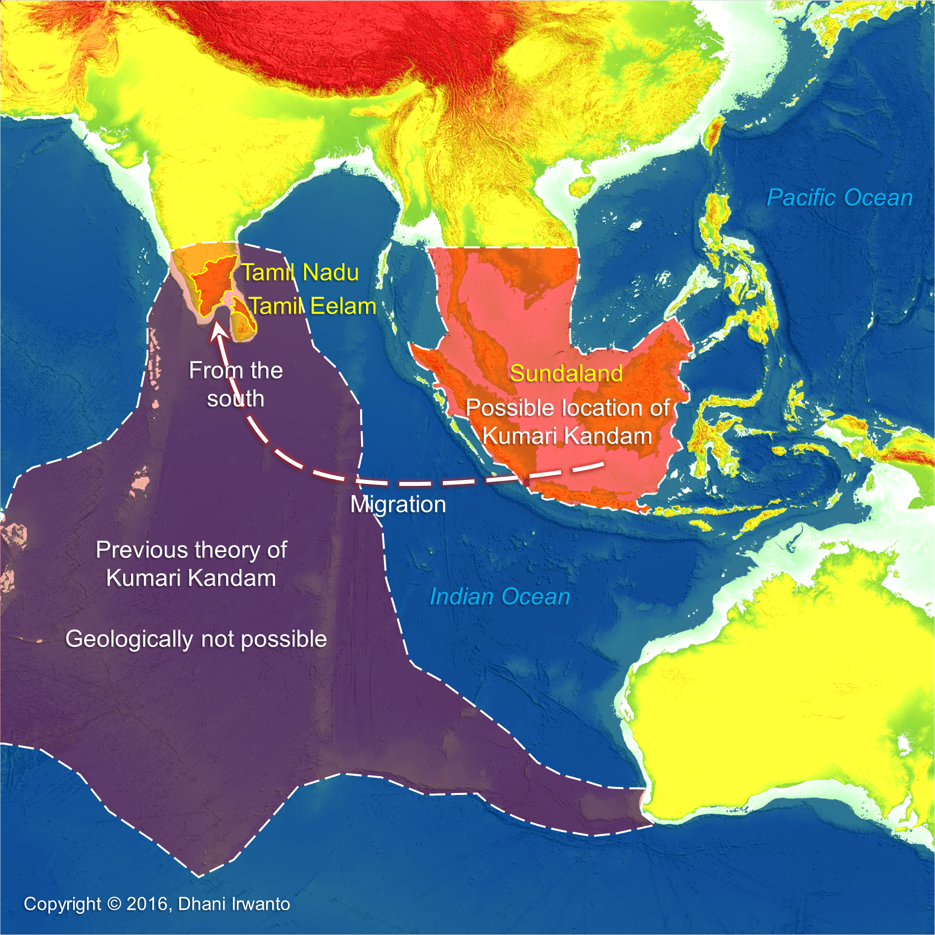
Kumari Kandam is a Tamil legend about ancient civilization geographically located in the Indian Ocean and then sank into the ocean. Though many Tamil writers do not assign any date to the submergence of Kumari Kandam, resorting to phrases like “once upon a time” or “several thousands of years ago”, but the stories are consistent with the theory of post-glacial been widely acceptable by scientists. This ancient Tamil civilization was located south to Tamil now, or to go to their new land they reached from the south. Vast land which sank in the geological past is not other than Sundaland. Previous theories hypothesized that the vast mainland of Kumari Kandam was located in the south of the Indian subcontinent, but the theory of tectonic plate movement does not support the existence of such land within some thousands years back. It can be presumed that Kumari Kandam is having a relationship with Atlantis or other civilizations thereafter.
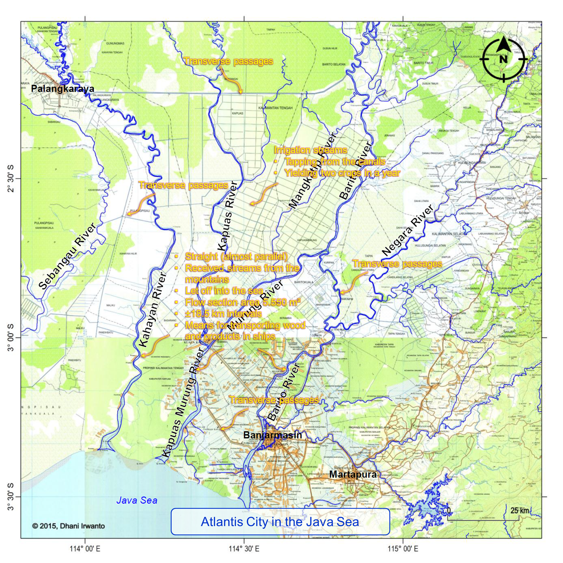
The years of the three stages of sangams are summed up to a date between 11,000 and 12,000 years BP, almost the similar number by the Plato’s dating on Atlantis of 11,600 BP, which could relate the Pandyan Kingdom to Atlantis. The mentions of mountain ranges which had forty-eight high peaks, the four rivers originated from the mountains, and the mining of gold and precious stones coincidentally match the Biblical Garden of Eden hypothesized by the author in the southern Kalimantan. The mountain Meru Malai, where there were mountain ranges which had forty-eight high peaks coincidentally match the Malea Mountains in the Ptolemy’s account of Taprobana, in which the author hypothesizes as the Malawi region in Kalimantan on the Schwaner-Muller mountain ranges. These mountain ranges have tens of peaks, to the south lays an expanse of alluvial plain and the origins of four main rivers: Kahayan, Kapuas, Barito and Negara. The Pahruli river excavated for irrigation purposes also coincidentally match the Plato’s description of Atlantis.
In Timaeus Section 24e Plato describes that the country of Atlantis was larger than Libya and Asia Minor put together, and was the way to other islands, and from these you might pass to the whole of the opposite continent which encompasses the true ocean.
Plato describes the Atlantis Plain plain was level, surrounded by mountains which descended towards the sea, smooth and even, rectangular and oblong shaped, three thousand stadia (about 555 kilometers) long, two thousand stadia (about 370 kilometers) wide, looked towards the south, sheltered from the north, surrounded by mountains celebrated for their number, size and beauty; and had wealthy villages of country folk, rivers, lakes, and meadows.
There were four kinds of channels: the circular (perimeter) ditch, the inland channels, the transverse passages and the irrigation streams. The perimeter ditch was artificial, 100 feet (about 30 meters) deep, 1 stadium (about 185 meters) wide, 10,000 stadia (about 1,850 kilometers) long, carried round the whole plain, received streams from the mountains, winding around the plain, meeting at the city and let off into the sea. The inland canals were straight, 100 feet (about 30 meters) wide, 100 stadia (about 18.5 kilometers) intervals, let off into the perimeter ditch and as means for transporting wood and products in ships. The transverse passages were cut from one inland canal into another. The irrigation streams tapping from the canals were meant to irrigate the land in the summer (dry season) while in the winter (rainy season) had the benefit of the rains.
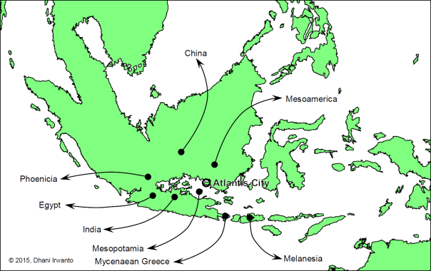
The author conjectures the origins of post-deluge civilizations of Atlantis as shown on the figure below. What did they bring?
Conjecture of origins of post-deluge civilizations
1. Civilization – As written by many authors, humanity was first flourished in Sundaland where ideal climatic conditions for development were found, and it was there that they invented farming, agriculture, trading and civilization.
2. Language – Scholastic belief by etymologists and linguists are positive that all world languages sprang from a common source. Paleo-Sanskrit is one of the theories that it is the ancestor of Sanskrit, Indo-Iranian, Indo-European, Mesoamerican, Sino-Tibetan, Austronesian and all other languages of the world.
3. Myths and doctrines – All the gods and goddesses of various world religions are parallel. Similar myths of great floods, creation and heaven are found all over the world. Brahma, Abram, Avram, Abraham and Ibrahim are believed by some as the same person.
4. Pyramid building – There are hundreds of pyramids still standing all over the world. Cultures separated by oceans, who supposedly never discovered each other’s existence, built these giant triangular structures, aligned them to cardinal directions, encoded within them sacred geometry/math, and used them as sepultures. The Gunung Padang pyramid in West Java, Indonesia dated 23,000 BC or earlier is claimed to be the earliest one.
5. Boat and ship building – Boat and ship have been the instrumental in the development of civilization, affording humanity greater mobility than travel over land, whether for trade, transport or warfare, and the capacity for fishing. Similarities among boat and ship building technology in the Austronesian and other parts of the world were observed. The earliest seaworthy boats may have been developed as early as 40,000 years ago, according to one hypothesis explaining the habitation of Melanesia and Australia.
In Genesis 2:10-14: “And a river ‘going out’ of Eden to water the garden; and from there was parted, and became into four ‘heads’. The name of the first is Phison: that it winds through the whole land of Havilah, where there is gold; and the gold of that land is good: there is ‘bedolach’ and the ‘gemstone’. And the name of the second river is Gihon: the same that it winds the whole land of Kush. And the name of the third river is Hiddekel: that it goes in front of Asshur. And the fourth river is Perat.”
The quest for pinpointing the exact location of the Biblical Garden of Eden and the four rivers is lasting more than two millennia, almost rivals the quest for the location of Atlantis, both in theory and in practice. Those searches for Eden had proven difficult due to uncertainty in identifying the rivers. Nobody had been able to look at modern maps of the regions mentioned in Genesis and figure out exactly where the Garden of Eden was.
At the head of the Persian Gulf by the present topography, only one river of the four, the Euphrates (Perat), is known by the same name in modern times. It presently originates in the mountains of Turkey and terminates when it merges with the Tigris River near the Iraq/Kuwait border region. Many have speculated that the Tigris is the river Hiddekel. This has led to speculation that the Garden of Eden was located somewhere in Turkey. This is assumed because the present headwaters of the Euphrates River originate in Turkey, as do the headwaters of the Tigris. Others have proposed that the other end of the Euphrates River, where it meets the Tigris, may be the true location. This requires interpreting the Tigris river as one of the other three (ie the Hiddekel), then interpreting a tributary confluence of rivers as a river head, and then locating at least two more rivers (or old river beds) as the other missing two. Having done so, they then claim that the Garden of Eden was near present day Kuwait. This is a convenient solution, but not one supported by the literal wording of the Bible or the geological and geographical realities of what river “head” means, ie headwaters or source of origin.
Several clues indicate that the Pishon and Gihon were located in Egypt or Arabia. The name Havilah, where the Pishon river is said to flow, means “sandy land” (Sarna, 1991). To an ancient Israelite audience, the explicit reference to an abundance of gold and precious stones evokes images of the Egyptian royalty from which they were birthed. This association also fits with the reference to “Kush”, identified later in Genesis as one ancestor of the Egyptians, hence it is believed the Gihon to be the famous Nile River. However, if these were indeed the Pison and Gihon rivers, two of four that flowed out of the Garden of Eden, they do not correspond with the present-day headwater source of the Euphrates or Tigris up in Turkey. The respective watersheds of the Tigris/Euphrates and Nile rivers are separated by hundreds of miles, and these rivers are fed by completely different mountain ranges.
So, where was the Biblical Garden of Eden located?
It was in Southeast Asia that man, after emigrating from the semi-deserted savannas of Africa, first found the ideal climatic conditions for development, and it was there that he invented agriculture and civilization. All this took place during the Pleistocene, the last of the geological eras, which ended a scant 11,600 years ago. With the end of the Pleistocene Ice Age, the immense glaciers that covered the whole of the northern half of North America and Eurasia melted away. Their waters drained to the sea, whose level rose by the estimated amount of about 100 – 150 meters (dos Santos, 2005).
As the Ice Age ended, there was sea water rise drowned forever the huge continental shelf of Southeast Asia, namely the Sundaland, and caused a population dispersal which fertilized the Neolithic cultures of China, India, Mesopotamia, Egypt and the eastern Mediterranean, thus creating the first civilizations. There were three catastrophic and rapid rises in sea level. The last of these, which finished shortly before the start of civilization in Mesopotamia, may have been the one that was remembered. The Southeast Asian contributions to the building of the first cities in Mesopotamia may not have been solely technological. While they may have brought the new ideas and skills of megalithic construction cereal domestication, sea-faring, astronomy, navigation, trade and commerce, they may also have introduced the tools to harness and control the labor of the farmers and artisans. These included magic, religion, and concepts of state, kingship and social hierarchy. Uniquely shared folklore shows that counterparts and originals for nearly every Middle Eastern and European mythological archetype, including the Flood, can be found in the islands of Indonesia and the southwest Pacific. Southeast Asia is revealed as the original Garden of Eden and the Flood as the force which drove people from Paradise (Oppenheimer, 1997).
In Genesis 2:8: “The Lord God planted a garden in the east, in Eden, and there He placed the man whom He had formed.” and in Genesis 11:2: “And it came to pass, as they journeyed from the east, that they found a plain in the land of Shinar; and they dwelt there.”
The land of Shinar is identified as Mesopotamia. The name may be a corruption of Hebrew Shene neharot (“two rivers”), Hebrew Shene arim (“two cities”), or Akkadian Shumeru. The people of Mesopotamia were a dispersal from Southeast Asia (“the east”) caused by catastrophic and rapid rises of sea level in Sundaland (“they journeyed from the east”). Their land of origins, Eden, was therefore in Sundaland (“a garden in the east, in Eden”).
In Genesis 2:9: “Out of the ground the Lord God made to grow every tree that is pleasant to the sight and good for food. The tree of life was also in the midst of the garden, along with the tree of knowledge of good and evil.”
In Genesis 2:19-20: “Out of the ground the Lord God formed every beast of the field and every bird of the sky, and brought them to the man to see what he would call them. Whatever the man called every living creature, that was its name. The man gave names to all the livestock, to the birds of the sky, and to every beast of the field, but for Adam there was not found a helper suitable for him.”
The Lord God created the Garden of Eden specifically for Adam, the first man, whom Lord God had formed. Thus, the Garden of Eden was perfect. It offered both beauty and sustenance, being home to every tree “that is pleasant to the sight and good for food” and a source of freshwater from the river to drink.
The Garden of Eden could not be found because everyone had been looking in the wrong place. In a hypothesis, the author identifies a location of the Garden of Eden as a vast plain surrounded by mountain ranges in southern part of Kalimantan Island, as shown on the figure below.
The Indonesian territory of Kalimantan makes up 2/3 of Kalimantan Island. Well known for its tropical forests, rich natural resources; and exotic, endemic and diverse flora and fauna, Kalimantan offers a unique, unexplored world of its own. This territory has a number of nature reserves to protect its unique flora and fauna. Kersikluway is where the very rare Black Orchid (Colongenia Pandurata) grows, located upstreams the Mahakam River, East Kalimantan. Bontang, in the regency of Kutai, has rare flora and fauna. The Kutai National Park near Bontang is worth visiting to see scenery especially those at Berasbasah. Tanjungputing National Park in Central Kalimantan is the oldest conservation site of Kalimantan’s flora and fauna. The park is inhabited by Orangutans, Owa-owa, Bekantan and other primates. Also found here the Orangutan Rehabilitation Center which is supported by the World Wildlife Fund (WWF). In West Kalimantan, Gunungpalung National Park located in the Ketapang regency is home to miscellaneous flora and fauna. The Rayapasi mountain located in the Singkawang regency is also an interesting place to visit to see the Rafflesia or giant flower. Singkawang is also a nature reserve. The forest of Sanggau is worth a visit where hot springs, lakes and caves can be found. The other nature reserves are the forests of Baning and Kelam Hill in the Sintang regency. While in Kapuashulu, there is the Bentuang forest. In South Kalimantan, there is the Kaget island, home to a wide variety of birds and monkeys, most notably the humorous longnosed proboscis monkeys.
The region hypothesized as the Garden of Eden is populated by the Dayaks, the indigenous inhabitants of Kalimantan. The center of the region is covered with tropical forest, which produces rattan, resin and valuable timber such as Ulin and Meranti. The southern lowlands are dominated by peatland swamps that intersect with many rivers.
The region’s climate is wet weather equatorial zone with an eight-month rainy season, and 4 months of dry season. Rainfall or precipitation is 2,800 – 3,400 mm per year with an average of 145 rainy days annually.
The Muller-Schwaner Mountains stretch from the north-east of the region to the south-west, 80% of which is covered in dense forest, peatland swamps, mangroves, rivers, and traditional agriculture land. Highland areas in the north-east are remote and not easily accessible. Non-volcanic mounts are scattered in this area including Kengkabang, Samiajang, Liangpahang and Ulugedang. The Meratus Mountains are situated approximately along the eastern part of the region. The mountains have mist-laced, river-crossed peaks, dense jungles, steep valleys and jagged karst formations. The mountains are inhabited by the “semi-nomadic” Meratus Dayak people, whose strong religious customs play to the soundtrack of the shaman’s drum.
The above descriptions indicate that the region deserves to be called as the Garden of Eden as in the Bible.
The Bible says that “a river ‘going out’ of Eden” and then does something that most rivers do not do; specifically, split into four separate ‘heads’ or rivers that flowed downstream, all fed from a common single river source. Almost all rivers start from a single source or are fed by multiple sources (tributaries). The verb in Hebrew is a present participle instead of the imperfect. Also, a noun phrase at the beginning of a verse is unusual. Again, the words “and from there” come before the verb “was parted” show that this verb has no subject expressed.
Those singularities are perceived because the verse is interpreted verbatim. The present participle form of the verb implies that the words are in a phrase, the “river going out of a region (‘Eden’)”, that can be interpreted as the “hydrographical region”, the “hydrological region” or the “river catchment region”. The next phrases again affirm this interpretation, “from there was parted, and became into four ‘heads’”, that can be interpreted as “which consisted of four main river sub-catchments (sub-regions)”. The interpreted phrases were seemingly not found in the original language of the verse. So, the verse can be interpreted as “The hydrological region of Eden consists of four main river sub-catchments.”
The naming of the Biblical rivers was allegedly derived from the geographical alignment of the rivers. The numbering of the rivers was also in accordance with the order, from west to east. The simple present form of the verbs denotes that the conditions are not changed overtime. The four rivers are identified as Kahayan for Pishon, Kapuas for Gihon, Barito for Hiddekel and Negara for Perat as in the above figure, as discussed below.
Phison
In Genesis 2:11-12: “The name of the first is Phison: that it winds through the whole land of Havilah, where there is gold; and the gold of that land is good: there is ‘bedolach’ and the ‘gemstone’.”
The Hebrew name for Phison is Pîšōn (פִּישׁוֹן) which means “increase” (noun) and could be derived from pûsh (פּוּשׁ) which means “to spring about”, “to be dispersed”, “to be scattered” or “to be spread”. When applied in the alignment of the river, this could mean that the river is “dispersed”, “refracted” or “deflected”. Looking at the geography of the region, the Kahayan River is deflected westward, as seen from downstream side.
At about the middle of Kahayan River, that part of the river is winding. The winding of a river signify that the topography where the river traverses is flat and tends to be used as a center of community. So that Havilah could be at this site. Havilah is described in lengthiest in Bible compared to the other places in the Eden, implies that this place is the most important or populated among the others. This place can be easily accessible from the southern coast through Kahayan River for the outsiders to visit. The present capital of Central Kalimantan Province, Palangkaraya, is situated in the area too.
The Bible says that there is gold in Kavilah and the gold is good. Kahayan River is renowned for its gold mining. A place named Gunungmas, meaning “the hill of gold”, in the middle of Kahayan River, is rich of gold and some other minerals such as silver, copper, iron, zinc, tin, platinum and zircon. Today, the gold reserves in the area are approximately 45 million tons. Besides some other classic names of the island, Kalimantan bore the name of Nusa Kencana meaning “the island of gold”, probably at Gunungmas as this site is easily accessible from the southern coast through Kahayan River. Gold and zircon are abundant in southern Kalimantan as these are the mainstay of the region at this time.
The Bible mentions “bedolach” as a product of Kavilah. Its Hebrew word is bedôlach (בּדלח), probably derived from bâdal (בּדל) meaning “to divide” (in various senses literally or figuratively, “separate”, “distinguish”, “differ”, “select”, etc) or a foreign word. “Bedolach” is among the Biblical words which the meanings are unclear. According to the Septuagint, is the carbuncle or crystal; according to others, the pearl, or a particular kind of gum. The last is the more probable, regarding the various Greek forms of the word bdella (Βδέλλα) and bdellion (Βδέλλιον), a semi-transparent oleo-gum resin.
Southern Kalimantan is renowned for its producer of natural gum sap locally known as “jelutung” (Malaysian “jelutong”) tapped from the same name of trees (Dyera spp) and is the largest exporter of the commodity in the world. Its natural distribution is scattered locales in low-elevation tropical evergreen forest. The kind of tree which grows in the swamp (Dyera pollyphylla) is an important source of chewing gum. Besides, “jelutung” sap is an industrial material for adhesives, varnishes, racing tires, waterproofing and insulating materials.
This region is also famous for a gutta-percha tree locally known as “nyatoh” or “nyatu” (Palaquium spp). Its habitat is coastal, lowland mixed dipterocarp, swamp and montane forests. Dayak communities in the region utilizing “nyatu” sap as a raw material for making handicrafts, from an epithet that can only be found in the region.
The Bible mentions “gemstone”, also as a product of Kavilah. Its Hebrew word in the Bible is shôham (שׁהם) from an unused root probably meaning “to blanch”; “a gem” or “a precious stone”.
The story of Kalimantan’s rich gemstone resources has reached worldwide fame. Kalimantan, as they are known in the past and the West, is indeed the sources of many natural gemstones and have been documented well in many literatures. Amethyst or locally named “kecubung”, a violet jewel, is specifically found and renowned in southern Kalimantan. A place named Martapura located in the region is famous from the early past for its jewelry industry. Zircon – a gemstone with natural colors varies between colorless, yellow-golden, red, brown, blue, and green – is abundantly found along the alluvial deposits of inland rivers in southern and western Kalimantan, as a byproduct of gold mining activities.
Gihon
In Genesis 2:13: “The name of the second river is Gihon; the same that it winds the whole land of Kush.”
The Hebrew name for Gihon is gı̂ychôn or gichôn (גּחון גּיחון) which means “bursting forth”, could be derived from primitive root of gı̂yach or gôach (גּח גּיח) which means “to gush forth (as water)”, “to burst forth”, “to draw forth”, “to bring forth” or “to break forth”. When applied in the alignment of the river, this could mean that the river is multiply “broken forth”, “come apart”, “divided” or “branched”. Looking at the geography of the region, the Kapuas River is evenly branched into three tributaries that look like a burst.
At the confluence of the tributaries and at a distance downstream, that part of the river is winding. Kush could be at this site and could become the second important place after Kavilah.
Hiddekel
In Genesis 2:14: “The name of the third river is Hiddekel; it goes in front of Asshur.”
The Hebrew name for Hiddekel is chiddeqel (חדּקל) which means “rapid” or “darting”, probably derived from chaddékel (דֶּקֶל חַד) meaning “a sharp and swift arrow” (Keil and Delitzsch), or of foreign origin. When applied in the alignment of the river, this could mean “a swift arrow trajectory”, “a long and direct trajectory” or simply “long and direct”. Looking at the geography of the region, the Barito River is long, direct and almost straightly aligned. The verb “goes” is applied instead of “winds” as in the other two rivers, implies that the river is in direct or straight alignment.
The Bible says that Hiddekel goes in front of Asshur. The Hebrew word qidmâh (קדמה) can mean “in front of”, “over against” or “on the east of”. So, instead of “goes in front of Asshur” the phrase can be interpreted as “goes on the east of Asshur”.
Perat
In Genesis 2:14: “The fourth river is the Perat.”
The Hebrew name for Perat is perâth (פּרת) which means “to break forth”. When applied in the alignment of the river, this could mean “to diverge” or “to branch”. Looking at the geography of the region, Negara River is a branch or tributary of the Barito River.
The Bible decreases the description of this river, without explanation of the alignment or a nearby place name, and puts it in the last order. This could mean that Perat is the least important river compared to the other three in the region.
Perat is generally associated with the Euphrates, the Greek manner of pronouncing the Hebrew perâth, the first syllable being simply a help in sounding the double consonant. Also, Perat finds its equivalent in the Assyrian Purattu and the Old Persian Ufratu. Names similar to these may be found in various places. They cannot prove much more than resemblance in language, and that may be sometimes very remote. Several like names occur in profane history. Geography affords numerous examples of the transference of names from one place to another along the line of migration. We may therefore expect names to travel with the tribes that bear them or love them, until they come to their final settlements.
The Genesis flood narrative makes up chapters 6–9. The narrative indicates that God intended to return the Earth to its pre-Creation state of watery chaos by flooding the Earth because of humanity’s misdeeds and then remake it using the microcosm of Noah’s ark. Noah in Hebrew is nôakh (נוח), from the root n-w-ḥ (נ־ו־ח) or n-ḥ (נ־ח); and pronounced Aramaic nuħ.
It is highly probable that Noah and Manu, the name of the flood hero in the traditions of India, were the same individual. Manu, like Noah, is said to have built an ark in which eight people were saved. Manu and Noah were both the father of all post-flood mankind. The Noah Flood story in Genesis matches the Gilgamesh flood myth so closely that “few doubt that it derives from a Mesopotamian account”.
The word Manu is related to the Germanic Mannus, the founder of the West Germanic peoples, mentioned by the Roman historian Tacitus in his book Germania. Mannus is also the name of the Lithuanian Noah. The same name may even be reflected in the Egyptian Menes (founder of the first dynasty of Egypt) and Minos (founder and first king of Crete). Minos was also said in Greek mythology to be the son of Zeus and ruler of the sea. Anu appears in Sumerian as the god of the firmament, and the rainbow was called “the great bow of Anu”, which seems a clear reference to Noah. In Egyptian mythology Nu was the god of waters who sent an inundation to destroy mankind. In southern Kalimantan folklore, Maharaja Bunu is the first man who inhabited the region.
The Sanskrit form manusa, Indonesian manusia, Swedish manniska, Gothic manna and English man are closely related, meaning “human being”. The aboriginals of Japan are called Ainu, a word which also means “man”.
In the Sioux language, it took the form minne, meaning “water”. In the Assiniboine language, minnetoba meant “water prairie”. However, this word may also have been derived from the Cree and Ojibiva-Saulteaux languages, which meant “the place of the Great Spirit”. Manitou (“the Great Spirit”) was the chief god among Algonquins. The name of Managua, the capital of Nicaragua, comes from the Nahuatl managuac, which means “surrounded by ponds”. The ancient Javanese banu and the Dayak Barito banyu mean “water”. There is Ino, a sea-goddess in Greek mythology, and the Greek word naiade, meaning “river nymph”. Further, Baruna or Waruna in the Indonesian archipelago which given the title of the Water God, is the ruler of the seas and oceans – in later time considered as a manifestation of Brahman in dharmic mythology.
The original Sanskrit word for “ship” is nau. This root has developed even in English into such words as “navy”, “nautical”, “nausea”, etc. In Norse mythology, Njord was the god of ships, living at Noatun, the harbor of ships. In this language, the syllable “noa” is related to the Icelandic nor, meaning “ship”.
Thus, Noah and the waters of the great Flood are not only recalled in the ancient traditions of all nations, but their names have also become incorporated in many and varied ways into the very languages of his descendants. The trails are tenuous and often almost obliterated, so that some of the inferred connections are speculative and possibly mistaken, but the correlations are too numerous to be only coincidental, thus adding yet one more evidence for the historicity of the worldwide flood.
The local folklore of southern Kalimantan tells a story resembles the Noah. In Panaturan, the sacred folklore of Ngaju Dayak inhabiting southern Kalimantan region, the first human who descended to this world is named Maharaja Bunu. At first he lived in a divine world at Lewu Nindan Tarung with his triplets namely Maharaja Sangiang and Maharaja Sangen. The triplets are the children of Manyamei Tunggul Garing Janjahunan Laut and his wife Kameloh Putak Bulau Janjulen Karangan, the first humans that were created by Ranying Mahatala Langit, the supreme God. Maharaja Bunu was descended to Pantai Danum Kalunen (this world) using a ship namely Palangka Bulau Lambayung Nyahu or simply Palangka, on Samatuan Hill, from where his descendants were spread out to fill the earth. According to Panaturan, the hill is located between Kahayan Rotot and Kahayan Katining. The Palangka was loaded with supplies necessaries for life, such as farming and hunting tools, weapon making tools, rice seeds, fruit and plants seedlings, as well as livestock breeds. Palangkaraya, meaning the Great Palangka, is now the capital of Central Kalimantan Province.
A vast plain dominates the topography of the southern Kalimantan region which is level, smooth and even. The slope of the ground surface is mostly less than 1% declining southward towards the Java Sea and almost no visible mound on the whole plain. The area of the plain is located in a tropical rain forest region, has high precipitation rate over the year, has warm temperature over the year, mostly swampy and has many large rivers and tributaries so that the region is fertile and rich of food and daily necessity resources.
Rivers are flowing on the plain; Barito, Kapuas, Murung, Kahayan and Sebangau Rivers are among them. The regimes of these rivers should have been changed over the past thousands of years due to processes of flooding, sedimentation, river bed movement and meandering on a very flat plain. Interchanges of flows and orders among the rivers might also occur. Numerous transverse passages connecting one river to the other exist in the region, some of them were built or rehabilited in recent times. The passage is known locally as “anjir”, a canal linking two rivers as part of the transportation network. The canals are also used as primary tidal swamp irrigation canals supplying water to and draining from the cultivated lands.
The plain is elevated from 0 to about 40 meters above the average sea water level. Being in a flat and low plain, the tidal affect of the sea may reach as far as 160 kilometers away from the coast.
In Genesis 7:12: “The rain fell upon the earth for forty days and forty nights.”
In Genesis 7:12-20: “The flood was on the earth forty days, and the water increased and lifted up the ark, so that it rose up above the earth. The water prevailed and increased greatly upon the earth, and the ark floated on the surface of the water. The water prevailed exceedingly on the earth, and all the high mountains that were under the whole heaven were covered. The waters prevailed upward and the hills were covered fifteen cubits deep.” 15 cubits is approximately 23 feet or 6.8 meters.
Kalimantan Island is among the regions on the Earth having the highest yearlong rainfall. The probabilistic study of rainfall in the region of southern Kalimantan showed that it may reach as high as 500 millimeters per day for a 100-year return period and even higher on the mountainous regions. Its rainfall catchment region is a bulb-like shape where the mountainous upstream area is wider – with highest rainfall – and the downstream, on the plain, is narrower. Therefore, flood catastrophe risk on this plain is extremely high, aggravated by its catchment shape, rainfall distribution, rainfall intensity; level, even, smooth and low plain; and farther reach of sea tides. Everyone can imagine how worst was the extraordinary Biblical Flood from a 40-day and 40-night rainfall on this region. The Noah Flood could have happened here.
Due to the high level of flood risk in the region, it was possible that the floods had several times repeated for the recent thousands of years. Civilization that grew back after the flood will be swept back in the next flood, returned to its original nature and humanity who survived spread to other parts of the world.
Garden of Eden and Atlantis are among the memories by the Mesopotamian and Egyptian about the land of origin of the first civilization, before population dispersal caused by catastrophic and rapid rises in sea level in the Pleistocene Ice Age. Mesopotamia and Egypt are among the oldest civilizations after the Ice Age which had writing traditions. Other civilizations continue their memories with myths and legends that collectively share the same stories across distances and time.
Bill Hanson (2006) has written a work that links the Garden of Eden with Atlantis. He identifies five similarities between the two accounts:
• Both prehistoric locations are regarded as “lost paradises”
• The four rivers of Eden are reflected in the four waterways of Poseidon the island capital of Atlantis.
• Atlantis started with ten kings and the Bible speaks of ten patriarchs.
• Zeus destroyed Atlantis because mortals and gods mated, whereas the Bible records the mating of the “sons of God” and human females.
• Atlantis was flooded just as the Age of the Patriarchs ended with the flood of Noah.
From Plato’s Timaeus Sections 25c and 25d: “But afterwards there occurred violent earthquakes and floods; and in a single day and night of misfortune all your warlike men in a body sank into the earth, and the island of Atlantis in like manner disappeared in the depths of the sea.”
From Plato’s Critias Section 108e: “and when afterwards sunk by an earthquake, became an impassable barrier of mud to voyagers sailing from hence to any part of the ocean.”
In Timaeus, Plato mentioned that the island of Atlantis was beset by an earthquake and a flood, and sank into a muddy sea. Plato did not recognize “tsunami” so he equated it to “flood”. The Greek historian Thucydides suggested in his late-5th century BC History of the Peloponnesian War, that tsunamis were related to submarine earthquakes, but the understanding of a tsunami’s nature remained slim until the 20th century and much remains unknown.
A tsunami, also known as a seismic sea wave, is a series of water waves caused by the displacement of a large volume of a body of water, generally an ocean or a large lake. Earthquakes, volcanic eruptions and other underwater explosions, landslides, glacier calvings, meteorite impacts and other disturbances above or below water all have the potential to generate a tsunami. Tsunami waves do not resemble normal sea waves, because their wavelength is far longer. Rather than appearing as breaking waves, tsunamis may instead initially resemble rapidly rising tides, and for this reason they are often referred to as tidal waves.
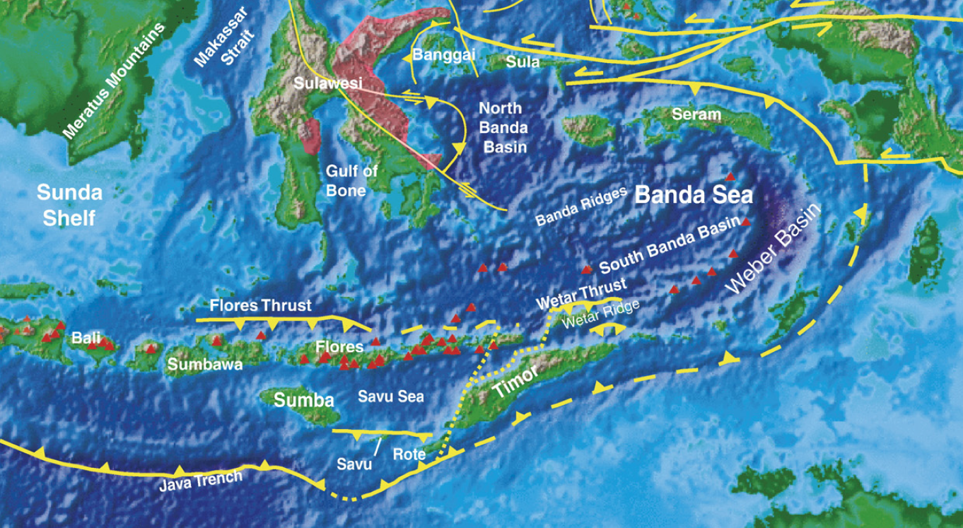
Banda Arc
The Banda Arc, a west facing horse-shoe shaped arc in eastern Indonesia situated west of Papua and in the easternmost extension of the Sunda subduction zone system, defines the locus of three converging and colliding major plates, the Indo-Australian Plate, the Pacific Plate and the Eurasian Plate, and reveals a characteristic bowl-shaped geometry in seismic tomographic images. Splinters of the Mesozoic southern Tethyan crust now form the base of the Banda Sea. On the surrounding islands, dismembered ophiolites can be found in high mountains. Recent studies in the metamorphic aureoles at the base of these ophiolites have revealed a new alternative for the explanation of the complex tectonic development of the arc, ie by invoking obduction as being the major mechanism in the emplacement of southern Tethyan crust onto the passive Australian continental margin.
The Banda Sea encircled by the Banda Arc occupies the main portion of the Banda Sea Plate. Frequent and significant earthquakes, tsunamis and volcano eruptions took place in one of the most complex tectonic regions on Earth, in the general framework of the triple collision of continental Australia plate, oceanic Pacific plates and the southernmost tip of the Eurasian plate, called ‘Sundaland’. The region is composed of a large number of geological provinces. In particular, the eastern termination of the Banda Sea features a number of strongly curved, concentric tectonic provinces.
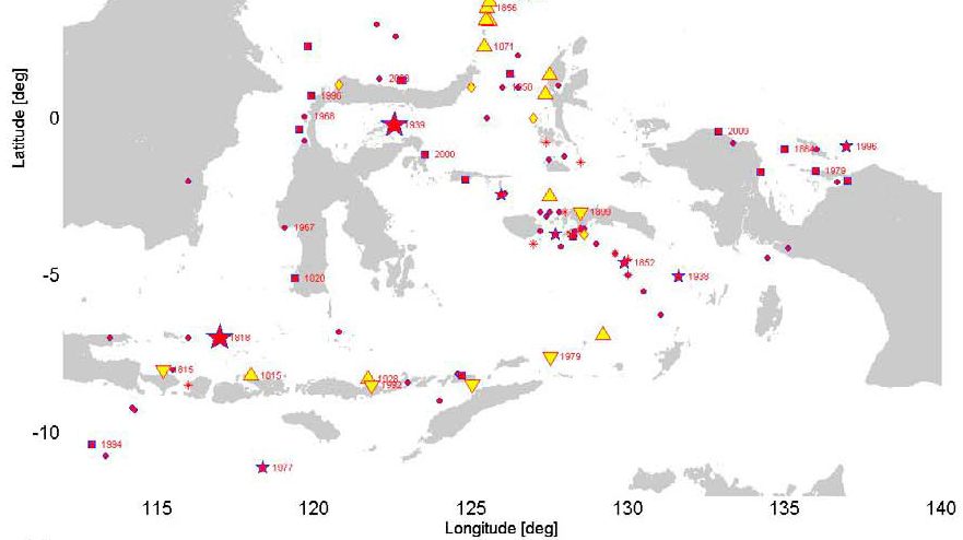
The USGS records of the largest earthquakes in the world since 1900 show that the earthquake in Banda Sea on February 1, 1938 with a magnitude of 8.5 is among them. Another at least 10 occurrences of large earthquakes in this region between 17th and 20th centuries are also known (Wichmann, 1918, 1923; Harris and Major, 2012). The NOAA records of the world’s deadliest tsunamis from 1650 BC to 2010 AD cited from the National Geophysical Data Center show that 3 occurrences of deadliest tsunamis in the region are among them: in 1674, 1899 and 1992. Unfortunately, no investigation of deposits of ancient tsunamis is carried out in the region. Mount Tambora eruption in 1815 was the largest volcanic eruption in recorded history, caused global climate anomalies that included the phenomenon known as “volcanic winter”: 1816 became known as the “year without a summer” because of the effect on North American and European weather. Crops failed and livestock died in much of the Northern Hemisphere, resulting in the worst famine of the 19th century.
Locations for recorded historical tsunamis. Year of occurrence is indicated for some events. Yellow markers indicate non-seismic or unknown sources, red markers indicate seismic sources. Large stars display magnitudes M ≥ 8.5, small stars 8.5 > M ≥ 8.0, squares 8.0 > M ≥ 7.5, circles M < 7.5, an asterisk means that no magnitude is reported. Upward-pointing triangles indicate volcanoes or combinations of volcanoes and other sources, and downward-pointing triangles indicate landslides or combined landslides/earthquakes. Diamonds indicate unknown sources.
Dynamics of Tsunami
Tsunamis, like the ordinary wind waves, can undergo shoaling, refraction, reflection and diffraction. Most tsunami generated by large earthquakes travel in wave trains containing several large waves. In some cases, the waves in a tsunami wave train consist of an initial peak that then tapers off in height exponentially over 4 to 6 times. In other cases, the tsunami wave train consists of a maximum wave peak well back in the wave sequence.
The time it takes for a pair of wave crests to pass by a point is termed the wave period. This is a crucial parameter in defining the nature of any wave. Tsunamis typically have periods of 100 – 2,000 seconds (1.6 – 33 minutes), referred to as the tsunami window. Waves with this period travel at speeds of 600 – 900 km/hr (166 – 250 m/s) in the deepest part of the ocean, 100 – 300 km/hr (28 – 83 m/s) across the continental shelf, and 36 km/hr (10 m/s) at shore (Iida and Iwasaki, 1983). Because of the finite depth of the ocean and the mechanics of wave generation by earthquakes, a tsunami’s wavelength – the distance between successive wave crests – lies between 10 and 500 kilometers. These long wavelengths make tsunami profoundly different from swell or storm waves.
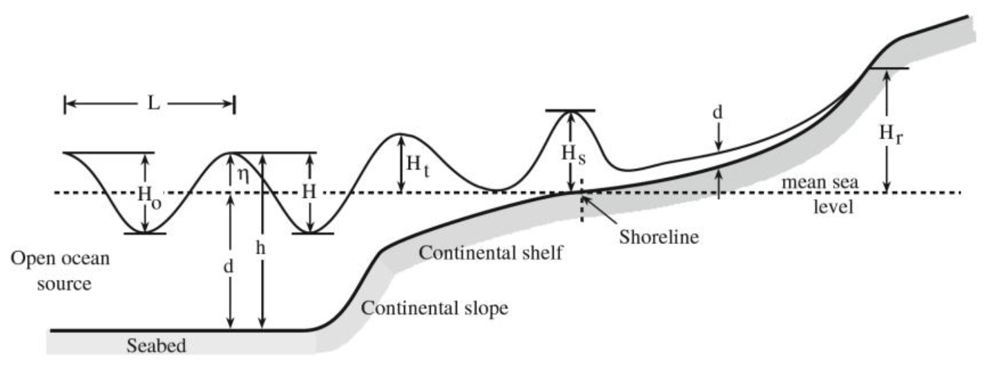
The simplest form of ocean waves is sinusoidal in shape and oscillatory. Oscillatory waves are described for convenience by three parameters: their height (H), their wavelength (L), and their water depth (d). In deep water, the most significant factor is the ratio H/L, or wave steepness. In shallow water it is the ratio H/d, or relative height. For local tsunamis propagation in water depths greater than 50 meters, these ratios are much less than one. This implies that wave height relative to wavelength is very low – a feature characterizing tsunami in the open ocean.
Shallow water begins when the depth of water (d) is less than half the wavelength (L). As oceans are rarely more than 5 kilometers deep, the majority of tsunamis travel as shallow-water waves. In this case, the velocity of the wave is C = (gd)0.5 and the wave length is L = CT; where g = gravitational acceleration (~9.8 m/s2) and T = wave period. The latter equation holds for linear, sinusoidal waves and is not appropriate for calculating the wavelength of a tsunami as it moves into shallow water. Linear theory can be used as a first approximation to calculate changes in tsunami wave height as the wave moves across an ocean and undergoes wave shoaling and refraction. The following formulae apply: Hi = KrKsHo, Kr = (bo/bi)0.5 and Ks = (do/di)0.25; where Kr = refraction coefficient, Ks = shoaling coefficient, b = distance between wave orthogonals and d = water depth. Subscripts o and i denote at a source point and at any shoreward point, respectively. For a tsunami wave traveling from a distant source, the wave path or ray must also be corrected for geometrical spreading.
Tsunami are known for their dramatic run-up heights, which commonly are greater than the height of the tsunami approaching shore by a factor of 2 or more times. Tsunamis, having long periods of 100 – 2,000 seconds, can also be excited or amplified in height within harbors and bays if their period approximates some harmonic of the natural frequency of the basin – termed resonance. Here tsunami can oscillate back and forth for 24 hours or more. The oscillations are termed seiches. Seiches are independent of the forcing mechanism and are related simply to the 3-dimensional form of the bay. For a closed basin, Ts = 2Lb(gd)-0.5 and for an open basin, Ts = 4Lb(gd)-0.5; where Lb = length of a basin and Ts = wave period of seiching in a bay.
Say, there was an earthquake in the Flores Sea or Makassar Strait in Atlantis era causing an initial wave of 10 meter high. The sea depth was about 1,000 meters. The wave velocity was then C = (9.8 × 1,000)0.5 ≈ 100 m/s (360 km/hr). With an average Java Sea depth of 10 meters (in the era of Atlantis), assuming Kr = (1/4)0.5 ≈ 0.5 and Ks = (1,000/10)0.25 ≈ 3.2, by a simple calculation, the wave height was Hi = 0.5 × 3.2 × 10 ≈ 16 meters in the ancient Java Sea. Approaching the shoreline with a depth of 2 meters (assuming Kr = 1 and Ks = (10/2)0.25 ≈ 1.5), the wave height was Hi = 1 × 1.5 × 16 ≈ 24 meters and the run-up could be twice. It was really a destructive wave and penetrated inland on a very flat plain. In fact, the recorded run-up of 1674 AD Banda Sea tsunami was much larger, 80 – 100 meters high on Ambon Island. Thus, we could speculate that the destruction of Atlantis was among others caused by a tsunami. It was due to the tsunami waves traveling in shallow water (ancient Java Sea) and penetrated inland on a very flat plain. The Meltwater Pulse 1A was probably also contributed the occurrence of earthquakes and tsunamis due to speedy increase of water burden on the Banda Sea Plate.
In Atlantis era, the Java Sea was forming a gulf with a rather narrow entrance and due to the many islands in it resonances and seiches might also occur, causing the wave became much higher and prolonged, and then aggravated its destructive nature.
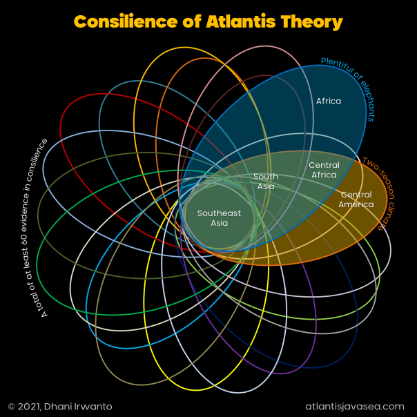
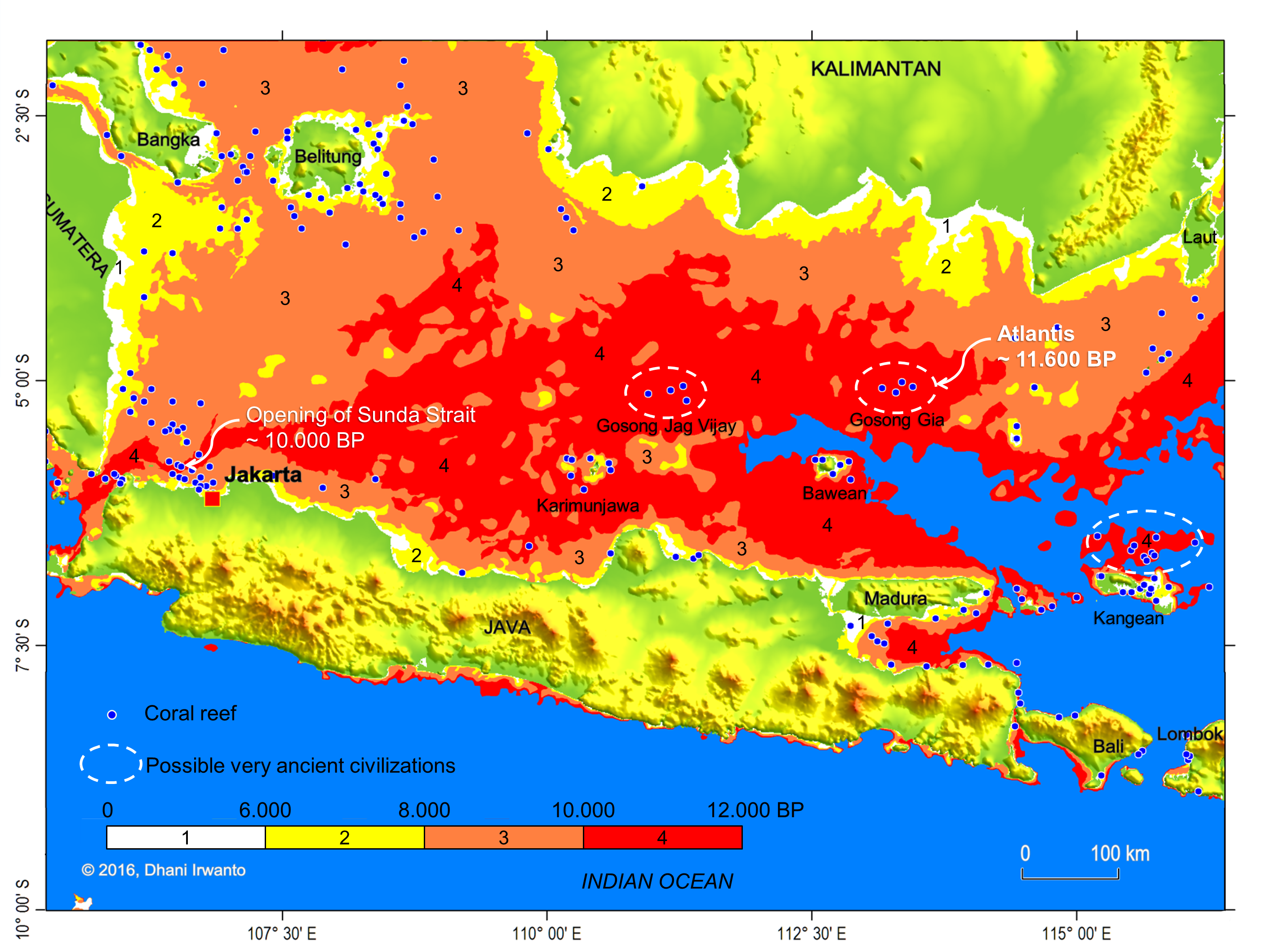
The following list shows a summary of the converging evidence of the existence of Atlantis in Sundaland made by the author. Some other less important evidence are not included. The quoted terms, wherever possible, are the English translation of the terms taken from the Plato’s account, either in Greek or terms not found in Greek. Phrases in parenthesis are interpretations by the author.
There are at least 60 evidence in consilience. Consilience or convergence of evidence or concordance of evidence in science and history is the principle that evidence from independent, unrelated sources can “converge” on strong conclusions. That is, when multiple sources of evidence are in agreement, the conclusion can be very strong even when none of the individual sources of evidence is significantly so on its own.
These evidence are the “potsherds” in the verification of a theory using a Potsherd Model, where, the more “sherds” collected, reassembling them can give clearer representation of the “pot”. In this case, the reassembled “pot” from the “sherds” (evidence) is then compared to the descriptions by Plato (the “reference pot”) to prove the theory. It now appears from the list that the “pot” is almost fully reassembled and representative to the “reference pot”.
1. At a distant point in the “Atlantic Ocean” (ancient Greek understanding) (Timaeus: 24e)
What we call now by the name of “Atlantic Ocean” is not the same as that of the ancients. Herodotus, Aristotle, Plato, Strabo and several other ancient authors are very specific on the fact that the “Atlantic Ocean” was the whole of the coterminous “earth-encircling ocean”, which we now arbitrarily divide into Pacific, Indian and Atlantic oceans.
The phrase “at a distant point in the Atlantic Ocean” implies that Atlantis was far away in the ocean in what we know today the eastern Indian Ocean or the Pacific Ocean.
The state of Atlantis is located at a distant point in the Atlantic Ocean, by itself put the city of the Athens at a distant location as well since both regions were close together as told in the story.
The Atlantis and the “Athens” were bordered by Monuments of Heracles which among others were placed in a strait called the Strait of Heracles. The city of Atlantis was within the strait, meaning that the city of the “Athens” was outside of the strait and the sea. These geographic descriptions are not compatible to the existence of Atlantis around the Mediterranean Sea.
The statements that “the ‘Athens’ which formerly had a vast and fertile land, at the time of Solon had sunk all around and all that remains were small rocky parts, and only a few trees growing and consists almost entirely of bare land so that rain water flows only just on it and then lost to the sea”, do not describe the conditions of the city of Athen at the time of Solon.
The statement that “the city of the Athens’ had been established a thousand years before Egypt” is also incompatible.
4. Larger than “Libya” and “Asia” (Asia Minor) combined (ancient Greek understanding) (Timaeus: 24e – Critias: 108e)
5. The landscape of the whole country, at the region on the side of the ocean, was very lofty and precipitous. (Critias: 118a)
The sea level at the time of Atlantis, about 11,600 years ago, was approximately 60 meters below the present-day sea level.
The Plato’s expression that “Atlantis was the way to other islands, and from there might pass to the opposite continent which encompasses the true ocean” precisely points to Sundaland. Traveling further from there, one may reach some islands like Nusatenggara, Sulawesi, Maluku, Mindanao and Luzon, and may pass the opposite continent, ie the large “Sahul Continent” combining Australia, Papua and the land connecting them.
“The land of Atlantis is larger than Libya and Asia Minor” also precisely affirms its size. The expression that “the region on the side of the ocean was said to be very lofty and precipitous” further confirms the Sundaland location of Atlantis. The expression “inside a strait and in a sea encircled by a boundless continent” confirms its capital location.
It is said that Atlantis had “sun in the above”, “benefit of the annual rainfall”, “abundance of water”, “excellently attempered climate” and “summer and winter seasons”. These are strongly characterize a tropical climate. “Summer” and “winter” refer to the “dry” and “wet” seasons, which were non existence words in the ancient Greece.
9. Fertile, best soil for carpenter, agriculture and farming
(Critias: 111e, 113c)
10. Abundant of food supply for every animal, wild or tame, to sustain a civilization and to create an army (about 20 million people)
(Critias: 111e, 118b, 118e, 119a)
11. Vast diversity of flora and fauna
(Critias: 114e, 115a, 115b)
Atlantis had “full of rich earth”, “abundance of wood”, “cultivation by true farmers”, “noble nature”, “best soil in the world”, “abundance of animals”, “coconuts”, “spice products” and “two harvests each year”. These are the true natural characteristics of the region in Sundaland. The abundance of food and wood was needed to sustain more than twenty million population, to create more than a million soldiers and to build more than two hundred ships, which was not possible in the other parts of the world during the era.
Plato also mentions that “there was provision for all other sorts of animals, both for those which live in lakes and marshes and rivers, and also for those which live in mountains and on plains, so there was for the animal which is the largest and most voracious of all.” Large species such as tiger, rhinoceros, orangutan, elephant and leopard exist in the region, which are among almost a thousand mammal species inhabiting this region. Besides those, there are almost a thousand of bird species and more than a thousand of fish species.
12. Elephant, horse, “bull” and dolphin
(Critias: 114e, 116e, 117c to 117e, 119b, 119d to 120a)
Two of the four sub species of Asian elephants are found in Indonesia and Malaysia. The Sumatran elephant is found on the island of Sumatra, and the Kalimantan elephant on the island of Kalimantan. The now extinct Javan elephant those once inhabited Java are identical to the Kalimantan elephant.
The different breeds of native Indonesian horses are slender, but still strong and sturdy, so they deserve to be called ponies than horses. The ponies have continually been infused with additional bloods, mostly Arabian to improve their quality, so that it can be expected that the indigenous breeds were slenderer and shorter than what we can see now.
Indigenous Southeast Asian bulls are known as “banteng”. They have been domesticated in several places, used as working animals and for their meat.
What is meant by Plato for “bulls” could probably the water buffaloes, native to Southeast Asia and the Indian Subcontinent. Common people generally could not distinguish between “bull” and “water buffalo”. Plato does not recognize “water buffalo” but beast resembling the “bull” because the animals were not found in the ancient Greece and its surroundings.
Most species of dolphins live in shallow areas of tropical and warmer waters, thus constitute the ideal conditions for the seas after the drowning of Sundaland, such as the Java and South China Seas.
13. “Fruits” having a hard rind, affording drinks and meats and ointments
(Critias: 115b)
14. “Fruits” which spoil with keeping, consoled after dinner
(Critias: 115b)
15. Roots, herbage, woods and essences distilled from “fruit” and flower
(Critias: 115a)
16. Cultivated “fruit”, dried, for nourishment and any other, used for food – common name ‘pulse’ (grain)
(Critias: 115a)
17. “Chestnuts and the like, which furnish pleasure and amusement
(Critias: 115a)
18. All of them were wondrous and in infinite abundance.
(Critias: 115a)
Plato mentions that there were “fruits having a hard rind, affording drinks, meats and ointments” in Atlantis. Those fruits are no other than coconuts.
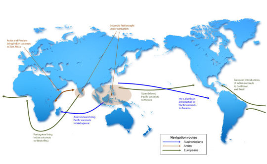
Coconut has a long and respected history among cultures in the regions of Southeast Asia, South Asia and the Pacific. DNA analysis reveals that coconuts were first cultivated in island Southeast Asia, meaning the Philippines, Malaysia and Indonesia, and perhaps the continent as well.
Coconuts were introduced to the Indian Ocean a couple of thousand years ago by ancient Austronesians establishing trade routes connecting Southeast Asia to Madagascar and coastal east Africa. Coconut genetics also preserve a record of prehistoric trade routes and of the colonization of the Americas.
Plato mentions that there were “fruits which spoil with keeping, with which we console ourselves after dinner” in Atlantis. This could be a traditional fermented food eaten as a dessert, locally known as “tapai”.
“Tapai” is indigenous and popular throughout Southeast Asia. It is a sweet or sour alcoholic paste and can be used directly as a food or in traditional recipes.
“Tapai” can be made from a variety of carbohydrate sources, but typically from cassava, white rice or glutinous rice. Fermentation is performed by a variety of moulds by inoculating a carbohydrate source with the required microorganisms in a starter culture, locally known as “ragi”, and yeasts, along with bacteria. “Tapai” is also used to make alcoholic beverages locally known as “arak” or “brem”.
Plato mentions that “there were roots, or herbage, or woods, or essences which distil from fruit and flower.” This could be the herbal medicine made from natural materials, locally known as “jamu”, or mixtures of spices or seasoning, known as “bumbu”.
“There was ‘fruit’ which admits of cultivation, both the dry sort, which is given us for nourishment and any other which we use for food – we call them all by the common name ‘pulse’.” This could be the paddy or rice, which is the staple food of the region.
“There were chestnuts and the like, which furnish pleasure and amusement.” This could be coffee, which grows well in this region.
19. Gold
(Critias: 114e, 116c, 116d)
20. Silver
(Critias: 114e, 116c, 116d, 116e)
21. Tin
(Critias: 116b, 116c)
22. “Brass”/“bronze” (copper, tin and zinc)
(Critias: 116b, 116c)
23. “Orichalcum”, more precious mineral than anything except gold, flashing, red color
(Critias: 114e, 116c, 116d)
24. “Orichalcum” was dug out of the earth in many parts of the land.
(Critias: 114e)
Atlantis had abundance of minerals: gold, silver, copper, tin and “orichalcum”. These are also true natural characteristics of the region.
What is “orichalcum”? “Orichalcum” was unknown to Greek, being more precious in those days than anything except gold and “flashed” with the “red light”, or like fire.
The author identified “orichalcum” as the zircon as they have the same characteristics as the descriptions. The zircon products are really valuable second to gold; they have gemstone quality and are popular as diamond simulant. Zircon can be processed to bring out different colors, the red one is known as the “hyacinth”. When finished, its nature is sparkling like diamond that metals do not possess, which why Plato describes it with the words “flashed” and “light”, in particular. No known metal shines and flashed with the red color, or like fire, thus “orichalcum” is not a metal.
The expression that it was “dug out of the earth in many parts of the land” is true as it is abundant in the region of Kalimantan.
25. Immediately about and surrounding the city was a level plain.
(Critias: 118a)
26. The plain was smooth and even.
(Critias: 118a)
27. The plain was surrounded by mountains which descended towards the sea.
(Critias: 118a)
28. The plain looked towards the south, sheltered from the north.
(Critias: 118b)
29. The mountains surrounding the plain celebrated their number, size and beauty, with many wealthy villages of country folk, rivers, lakes and meadows.
(Critias: 118b)
30. Plenty of wood of various sorts on the plain – abundant for each and every kind of work.
(Critias: 118b)
Plato describes that there was “a level plain, smooth and even, descended towards the sea”, “surrounded by mountains celebrated for their number, size and beauty”, “looked towards the south and sheltered from the north” and “with wealthy villages of country folk, rivers, lakes, and meadows”.
There was a plain near the capital city of Atlantis matching the characteristics of the region in southern Kalimantan in which a part is now submerged under the Java Sea. The plain has slopes mostly less than 1% declining southward to the Java Sea and no visible mound on the whole plain. It is open on the south and sheltered by the Muller-Schwaner and Meratus Mountains at the north, mostly covered by primary forest, inhabited by enormous kinds of animals and as the home of tens of native Dayak tribes. It has high rainfall and warm temperature over the year, many large rivers and tributaries so that it is very fertile and rich of food and daily necessity resources.
31. The general shape of the plain was rectangular and oblong.
(Critias: 118a, 118c)
32. The plain was extending in one direction 3,000 stadia (± 555 km), across the center inland 2,000 stadia (± 370 km).
(Critias: 118a)
Plato explains that the plain was “rectangular and oblong in shape, 3,000 stadia or about 555 kilometers long and 2,000 stadia or about 370 kilometers wide”. The shape of the plain in the region of southern Kalimantan and the adjacent Java Sea is rectangular at the south and oblong at the north, almost exactly 555 kilometers long and 370 kilometers wide.
33. The perimeter ditch was incredible in size, unexpected that they were artificial.
(Critias: 118c)
34. The perimeter ditch was 100 ft (± 30 m) deep, 1 stadium (± 185 m) wide, 10,000 stadia (± 1,850 km) long.
(Critias: 118c)
35. The perimeter ditch received streams from the mountains.
(Critias: 118d)
36. The inland canals were straight, about 100 ft (± 30 m) wide, 100 stadia (± 18.5 km) intervals and let off into the perimeter ditch.
(Critias: 118d)
Concerning the waterways on the plain, Plato describes that “the perimeter canal was 100 feet or about 30 meters deep, 1 stadium or about 185 meters wide, 10,000 stadia or about 1,850 kilometers long, carried round the whole plain, received streams from the mountains, winding around the plain, meeting at the city and let off into the sea.” and “the inland canals were straight, 100 feet or about 30 meters wide, 100 stadia or about 18.5 kilometers intervals and let off into the perimeter canal.”
There were waterways on the plain matching the characteristics of the region. The rivers of Barito, Kapuas-Murung, Kahayan and Sebangau found in the region are identified as those canals. They are originated from the Muller-Schwaner and Meratus mountains. These rivers are about 600 to 800 meters wide and 8 meters deep in average.
Flooding and sedimentation of the rivers on a very flat plain over the past 11,600 years have changed their regimes. Interchanges of flows and orders among them might also occur. However, in general view their straightness and elongation are preserved until today, that are parallel to each other and in the north-south direction.
Calculating the conveying capacity, that is the area × the velocity, and assuming the same flow velocity because of the same gravitational energy slope, the cross section area of the flow, that is the width × the depth, as described by Plato is about 185 × 30 = 5,550 square meters. While the area today is amazingly almost precise, 700 in average × 8 = 5,600 square meters.
The average distance of these rivers is approximately 20 kilometers, also considered in close agreement to the figure of 18.5 kilometers by Plato.
37. Transverse passages were cut from one inland canal into another.
(Critias: 118e)
Looking at the maps we can see numerous existing transverse passages in the region, some of them were built or rehabilitated in recent times. The passage is known locally as “anjir”, a canal linking two rivers as part of the transportation network.
38. The inland canals and transverse passages were means for transporting wood and products in ships.
(Critias: 118e)
Most of the rivers in southern Kalimantan are navigable. These rivers and all their tributaries are a network of transportation system, become very important means for the people and has been the economic lifeblood because most of their economic activities are carried out through and in the rivers since the ancient time. Various types of forest, mining and agricultural products are transported to collection points or ports through the river network.
39. Irrigation streams were tapping from the canals.
(Critias: 118e)
40. The irrigation streams supplied water to the land in “summer” (dry) but rainfall in the “winter” (rainy) yielding two crops in a year.
(Critias: 118e)
Today’s practices of tidal swamp irrigation system in southern Kalimantan is traditionally known as the “anjir system” where primary canals called “anjir” or “antasan” were constructed connecting two tidal rivers, also used as navigation purposes. Inland canals were built to irrigate and drain the fields from and to the anjir: secondary canals called “handil” or “tatah” and tertiary canals called “saka”. During low tides, the canals drain the toxic water while during high tides fresh water enters the canals and conveyed to the fields. The system yields two rice crops in a year.
41. The island city was in a sea surrounded by a boundless continent, the other is a real ocean.
(Timaeus: 25a)
42. The city was in front of a strait.
(Timaeus: 24e, 25a)
43. There were some islands in the sea.
(Timaeus: 24e – Critias: 114c)
Plato says that “the capital island where there was a city with a citadel and rings of water was in a real sea inside a strait surrounded by a boundless continent.” The boundless continent is the Sundaland attached to the Asian Continent, and the only sea surrounded by it in those days was the ancient Java Sea, suggesting that the capital island and city are located in the Java Sea.
44. Immediately about and surrounding the city was a level plain and all the canals met at the city and drained into the sea.
(Critias: 118a, 118d)
45. A small hill (the central island) and a vast level plain near the sea were accessible by ships, vessels and boats from the sea.
(Critias: 113c, 113e)
The statement that “the island was located near the plain and all the canals met at the city and drained into the sea”, suggesting that the island is located south of the plain, in a place now under the Java Sea.
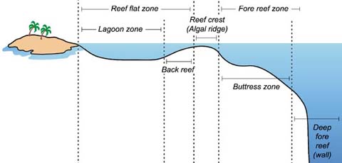
The site is identified by the sailors as Gosong Gia or Annie Florence Reef, a coral reef described as small in extent and dries at low water.
The city of Atlantis was an island with a small hill near its center. The city and the island existed long enough for many kings to develop it. It had rings of water and a passage from the sea to the inner ring. They bridged over the zones of sea which surrounded the ancient metropolis. A stone wall began at the sea and went all round. They used orichalcum, tin and brass or bronze to cover the outer walls of their cities.
There was a hill, not too high, near the middle of the center island. At the top of the central hill, a temple was built to honor Poseidon, which housed a giant gold statue of him. They built the palace in the habitation of the god and of their ancestors, which they continued to ornament in successive generations.
The later docks had triremes and many naval supplies.
46. The sea at the Atlantis city “is now” (Solon’s time) impassable and impenetrable because of a “reef of clay/mud” (coral reef), caused by “subsidence” of the island (sea level rise).
(Timaeus: 25d)
47. The ruin of the city is now under the sea.
(Timaeus: 25d)
The phrase “for which reason the sea in those parts is impassable and impenetrable, because there is a reef of mud, or clay, in the way” confirms the location. Coral reef is scarce in the Mediterranean so that the Greeks and the Egyptians did not own the term, then Plato wrote it as “a reef of mud, or clay”.
Coral reefs grow best in warm, shallow, clear, sunny and agitated waters, and on hard, underwater surfaces, thus constitute the ideal conditions for the Java Sea. It is confirmed further by the phrase “caused by the subsidence of the island”, as the growth of the coral reef was caused by the sea level rise during the last glacial period.
The sea level kept rising until about 6,000 years ago. Corals grew on the solid structures. Along with sedimentation and other processes.
Today, there is an existing coral reef named Gosong Gia or Annie Florence Reef in the Java Sea. The top of the reef is about 10 meters below the average sea level, and the surrounding sea bed is about 55 meters below the average sea level. The city structures are still apparent from the patterns of the reefs. The depth of the sea here exactly coincides the land level about 11,600 years ago. However, further investigations are required to find out what are inside the coral reef.
48. The city was beyond bordering monuments, the (ancient) Greek called them “the Monuments of Heracles”.
(Timaeus: 24e, 25c – Critias: 108e, 114b)
Plato mentions that “the war was said to have taken place between those who dwelt outside the Monuments of Heracles and all who dwelt within them.” Heracles is a name borrowed from the Greek mythology.
What does the “Monuments of Heracles” really mean? The Egyptian priest told Solon about the territorial boundary between Atlantis and its opponent as “which are by you called the Monuments of Heracles” to describe a state entrance or boundary markers which were situated in a strait. The words “by you” could mean that the markers were commonly known by the Athenian but not necessarily what they referred to, or in other words “like the Monuments of Heracles”. As mentioned before, the Atlantean boundary is not compatible with the Mediterranean region. Moreover, Solon borrows Greek mythological terms in the story.
Classical Greek writers frequently refer to the monuments without being in anyway specific regarding their location. The poet Pindar would appear to have treated the monuments as a metaphor for the limit of established Greek geographical knowledge, a boundary that was never static. The monuments were, in earlier times, identified with the Strait of Sicily, but from the time of Erastosthenes, circa 250 BC, the metaphor was moved to refer to the Strait of Gibraltar, reflecting the expansion of the Greek maritime knowledge.
The author hypothesizes that the monuments are monuments built at places on state entrances or boundary line and could be anywhere at certain places along the boundary. The monument is locally known as “tugu”, which has been the tradition in Indonesia until now to mark the boundary or entrances of a region. The monuments are often decorated with gargoyle-like faces of the god Kala, which are ubiquitous in Java and Bali.
It will be discussed later that the god Kala is analogous with the Greek Heracles.
49. Hot and cold springs
(Critias: 113e, 117a)
50. White, black and red stones
(Critias: 116a, 116b)
51. Hollowed out rock for roofs of double docks
(Critias: 116a, 116b)
Bawean Island off in the Java Sea is a prototype of the island of Atlantis as it has the same environment, geological formation and tectonic processes, as well as they are closely situated. Bawean and Atlantis islands are both located on a geological arc identified by the geologists as Bawean Arc.
It is described that “they had springs, one of cold and another of hot water”. There are several hot and cold springs in the Bawean Island resulted from the tectonic activities in the region.
The descriptions “the stones were quarried from the center island and the zones, with white, black and red colors” and “they hollowed out double docks, having roofs formed out of the native rock” are also noticeable. The stones are apparently similar to the igneous rock deposited in the Bawean Island having the acidic white, alkaline black-grey and ferro-oxide red rocks. This igneous rock is hard and strong having enough natural strength to stand as roofs of the hollowed out double docks.
52. “Poseidon” (sea or water god, law founder, driving sea creatures, supreme god in earlier time)
(Critias: 113c to 113e, 116c, 116d, 117b, 119c, 119d)
The kingdom of Atlantis was founded by a god named Poseidon, borrowed from the Greek myth. The land was divided into ten portions given to his children. There was a holy temple dedicated to Poseidon and his wife, Cleito in the center of the citadel.
Poseidon is one of the twelve Olympian deities of the pantheon in the Greek mythology. His main domain is the ocean, so that he is called the “God of the Sea”, who rides on sea creatures that resemble horses. In the earliest works of the ancient Greek literature, Poseidon is more widely known than Zeus and was regarded as the supreme god, as mentioned in Linear B tablets from the pre-Olympians Greek Bronze Age. Homer in the Iliad calls him as the protector of the Hellenic cities.
Poseidon is analogous to Nethune in the Etruscan civilization, around the 1st century BC, which is also called the “God of the Sea”. In Latin language, the name was transformed into Neptune in the Roman mythology. Neptune is depicted as a god who drive sea creatures resembling dragon-tailed horses and armed with a trident, like Poseidon. This shows the strong influence of Greek mythology.
Plato explains that the ten kings were said to have the absolute control of the citizens, by the enforcement of the law regulated by the command of Poseidon which had handed it down.
The Greek Poseidon is analogous to god Baruna or Waruna in the Nusantara archipelago which given the title of the “Water God”, the ruler of the seas and oceans. In pre-dharmic mythology, Baruna was considered as the supreme god against the others and the first law founder of the world.
Baruna is depicted as riding a sea monster called Makara, in which on the front resembling a beast, with large teeth and tusks, and on the back in the form of a giant dragon’s tail, occasionally legged. In Indian mythology, the Makara is described as an inland creature in the front half, such as deer, crocodile or elephant, and an aquatic creature in the back half, such as fish or seal, or occasionally peacock’s tail or flower.
Of these things, the author concludes that Poseidon and Baruna are analogous, evidenced that both of them are the gods of the seas or oceans, became the first law founders, constituted the supreme gods in the early time, and drive mythological sea creatures.
Besides some other names, Kalimantan bore the name of Warunapura, means the land of the god Baruna. The old Javanese chronicle Nagarakretagama mentions an ancient state that was within the Majapahit spheres of influence called Baruné, later identified as Barunai, a kingdom of the modern Brunei. European sources further in the 16th century showed the name of the island as Burné by Antonio Pigafetta or Bornei by Duarte Barbosa. Chinese chronicles in the Song and Ming dynasties showed the name Boni. The Dutch and British colonials named the island as Borneo.
This is another conclusion that Kalimantan, or Borneo, which was once the island of the god Baruna, is analogous to the island of Poseidon, and related to the existence of Atlantis in the region.
53. “Heracles” (son of the supreme god, outrageous birth, has insatiable appetites and being very rude, brutal and violent)
(Timaeus: 24e, 25c – Critias: 108e, 114b)
Heracles, or Romanized as Hercules, is the son of the affair Zeus had with the mortal woman Alcmene. Zeus seduced and made love to Alcmene after disguising himself as her husband, Amphitryon, the king of Thebes. Zeus swore that the next son born of the Perseid house should become ruler of Greece, but by a trick of Zeus’s jealous wife, Hera, another child, the sickly Eurystheus, was born first and became king. When Heracles grew up, he had to serve him and also suffer the vengeful persecution of Hera. Besides these Hera induced frenzies, Heracles was a very brutal character.
The Greek Heracles is analogous to god Kala in the Nusantara archipelago. Kala is a god of the underworld in the ancient Javanese and Balinese mythology.
According to the Javanese legend, Kala is the son of Guru. Guru has a very beautiful wife named Uma. One day Guru, in a fit of uncontrolled lust, forced himself on Uma. They had sexual intercourse on top of his Andini, a divine cow. This behavior was ashamed Uma who then cursed Guru but Guru cursed back Uma so she appeared as a fearsome and ugly ogre. This fierce form of Uma is also known in Javanese mythology as Durgha. From this relationship, Kala was born with the appearance of an ogre.
Kala is described as having an insatiable appetite and being very rude. He was sent by the deva to Earth to punish humans for their evil habits. However, Kala was interested only in devouring humans to satisfy his appetite. Alarmed, the deva then recalled Kala from the Earth. He later became ruler of the underworld.
The analogy of Kala and Heracles is that each of them is the son of a supreme god, either Guru or Zeus. Their births were outrageous; Kala was born from an uncontrolled lust of Guru on Uma while Heracles was from a seduction of Zeus on Alcmene. They are having insatiable appetites and being very rude, brutal, and violent in their whole lives.
From the ancient until present day, gargoyle-like faces of Kala are often found at temple entrances, boundary monuments, welcome monuments, gates, doorway, niches, furniture, wall hangings and traditional musical instruments; ubiquitous in Java and Bali. Similar figures are also found at the Dayak houses.
As previously discussed, the boundary monuments decorated with the Kala faces are analogous to the Monuments of Heracles.
Apart from those, Zeus, the father or Heracles, and Guru, the father of Kala, are also analogous. Both of them were then appointed to the supreme gods replacing either Poseidon or Baruna.
Note also the analogy and phonetic similarities between the names, Kala and Kleos, Guru and Zeu, Uma with Alkmene, and Durgha with Hera.
54. “Bull” sacrifices
(Critias: 119d to 120c)
Plato describes that in every five or six years alternately, the kings of Atlantis gathered to discuss and make arrangements, topped off with plenty of “bulls” sacrifice.
Common people generally could not distinguish between “bull” and “water buffalo”. Plato does not recognize “water buffalo” but beast resembling the “bull” because the animals were not found in the ancient Greece and its surroundings.
Water buffalo, also called Asian buffalo or Asiatic buffalo, is a large bovine native to Southeast Asia and the Indian Subcontinent. Water buffalo is one of the animals of greatest economic and religious value used as a sacrificial victim in Southeast Asia, Indian sub-continent and southern China. In these monsoon regions of Asia, buffalos are offered in sacrifice to divinities or divine spirits, as the carrier of dead souls to the world beyond or of zoomorphic symbol of the ancestors.
A characteristic of Southeast Asian houses is the forked horn on the roof, which is considered to be a symbol of the buffalo, regarded throughout the region as a link between heaven and this world.
55. Temple or pyramid
(Critias: 116c, 116d, 116e, 117c, 119c)
The construction of stone pyramids was based on native belief that mountains and other high places are the abode of the spirits of the ancestors, or the most ideal pilgrimage places to worship them.
The simplest form of pyramid is the earth-and-stone step pyramids in which it is normally built on natural or manmade mounds, hills or hillsides. Usually there is a shrine and/or an altar at the top.
Austronesian megalithic culture in Nusantara features an earth and stone step pyramid structure, referred to as “punden berundak”. “Punden berundak” is regarded as one of the characteristics of the original culture of the archipelago. Pyramid structures have been found and spread throughout Southeast Asia, most of them are found in the island of Java.
The huge Borobudur temple is the largest Buddhist temple in the world, which allegedly built on the previous step pyramid. The Sukuh and Cetho temples in Central Java, where the dates are still debated, show the Austronesian indigenous earth-and-stone step pyramids that somewhat resemble Mesoamerican pyramids. Gunung Padang is the biggest and the oldest megalithic site in Southeast Asia dated circa 23,000 BC or older.
As the civilizations were developing, they built larger pyramids so that more stones were required. The majority of the weight are closer to the ground and material higher up on the pyramid will be pushing down from above. The stones could pose problems on the strength of the earth to hold the weight. Therefore, pyramids with heavier stone weight pushing on the earth fill are observed to have less earth fill or even without it.
Pyramids have been built by civilizations in many parts of the world. For thousands of years, the largest structures on Earth were pyramids. They spread from Egypt to America, that emerged separately from one another by oceans who supposedly never discovered each other’s existence. There are no firmly established connections between the different civilizations that built them, but their similarities show that they sprang from a common origin.
As said by Plato, the temple of Poseidon was built in the center island which was a hill, encircled by rings of waters. To reach the temple from the innermost ring of water, steps on the hill slope were definitely required. This could mean that the temple is featuring an earth-and-stone step pyramid structure, characterizes the original culture of Nusantara that is referred to as “punden berundak”. The temple was also the place to worship their ancestors.
Plato describes that the canals were means for transporting wood and products in ships. They brought down the wood from the mountains to the city, and conveyed the products of the earth in ships. The canal and the largest of the harbors were full of vessels and merchants coming from all parts. The docks were full of triremes and naval stores. They had a fleet of as many as 1200 ships.
Maritime activity is a typical Austronesian culture since the ancient time. The earliest known evidences are found as cave paintings dated back to 10,000 years or older, those are fully decorated by sailboat paintings. Long distance sailing technology in the region must have appeared much earlier, with the peopling of Australia through Southeast Asia some 40,000 years ago. Archaeologists have revealed ample evidence of the active maritime networks in the Southeast Asia region, that spread throughout all of insular Southeast Asia and most of the Pacific.
57. Advanced civilization in the era
(Timaeus: 24e, 25a)
Plato describes that Atlantis was a great and magnificent kingdom that had vast powers. Atlantis can be said to be an advanced civilization of its time, and had a variety of superior technologies compared to other countries.
Gunungpadang pyramid in Java is the oldest known structure of any kind on Earth. Dated to as early as 25,000 years ago, the pyramid would be proof of an advanced ancient civilization. The majority of the stepped site is man-made, built by generations over a matter of millennia.
The so many rock paintings depicting sailboats in Southeast Asia, dated to as early as 40,000 years ago, would also proof that such technology has been mastered from the early time. This technology had been inherited by the Austronesian people and the thalassocracies, or maritime kingdoms, such as Srivijaya and Majapahit. The Bugis and Makassar people from the island of Sulawesi are renowned for making a wooden sailing vessel called the “pinisi”.
The kingdoms in Southeast Asia developed an advanced stone mason architectural technology in building of temples. This includes the magnificent Borobudur, Prambanan, Angkor Wat and many other couple hundreds of temples.
In agriculture, the people in Southeast Asia are famous for paddy cultivation and techniques such as terracing. Local systems of complex irrigation and water management have been developed in the archipelago. An exceptional example is Subak, the irrigation system of Bali.
In food technology, due in part to the tropical climate teeming with various microbes, the people in Southeast Asia have developed traditional knowledge in fermentation techniques, which resulted in the development of fermented foods such as “tapai”, “tempeh”, “oncom”, and also beverages like “brem” and “tuak”.
58. Destructed 9,000 years before Solon (about 11,600 years ago)
(Timaeus: 23e – Critias: 108e, 111a)
Plato describes that Atlantis was a powerful and advanced kingdom that destructed, in a night and a day, 9,000 years before Solon, or about 11,600 years ago. This accurately coincided with the cataclysm at the end of the Younger Dryas period.
At the end of the Younger Dryas period, around 11,600 years ago, the weight of the ice shifted to the seas triggered cracks in the earth’s crust to move, that set off cataclysm. Earthquakes, volcano eruptions, super waves and floods engulfed the coastal cultures and all the flat continental shelves of Sundaland, and wiped out many populations. As the sea rolled in, there was a mass migration of the survivors from the sinking continent.
59. Earthquakes and “floods” from the sea (tsunami)
(Timaeus: 25c, 25d – Critias: 108e, 111a, 112a)
Plato mentioned that the island of Atlantis was beset, in a night and a day, by an earthquake and a flood. In some other his explanations, it is implied that the flood was coming from the sea, so the possibility is a tsunami. Plato did not recognize “tsunami” so he equated it to “flood”. Earthquakes and tsunamis are very often correlated.
Frequent and significant earthquakes, tsunamis and volcano eruptions took place in one of this most complex tectonic region on Earth. Tsunami are known for their dramatic run-up heights, can also be excited or amplified in height considerably in shallow waters and on flat plains, and can oscillate back and forth within harbors and bays.
We could speculate that the destruction of Atlantis was among others caused by a tsunami in this region. It was due to the tsunami waves traveling in shallow water, that was the ancient Java Sea, and penetrated inland on a very flat plain. The ancient Java Sea was forming a gulf, which could cause the wave became much higher and prolonged, and destructive.
Plato describes that the lands of Atlantis and “the Athens” were sunken ceaselessly afterwards. This is in line with the recent knowledge of post-glacial sea level rise. The sea level kept on rising until about 6,000 years ago, sinking the low lands as well as low plains in Sundaland.
The ruin of the Atlantis city and its story were buried forever under the sea. Then, it was remembered by the Egyptians who migrated from there, and wrote them on their sacred registers.
From Plato’s Timaeus Section 25d: “For which reason the sea in those parts is impassable and impenetrable, because there is a shoal of mud in the way; and this was caused by the subsidence of the island.”
“A shoal of mud” is the generally published translation of the Ancient Greek phrase “πηλοῦ κάρτα βραχέος” written by Plato. “κάρτα βραχέος” is not syntactically good and it is not found in any manuscript; “πηλός” is masculine and is the antecedent of the relative pronoun; “κατὰ βραχέος”, for its turn, is adverbial. The simple meanings of the words are: πηλοῦ for “clay” or “mud”, κάρτα for “very” and βραχέος for “shoal” or “reef”. Other alternative translation is “the clay that exists in large quantity there and of the small depth” (Lopes, 2011).
The author translated πηλοῦ κάρτα βραχέος into “coral reef” for the reason that this sea formation is scarce in the Mediterranean so that the Greeks and the Egyptians did not own the term. The Mediterranean no longer shelters the great coral reefs that thrived 60 million years ago. This is due to millennia of climactic and oceanographic changes. Today, there are only a few species of colonial anthozoans that have the capacity to create the coral reefs. In 2010, the exploration vessel Nautilus has discovered for the first time an area of reefs with deep-sea corals in the Mediterranean, offshore of Israel. This area apparently stretches over a few kilometers, 700 meters under the surface and some 30 – 40 km off the coast.
In the above Plato’s account, the citadel of Atlantis was impassable and impenetrable at the time of Solon (about 600 BC) because of the growth of a coral reef caused by sea level rise during the Ice Age (“subsidence of the island”). The present condition of the hypothesized site is that there is a coral reef identified by the sailors as Gosong Gia or Annie Florence Reef, a coral reef described as small in extent and dries at low water.
Coral reefs are diverse underwater ecosystems held together by calcium carbonate structures secreted by corals. Coral reefs are built by colonies of tiny animals found in marine waters that contain few nutrients. Most coral reefs are built from stony corals, which in turn consist of polyps that cluster in groups. The polyps belong to a group of animals known as Cnidaria, which also includes sea anemones and jellyfish. Unlike sea anemones, corals secrete hard carbonate exoskeletons which support and protect the coral polyps. Reefs grow best in warm, shallow, clear, sunny and agitated waters.
Often called “rainforests of the sea”, shallow coral reefs form some of the most diverse ecosystems on Earth. They occupy less than 0.1% of the world’s ocean surface, about half the area of France, yet they provide a home for at least 25% of all marine species, including fish, molluscs, worms, crustaceans, echinoderms, sponges, tunicates and other cnidarians. Paradoxically, coral reefs flourish even though they are surrounded by ocean waters that provide few nutrients. They are most commonly found at shallow depths in tropical waters, but deep water and cold water corals also exist on smaller scales in other areas.
Coral reefs begin to form when free-swimming coral larvae attach to submerged rocks or other hard surfaces along the edges of islands or continents. As the corals grow and expand, reefs take on one of three major characteristic structures – fringing, barrier or atoll. Fringing reefs, which are the most common, project seaward directly from the shore, forming borders along the shoreline and surrounding islands. Barrier reefs also border shorelines, but at a greater distance. They are separated from their adjacent land mass by a lagoon of open, often deep water. If a fringing reef forms around a volcanic island that subsides completely below sea level while the coral continues to grow upward, an atoll forms. Atolls are usually circular or oval, with a central lagoon. Parts of the reef platform may emerge as one or more islands, and gaps in the reef provide access to the central lagoon (Lalli and Parsons, 1995; Levinton, 1995; Sumich, 1996 as cited by NOAA).
In addition to being some of the most beautiful and biologically diverse habitats in the ocean, barrier reefs and atolls also are some of the oldest. With growth rates of 0.3 to 2 centimeters per year for massive corals, and up to 10 centimeters per year for branching corals, it can take up to 10,000 years for a coral reef to form from a group of larvae (Barnes, 1987 as cited by NOAA). Depending on their size, barrier reefs and atolls can take from 100,000 to 30,000,000 years to fully form.
The citadel of Atlantis consisted of hard surfaces so that a coral reef began to form in a while after its submergence, grows and expands as commonly found at shallow depths in tropical waters. Any underwater explorations may not find the citadel unless they made investigations under the reef.
The rate of seawater rise in the Last Glacial Period is in average 0.6 centimeter per year. Because of the warm water at the hypothesized site, the growth rate of the coral reef is expectedly higher than the rate of seawater rise. Accordingly, the vertical growth rate of the coral reef at the site is parallel to the seawater rise.
The sea level kept rising until about 6,000 years ago. Corals grew on the solid structures, along with sedimentation and other processes. There is an existing coral reef named Gosong Gia or Annie Florence Reef at a site in the Java Sea believed to be the location of the capital city. From an unpublished sonar survey of the site by a sponsor team, the top of the reef and the surrounding sea bed are about 10 and 55 meters below the average sea level, respectively. The city structures such as the hill, the circular wall, the circular channel and the bridge are still apparent from the patterns of the corals with exactly the same dimensions as those described by Plato. The depth of the surrounding sea here exactly coincides the land level about 11,600 years ago before the sea level rise. However, further investigations are required to confirm.
Citations
Rodolfo Lopes, Platão, Timeu-Crítias. Tradução do grego, introdução e notas, Centro de Estudos Clássicos e Humanísticos, 2011
Plato said in Critias Section 115b: “… and the fruits having a hard rind, affording drinks and meats and ointments …”
Coconut (Cocos nucifera) provides a nutritious source of meat, juice, milk, and oil that has fed and nourished populations around the world for generations. On many islands coconut is a staple in the diet and provides the majority of the food eaten. Nearly one third of the world’s population depends on coconut to some degree for their food and their economy. Among these cultures the coconut has a long and respected history.
Coconut is highly nutritious and rich in fiber, vitamins, and minerals. It is classified as a “functional food” because it provides many health benefits beyond its nutritional content. Coconut oil is of special interest because it possesses healing properties far beyond that of any other dietary oil and is extensively used in traditional medicine among Asian and Pacific populations. Pacific islanders consider coconut oil to be the cure for all illness. The coconut palm is so highly valued by them as both a source of food and medicine that it is called “the tree of life”. Only recently has modern medical science unlocked the secrets to coconut’s amazing healing powers.
Coconut oil is edible oil that has been consumed in tropical places for thousands of years. Studies done on native diets high in coconut oil consumption show that these populations are generally in good health, and don’t suffer as much from many of the modern diseases of western nations where coconut oil is seldom consumed anymore. Coconut oil is an excellent massage oil and smoothener for the skin. In the tropical parts of the world, natives commonly spread coconut oil on their skin, as they believe that it protects from the sun’s harmful rays. So this natural oil, without any chemical or additives, can protect the skin in some of the hottest and sunniest places on earth better than the processed and artificial sun creams.
The nutrient-rich coconut sap comes right out of the inflorescence of the tree is naturally abundant in 17 amino acids (the building blocks of protein), broad-spectrum B vitamins (especially rich in inositol, known for its effectiveness on depression, high cholesterol, inflammation, and diabetes), vitamin C, minerals (high in potassium, essential for electrolyte balance, regulating high blood pressure, and sugar metabolism), as well as FOS (fructooligosaccharide, a prebiotic that promotes digestive health). Coconut tree sap produces a multitude of delicious products, including coconut vinegar, coconut amino seasoning sauce, coconut nectar, coconut sugar and coconut alcoholic beverage, all made through raw methods of either aging the sap for up to 1 year, or evaporating it at low temperature after it is collected.
Coconut sugar is produced by tapping the sap from the tree and boiling it down to produce syrup, which is then sold as is, or allowed to crystallize into various shapes and sizes. Coconut sugar is known in different names, in Indonesia as gula merah or gula jawa (Javanese sugar), Myanmar as htanyet, Cambodia as skor tnot, the Philippines as pakaskas, Malaysia as gula anau, Laos and Thailand as nam tan pip and Vietnam as đường thốt nốt.
Coconut milk is a very popular food ingredient used in Southeast Asia, South Asia, Southern China and the Caribbean. Traditionally, coconut milk is acquired through the grating of a brown coconut, mixing the resulting substance with a small amount of water to dissolve the fat present in the grated meat. The squeezed coconut meat is then soaked in water and squeezed further to produce thin coconut milk. Thick milk is mainly used to make desserts as well as rich and dry sauces. Thin milk is used for soups and general cooking. Unlike cow’s milk, coconut milk is lactose free so can be used as a milk substitute by those with lactose intolerance. It is a popular choice with vegans and makes a great base for smoothies, milkshakes or as a dairy alternative in baking.
Coconut water is the watery liquid that usually comes from the young, still immature green coconut, although mature coconuts also have coconut water. Coconut water is high in many vitamins and minerals, especially potassium. Because it contains electrolytes, it is considered one of the best natural rehydrating drinks in the tropics. The still jelly-like coconut meat is often added to coconut water to make a tropical drink. Coconut water has received a great deal of attention for it’s perceived health benefits, and is an important treatment for acute diarrhoea in the developing world. Research suggests the clear liquid has the same electrolyte balance found in isotonic drinks, proving useful for rehydration or after long periods of intensive exercise.
Coconut vinegar is similar to other fermented vinegars such as apple cider and balsamic vinegars. It can either be made with coconut water or from the sap of the coconut tree, left in the open air to ferment, where it eventually turns into a vinegar. Coconut vinegar is a staple condiment in Southeast Asia, and is also used in some regions of India. Coconut vinegar is white and cloudy with a very pungent acidic taste and a hint of yeast. As with apple cider vinegar, coconut vinegar includes the “mother”, or culture of organisms that caused the fermentation. Coconut vinegar is a food appropriate for diabetic patients, as it is very low on the glycemic index, coming in at only 35 on the scale.
Indonesian and Malaysian tuak or lambanóg in the Philippines is a distilled alcoholic drink made from fermented sap of coconut flowers. The clear distillate may be blended, aged in wooden barrels, or repeatedly distilled and filtered depending upon the taste and color objectives of the manufacturer.
DNA analysis of more than 1,300 coconuts from around the world reveals that the coconut was brought under cultivation in two separate locations, one in the Pacific basin and the other in the Indian Ocean basin (Baudouin et al, 2008; Gunn et al, 2011). What’s more, coconut genetics also preserve a record of prehistoric trade routes and of the colonization of the Americas. In the Pacific, coconuts were likely first cultivated in island Southeast Asia, meaning the Philippines, Malaysia, Indonesia, and perhaps the continent as well. In the Indian Ocean the likely center of cultivation was the southern periphery of India, including Sri Lanka, the Maldives, and the Laccadives. The Pacific coconuts were introduced to the Indian Ocean a couple of thousand years ago by ancient Austronesians establishing trade routes connecting Southeast Asia to Madagascar and coastal east Africa.
References
Luc Baudouin and Patricia Lebrun, Coconut (Cocos nucifera L.) DNA studies support the hypothesis of an ancient Austronesian migration from Southeast Asia to America, 2008. Springer Link, March 2009, Volume 56, Issue 2, pp 257-262.
Bee F. Gunn, Luc Baudouin and Kenneth M. Olsen, Independent Origins of Cultivated Coconut (Cocos nucifera L.) in the Old World Tropics, 2011. PLoS ONE 6(6): e21143. doi:10.1371/journal.pone.0021143.
Jones TL, Storey AA, Matisoo-Smith EA and Ramirez-Aliaga JM, Polynesians in America: pre-Columbian contacts with the New World, 2011. Lanham, MD: AltaMira Press.
Luc Baudouin, Bee F. Gunn and Kenneth M. Olsen, The presence of coconut in southern Panama in pre-Columbian times: clearing up the confusion, 2013. Annals of Botany: doi:10.1093/aob/mct244.
From Plato’s Critias Section 115b: “… and are fruits which spoil with keeping, with which we console ourselves after dinner …”
Tapai or tape made from cassava (left) and glutinous rice (right)
Tapai is a traditional fermented food as a dessert indigenous and popular throughout Southeast Asia. It is a sweet or sour alcoholic paste and can be used directly as a food or in traditional recipes. Tapai can be made from a variety of carbohydrate sources, but typically from cassava (Manihot esculenta), white rice (Oryza sativa) or glutinous rice (Oryza sativa glotinosa). Fermentation is performed by a variety of moulds by inoculating a carbohydrate source with the required microorganisms in a starter culture, locally known as ragi, including Aspergillus oryzae, Rhizopus oryzae, Amylomyces rouxii or Mucor species, and yeasts including Saccharomyces cerevisiae, Saccharomycopsis fibuliger, Endomycopsis burtonii and others, along with bacteria. Tapai is also used to make alcoholic beverages locally known as arak or brem.
Tapai is known in different names, in Indonesia as tape or tapai, Java as tapé, Sunda (western Java) as peuyeum, Malaysia and Brunei as tapai, Thailand as khao-mak, Cambodia as chao or tapai, and the Philippines as tapay or binuburang. Glutinous rice tapé ketan is a noted regale in Java during the idul fitri festival.