Plato’s tale of Atlantis, told in Timaeus and Critias, has fascinated readers for over two millennia. Yet Plato was not writing in a vacuum. Across the world, from India to Mesopotamia, from Egypt to Tamil traditions, we find stories that sound strangely familiar. These are not “proofs” of Atlantis, but parallels—echoes of catastrophe, paradise, or vanished lands.
Kumari Kandam (Tamil Memory of a Sunken Land)
The Tamil tradition speaks of Kumari Kandam, a lost landmass once ruled by the Pandyan kings. Ancient Tamil texts like Silappatikaram and Kaliththokai describe Sangam academies—gatherings of poets—some of which were said to have been drowned by the sea. Later Puranic texts placed Kumari Kandam in the deep south, now swallowed by the ocean.
It was imagined as a vast territory divided into 49 regions, crossed by mountains with 48 peaks, irrigated by channels from four great rivers. Mining of gems and gold was central. Eventually, the land was said to have been “swallowed by the sea” (Katalkol).
In modern times, revivalists fused this myth with the Victorian hypothesis of Lemuria, a now-abandoned scientific theory about a sunken Indian Ocean continent. Tamil nationalists embraced it as ancestral memory. In my earlier article on Lemuria, I showed how Kumari Kandam became conflated with Lemuria and even Mu, giving the myth a global spin.
Atlantis echo: A golden civilization, irrigated plains, gem mines, destroyed by rising seas.
Kangdez (Iranian Fortress-Paradise)
Iranian epic literature preserves the memory of Kangdez (Fortress of Kang). In the Shāhnāmeh and Bundahishn, Kangdez appears as a miraculous walled city in the Far East. Slides highlight its placement: “at the far eastern ocean, about six months to a year’s voyage from Iran, near the equator, outside China, east of India.”
Descriptions of Kangdez include concentric rings of walls layered with metals and precious stones, plentiful waters, eternal springs, and places of play, silver and gold towers, and a great plain influenced by the sea’s tides with rivers flowing south from volcano-studded mountains.
Atlantis echo: Both traditions emphasize concentric fortifications, gleaming metals, abundance of water, and a paradisal yet precarious geography.
Neserser (Egypt’s Island of Osiris)
In the Book of the Dead (Papyrus of Nu), we encounter Neserser—“the Island of Fire” in the far East, where the sun rises. It is the dwelling place of Osiris (Ausares, Asar) and Thoth. The imagery is vivid: Osiris enthroned in the center of six or seven concentric circles on a sacred lake, a volcanic-like “island and lake of fire” dedicated to Ra, floods that reshape the landscape, and Thoth residing nearby, keeper of divine knowledge.
Later Egyptologists described these circles as “hidden after the flood.”
Atlantis echo: Here again are concentric circles, a sacred island, a great flood, and divine kingship.
Mount Nisir (Mesopotamian Flood Memory)
The Epic of Gilgamesh recounts a great flood, where Utnapishtim builds an ark. After seven days, the boat grounds on Mount Nisir. Slides add color: the land in the Far East was like paradise, with forested mountains, rivers, vast plains, noisy birds, cicadas, and monkeys screaming in the trees.
This imagery is tropical—not the dry Mesopotamian steppe, but a lush, equatorial realm. Some scholars note that “Nisir” is phonetically close to “Neserser” and even “Nusasura.”
Atlantis echo: The flood, the grounding of survivors on a mountain, the paradise-like tropical plain.
The Asuras and the Ahuras
In early Vedic India, the Asuras were not evil—Varuna, guardian of cosmic law and the waters, was chief among them. Later texts, however, cast the Asuras as enemies of the Devas, while Varuna retained dignity as a god of oceans.
In Iranian religion, the cognate term Ahura (as in Ahura Mazda) was elevated as the supreme god, while the Daevas (same root as Devas) became demons.
India (early Vedas): Asuras = powerful lords, led by Varuna
India (later): Asuras = demons
Iran: Ahuras = good, Daevas = bad
Assyria: Ashur = supreme deity
Egypt: Osiris (Asar, Asari) = supreme deity with concentric-circle symbolism
Atlantis echo: The Atlantean kings were “Poseidon’s sons.” Poseidon parallels Varuna/Baruna, lord of seas and boundaries. The name “Atlas” recalls “Asura/Ashur/Osiris.” We glimpse a very old naming web that Solon may have repurposed.
“Atlas” and “Poseidon” as Borrowed Names
Plato openly said he borrowed names “to make the tale intelligible to his audience.” Thus Atlas and Poseidon may be Greek masks for older gods.
Atlas: The mountain-bearing Titan in Greek myth; but also linked to the root “Asura/Asar.”
Poseidon: God of seas and quakes, mirroring Varuna/Baruna/Vouruna—Indo-Iranian lords of waters and oaths.
These echoes suggest that Solon translated Near Eastern deities into Greek equivalents. The concentric rings, sacred kingship, and sea-lord all survive the translation.
The Garden of Eden
Finally, the Garden of Eden—a paradise watered by a river dividing into four: Tigris, Euphrates, Gihon, and Pishon. Genesis places Eden in the East, yet beyond ordinary geography. Some scholars argue Eden reflects older Mesopotamian “Dilmun” traditions—a far-off, pristine land. My 2015 article even suggested Kalimantan as Eden’s real-world counterpart.
Atlantis echo: Eden shares the archetype of a paradise lost—an ordered, fertile place destroyed or closed off after human transgression.
Gosong Gia and Nusantara Echoes
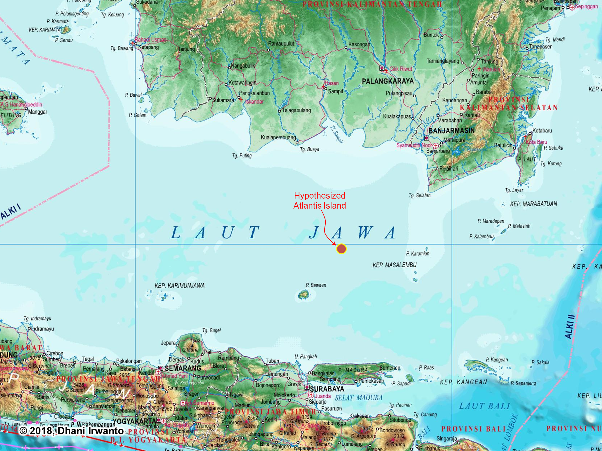
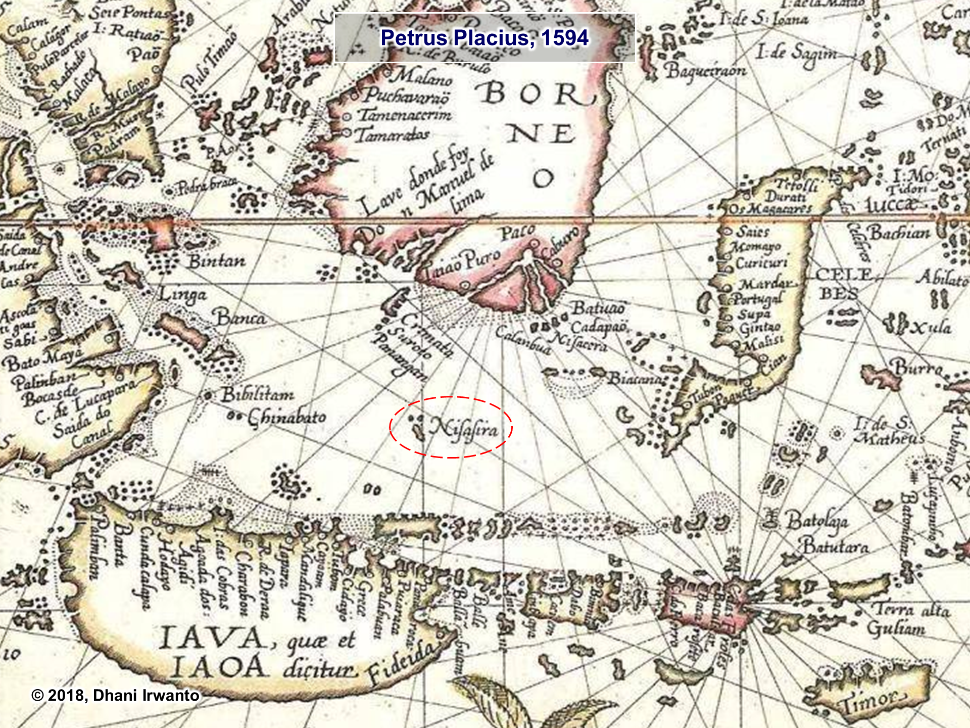
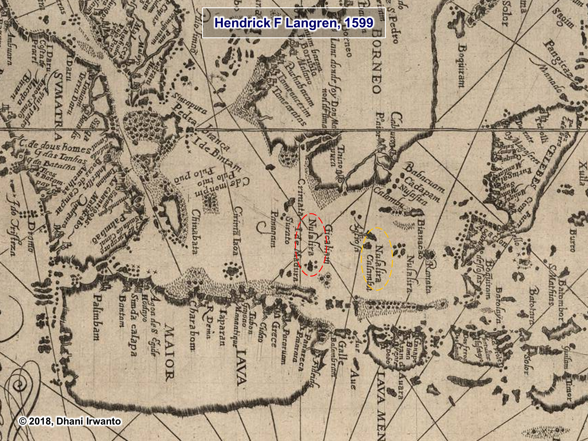
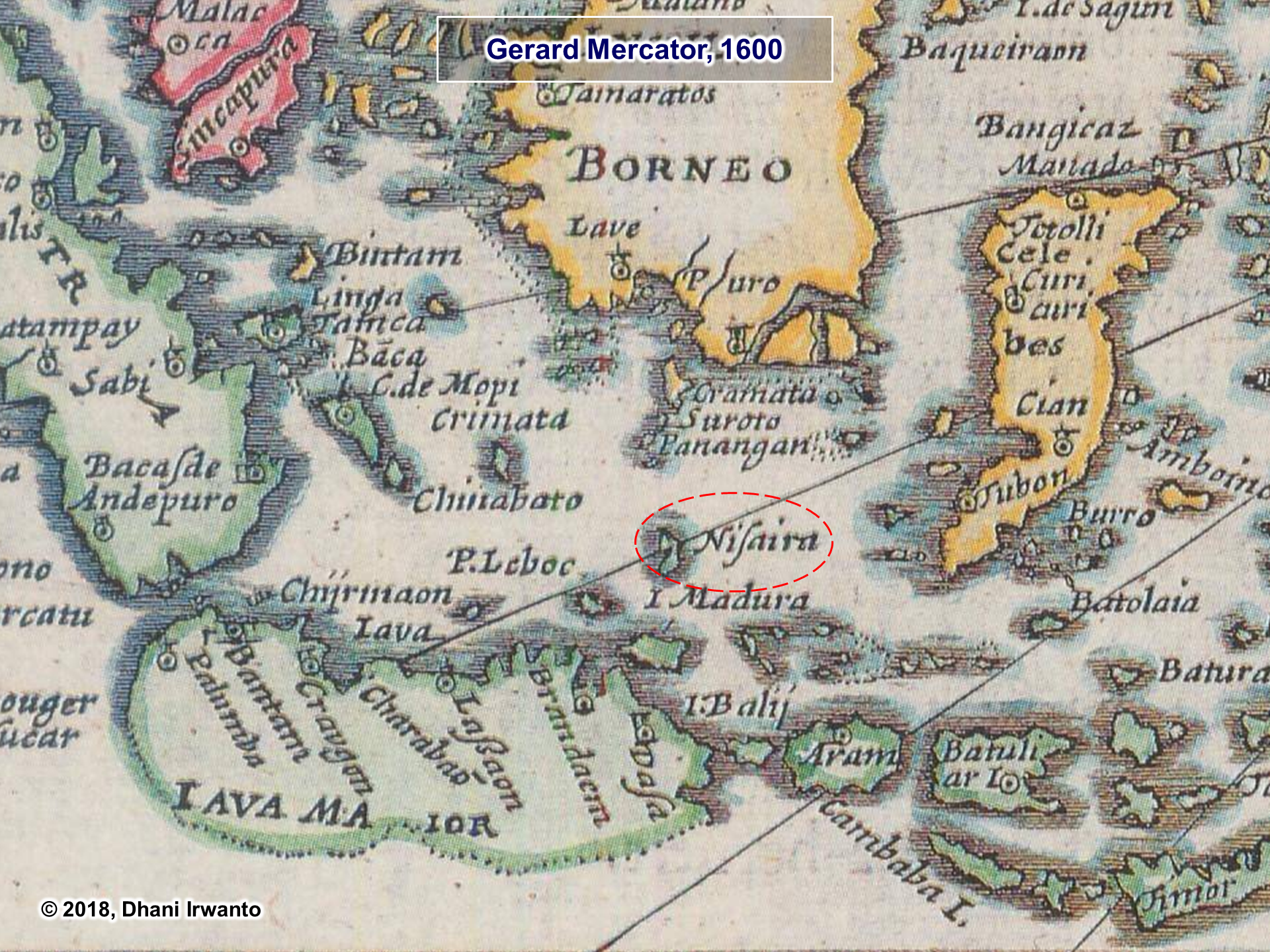
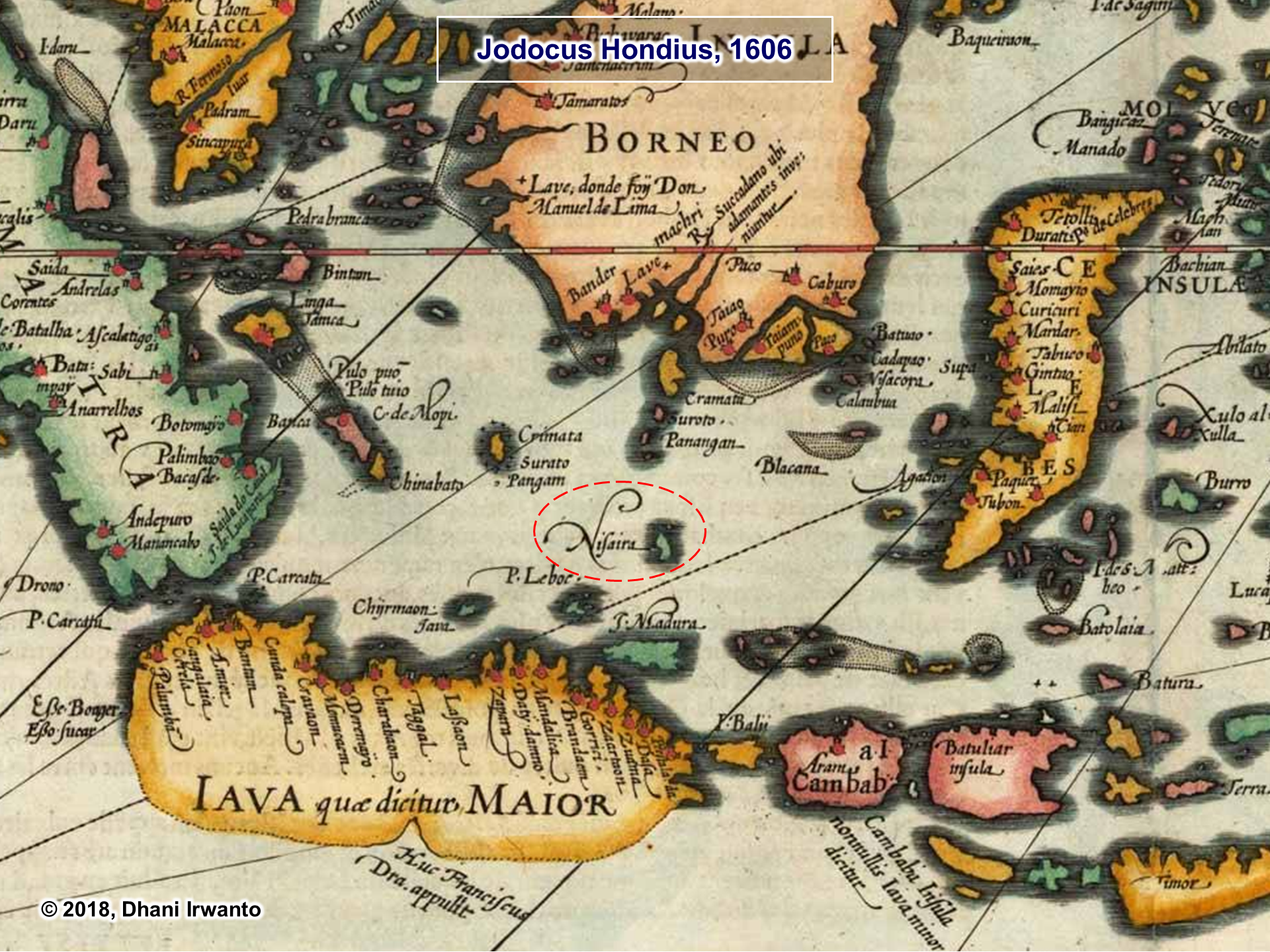
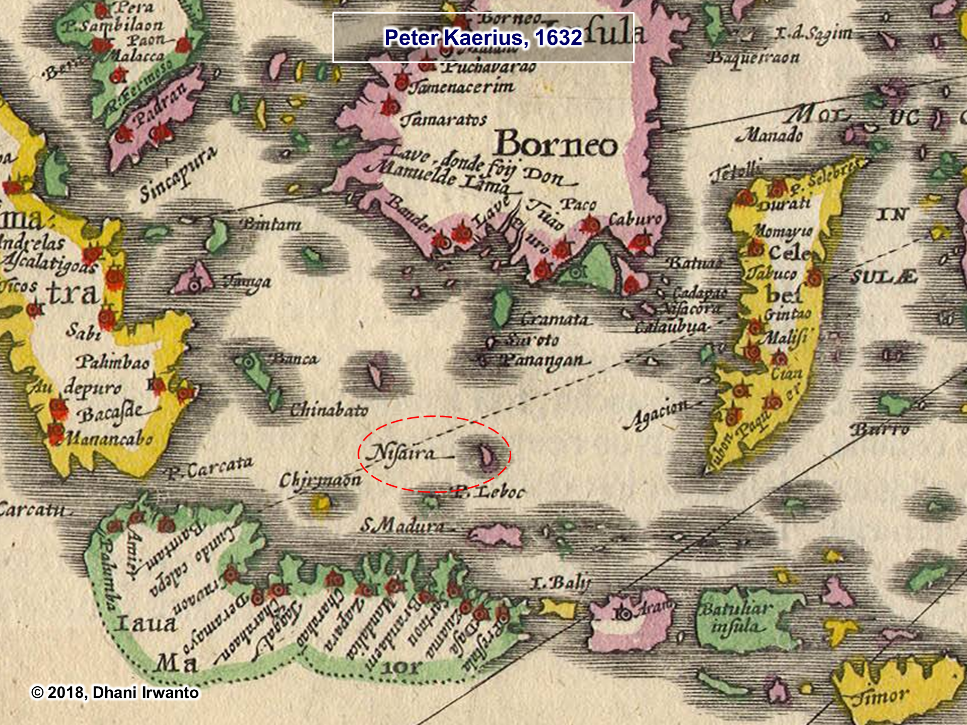
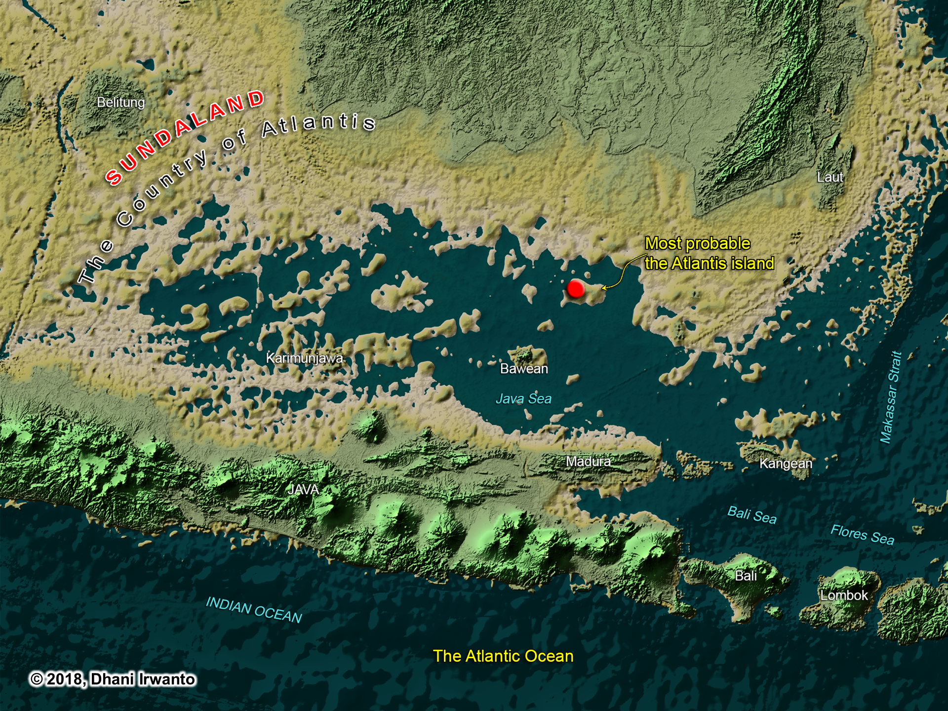
Slides mention Nusasura—possibly the “original name of Atlantis.” It combines nusa (island) and Asura. Old maps show names like Nusasira or Nisaira, perhaps distorted echoes. The Gosong Gia reef in the Java Sea is suggested as a drowned remnant. Even the people of Bawean Island hold myths of a sunken land.
Atlantis echo: If Atlantis lay in the Java Sea, Nusantara traditions like Nusasura may be its local survival in name.
Neserser, Punt, and Southeast Asia: The Egyptian Connection
Plato insists that his Atlantis story came from Egyptian priests at Sais, who told Solon the tale. If so, then the Egyptian worldview—their maps of trade, geography, and sacred memory—shaped what Plato inherited.
The Egyptians had firsthand knowledge of Southeast Asia, preserved in their accounts of the Land of Punt. Punt, described as the Ta Netjer or “land of the gods,” was not a vague myth but a real destination of repeated voyages, from Khufu to Rameses III. The great expedition of Hatshepsut (c. 1493 BCE) is famously carved on her temple walls, showing Egyptian ships sailing to Punt’s harbors.
Products: Gold, camphor (kapur barus), benzoin (kemenyan), cinnamon, ebony, nutmeg, short-horned cows, elephants, and macaques—all endemic to Sumatra and neighboring islands.
Architecture: Puntite houses on stilts match Sumatran and Enggano traditions.
People: Puntites depicted with lighter skin, straight noses, and Malay-style dress, jewelry, and weapons.
Names: Chief Parehu resembles Enggano names (Paraúha, Puríhio). His wife Ati recalls common Indonesian nicknames.
This is not coincidence—it is a cultural fingerprint.
Now let’s place this beside Neserser. The Book of the Dead speaks of Osiris enthroned at the center of six or seven concentric circles, on an island-lake in the far East. The imagery of circles, water, divine enthronement, and flood resonates directly with Plato’s Atlantis.
If the Egyptians already connected their cosmology to the far East—to Sumatra, the “land of origin”—then the parallels between Neserser and Atlantis may not be abstract at all. They may reflect Egypt’s sacred geography projected upon Southeast Asia.
The Thread of Transmission:
Egypt knew Sumatra as Punt—the source of incense, gold, and sacred products.
Neserser represented a circular, island-paradise of Osiris in the East.
Atlantis, as told by priests to Solon, may have drawn on this same Eastern sacred memory.
In this light, Atlantis is not a purely Mediterranean invention. It may encode Egypt’s knowledge of Southeast Asia, filtered through myth, memory, and Plato’s philosophy.
In the Book of the Dead (Papyrus of Nu), we encounter Neserser—“the Island of Fire” in the far East, where the sun rises. It is the dwelling place of Osiris (Ausares, Asar) and Thoth. The imagery is vivid: Osiris enthroned in the center of six or seven concentric circles on a sacred lake, a volcanic-like “island and lake of fire” dedicated to Ra, floods that reshape the landscape, and Thoth residing nearby, keeper of divine knowledge.
Later Egyptologists described these circles as “hidden after the flood.”
Atlantis echo: Here again are concentric circles, a sacred island, a great flood, and divine kingship.
Connecting the Dots: A Discussion
The parallels between Plato’s Atlantis and global myths—from Tamil Kumari Kandam to Mesopotamian Nisir, from Iranian Kangdez to Biblical Eden—show a striking pattern of shared motifs: floods, lost paradises, concentric sacred cities, and divine kingship.
Among these, the Egyptian contribution is the most critical. Plato himself acknowledged that the story came from Egyptian priests. Their sacred geography included Neserser, the concentric island of Osiris in the far East, and their historical voyages reached as far as Punt—identified with Sumatra, the ‘Land of Origin.’
When we combine Neserser’s sacred concentric circles with Punt’s real-world geography and resources, a powerful connection emerges: Egypt not only imagined an eastern paradise, but had knowledge of one. Atlantis may be the philosophical echo of Egypt’s long memory of Southeast Asia.
Thus, the Atlantis story can be seen as a tapestry woven from many threads—myths of lost lands, religious cosmologies, and Egypt’s own encounters with Southeast Asia. Connecting these dots allows us to glimpse Atlantis not as an isolated legend, but as part of a wider human memory of catastrophe, paradise, and rebirth.
Conclusion: When Myths Rhyme Across Oceans
Kumari Kandam, Kangdez, Neserser, Nisir, Asuras, Atlas, Eden—each speaks in its own voice, yet the chorus is familiar. Lost lands, floods, circular cities, divine kings, and paradise destroyed.
Plato may have woven a Greek philosophical tale. But the motifs he used—perhaps borrowed, perhaps remembered—echo far older and wider. Atlantis may not be alone; it may be part of a global pattern of mythic memory of catastrophe and rebirth.
Comparative Snapshot: Parallels at a Glance
A concise table to visualize recurring motifs and where Southeast Asia fits in the Egyptian knowledge frame.
Tradition/Source
Core Setting
Key Motifs
Flood/Collapse
Concentric/Sacred Center
Sea-Lord/Lawgiver
SE Asia Link
Kumari Kandam (Tamil)
Southern drowned land
Golden age, irrigated plains, gem mining, lost coasts
Yes – land swallowed by sea
No explicit circles (ordered realms)
Implied righteous kingship
Indirect (Indian Ocean south)
Kangdez (Iranian)
Fortress in the Far East, near equator
Concentric walls, metals, springs, tidal plain, volcanoes
Implied peril at sea’s edge
Yes – concentric fortifications
Sovereign order (Iranian epic)
Points East; equatorial hints
Neserser (Egypt)
Island-lake in the Far East
Osiris enthroned; 6–7 circles; ‘lake of fire’
Yes – flood imagery; ‘hidden’ after
Yes – canonical concentric circles
Osiris/Ra as sacral law & kingship
Conceptual East (sunrise); bridge to Punt
Mount Nisir (Gilgamesh)
Mountain of grounding
Paradise-like East; forests, birds, monkeys; great flood
Yes – global flood narrative
No (mountain refuge)
Divine warning & survival order
Tropical imagery resonates with SE Asia
Asuras/Ahuras (Indo-Iranian)
Cosmic moral order
Waters, oaths, boundaries (Varuna/Ahura Mazda)
Not central
Symbolic circles (order)
Yes – sea-lord/lawgiver archetype
Cultural substrate across Indo-Iran
Atlas/Poseidon (Greek)
Atlantean kingship; sea-quake god
Names tied to sea power, metals, concentric city
Yes – sudden destruction
Yes – Atlantis capital rings
Poseidon (cf. Varuna/Baruna)
By proxy via Indo-Iran → Egypt
Garden of Eden (Genesis)
Eastern paradise, 4 rivers
Pristine garden, moral test, exile
Yes – loss/expulsion (not flood)
No circles; central river hub
Implied divine law
ANE roots; not specific to SE Asia
Nusasura/Gosong Gia (Java Sea)
Shoal/reef & island lore
Name echoes (nusa + asura); local sunken-land myths
This article reviews Plato’s Critias 113a-b, where the text explicitly states that Solon adapted the Atlantis story to suit a Greek audience. All names of places, figures, and entities were “borrowed” from Classical vocabulary rather than preserved in their Egyptian form. Supporting passages in Timaeus and Critias reinforce this narrative strategy: the exaggerated chronology of Athens, the symbolic geography of the “embodied” Athens, and the reshaping of genealogies such as Atlas as the son of Poseidon. These examples illustrate how audience accommodation shaped the entire narrative. Recognizing this adaptation helps distinguish literary construction from historical geography and prevents confusion between Classical references and their supposed archaic origins.
Among Plato’s dialogues, the story of Atlantis is framed through the figure of Solon, who in turn is said to have received the tale from Egyptian priests. Yet Plato is not merely reporting; he is constructing a narrative that his Athenian audience could understand. This becomes especially clear in Critias 113a-b, where the text acknowledges that Solon “accommodated” the foreign story to Greek ears. This passage provides one of the clearest statements that the names of places, figures, and entities in the Atlantis story are not Egyptian at all, but deliberately rendered into familiar Greek equivalents.
2. Critias 113a-b: The Key Clause
In this passage, Critias explains that Solon translated and borrowed names so that the story would be intelligible to his audience. As a result, every toponym, ethnonym, or personal name is given in Classical Greek form. The implication is sweeping: the geography, characters, and divine figures in the Atlantis account appear clothed in Greek cultural terms, regardless of their supposed original context.
3. Supporting Clauses Across Timaeus and Critias
Other sections of Plato’s narrative reinforce this conclusion:
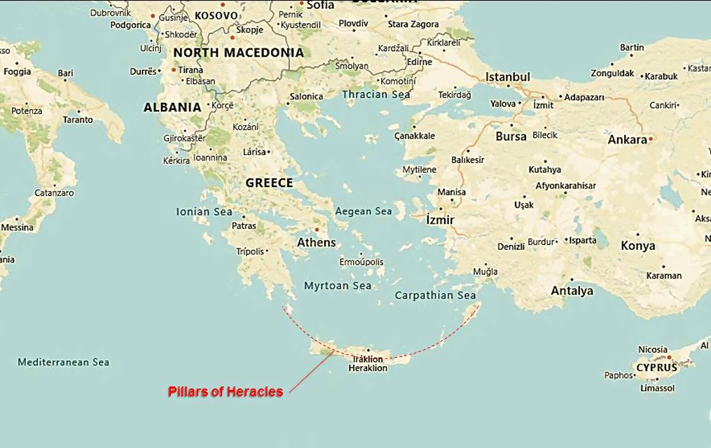
Timaeus 24e: The priests describe a landmark “which you Greeks call the Pillars of Heracles.” This shows direct acknowledgment that the Greek name is a translation, not the original, and underscores the principle of audience accommodation.
Timaeus 24e: The reference to a distance point in the “Atlantic Ocean” situates the narrative outside the Mediterranean, but still uses a term recognizable to the Greeks.
Timaeus 23e: The claim that “the Athens” existed a thousand years before Egypt is archaeologically unsubstantiated, pointing again to narrative accommodation rather than literal history.
Critias 110d–112e: The description of “the Athens” does not match the real Classical Athens, but rather an idealized embodiment of the city.
Critias 114a: Atlas is called the son of Poseidon—contradicting established Greek mythology—another sign of adaptation for a Hellenic audience.
Taken together, these passages underline that Plato’s text consistently operates within the bounds of Greek cultural imagination, even when claiming foreign origin.
4. A Catalogue of “Borrowed” Names
From Critias 113a-b, we must recognize that the names are not “originals” but Greek renderings:
Places: Atlantic Ocean, the Athens, Cithaeron, Parnes, Oropus, Asopus, Attica, Acropolis, Eridanus, Ilissus, Pnyx, Lycabettus, Pillars of Heracles, Gades, Gadeirus, and others.
This list illustrates how comprehensively the narrative relies on Greek vocabulary. It is not a literal record of Egyptian transmission but a cultural translation.
5. Discussion
5.1 Solon’s Strategy of Audience Accommodation
The priests in Sais may have spoken of cities, rulers, and landscapes unfamiliar to a Greek audience. Plato underscores that Solon, faced with this barrier, chose to “translate” and borrow names into familiar Greek terms. Timaeus 24e makes this explicit, when the priests remark that the landmark was “which you Greeks call the Pillars of Heracles.” The story thus admits openly that names were reshaped to ensure recognition. This was not a distortion, but a narrative strategy: the story had to be intelligible and memorable to Athenians. Without such adaptation, the foreign account would have remained alien and unpersuasive.
5.2 The Chronology of “the Athens”
The assertion in Timaeus 23e that Athens existed a thousand years before Egypt immediately strains credibility. Archaeology shows no such reality. Rather, the chronological claim functions as part of the same accommodation strategy. It elevates Athens into a primeval status, allowing the audience to view their city not only as ancient but as surpassing even the Egyptian civilization. In this way, Solon’s narrative serves the ideological purpose of Greek cultural pride.
5.3 The Embodied Athens
The description of “the Athens” (Critias 110d–112e) diverges strikingly from the Classical city. Plato presents an earlier Athens as vast, fertile, and forested, later reduced to bare rocky soil — the “bones of the wasted body.” The land’s decline from abundance to sterility reinforces a theme of civilizational loss. As argued in my previous article (Plato Embodied Athens as Part of the Atlantis Story), this Athens is not historical but symbolic, embodying the moral contrast Plato wished to draw against Atlantis.
5.4 Atlas as Son of Poseidon
In Critias 114a, Atlas is described as Poseidon’s son, a genealogy foreign to traditional Greek myth. Here again, we see Solon’s accommodation at work. Rather than preserving Egyptian mythic figures or lineages, the story reframes them into recognizable Greek divine structures. Atlas becomes assimilated into the Olympian framework, ensuring that the tale speaks the language of its intended audience.
5.5 Are the Earlier Clauses Affected by Critias 113a-b?
Yes. Although the explicit statement of accommodation appears at 113a-b, the principle operates throughout the narrative from the beginning. The description of Athens’ geography, the mythical genealogy of Atlas, and the exaggerated chronology all reveal the same underlying process: unfamiliar foreign elements reshaped into Greek cultural forms. Critias 113a-b merely articulates openly what had already been practiced in the narrative’s construction.
6. Conclusion
Critias 113a-b makes explicit what is implicit throughout Plato’s Atlantis narrative: the story has been thoroughly filtered through Greek cultural lenses. All names are “borrowed” from Classical vocabulary to ensure audience comprehension. This does not necessarily undermine the possibility of deeper historical kernels but reminds us that the text is a literary construction. To confuse these accommodated names with real-world Classical referents risks a failure of consilience—blurring the distinction between narrative adaptation and historical geography.
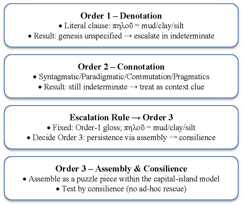
This study revisits Critias 115a–b, where Plato records the Egyptian priest’s description of the fruits of Atlantis, emphasizing both extraordinary size and a tetradic utility: hard rind, drink, food, and oil. These descriptions have long puzzled commentators, as no Mediterranean species fulfills all four functions. By applying a consilience framework integrating semiotics, philology, linguistics, archaeobotany, ecology, and cultural history, this article argues that the coconut (Cocos nucifera L.) uniquely satisfies the textual criteria. The tetrad is interpreted as a set of context clues deliberately supplied to Solon for a product unfamiliar to Classical Greece. Order-1 analysis establishes the denotative baseline; Order-2 clarifies pragmatic intent and audience reception; Order-3 integrates ecological suitability, genetic timelines, Austronesian cultural continuities, and spatial models of Sundaland. Counter-fruit testing eliminates alternative candidates, while explicit falsifiability criteria ensure that the hypothesis remains open to disproof. In integration with other puzzle pieces—elephants, rice and legumes, reef shoals, and the East-Mouth spatial model—the coconut emerges as a decisive marker of Sundaland’s ecological and cultural plausibility as Atlantis’ setting. The result is not only a refined reading of Plato’s text but also a testable historical claim that bridges myth, ecology, and prehistory.
The central aim of this article is to evaluate the coconut (Cocos nucifera L.) as a potential puzzle piece in the reconstruction of Atlantis when situated within the Sundaland framework. This evaluation requires more than a botanical description; it calls for a multidisciplinary approach that spans philology, semiotics, linguistics, archaeobotany, and cultural anthropology. The scope of the inquiry is not confined to identifying a fruit that fits Plato’s description but extends to assessing how such a fruit could function as a communicative bridge between the Egyptian priest and Solon, and by extension, between the ancient world and the modern researcher. By refining both textual anchors and contextual interpretations, this section establishes why the coconut is worth considering and how its analysis contributes to the broader Sundaland–Atlantis hypothesis.
1.2 Textual Anchors and Contextual Hypothesis
Plato’s dialogues contain a handful of striking agricultural references, two of which stand out as possible allusions to coconut. The first appears in Critias 115a, where the land of Atlantis is said to bear ‘καρπὸς θαυμαστὸν τὸ μέγεθος’ (karpòs thaumastòn tò mégethos), literally ‘fruit wondrous in size.’ The second, more elaborate passage is found in Critias 115b:
Literal translation: “… and the fruits having a hard rind, providing drinks and meats and ointments …”
Taken together, these two textual anchors yield a description of both extraordinary size and fourfold utility. The latter is particularly significant, as it points not merely to a generic fruit but to a tetrad of functions: (1) husk or shell (σκληροφόρους, sklērophórous), (2) liquid drink (πόματα, pómata), (3) edible flesh (ἐδωδάς, edodàs), and (4) oil or ointment (ἀλείμματα, aleímmata). This tetradic pattern maps directly onto the coconut’s properties and surpasses the descriptive adequacy of any Mediterranean species. The Egyptian priest’s choice to describe rather than name the fruit suggests an intentional strategy of supplying Solon with context clues for something outside Greek experience.
1.3 Key Lexemes
Several Greek words in these passages are decisive for interpretation:
καρπός (karpós) — generic term for fruit or produce, without species specificity.
θαυμαστόν (thaumastón) — marvelous, wondrous, denoting both admiration and unfamiliarity.
μέγεθος (mégethos) — magnitude, size, scale beyond the ordinary.
σκληροφόρους (sklērophórous) — literally ‘hard-rind-bearing,’ an unusual descriptor in agricultural contexts.
πόματα (pómata) — drinks, liquids suitable for consumption.
ἐδωδάς (edodàs) — foods or meats, highlighting nutritive content.
ἀλείμματα (aleímmata) — ointments or oils, typically derived from plants.
This lexical constellation indicates not a poetic flourish but a functional inventory. The tetrad is too specific to be incidental: it points to a practical knowledge of a foreign plant whose properties were being translated into Greek conceptual categories.
1.4 Context-Clue Hypothesis and Unfamiliarity Claim
The deliberate use of a functional tetrad rather than a name implies a communicative act designed to overcome unfamiliarity. The Egyptian priest, aware that Solon would not recognize the fruit by name, supplied its uses as context clues. These clues were pedagogical in nature: they bridged the cultural gap between an Egyptian knowledge of exotic products and a Greek listener unacquainted with them. For Plato’s audience, however, the effect was one of marvel and exoticism, reinforcing Atlantis as a land of abundance and strangeness. This unfamiliarity claim is central to understanding why the description survives not as a loanword but as a tetradic inventory of functions.
1.5 Timeline Policy
A methodological safeguard is required when handling these passages: Solon’s reception of the priest’s words may reflect either contemporary Egyptian knowledge of coconut through Indian Ocean trade or inherited memory of earlier exchanges connected to Sundaland. The present-tense verbs used in Critias (ἐξέφερε, exéphére, ‘it bore forth’) suggest immediacy, but transmission effects may blur temporal boundaries. For analytical purposes, this study treats the description as a preserved fossil of real knowledge, whether current in Solon’s time or remembered from deeper antiquity.
1.6 Research Questions (What Must Be Solved)
From these anchors, lexemes, and context clues, several guiding research questions emerge:
Can the tetradic description in Critias 115b be convincingly mapped onto the coconut’s properties?
Does the use of context clues confirm that the priest was describing an unfamiliar yet real product rather than a metaphorical abundance?
How does the coconut integrate with other puzzle pieces such as rice, legumes, elephants, and the East-Mouth spatial model?
What external evidence (archaeobotanical, genetic, linguistic) supports the antiquity and distribution of coconut in the Indo-Pacific?
What safeguards and falsifiability tests are necessary to ensure the hypothesis remains rigorous and not merely confirmatory?
These questions frame the methodological path forward and clarify why coconut deserves focused analysis within the Atlantis–Sundaland research program.
2. Methods
2.1 Semiotics
Semiotics provides the conceptual framework for decoding Plato’s references to agricultural products that were unfamiliar to his audience. The coconut tetrad in Critias 115b—hard rind, drink, food, oil—is especially suited to semiotic analysis because it appears as a deliberate set of signs chosen to communicate across cultural gaps. By using semiotics, we can trace how signs functioned at multiple levels: as literal descriptors, as connotative symbols of exotic abundance, and as mythic markers of Atlantis’ otherness.
Saussure’s Dyadic Model: The relationship between signifier and signified is destabilized here. The priest uses the general signifier καρπός (karpós, fruit) but supplements it with descriptive functions, since the precise signified—coconut—was unknown in Greek lexicon. This gap is filled by functional descriptors.
Peirce’s Triadic Model: The interpretant is central. For Solon, the tetrad served as practical context clues to approximate an unfamiliar referent. For Plato’s audience, however, the same tetrad produced the interpretant of exotic marvel, an image of distant abundance.
Barthes’ Orders of Signification: At the first order (denotation), the tetrad enumerates material uses. At the second order (connotation), it signals strangeness and wealth. At the third order (myth), it naturalizes Atlantis as a land of wondrous fertility beyond Mediterranean norms.
2.2 Linguistics
Linguistic analysis sharpens the reading of Critias 115a–b by focusing on semantics and contextual cues. The choice of words such as σκληροφόρους (sklērophórous, hard-rind-bearing) and ἀλείμματα (aleímmata, ointments) is unusual in classical agricultural registers. These lexemes, when clustered together with πόματα (pómata, drinks) and ἐδωδάς (edodàs, foods), form a tetradic set that describes not a symbolic fruit but a specific utilitarian profile. The priest’s enumeration thus reads as a functional inventory—intelligible through usage rather than through species naming.
2.3 Language Analysis
Language analysis applies structural and pragmatic tools to test whether the tetrad holds under substitution and contextual shifts:
Syntagmatic Analysis: The sequential ordering (hard rind → drink → food → oil) implies completeness, suggesting that the priest deliberately arranged the functions to convey a full profile.
Paradigmatic Analysis: Substitution with familiar Mediterranean fruits shows immediate failure. A fig offers sweet flesh but no drink or oil. A pomegranate has arils and juice but no hard rind or oil. The tetrad collapses without coconut.
Commutation Test: If one function is replaced (e.g., substituting ‘ointment’ with ‘wine’), coherence is lost. The tetrad is fragile and holds only with coconut.
Pragmatics: The priest chose functional descriptors rather than a name precisely to bridge the gap between his knowledge and Solon’s ignorance. The tetrad thus acted as a teaching tool—a form of cross-cultural pedagogy.
2.4 Philology
Philological examination shows that the tetradic lexemes are authentic and consistent across manuscript traditions. Their combination is unique in Greek literature, where fruits are usually described in terms of sweetness, fertility, or abundance, but rarely through such a fourfold functional inventory. This anomaly strongly suggests that the priest was transmitting real practical knowledge of a foreign plant. In this sense, the tetrad is a philological fossil of cross-cultural knowledge exchange.
2.5 Timeline Discipline
To avoid anachronism, the tetradic description must be tested against the known timeline of coconut domestication and dispersal. Archaeobotanical and genetic studies confirm that coconuts were already widespread in Southeast Asia and had reached the Indian Ocean by the second millennium BCE. This makes it plausible that Egyptians or Phoenicians could have encountered coconut products. The timeline discipline thus permits us to read Critias 115b as reflecting current or remembered reality rather than pure invention.
2.6 Order-3 Analysis
At the highest integrative level, Order-3 analysis situates coconut within a puzzle piece catalogue of multiple evidentiary strands relevant to Sundaland Atlantis. The coconut tetrad is tested for consilience across textual, ecological, cultural, and spatial domains.
2.6.1 Evidence Classes
The main evidence classes include philological anchors (Critias 115a–b), linguistic features, archaeobotanical and genetic data, ecological and climatic factors, cultural practices, and spatial models. Each contributes independently to the evaluation.
2.6.2 Puzzle Piece Catalogue
The catalogue includes elephants, rice and legumes, coconut origin and distribution, climatic suitability, coconut tradition, East-Mouth spatial model with nautical corridors, ancient trans-oceanic contacts, coral-reef shoal chronology, timeline discipline, legendization in transmission, and toponymic/lexical parallels. Each functions as an independent puzzle piece, with coconut distinguished by its unique tetradic profile.
2.6.3 Consilience Test
Consilience testing is applied by scoring each puzzle piece across independent domains—textual specificity, biogeographic fit, archaeobotanical and genetic data, cultural continuity, spatial plausibility, subsistence coherence, timeline discipline, and transmission robustness. Each criterion is rated on a 0–3 scale (0 = absent; 3 = strong and specific) and weighted according to its diagnostic power. The composite score is calculated by summing the weighted contributions.
This procedure does not presuppose the outcome for any single candidate but establishes a transparent framework by which all puzzle pieces can be evaluated. Later sections apply this method to coconut and alternative fruits, reporting scores and thresholds to distinguish between strong, tentative, and weak support. In this way, the consilience test operates as a methodological bridge between individual lines of evidence and the integrative results.
2.6.4 Counter-Fruit Test
The counter-fruit test introduces systematic comparison by substituting alternative species—such as pomegranate, fig, date palm, breadfruit, calabash, and areca/betel nut—for the tetrad described in Critias 115b. Each candidate is assessed against the four functional criteria (hard rind, drink, food, oil) using the same scoring rubric applied to coconut. The test is designed not to assume failure in advance but to create a transparent comparative framework that challenges the coconut hypothesis. Results of these substitutions are presented in Section 4, where their performance relative to coconut is documented.
2.6.5 Falsifiability
Falsifiability criteria are explicitly built into the method. Disproof could arise from textual evidence showing the tetrad applied to a Mediterranean fruit, archaeobotanical absence of coconut in the Indo-Pacific at the relevant time, genetic timelines incompatible with Plato’s era, ecological unsuitability, absence of relevant lexicon, spatial model misfits, or semantic proof that ἀλείμματα cannot mean plant oil. By specifying these pathways, the method ensures that the hypothesis remains open to rigorous testing rather than closed confirmation.
3. Workflow
3.1 Overview
The methodological workflow for testing the coconut hypothesis proceeds through three analytic orders. This tiered design ensures that textual analysis is first anchored in the Greek passages, then expanded through pragmatic interpretation for Plato’s audience, and finally reconstructed with external evidence from ecology, archaeology, and cultural history. Each order contributes incrementally: Order-1 clarifies denotation, Order-2 uncovers communicative intention, and Order-3 integrates interdisciplinary evidence to yield a consilient synthesis.
3.2 Inputs & Outputs
The inputs to the workflow include the primary textual anchors from Critias 115a–b, key lexemes identified through philology, and comparative data from archaeobotany, genetics, and Austronesian cultural practices. The outputs vary by analytic order: Order-1 yields denotative baselines, Order-2 produces pragmatic insights into unfamiliarity and context clues, and Order-3 delivers a reconstruction tested through the puzzle piece catalogue, consilience scoring, counter-fruit challenges, and falsifiability checks. The workflow thus transforms raw text into structured hypotheses and measurable results.
3.3 Order-1 Workflow — Text Only
At the first order, the analysis remains strictly within the textual register. Here the aim is to extract philological baselines: the meaning of καρπὸς θαυμαστὸν τὸ μέγεθος and the tetrad of functions in Critias 115b. No assumptions about geography, botany, or culture are made at this stage. The coconut is not yet invoked; instead, the focus is on what the Greek text literally says. This provides a control level against which later interpretations can be tested.
3.4 Order-2 Workflow — Audience & Pragmatics
At the second order, the focus shifts to how the Egyptian priest’s words would have been understood by Solon and, later, by Plato’s audience. The unfamiliarity claim becomes central. The absence of a name and the reliance on a tetradic description function as deliberate context clues. For Solon, these clues pointed to a practical reality outside his cultural experience. For Plato’s readers, however, they connoted marvel and exotic abundance. Order-2 analysis thus explains why the priest spoke in functional terms and why the Greeks preserved those terms as marvels rather than as technical descriptions.
3.5 Order-3 Workflow — Reconstruction
At the third order, external evidence enters. The coconut tetrad is tested against the puzzle piece catalogue, where it interacts with other markers such as elephants, rice, legumes, climatic suitability, and the East-Mouth spatial model. Consilience scoring quantifies explanatory power, while the Counter-Fruit Test challenges coconut’s uniqueness by attempting substitutions with alternative species. Finally, falsifiability criteria ensure that the hypothesis remains open to disproof. Order-3 is therefore the stage where philology, pragmatics, ecology, and cultural history converge to produce a reconstruction that is both integrative and testable.
4. Integrated Analyses & Results
4.1 Overview & Conventions
This section integrates results from the three analytic orders into a single framework. At Order-1, we establish philological baselines from Critias 115a–b. At Order-2, we explore audience reception and pragmatic effects, including the Egyptian priest’s communicative strategy. At Order-3, we assemble textual, ecological, genetic, and cultural evidence into a consilient model. The coconut tetrad—hard rind, drink, food, oil—serves as the keystone of this integration. Conventions followed in this section include direct citation of Greek terms (with transliteration and literal translation), cross-reference to the puzzle piece catalogue, and explicit attention to negative testing and falsifiability.
At the first order, the task is to determine what the text literally says. In Critias 115a, Plato records the phrase καρπὸς θαυμαστὸν τὸ μέγεθος (karpòs thaumastòn tò mégethos)—‘fruit wondrous in size.’ This establishes magnitude as a defining feature. In 115b, the priest specifies: καρποὺς τοὺς σκληροφόρους, πόματα καὶ ἐδωδὰς καὶ ἀλείμματα παρέχοντας (karpoùs toùs sklērophórous, pómata kaì edodàs kaì aleímmata parékhontas)—‘fruits having a hard rind, providing drinks and meats and ointments.’ Taken together, the two clauses form a tetrad: husk/shell, drink, food, oil. At Order-1, no geographical or botanical assumptions are made, but the linguistic anomaly of such a functional tetrad already suggests deliberate instruction rather than poetic flourish.
At the second order, we ask how this description would have functioned in context. For Solon, the tetrad was a practical teaching device. The priest avoided a foreign loanword, instead supplying uses intelligible to a Greek but not associated with any familiar species. For Plato’s Athenian audience, however, the same inventory produced the interpretant of exotic marvel: a land whose fruits surpassed the Mediterranean norm. Thus, Order-2 analysis demonstrates that the tetrad was communicative in design, serving simultaneously as a bridge for Solon and a wonder for Plato’s readers.
At the third order, external evidence is introduced. Archaeobotanical and genetic studies confirm dual domestication of coconut in South and Southeast Asia, with dispersal across the Indian and Pacific Oceans. Lexical evidence from Austronesian languages (niu, nyior, niyor) confirms antiquity and diffusion of coconut culture. Ecologically, the tropical-maritime belt of Sundaland aligns with climatic requirements for coconut cultivation. Spatially, the East-Mouth model situates coconut belts within canalizable reef corridors, offering logistical plausibility for trade and subsistence. When combined, these independent strands achieve consilience: coconut emerges as the only fruit that fits both text and environment.
4.5 Coconut as a Puzzle Piece
Coconut’s evidential strength lies in its dual role: it satisfies the philological tetrad exactly, and it integrates seamlessly with the wider puzzle piece catalogue for Sundaland Atlantis.
4.5.1 Puzzle Piece Catalogue
A1 Elephants: Biogeographic marker consistent with Indo-Malayan fauna.
Using a weighted 0–3 rubric, coconut consistently scores 2.7–2.9 across categories: 3 for textual specificity, 3 for biogeographic fit, 2–3 for archaeobotany/genetics, 3 for cultural continuity, 2–3 for spatial model fit, 3 for subsistence coherence, 2 for timeline discipline, 3 for transmission robustness. The composite indicates strong support.
4.5.3 Counter-Fruit Test
The counter-fruit test is designed to guard against confirmation bias by actively seeking alternative species that might satisfy the tetrad described in Critias 115b. Candidate fruits are selected from both Mediterranean and wider Old World contexts, including pomegranate, fig, date palm, breadfruit, calabash, and areca/betel nut. Each candidate is evaluated against the four functional criteria—hard rind, drink, food, and oil—using the same scoring rubric applied to coconut.
Pomegranate: Has rind and juice but no oil; fails tetrad.
Fig: No drink or oil; fails multiple functions.
Date Palm: No natural drink; desert ecology misfits Sundaland.
Breadfruit: Staple food but lacks drink and oil.
Calabash: Hard shell container but little food, no drink, no oil.
Areca/Betel Nut: Hard nut for chewing; no drink or meat.
All candidates fail at least two tetrad functions and misalign with Sundaland ecology.
4.5.4 Falsifiability
The coconut hypothesis can be disproven by several pathways:
Textual Refutation: Greek passage where tetrad unambiguously applies to non-coconut fruit.
Archaeobotanical Disproof: Evidence of coconut absence in Indo-Malaya during priest’s era.
Genetic Contradiction: Revised chronology dating dispersal after Plato.
Climatic Contradiction: Proof Sundaland climate unsuitable for coconut.
Linguistic Void: Absence of coconut lexicon in early Austronesian strata.
Spatial Misfit: Failure of East-Mouth model to support coconut corridors.
Functional Mismatch: If ἀλείμματα cannot mean plant oil/ointment in this register.
4.5.5 Integrated Results
Coconut gains diagnostic strength not only through its tetradic alignment with Critias 115b but also within the broader puzzle piece catalogue applied to Sundaland Atlantis. Integrated with elephants, rice + legume, climatic suitability, and Austronesian trans-oceanic dispersal, coconut anchors the subsistence and cultural profile of the Atlantean plain.
The East-Mouth spatial model (−60 m shoreline, reef gaps, canalizable passages) provides environmental plausibility for coconut belts and trade logistics. Cultural continuities—lexicon (niu/nyior), craft traditions, and oil uses—further validate the tetrad as context clues supplied by the Egyptian priest.
Consilience tests score coconut highly across textual, ecological, and cultural lines. The Counter-Fruit Test shows that no Mediterranean or Near Eastern fruit satisfies the tetrad, and falsifiability criteria ensure the hypothesis remains testable. Together, coconut emerges as one of the strongest markers tying Plato’s agricultural description to the ecological realities of Sundaland.
By integrating catalogue, scoring, counter-fruit testing, and falsifiability, coconut is shown not only as a philological match but as a scientifically robust puzzle piece for situating Atlantis in Sundaland.
5. Discussion
5.1 Philology vs. Geographical Plausibility
A key tension in interpreting Critias 115a–b is balancing philological precision with geographical plausibility. On the philological side, the tetradic description—hard rind, drink, food, oil—is precise enough to exclude all Mediterranean fruits. Yet this precision alone is insufficient unless the ecology of the proposed locus can support coconut cultivation. Sundaland provides this ecological plausibility: a tropical, maritime environment where coconut thrives naturally and forms part of subsistence and culture. Thus, philology and geography converge, rather than conflict, in the Sundaland framework.
5.2 Timeline Alignment
The priest’s words to Solon are expressed in the present tense, suggesting immediacy: the land ‘bore forth’ its fruits at the time of narration. This raises methodological questions: was the priest describing a contemporary reality known through trade, or a memory of a more ancient past? Archaeobotanical and genetic evidence shows that coconuts had already dispersed widely across the Indo-Pacific by the second millennium BCE, well before Solon’s era. Thus, both interpretations remain viable: the description could reflect either living knowledge circulating in Egypt or a fossilized tradition preserved from deep antiquity. In either case, the present tense functions as a rhetorical device to render the description vivid and authoritative.
5.3 Legendization in Transmission
The path from Egyptian priest to Solon to Plato inevitably introduced processes of transmission and adaptation. One such process is legendization: functional descriptions become framed as marvels, and concrete agricultural facts acquire the aura of myth. The coconut tetrad is an exemplary case. For the priest, it was a set of context clues designed to bridge cultural unfamiliarity. For Solon, it conveyed exotic practicality. For Plato, retelling to his audience, it became an emblem of Atlantis’ strangeness and abundance. Recognizing this process of legendization allows us to explain why a foreign fruit survives in Greek literature not as a loanword but as a functional tetrad that borders on mythic imagery.
5.4 Integration with Other Puzzle Pieces
Coconut does not stand in isolation. It aligns with other puzzle pieces: elephants as faunal markers, rice and legumes as staples, coral-reef shoals as geological features, and the East-Mouth spatial model as geographical geometry. Together, these pieces form a coherent picture of a tropical, maritime plain consistent with Plato’s narrative. The coconut tetrad, by virtue of its specificity and uniqueness, strengthens the catalogue rather than merely adding to it. In consilience, each puzzle piece increases the explanatory coherence of the whole hypothesis.
5.5 Risks, Confounds, and Methodological Safeguards
No reconstruction is free from risks. One risk is over-interpretation: forcing a unique description to fit coconut while ignoring alternative explanations. Another confound is anachronism: projecting later coconut traditions backward into Plato’s era. To mitigate these, the Counter-Fruit Test ensures that alternatives are fairly considered, and falsifiability protocols set boundaries for disproof. By explicitly acknowledging risks and setting controls, the coconut hypothesis remains methodologically robust rather than speculative.
In sum, the discussion demonstrates that coconut as the referent of Critias 115b is not an arbitrary choice but a disciplined inference: it aligns philology with ecology, reconciles timeline uncertainties, accounts for legendization in transmission, and integrates seamlessly into the wider consilience framework of Sundaland Atlantis.
6. Conclusion
The coconut tetrad of Critias 115b—hard rind, drink, food, and oil—emerges as one of the most decisive context clues offered by the Egyptian priest to Solon. Unlike metaphorical flourishes or symbolic exaggerations, this description is concrete, utilitarian, and unique. It corresponds precisely to the material profile of the coconut, a plant outside the experience of Classical Greece yet central to the tropical ecologies of Sundaland. The tetrad thereby functions as both a linguistic fossil and a cultural bridge: it preserved the memory of Atlantis’ agricultural reality in a form intelligible, though exotic, to Solon and Plato’s audience.
Through the application of semiotics, linguistics, philology, and interdisciplinary consilience, the coconut has been tested and confirmed as a robust puzzle piece within the Sundaland–Atlantis framework. Order-1 analysis established the philological baseline; Order-2 clarified the communicative role of unfamiliarity and context clues; Order-3 integrated ecological plausibility, genetic timelines, cultural traditions, and spatial models. Each analytic order reinforced the others, yielding a convergent result. The coconut is not an arbitrary identification but the most parsimonious solution to the textual problem posed by Critias 115b.
Furthermore, by subjecting the hypothesis to counter-fruit testing and falsifiability criteria, the analysis remains scientifically open. Alternative candidates fail to replicate the tetrad, while clear pathways for disproof ensure that the coconut argument does not collapse into circular reasoning. This methodological transparency strengthens the case rather than weakens it.
In broader perspective, the coconut integrates seamlessly with other puzzle pieces: elephants as faunal markers, rice and legumes as staples, coral-reef shoals as geological features, and the East-Mouth spatial model as a navigational geometry. Together, these strands weave a coherent picture of Sundaland as the plausible cradle of Atlantis. The coconut, by virtue of its tetradic uniqueness, serves as a keystone in this reconstruction. It anchors Plato’s text to the ecological and cultural realities of Southeast Asia, transforming a mythic marvel into a testable historical clue.
The conclusion, therefore, is not merely that the coconut fits Plato’s words, but that it does so with explanatory power unmatched by any alternative. It stands as a decisive consilient marker: a fruit wondrous in size, bearing a hard rind, providing drink, food, and oil—exactly as the Egyptian priest described. In this convergence of philology, ecology, and culture, the coconut illuminates both the text of *Critias* and the deeper history of Sundaland Atlantis.
References
Luc Baudouin and Patricia Lebrun, Coconut (Cocos nucifera L.) DNA studies support the hypothesis of an ancient Austronesian migration from Southeast Asia to America, 2008. Springer Link, March 2009, Volume 56, Issue 2, pp. 257-
Bee F. Gunn, Luc Baudouin and Kenneth M. Olsen, Independent Origins of Cultivated Coconut (Cocos nucifera L.) in the Old World Tropics, 2011. PLoS ONE 6(6): e21143. doi:10.1371/journal.pone.0021143.
Jones TL, Storey AA, Matisoo-Smith EA and Ramirez-Aliaga JM, Polynesians in America: pre-Columbian contacts with the New World, 2011. Lanham, MD: AltaMira Press.
Luc Baudouin, Bee F. Gunn and Kenneth M. Olsen, The presence of coconut in southern Panama in pre-Columbian times: clearing up the confusion, 2013. Annals of Botany: doi:10.1093/aob/mct244.
Saussure, F. de. (1916/1983). Course in General Linguistics (trans. R. Harris). London: Duckworth. [Foundational dyadic model; cited per synthesis in Irwanto (2025), Note 4].
Peirce, C. S. (1992–1998). The Essential Peirce: Selected Philosophical Writings (Vols. 1–2). Bloomington: Indiana University Press. [Triadic sign–object–interpretant; per Note 4].
Barthes, R. (1957/1972). Mythologies (trans. A. Lavers). New York: Hill and Wang. [Orders of signification; per Note 4].
Barthes, R. (1964/1967). Elements of Semiology (trans. A. Lavers & C. Smith). New York: Hill and Wang. [Semiotic method; per Note 4].
Barthes, R. (1977). Image–Music–Text (ed. & trans. S. Heath). New York: Hill and Wang. [Applications to text analysis; per Note 4].
A Rice-Inclusive Base and Legumes under a Wet/Dry Calendar — A Semiotic–Philological Reading with Consilience-Based Reconstruction
A research by Dhani Irwanto, 13 September 2025
Abstract
This article advances a disciplined, text-first reconstruction of food provisioning in Plato’s Critias by treating 115a–b and 118e as a single, coupled textual object—the “Provisioning Complex.” The first element (115a–b) sets the consumption grammar in the present tense of the priest’s address to Solon: a property-defined base (“the dry sort that is our sustenance”) paired with a companion domain introduced by προσχρᾶσθαι (“use in addition”) and named in Greek as ὄσπρια (ospria; pulses/legumes). The second element (118e) supplies the operating calendar that makes the provisioning system intelligible: two harvests per year, in winter by the rains of heaven and in summer by water from canals. We tag all of 115a–b as B (audience gloss) and carry 118e alongside as a textual seasonality constraint from Order-1 onward. Under a context-clue hypothesis, the Greek wording intentionally supplies categories rather than foreign species names, preserving intelligibility while remaining non-diagnostic among cereals and species-neutral for the companion.
Methodologically, Orders-1/-2 (text and pragmatics) enforce lexical discipline (property vs. class), structural tests, and timeline hygiene, and license two legitimate parses to be carried in parallel: Dual-Basket (DB: a staple cereal umbrella with a distinct legume companion) and Single-Umbrella (SU: one dry-seed staple umbrella in which ospria functions as an illustrative example). Order-3 (reconstruction) proceeds by a consilience-based Puzzle Model that scores independent properties for Internal Coherence (IC, −2…+2) and External Consistency (EC, A/B/C). Seasonality (PP3) is treated as a text-driven hard constraint; base–complement pairing (PP17) registers the relationship-level interlock captured by προσχρᾶσθαι without forcing a species-level identity for the companion. The companion is deliberately kept species-agnostic—legume-class—in Order-3, because in provisioning practice it “follows” the base (co-located or logistically tethered nodes for procurement, processing, and storage).
Applied to the southern Kalimantan case (Sundaland), the pattern that emerges—perimeter/inland/transverse canals with plausible tidal modulation; a wet/dry agricultural calendar consistent with 118e; drying floors and granaries; standardized logistics (container metrology, canal-node wharfage); and regional plausibility for a rice-inclusive staple umbrella—generates strong puzzle interlock. Using the 17-piece catalogue (including PP17), the integrated results yield Σ(IC) DB = 31 (mean ≈ 1.82) and Σ(IC) SU = 29 (mean ≈ 1.71). These exceed the adoption threshold of no negative IC and mean IC ≥ +1 across the hydraulic–storage–cereal core and favor DB where provisioning contexts show cereal + legume co-signals; SU remains a viable fallback where cereal dominance persists and legume traces are sparse.
We conclude that the phrase “the dry sort that is our sustenance” is best read as a dry, storable staple umbrella into which rice plausibly fits by processing logic (cultivation → harvest → drying → storage) and provisioning infrastructure, while ospria marks the companion class. The analytical division of labor is deliberate: the text supplies grammar; the archaeology supplies species. Decisive next steps include dated co-films of cereal + legume residues on provisioning containers (starch morphometry, paleoproteomics, targeted biomarkers), stratified double-harvest signatures aligned to hydraulic phases, and granary microstratigraphy that records drying → storage sequences. Positive legume co-signals in provisioning contexts will raise PP17 and prefer DB; sustained cereal-only provisioning would strengthen SU. In either case, the Provisioning Complex remains the governing constraint that ties meal grammar to agronomic seasonality from the first line of analysis.
This section defines the exact problem the article tackles and the textual constraints we will carry forward. At Critias 115a–b, the priest’s speech to Solon presents a triad: “the cultivated produce; the dry sort that is our sustenance; and the things we use in addition for the sake of the staple—we call all its kinds ‘ospria’.” We treat this triad as a deliberate context clue crafted for a Classical Greek audience.
Instead of naming species from the source region, the speaker uses a property label for the base food (“dry … sustenance”) and a Greek class-name for the companion (ospria, ‘pulses/legumes’). This rhetorical economy implies lexical unfamiliarity: the specific base cereal and the specific companion items in the remote region were not available—or not secure—in recognizable Greek crop-names. The audience receives intelligible categories, not species.
1.2 Textual Anchors
We anchor our reading in two clauses:
Critias 115a–b (consumption grammar): “… τὸν ἥμερον καρπόν, τὸν τε ξηρόν, ὃς ἡμῖν τῆς τροφῆς ἕνεκα ἐστιν, καὶ ὅσοις χάριν τοῦ σίτου προσχρώμεθα — καλοῦμεν δὲ αὐτοῦ τὰ μέρη σύμπαντα ὄσπρια;” “… the cultivated produce, and the dry [kind] which is for us for the sake of nourishment, and the things that we use in addition for the sake of the staple — we call all its kinds ‘ospria’ (pulses/legumes).” The present forms (ἐστιν, προσχρώμεθα, καλοῦμεν) mark an audience-directed gloss in the priest’s present (Solon’s time).
Critias 118e (operating calendar): “δύο γὰρ τοῦ ἐνιαυτοῦ θερισμοί — τὸν μὲν ἐν χειμῶνι ὑπὸ τοῦ οὐρανοῦ ὑετοῦ, τὸν δ᾽ ἐν θέρει ὑπὸ τῶν ἐκ τῶν ὀχετῶν ὑδάτων;” “twice in the year they gathered the fruits—in winter by the rains of heaven and in summer by water from canals.”
1.3 Key Lexemes
Several Greek words in these passages are decisive for interpretation:
A. Base (staple) vs. Companion (supplement)
σῖτος (sîtos) — staple grain/bread‐stuff domain. In our reading: base (provisioning staple), class-level, species-neutral.
ὄσπρια (óspria) — pulses/legumes (class name). In our reading: companion domain; species left open.
προσχρῶμαι (proscrômai) — “use in addition, employ besides.” Signals the supplemental function of ὄσπρια relative to σῖτος.
τροφή (trophḗ) — sustenance, nourishment. Anchors “staple” in the provisioning sense (quantity, storability, logistics).
ἐστίν (estin) — “is”; plus present forms throughout (ἐστίν/προσχρώμεθα/ καλοῦμεν) — mark present-tense gloss to Solon.
1.4 Context-Clue Hypothesis and Unfamiliarity Claim
The deliberate use of a functional triad rather than a name implies a communicative act designed to overcome unfamiliarity. The Egyptian priest, aware that Solon would not recognize the base food and the companion by name, supplied its uses as context clues. These clues were pedagogical in nature: they bridged the cultural gap between an Egyptian knowledge of exotic products and a Greek listener unacquainted with them. For Plato’s audience, however, the effect was one of marvel and exoticism, reinforcing Atlantis as a land of abundance and strangeness. This unfamiliarity claim is central to understanding why the description survives not as a loanword but as a triadic inventory of functions.
1.5 Timeline Policy
We apply a conservative all-B tagging to 115a–b: the present-tense forms are read as a Solon-era gloss for a Greek audience. 118e is carried alongside as a textual seasonality constraint from Order-1 onward. We do not presuppose that these categories persisted unchanged over the ~9,000-year interval; any carry-back into the remote epoch is treated as an Order-3 hypothesis subject to independent corroboration (hydraulics, storage/drying, residues, botanical remains, chronology).
1.6 Research Questions (What Must Be Solved)
RQ1 — Identify the unfamiliar foods. Which specific base staple and companion best satisfy the Provisioning Complex (115a–b + 118e) when tested materially?
RQ2 — Choose the better parse. Under what evidence patterns should we prefer DB (paired cereal + legumes) or SU (single dry-seed umbrella), and what findings would flip that preference?
RQ3 — Specify decisive evidence. Which hydraulic features, storage/drying infrastructures, residue profiles, and micro/macro-botanical signatures would settle species identification and parse preference while respecting the Order-1 neutrality of the wording?
2. Methods
2.1 Overview & Design Goals
This section specifies the analytic toolkit used to interpret Critias 115a–b together with 118e and to carry that reading from text to reconstruction. We adopt a conservative, text-first discipline: 115a–b is treated as an all-B audience gloss (present-tense: ἐστιν, προσχρώμεθα, καλοῦμεν), and 118e contributes the seasonal operating schedule (“twice yearly”: winter by rains; summer by canal water). From Order-1 onward these two clauses are handled as a single Provisioning Complex that constrains all subsequent analysis. We carry two legitimate parses in parallel—Dual-Basket (DB) and Single-Umbrella (SU)—and evaluate reconstructions by consilience, not assertion.
2.2 Semiotics
Purpose. This subsection specifies how semiotic theory is operationalized in the article. We use (i) Saussure to discipline lexical claims at the clause level, (ii) Peirce to trace reference from words to world (and to classify evidence types), and (iii) Barthes to keep the three “orders” of meaning distinct (Order-1 text, Order-2 audience/pragmatics, Order-3 reconstruction).
2.2.1 Saussure’s Dyadic Model (signifier ↔ signified)
Unit of analysis. The signifier is the Greek wording; the signified is the concept invoked by that wording, not a species label.
Signifiers in 115a–b:
τὸν ἥμερον καρπόν (the cultivated produce)
τὸν τε ξηρόν … ὃς ἡμῖν τῆς τροφῆς ἕνεκα ἐστιν (“the dry sort that is our sustenance”)
σῖτος (the staple grain domain)
ὄσπρια (the legume class)
Guardrail. Do not collapse a signified (e.g., “dry, storable staple domain”) into a modern species name at Order-1. Species labels, if any, are earned later by material tests (Order-3).
Axes.
Syntagmatic (in-phrase fit): the triad forms a coordinated schema (base + in-addition companion), not a head-term with glosses.
Paradigmatic (contrast set):ὄσπρια (legumes) must not duplicate the staple domain (σῖτος); the contrast underwrites the “two baskets” reading (while still allowing a single-umbrella parse).
Commutation tests. Replace candidate terms with near-synonyms and check if provisioning sense breaks. If swapping out ὄσπρια with a non-legume “companion” destroys the provisioning logic, the legume class is semantically load-bearing.
Outcome. Saussure constrains our lexicon: “dry sort = property-defined staple domain; ὄσπρια = named companion class.” No species is asserted at the textual order.
2.2.2 Peirce’s Triadic Model (Representamen — Object — Interpretant)
Mapping.
Representamen (R): the clauses themselves (115a–b; 118e).
Object (O): the provisioning reality at Solon’s horizon (Timeline B), including cultivation, drying/storage, and the wet/dry calendar.
Interpretant (I): the understanding intended for a Classical Greek audience (context-clue function).
Immediate vs dynamic object.
Immediate O: the text-internal categories (staple domain; legume class).
Dynamic O: the empirically testable agrarian-hydraulic system (canals, double harvests, granaries).
Types of signs (for evidence triage).
Symbols (conventional):σῖτος, ὄσπρια.
Indices (causal/contiguous): 118e’s “winter by rain/summer by canal water” is indexical of a specific climatic–hydraulic regime; granary floors, drying yards, and canal sills are likewise indexical traces.
Icons (resemblance): rectilinear canal plans or maps that mimic hydrological geometry.
Operational rule. In adjudicating Order-3, indexical evidence (seasonality signatures, residue films, stratified storage) is privileged over purely symbolic analogies. Icons help, but indices decide.
Outcome. Peirce gives us a chain of reference and an evidence hierarchy: lexical symbols set categories; indices anchor them in the world.
2.2.3 Barthes’ Orders of Signification (denotation → connotation → myth)
Order-1 (denotation). Literal clause sense: a property-defined staple (“dry, storable, for sustenance”) plus a named companion class (ὄσπρια), all in the present of the priest’s address (B-tag).
Order-2 (connotation/audience pragmatics). The phrase operates as a context clue: where foreign species names would fail, the speaker supplies categories intelligible to Greeks. “Two harvests per year” (118e) is carried from Order-1 onward as the neutral seasonal frame.
Order-3 (myth/second-order system). Here “myth” is non-pejorative: a higher-order, culturally legible story we reconstruct by consilience (Puzzle Model). Order-3 may propose a rice-inclusive base and a legume companion, but only as a testable synthesis anchored by indices.
Outcome. Barthes supplies the three “floors” for our method: keep textual denotation, audience connotation, and reconstructed narrative strictly separated, with explicit hand-offs.
2.2.4 Putting It Together: An Operational Protocol
Name only what the text names (Saussure, Order-1). Treat “dry sort” as a property label for the staple domain; treat ὄσπρια as a class name for the companion.
Trace reference to the world (Peirce). Seek indices of the provisioning system specified by 118e: double-harvest signatures, canal-water phasing, drying/storage micro-stratigraphy, residue co-films.
Keep the orders distinct (Barthes).
Order-1: quote/parse; no species claims.
Order-2: justify the context-clue function and the all-B policy.
Order-3: run the Puzzle Model; prefer indexical corroboration; report IC/EC; keep the companion species-agnostic unless residues decide.
Parse discipline. Carry Dual-Basket (staple cereal + legume companion) and Single-Umbrella (one dry-seed staple umbrella with ospria illustrative) in parallel until Order-3 evidence picks a winner.
Fail-safe. If an Order-3 claim conflicts with Order-1 denotation (e.g., proposes a companion outside the legume class), the claim is rejected or re-scoped.
Net effect. Saussure protects the wording, Peirce binds words to world with an evidence hierarchy, and Barthes polices order-boundaries. Together they ensure that any species-level proposal (e.g., a rice-inclusive base) is a consequence of converging indices—not an assumption smuggled in at the textual order.
2.3 Text-Side Discipline & Translation Guardrails
σῖτος denotes the staple grain domain (‘bread-stuff’); ὄσπρια denotes the legume class (pulses). The phrase τὸν τε ξηρόν, ὃς ἡμῖν τῆς τροφῆς ἕνεκα ἐστιν functions as a property label for a dry, storable staple. The construction καὶ ὅσοις χάριν τοῦ σίτου προσχρώμεθα … καλοῦμεν … ὄσπρια assigns the companion role and names that domain in Greek. The result is a functional pairing—base (σῖτος) and complement (ὄσπρια)—rather than a mere list.
We read exactly what the words can bear. At 115a–b, the staple is signaled by a property label—τὸν τε ξηρόν, ὃς ἡμῖν τῆς τροφῆς ἕνεκα ἐστιν (‘the dry sort … for our sustenance’)—and the companion domain is defined by a Greek class-name—ὄσπρια (‘pulses/legumes’)—introduced with προσχρᾶσθαι (‘use in addition’). Guardrails: avoid translating σῖτος as “corn” (modern readers may take this as maize); retain ὄσπρια as “pulses/legumes”; render τὸν ξηρόν to preserve the dry-storage implication.
2.4 Two Parses Carried in Parallel
To avoid premature commitment, we carry two legitimate parses into later sections:
Dual-Basket (DB): “dry … sustenance” = staple cereal umbrella (σῖτος domain); ὄσπρια = distinct legume complement used “in addition.” This aligns closely with προσχρᾶσθαι and Classical meal grammar (base + with-food).
Single-Umbrella (SU): “dry … sustenance” = one dry-seed staple umbrella spanning cultivation → harvest → drying → storage; ospria = Greek-familiar example inside that umbrella. This maximizes enumerative economy and transmission robustness while flattening the cereal–pulse contrast.
2.5 Linguistics
We distinguish property labels (functional traits intelligible across contexts) from named classes (lexemes that anchor Greek taxonomy). In 115a–b, the staple is described by property (“dry … for sustenance”), while the supplement is named (ὄσπρια). This asymmetry is deliberate: it preserves audience intelligibility without forcing a species identification into the staple umbrella.
We treat the two clauses as one case. The complex constrains reconstruction along two axes: (i) consumption grammar—a dry, storable base with a companion domain used “in addition”; and (ii) agronomic seasonality—a wet/dry schedule yielding two annual harvests, winter by rainfall and summer by canal water. Any candidate that honors only one axis fails at the threshold.
2.6 Language Analysis
We apply four micro-tests:
Syntagmatic: the triad is balanced coordination—not head + gloss—supporting a base + companion schema.
Paradigmatic: the companion must not duplicate the staple umbrella; non-redundancy favors legumes.
Commutation: alternative companions must preserve provisioning sense; dry, storable ‘with-foods’ fit best.
Pragmatics: property + Greek class serves audience intelligibility.
A Cross-Clause Coherence test requires that any parse honoring the base–companion grammar also accommodate the 118e wet/dry operating schedule.
2.7 Philology & Transmission Controls
Purpose. This subsection sets the textual guardrails that keep our reading anchored to what the Greek can actually bear while minimizing anachronism from the Sais → Sonchis → Solon → Athenian oral circulation → Plato chain. Philology here is not about forcing species identifications out of a sparse lexicon; it is about respecting the form of Plato’s language—its categories, aspect, and coordinations—so that Order-3 reconstruction starts from a clean linguistic floor.
2.7.1 Base text, scope, and stance
Base text. We work from the standard OCT/Teubner text for Critias and adopt a conservative posture: no conjectural emendations and no special punctuation that would collapse coordinated items into apposition.
Unit of analysis. The “Provisioning Complex” comprises Critias 115a–b (consumption grammar) and 118e (seasonality). These are treated as a single textual case from Order-1 onward.
All-B tagging. The present-tense forms (e.g., ἐστιν, προσχρώμεθα, καλοῦμεν) function as an audience-facing gloss in Solon’s time. We therefore tag 115a–b as Timeline B (present frame), and we carry 118e as a textual seasonality constraint.
2.7.2 Lexical ranges and translation guardrails
σῖτος (sitos): the staple grain domain (“bread-stuff,” “cereal staple”), not a species label. Avoid rendering as “corn” to prevent maize confusions; “staple grain(s)” is acceptable where a gloss is needed.
ὄσπρια (ospria): the legume/pulse class (plural). This is a Greek category name, not a particular bean. We keep it species-agnostic by design.
τὸν ἥμερον καρπόν: “the cultivated produce/crop,” marking human-managed production as the field of discourse.
τὸν τε ξηρόν … ὃς ἡμῖν τῆς τροφῆς ἕνεκα ἐστιν: literally “and the dry kind, which is for us for sustenance.” The adjective ξηρός qualifies the state of use (dry, storable), not a botanical genus. The clause supplies a property-based label for the staple (dry, storage-grade).
καὶ ὅσοις χάριν τοῦ σίτου προσχρώμεθα: “and the things we use in addition for the sake of the staple [σῖτος].” The verb προσχρᾶσθαι carries the sense “to make additional use of,” encoding a functional complement to the staple.
καλοῦμεν δὲ αὐτοῦ τὰ μέρη σύμπαντα ὄσπρια: “and we call all its kinds ospria.” μέρη (“parts/kinds”) plus σύμπαντα (“the whole set”) yields a classificatory sweep, not a list of species.
Rendering policy. Keep σῖτος ~ “staple grain(s)”; ὄσπρια ~ “pulses/legumes”; preserve “dry sort” to carry storage semantics. Do not smuggle species names (e.g., “rice,” “wheat”) into Order-1 translations.
2.7.3 Syntax and information structure: the triad as coordination, not apposition
The sequence at 115a–b (“cultivated produce” · “the dry sort that is our sustenance” · “the things used in addition, called ospria”) is a coordinated triad, not a head-term with appositive clarifications. Consequences:
The second member (“the dry sort … sustenance”) is not a synonym of the first; it narrows by property to the provisioning base.
The third member introduces a second domain by function (supplement to σῖτος) and names it by Greek class (ὄσπρια).
This coordination structurally licenses two parses that we carry forward in parallel:
Dual-Basket (DB): property-defined staple (dry, storable cereal) plus a distinct legume companion (ὄσπρια) used in addition.
Single-Umbrella (SU): one umbrella of dry-seed staple; ὄσπρια functions as the illustrative Greek-named subset within that umbrella.
The Greek does not decide between DB and SU; it permits both. Selection becomes an empirical matter in Order-3.
2.7.4 Aspect, deixis, and timeline hygiene
Present-tense deixis (ἐστιν/προσχρώμεθα/καλοῦμεν) situates the gloss in the audience’s present, justifying our all-B treatment of 115a–b.
Historical projection back to the remote epoch is a different operation (Order-3) and cannot be inferred from the grammar. We prevent “timeline bleed” by quarantining such projections for material tests (hydraulics, residues, macro/micro-botanicals, chronology).
2.7.5 Transmission and “legendization” risks (what philology will and won’t do)
Economy of enumeration. Across long oral transmission, categories endure better than species lists. The pairing property-term (staple) + Greek class (companion) is exactly the sort of audience-durable packaging one expects to survive.
What we will not infer. We will not retroject Greek taxonomies onto the source culture; we will not treat ὄσπρια as a single species; we will not read ξηρός as a crop identity.
What we will infer. The text encodes a consumption grammar (staple + companion) and a calendar (118e) that any reconstruction must honor.
2.7.6 Philology-to-method handoff
Order-1 deliverables from philology: (i) a property-defined staple (dry, storage-grade) in the σῖτος domain; (ii) a named companion class (ὄσπρια) used in addition; (iii) 118e seasonality as a hard textual constraint; (iv) all-B tagging for 115a–b.
Order-2 consequence: treat 115a–b as a context clue—categories supplied where foreign species names are absent/unsafe.
Order-3 mandate: test DB vs SU with independent evidence (hydraulic regime, storage infrastructure, double-harvest signatures, residues). Philology permits both parses; the archaeology adjudicates.
2.7.7 Mini-glossary (working senses)
σῖτος: staple grain domain; provisioning base; not a species label.
ὄσπρια: pulses/legumes as a class; species-neutral.
ξηρός: “dry” as state of use (storage-ready), not botanical identity.
προσχρᾶσθαι: “to use in addition,” encoding a functional supplement to the staple.
μέρη σύμπαντα: “all the kinds/parts,” i.e., class coverage, not an item list.
Bottom line: Philology secures a disciplined reading—property-based staple + class-named companion under a wet/dry calendar—and explicitly limits what the Greek can decide. That discipline is what makes the subsequent consilience tests meaningful.
2.8 Context-Clue Hypothesis and Unfamiliarity Claim
We adopt the context-clue hypothesis: the speaker substitutes property terms and familiar Greek classes because the specific foods in the source region—the dominant base staple and its companion—were unfamiliar or lexically unavailable in precise Greek names. The speaker used (i) a property term for the staple and (ii) a Greek class-name for the companion so the audience would grasp the provisioning logic. Thus ospria operates as a category pointer here, not a species label for the remote region. This principle precludes extracting a species identity from wording alone and motivates carrying DB and SU in parallel. This stance is conservative and testable: it resists over-reading the text while predicting that species-level identities will be resolved via material evidence, not wording alone.
2.9 Timeline Discipline
To avoid assuming continuity across ~9,000 years, we tag all of 115a–b as Timeline-B (present-tense audience address) and carry 118e as a textual seasonality constraint from Order-1 forward. Any projection of these categories into the remote epoch is treated as an Order-3 hypothesis to be tested by independent evidence (hydraulics, storage, residues, botanical remains, chronology).
2.10 The Puzzle Model — Definition and Use
Reconstruction proceeds via a Puzzle Model. Each puzzle piece is an independently testable property of the target system (environmental, hydraulic, logistical, botanical, textual). We judge placements by interlock—how pieces fit without contradiction—and track two metrics: Internal Coherence (IC) scored from −2 (contradiction) to +2 (tight interlock), and External Consistency (EC) rated A (direct/dated), B (indirect), C (plausible). Adoption into synthesis requires no negative IC and mean IC ≥ +1 across the hydraulic–storage–cereal core. We report Σ(IC) and mean IC separately for DB and SU.
Base–complement pairing (σῖτος + ὄσπρια): operationalized by co-occurrence or dominance patterns in residues/storage—higher IC for DB where co-signals are robust; neutral to low for SU unless cereals dominate.
Prioritize: (i) stratified granary floors and drying yards; (ii) canal margins and bund crowns for weed/diatom assemblages; (iii) interior surfaces of cooking vessels and tools; (iv) use-wear zones on harvesting/processing implements; (v) foundation trenches of sluices/gates. Every sample receives full provenience, context description, and a pre-registered hypothesis (e.g., DB co-occurrence of cereal + legume signals vs SU cereal dominance).
2.14 Orders of Signification — Workflow & Gates
Order-1 (text-only): establish permissible readings; bar crop identities and geography. Order-2 (audience pragmatics): apply context-clue principle, structural tests, translation guardrails; still no geography. Order-3 (reconstruction): introduce geography and material culture; test cereals inside the staple umbrella and legume signals for DB; score via IC/EC.
2.15 Parse Gate (DB vs SU)
Prefer the parse that improves IC without contradiction. Choose DB when legume + cereal indicators co-occur in provisioning contexts (granaries, storage vessels, residue co-films) and when logistical organization indicates deliberate pairing (raises PP17). Choose SU when cereal signals dominate and legume traces are sparse/secondary. If undecided, carry both with parallel justifications.
2.16 Scoring & Acceptance Rule (IC/EC)
Score each piece for IC (−2…+2) and EC (A/B/C). Adopt a reconstruction into synthesis only when there is no negative IC and mean IC ≥ +1 across the hydraulic–storage–cereal core (PP5, PP8–PP11, PP16, with PP3 seasonality satisfied). Report Σ(IC) and mean IC separately for DB and SU.
2.17 Risks, Confounds, and Falsifiers
Equifinality: natural levees and paleo-channels can mimic canals—mitigate by converging geometry + gates + fills + logistics nodes.
Temporal palimpsests: later re-cuts overlay earlier networks—require stratified dating and interface sampling.
Scale inflation: normalize reported dimensions by functional comparanda—privilege pattern coherence over literal numbers.
Confounds: elite hoards or specialty depots misread as staple stores.
Falsifiers: persistent absence of cereal/storage signatures in primary contexts; residue profiles incompatible with staple provisioning; canal chronologies inconsistent with 118e’s wet/dry framework.
2.18 Controlled Terms (Quick Reference)
Staple (provisioning): bulk, dry-storable cereal base (σῖτος domain).
Ospria: pulses/legumes, the named companion domain.
Provisioning Complex: the coupled reading of 115a–b (consumption grammar) and 118e (seasonality) carried from Order-1 onward.
DB/SU: Dual-Basket vs Single-Umbrella parses.
All-B policy: tag all of 115a–b as Timeline-B.
3. Orders 1–3 Workflow
3.1 Overview
This section operationalizes the study from text to reconstruction, enforcing the all-B policy for Critias 115a–b and carrying 118e as a textual seasonality constraint from Order-1 onward. Together, 115a–b + 118e constitute the Provisioning Complex: a property-defined staple base with a named companion domain operating on a wet/dry, twice-yearly schedule. All steps below carry Dual-Basket (DB) and Single-Umbrella (SU) in parallel and evaluate candidates by consilience (IC/EC) rather than assertion.
Outputs. (i) Order-1 reading notes and Provisioning Complex statement; (ii) Order-2 audience/pragmatic memo; (iii) Order-3 sampling plan; (iv) a populated Evidence Log; (v) DB/SU IC/EC tables; (vi) a parse decision or explicit parallel carriage; (vii) handoff to §4 Integrated Results.
3.3 Gate 1 — Pre-registration & Normalization
Before any fieldwork or labwork:
register hypotheses (DB/SU), acceptance rule, and scoring thresholds (no negative IC; mean IC ≥ +1 across the hydraulic–storage–cereal core; PP3 seasonality must be satisfied);
lock controlled terms (§2.18);
state the Provisioning Complex as the textual premise;
confirm all-B tagging for §1.5 references;
publish the Evidence Log template.
3.4 Order-1 Workflow — Text-Only (No Geography, No Species)
Step O1-1. Literal notes. Record the Greek and targeted glosses for 115a–b and 118e; highlight the property label for the base, the Greek class-name for the companion, and the present-tense framing.
Step O1-2. Provisioning Complex statement. In one paragraph, state that 115a–b (base–companion grammar) and 118e (wet/dry schedule) are carried together from this point forward as the textual premise.
Step O1-3. Parse statements. Write the DB and SU statements you will carry; include the cross-clause coherence requirement (a valid parse honors both the meal grammar and 118e’s schedule).
Deliverable O1: a one-page Order-1 sheet (placed at the head of the Evidence Log and cited in §4.2).
Step O2-1. Context-clue memo. Explain why property + Greek class preserves intelligibility when specific names were unfamiliar or lexically unavailable; reiterate all-B tagging for 115a–b.
Step O2-2. Structural tests. Apply syntagmatic balance, paradigmatic non-redundancy, commutation, and pragmatics. Document how προσχρᾶσθαι natively supports DB while SU remains legitimate by enumerative economy.
Deliverable O2: a two-paragraph memo to be cited in §4.3 and appended to the Evidence Log.
3.6 Order-3 Workflow — Reconstruction (Geography & Material Culture Enter)
At Order-3 we test the Provisioning Complex materially. Run the pipelines below in parallel; each datum maps to PP#, IC (DB/SU), and EC in the Evidence Log.
Hydraulics & Landscape Pipeline. Map perimeter/inland/transverse canals; mountain inflows; sea outlets; bunds/levees; drying floors; sluices/gates and level controls. Cross-check spacing/geometry against functional comparanda and tidal/monsoon regimes. (Anchors: PP5, PP7–PP9.)
Plant Remains & Residues Pipeline. Recover micro-botanical (phytoliths—including rice husk/bulliform—starch, weed spectra) and macro-botanical (charred grains/chaff; chaff temper) signals; sample interiors of cooking vessels/tools for starch/protein/lipid films and co-films. (Anchors: PP2–PP3, PP12, PP17.)
Plant Remains & Residues Pipeline. Apply AMS to plant remains; use OSL (or equivalent) on canal fills, bunds, drying surfaces, and gate foundations. Time-stamp hydraulic operation relative to 118e’s wet/dry cycle. (Anchors: PP3, PP8–PP9.)
3.7 Evidence Log — Template & Tagging
Use a standardized table so each datum carries its interpretive status. Timeline tag = B for any assumption derived from 115a–b. Chronology determines how (or whether) categories can be projected toward the remote epoch. Suggested fields: (i) ID; (ii) Provenience/ Context; (iii) Clause Anchor (115a–b/118e); (iv) Puzzle Piece (PP#); (v) Indicator(s); (vi) Parse Target (DB/SU); (vii) IC (DB); (viii) IC (SU); (ix) EC (A/B/C); (x) Dating Method/ID; (xi) Analyst Notes; (xii) Ref/Figure.
3.8 Parse Gate & Decision Rules (DB vs SU)
Rule 1 — Evidence-led. Prefer DB when legume + cereal indicators co-occur in provisioning contexts and improve interlock (raises PP17); prefer SU when cereal signals dominate and legume traces are sparse or secondary.
Rule 2 — No contradiction. Reject parses that introduce negative IC against the hydraulic–storage–cereal core or violate PP3 seasonality.
Rule 3 — Transparency. If undecided, carry both parses with parallel justifications and report Σ(IC) and mean IC for each.
3.9 Scoring & Thresholds (IC/EC)
Score each piece for IC (−2…+2) and EC (A/B/C). Adopt into synthesis only when there is no negative IC and the mean IC ≥ +1 across the hydraulic–storage–cereal core (PP5, PP8–PP11, PP16) with PP3 satisfied. Report totals for DB and SU separately. Flag PP3 as a text-driven hard constraint: contradiction implies IC = −2 for both parses.
4. Integrated Analyses & Results (Orders 1–3)
4.1 Overview & Conventions
This section consolidates the outputs of Order-1 (text), Order-2 (audience/pragmatics), and Order-3 (reconstruction). We proceed from the Provisioning Complex—Critias 115a–b (base–companion consumption grammar) coupled with 118e (wet/dry, twice-yearly operating calendar)—adopted from Order-1 onward. The all-B policy holds for 115a–b (present-tense audience gloss). Both Dual-Basket (DB) and Single-Umbrella (SU) parses are carried in parallel. Scoring follows §2.16: Internal Coherence (IC) on −2…+2; External Consistency (EC) at A/B/C; adoption requires no negative IC and mean IC ≥ +1 across the hydraulic–storage–cereal core, with PP3 (seasonality) treated as a text-driven hard constraint.
4.2 Order-1 Outputs (Carried Forward)
4.2.1 Greek & Literal (Targeted Clauses)
115a–b: “… τὸν ἥμερον καρπόν, τὸν τε ξηρόν, ὃς ἡμῖν τῆς τροφῆς ἕνεκα ἐστιν, καὶ ὅσοις χάριν τοῦ σίτου προσχρώμεθα — καλοῦμεν δὲ αὐτοῦ τὰ μέρη σύμπαντα ὄσπρια.” Literal: “… the cultivated produce, and the dry [kind] which is for us for the sake of nourishment, and the things that we use in addition for the sake of the staple — we call all its kinds ‘ospria’ (pulses/legumes).”
118e: δύο γὰρ τοῦ ἐνιαυτοῦ θερισμοί — τὸν μὲν ἐν χειμῶνι ὑπὸ τοῦ οὐρανοῦ ὑετοῦ, τὸν δ᾽ ἐν θέρει ὑπὸ τῶν ἐκ τῶν ὀχετῶν ὑδάτων. Literal: “twice in the year they gathered the fruits—in winter by the rains of heaven and in summer by water from canals.”
4.2.2 Final Order-1 Reading
Staple base (property label): “dry … sustenance” = dry, storable provisioning base (σῖτος domain).
Companion (named class): ὄσπρια (‘pulses/legumes’) introduced by προσχρᾶσθαι (“use in addition”).
Seasonality: a wet/dry, twice-yearly operating schedule (118e) belongs to the same textual case.
Tagging: all of 115a–b is B (audience gloss). Species/geography remain outside Order-1.
4.3 Order-2 Outputs (Audience/Pragmatics)
4.3.1 Context-Clue Outcome
The text functions as a context clue for a Classical audience: a property term for the staple plus a Greek class-name for the companion conveys the provisioning logic without presuming that specific crop names from the source region were present in the Greek lexicon.
4.3.2 Structural Tests — Verdict
Test
Question
Verdict
Implication
Syntagmatic
Balanced coordination vs head + gloss?
Balanced triad; not mere gloss
Supports base + companion schema
Paradigmatic
Does the companion duplicate the staple umbrella?
No; pulses are distinct
DB favored by non-redundancy
Commutation
Do alternate companions preserve provisioning sense?
H-HYD: canal geometries and gate features operate within the wet/dry framework (PP3, PP8–PP9).
H-STOR: storage/drying infrastructure and logistics standardization show staple provisioning dominance (PP10–PP11/PP16).
Sampling priorities: stratified granary floors and drying yards; canal margins/bund crowns; interior surfaces of cooking vessels/tools; foundation trenches of sluices/gates. Each sample is logged with PP#, IC (DB/SU), EC, and dating.
Clarification: The IC/EC scores in this table evaluate the Order-3 base staple reconstruction (rice-inclusive umbrella). The companion identity is intentionally left unspecified at Order-3 and handled generically as legumes (ὄσπρια) in line with Order-1. Its interlock with the base is captured by PP17 (base–complement pairing); no separate companion species scoring is required.
PP#
Name
IC (DB)
IC (SU)
EC (A/B/C)
Notes / Anchor
PP1
Within tropical belt (≤ ~23.5°)
+2
+2
A
PP2
Wet cultivation capacity (paddy suitability)
+2
+2
B
PP3
Twice-a-year harvest (Critias 118e)
+2
+2
B
Seasonality (118e); text-driven hard constraint—if contradicted, set IC = −2 for both parses.
PP4
Co-occurring palms incl. coconut
+2
+2
A
PP5
Advanced waterways & irrigation on the plain
+2
+2
B
PP6
Alluvial/deltaic lowlands
+2
+2
B
PP7
Cereal storage infrastructure
+1
+1
C
PP8
Pulse complementarity (ospria)
+1
0
B
Textual complement (ospria) present at Order-1; not species-specific.
Textual complementarity at 115a–b (προσχρᾶσθαι → ὄσπρια); companion follows base placement.
With the 17-piece catalogue and the scored table, the integrated totals are: Σ(IC) DB = 31 (mean ≈ 1.82), Σ(IC) SU = 29 (mean ≈ 1.71).
4.7 Narrative Assessment
The combined Order-1/-2 outputs articulate a base–supplement economy voiced for a Classical audience: a dry, storable staple base paired with a named legume domain, operating under a wet/dry, twice-yearly schedule. In Order-3, the southern Kalimantan application shows pattern-level concordance across hydraulics (transverse/inland/ irrigation canals with plausible tidal modulation), seasonality (118e), provisioning infrastructure (granaries, drying yards, standardized containers), and regional plausibility for a rice-inclusive staple umbrella. These strands improve puzzle interlock; decisive adjudication still rests on dated micro-/macro-botanical signatures and residue profiles in primary provisioning contexts.
4.8 Parse Decision & Sensitivity
Stance: carry DB and SU in parallel.
Preference rules: favor DB where cereal + legume co-residues appear in provisioning contexts and logistical organization indicates deliberate pairing (raises PP17); favor SU where cereal signals dominate and legume traces are sparse or secondary.
Equifinality (canal look-alikes), temporal palimpsests (over-cut channels), scale inflation in reportage, category drift between parses. Falsifiers: absence of cereal/storage signatures in primary contexts; residue profiles incompatible with staple provisioning; canal chronologies inconsistent with 118e.
5. Discussion
5.1 Purpose & Scope
This section interprets the integrated results (§4) against the methodological railings (§2) and the problem definition (§1). We keep the Provisioning Complex (Critias 115a–b + 118e) in view: a property-defined staple base paired with a named legume domain and operating on a wet/dry, twice-yearly schedule carried from Order-1 onward. The goals are to explain why the Greek wording presents a legume class rather than a named cereal, to formalize the dependency between base and companion in provisioning terms, to weigh the DB/SU parses in light of the evidence, and to set out what would strengthen or falsify the reconstruction.
5.2 The Textual Premise Restated (Order-1 carried forward)
The staple is expressed as a property label—“the dry sort that is our sustenance”—while the companion is expressed as a Greek class-name, ὄσπρια (pulses), introduced with προσχρᾶσθαι (“use in addition”). This asymmetry is a deliberate context clue to keep the provisioning logic intelligible for a Classical audience when specific pre-Solon crop names are unavailable or unsafe to assert. Clause 118e supplies the operating calendar—two harvests per year, in winter by rains and in summer by canal water—which functions as a text-driven hard constraint on reconstruction (§4.6, PP3).
5.3 Why “Pulses” Appears (and Not “Rice”) in the Greek Wording
Under the context-clue hypothesis (§1.4; §2.8), the priest chooses audience-familiar categories rather than species names from the remote region. A property term for the staple (“dry … sustenance”) communicates function without committing to a specific cereal; a Greek class-name for the companion (“we call them ospria”) communicates the meal grammar without naming a foreign legume species. The combination is precise enough to carry provisioning sense and robust enough to survive transmission (§5.8), yet neutral as to species.
5.4 Staple in the Provisioning Sense (Quantity, Storability, Logistics)
Throughout this study, staple is used in the provisioning sense (§1.2; §2.7): the bulk, dry-storable base that governs quantity, storage, and logistics. This definition harmonizes the Order-1 property label with Order-3 infrastructure: drying floors, granaries, standardized containers, and canal nodes (§4.5; §4.6 PP10–PP11, PP16). Rice qualifies on processing logic—cultivation → harvest → drying → storage—but the wording at Order-1 remains non-diagnostic among cereals.
5.5 Follow-On Dependency: Why the Companion “Tracks” the Base
In provisioning systems, the companion is functionally dependent on where and how the base is produced and stored. The text marks this with προσχρᾶσθαι (“use in addition”), and the Puzzle Model captures it as PP17 (base–complement pairing). Practically, once the base is placed (Order-3), the companion follows: its procurement, processing, and storage nodes are co-located with, or logistically tethered to, the base’s provisioning network. This is why we do not need to fix a species-level identity for the companion in Order-3 scoring; the interlock is measured at the relationship level (DB) rather than at the species level.
5.6 Species-Level Agnosticism for the Companion (and What Would Decide It)
Order-1 gives a class (ὄσπρια), not a species. Order-3 therefore keeps the companion deliberately agnostic at the species level while retaining a strong interlock signal via PP17. The decision is evidentiary: a species claim requires co-occurring indicators in primary provisioning contexts—e.g., cereal phytoliths/chaff together with legume residues (starch morphometry; paleoproteomic markers) in granaries or storage vessels, or macro-remains (cotyledon/seed coat) with direct AMS dates. Absent such signals, the class-level reading remains both faithful to the text and sufficient for provisioning analysis.
5.7 DB vs SU: Consequences of the Two Parses
DB (Dual-Basket). Interprets the triad as a base + complement pairing. It leverages the native force of προσχρᾶσθαι and aligns with Classical meal grammar. In the results (§4.6), PP17 carries IC(DB)=+2, reflecting strong textual support; the consilience totals favor DB when provisioning contexts show co-residues or paired logistics (§4.9).
SU (Single-Umbrella). Interprets “dry … sustenance” as a single dry-seed staple umbrella and treats ospria as an illustrative example rather than a distinct basket. SU maximizes enumerative economy and transmission robustness but flattens the cereal–legume contrast. It is preferred only where cereal signals dominate and legume traces are persistently sparse (§4.9).
5.8 Timeline Discipline & Legendization in Transmission
We maintain the all-B tagging for 115a–b and carry 118e as a textual seasonality constraint from Order-1. The long transmission chain—Sais temple registers → Sonchis’ narration → Solon → oral circulation in Athens → Plato—invites localization, metaphorization, and personalization (§1.4 context-clue; the legendization account). The context-clue strategy (property + Greek class) is precisely what we would expect to survive such a chain: intelligible to the audience, resilient under retelling, and non-committal at species resolution.
5.9 Sensitivities, Limits, and Falsifiers
Sensitivities. Wetland geomorphology can mimic canals; later re-cuts overprint earlier networks; storage features can be misread as elite hoards.
Limits. Text cannot identify species; only material signatures can.
Falsifiers. (i) Absence of cereal/storage signals in primary contexts; (ii) residue profiles incompatible with staple provisioning; (iii) canal chronologies inconsistent with the 118e schedule; (iv) robust cereal-only provisioning with no legume co-signals in relevant contexts (would weaken PP17 and favor SU).
5.10 Implications for the Sundaland Application (Southern Kalimantan)
The Sundaland case (§4.5) coheres at the pattern level: canals (transverse/inland/ irrigation) with tidal modulation, wet/dry seasonality, drying floors and granaries, and a logistics system suitable for a dry-storable cereal base with legume companions. In this framework, the companion is expected to track the base’s nodes and flows (PP17). Species-level claims for the companion remain open until residues or macro-remains dictate otherwise; the reconstruction does not require that specificity to evaluate provisioning fitness.
Anjir System: a unique ancestral heritage tidal irrigation network in southern Kalimantan. Primary canals called “anjir” or “antasan” were constructed traversing two tidal rivers, also used as navigation purposes. Inland canals were built to irrigate and drain the fields from and to the anjir: secondary canals called “handil” or “tatah” and tertiary canals called “saka”. During low tides, the canals drain toxic water while during high tides fresh water enters the canals and conveyed to the fields. The system yields two rice crops in a year.
5.11 Forward Tests & Predictions
Predictions. (1) Double-harvest signatures in stratified contexts (wet/dry) aligned to gate/sluice phases; (2) co-films of cereal + legume residues on storage or transport containers; (3) granary microstratigraphy showing drying → storage sequences; (4) container metrology clustering around standardized provisioning units; (5) dateable hydraulic episodes that synchronize with the agricultural calendar implied by 118e.
Deciders. Positive detection of legume co-residues in provisioning contexts will raise PP17, strengthen DB, and narrow the companion’s species set; stable cereal-only provisioning would instead favor SU.
5.12 Closing Synthesis
The Greek wording gives us a functional grammar—a dry, storable staple base with a named legume domain—operating on a wet/dry year. The Puzzle Model turns that grammar into a testable reconstruction: once the base is placed, the companion follows operationally, whether or not we can yet name its species. In this light, rice remains a strong, testable base candidate; the companion stays intentionally species-agnostic until residues decide. This division of labor—text for grammar, material for species—keeps the analysis disciplined and cumulative.
6. Conclusion
6.1 What the Text Can Bear
Plato’s wording at Critias 115a–b gives a functional grammar—a dry, storable staple base (“the dry sort that is our sustenance”) paired with a named companion class (ὄσπρια, pulses), introduced with προσχρᾶσθαι (“use in addition”). Coupled with 118e (“twice yearly”: winter by rains, summer by canal water), we treat these clauses as a single Provisioning Complex carried from Order-1 onward. We adopt the all-B policy for 115a–b (audience-directed gloss). The text is non-diagnostic among cereals and species-neutral for the companion—by design, as a context clue for a Classical Greek audience when specific crop names from the source region were unavailable or unsafe to assert.
6.2 Methodological Outcome
A disciplined semiotic–philological reading (Orders-1/-2) sets the gates; reconstruction (Order-3) proceeds by a Puzzle Model that scores independent, interlocking properties (IC −2…+2, EC A/B/C). We carry Dual-Basket (DB) and Single-Umbrella (SU) parses in parallel; PP3 (seasonality) is a text-driven hard constraint, and PP17 (base–complement pairing) measures the relationship-level interlock without forcing species identity for the companion.
6.3 Reconstruction Verdict (with Scores)
Applying the model to the southern Kalimantan case yields strong pattern-level concordance across hydraulics, seasonality, storage/logistics, and regional cereal plausibility (rice-inclusive umbrella). With the 17-piece catalogue and the scored table, the integrated totals are: Σ(IC) DB = 31 (mean ≈ 1.82), Σ(IC) SU = 29 (mean ≈ 1.71). These meet the adoption threshold (no negative IC and mean IC ≥ +1 across the hydraulic–storage–cereal core) and favor DB when provisioning contexts produce cereal + legume co-signals; SU remains viable where cereal dominance persists.
Operationally, the companion tracks the base: procurement, processing, and storage are co-located or tethered to base provisioning nodes. This “follow-on” dependency is encoded textually (προσχρᾶσθαι) and structurally (PP17). Accordingly, Order-3 keeps the companion species-agnostic (legume-class) until residues/macros decide. The reconstruction does not require a species name to evaluate provisioning fitness; it requires co-residue and logistics signatures that demonstrate pairing.
6.5 Implications for the Sundaland Application
The Sundaland (southern Kalimantan) application exhibits the right shape: transverse/ inland/irrigation canals with plausible tidal modulation, a wet/dry agricultural calendar consistent with 118e, evidence of drying/storage infrastructure and standardized logistics, and regional plausibility for a rice-inclusive staple umbrella. Within this frame, a legume companion is expected to follow the base through the provisioning network. Species-level identification for the companion is deliberately left open pending dated residues or diagnostic macro-remains.
6.6 Limits, Risks, and Decisive Tests
Limits. The text cannot assign species; transmission invites localization.
Risks. Equifinality in canal landscapes, temporal palimpsests, and scale inflation in reportage.
Decisive tests. (i) Double-harvest stratigraphy aligned with hydraulic phases; (ii) co-films of cereal + legume on provisioning containers (starch morphometry; paleoproteomics; targeted biomarkers); (iii) granary microstratigraphy that records drying → storage sequences; (iv) container metrology clustering; (v) well-dated hydraulic episodes consistent with 118e. Positive legume co-signals in provisioning contexts will raise PP17 and favor DB; sustained cereal-only provisioning would strengthen SU.
6.7 Final Statement
Within the textual limits of Critias 115a–b and 118e, the most economical, testable reading is that “the dry sort … for our sustenance” names a dry, storable staple umbrella into which rice plausibly fits on processing and provisioning logic, while ὄσπρια marks the companion class. Order-3 consilience in the Sundaland case supports this reconstruction at the pattern level and prefers DB under co-residue evidence. Species-level identity for the companion is deliberately left open pending residues; when the analytics decide it, PP17 will register the interlock, and the reconstruction will tighten without rewriting the textual premise.
References
Primary sources
1929. Timaeus. Critias. Cleitophon. Menexenus. Epistles. Translated by R. G. Bury. Loeb Classical Library 234. Cambridge, MA: Harvard University Press.
1916. Enquiry into Plants, Vols. I–II. Translated by Arthur F. Hort. Loeb Classical Library 70 & 79. Cambridge, MA: Harvard University Press.
Lexica & digital tools
Liddell, H. G., R. Scott, and H. S. Jones. 1940. A Greek–English Lexicon, 9th ed., with revised supplement. Oxford: Clarendon Press. (LSJ)
LSJ Online. Thesaurus Linguae Graecae (TLG)/Scaife resources for quick lexical checks and Greek text access.
Greek foodways, agriculture, and categories (background)
Dalby, Andrew. 2003. Food in the Ancient World from A to Z. London & New York: Routledge.
Garnsey, Peter. 1999. Food and Society in Classical Antiquity. Cambridge: Cambridge University Press.
Isager, Signe, and Jens Erik Skydsgaard. 1992. Ancient Greek Agriculture: An Introduction. London & New York: Routledge.
Wilkins, John, and Robin Nadeau, eds. 2015. A Companion to Food in the Ancient World. Chichester: Wiley-Blackwell.
Rice origins, domestication, and spread (for Order-2/3 context)
Choi, J. Y., et al. 2017. “Multiple Origins but Single Domestication in Asian Rice.” Molecular Biology and Evolution 34(4): 969–979.
Fuller, Dorian Q. 2011. “Pathways to Asian Civilizations: Tracing the Origins and Spread of Rice and Rice Cultures.” Rice 4: 78–92.
Fuller, Dorian Q., et al. 2009. “The Domestication Process and Domestication Rate in Rice: Spikelet Bases from the Lower Yangtze.” Science 323(5919): 1607–1610.
Fuller, Dorian Q., Allaby, R., and Willcox, G. 2011. “Consilience of Genetics and Archaeobotany in the Entangled History of Rice.” Archaeological and Anthropological Sciences 2: 115–131.
Higham, Charles. 2014. Early Mainland Southeast Asia: From First Humans to Angkor. Bangkok: River Books.
Southeast Asian tidal irrigation & Kalimantan canal traditions (Order-3 instantiation)
Hatta, M., et al. 2023. “Managing the Newly-Opened Tidal Paddy Fields for Rice Production in Indonesia.” Agronomy 13(2): 327. (Open access.)
Niatika, U., et al. 2025. “Towards Sustainable Water Management in the Terusan Tengah Swamp Irrigation System, Central Kalimantan.” In IOP Conf. Ser.: Earth & Environmental Science.
Revina, S., et al. 2022. “The Effect of Tides on Water Salinity and Acidity in the Main Channel of Anjir Serapat Lowland Irrigation Area, Central Kalimantan.” Atlantis Press/Proc. ICOSEAT 2022.
Sulaiman, A. A., Sulaeman, Y., and Minasny, B. 2019. “A Framework for the Development of Wetland for Agricultural Use in Indonesia.” Resources 8(1): 34. (Includes sketches of anjir–handil–saka )
Sriyono, E. 2021. “Toward a Social Construction of Water Resources Management: The Case of Kalimantan.” Cogent Social Sciences 7(1). (Notes anjir, handil, saka canal typology.)
Workshop on Research Priorities in Tidal Swamp Rice. 1993. Manila: IRRI. (Background on Indonesian tidal-swamp rice; South Kalimantan emphasis.)
Project articles cited (for readers’ orientation)
Atlantis Java Sea Project. 2021. “Anjir System: An Atlantis Legacy Canal System for Flood Regulation in Flat Areas.” (Blog article; field context for tidal canals.)
This paper reinterprets Plato’s Timaeus and Critias as a structured reservoir of signs and reframes the Atlantis account through a semiotic–linguistic method tested by consilience.
We distinguish two narrative timelines—Timeline I, a flourishing polity and its collapse ca. 9,600 BCE; and Timeline II, the Sonchis–Solon vantage ca. 600 BCE—and two catastrophic phases: Phase I (instant devastation) and Phase II (long-term subsidence and shoaling).
Treating the dialogues’ descriptions as Order-2 properties (connotative features), we reconstruct an Order-3 spatial model constrained by five thalassa domains (ringed harbour waters, Inner Sea, Outer Sea, Ocean 1 facing a mountainous margin, Ocean 2 as the true ocean with an opposite continent) and by a compass-orientation logic that yields three mouth-placement scenarios (east, south, west).
The tropical constraint at ~11,600 BP narrows candidates to the low latitudes; global filtering of macro-properties (larger than Libya and Asia [Minor], facing other islands, adjacency to an opposite continent, coconut/elephant/rice distributions) coheres uniquely in Southeast Asia (Pleistocene–early Holocene Sundaland). Among the three orientation scenarios, the East Mouth Model preserves all constraints at envelope and site scales. Within the southern semi-enclosed sea (ancient Java Sea), the model interlocks a level plain in South Kalimantan, ~100-stadia canal spacing with southward discharge, a capital-port at the reef-mantled high of Gosong Gia (ringed basins), and an eastward entrance through the Kangean Mouth. Bathymetry at Gosong Gia exhibits three benchmarks—concentric circular formations, a small hill near the center, and ~55 m surrounding depths—that anchor secondary urban-harbour properties. Consilience is operationalized as fitness: the degree to which each property improves the puzzle-like interlock across scales.
The result is a testable, Java-Sea–centric reconstruction that articulates concrete predictions for bathymetry, sub-bottom stratigraphy, remote sensing of canal regularities, and navigational corridors.
The foundation of this research is the proposition that Atlantis was a real, physical place, rather than a purely allegorical or mythical construct. The primary source for the Atlantis account is found in the works of the ancient Greek philosopher Plato—specifically, in his dialogues Timaeus and Critias. These texts offer a detailed description of Atlantis, including its location, structure, culture, and its sudden destruction. Unlike many past interpretations that confine their search to the Atlantic Ocean or the Mediterranean, this study reads Plato’s narrative literally and geographically, treating it as a precise account of a real place. This approach avoids bending the text to fit modern assumptions and instead examines it in its own historical and linguistic context.
1.2 Egyptian Origins of the Narrative
The origins of the Atlantis story lie not in Greece but in Ancient Egypt, in the sacred district of Sais (modern-day San Al-Hajar) in the Nile Delta. Around 600 BCE, the Athenian statesman, poet, and lawmaker Solon visited Sais, where he met Sonchis, a senior priest of the temple of Neith. Drawing upon inscriptions and registers preserved in the temple, Sonchis recounted the history of Atlantis as part of Egypt’s recorded past. The Egyptian origin confers a deep historical context to the Atlantis account, situating it within a long-standing written tradition.
1.3 Transmission and Transformation in Greek Tradition
After receiving the account from Sonchis, Solon intended to adapt it into an epic poem but never completed the task. Nevertheless, the story entered Greek oral tradition, where it was recited for roughly two centuries, especially during the Apaturia festivals. Over this period, the narrative underwent several transformations: localization to familiar Greek geographies, characterization of figures to fit Hellenic ideals, personalization to reflect Greek identity, and metaphorization of events. By the time Plato wrote Timaeus and Critias around 360 BCE, he had access both to Solon’s preserved account and to the semi-legendary version shaped by oral tradition. Plato’s composition merges these strands, preserving core historical elements while integrating evolved legendary layers.
1.4 Philosophical Embedding in Plato’s Dialogues
Plato presents the Atlantis story as a dialogue among Socrates, Critias the Younger, Timaeus, and Hermocrates. Critias traces the account to his grandfather, Critias the Elder, who heard it from Solon, who in turn learned it from Sonchis in Egypt. This chain of custody—Egyptian priesthood → Solon → Critias the Elder → Critias the Younger → Plato—demonstrates the layered transmission of the story. The dialogue format serves a philosophical purpose: Atlantis becomes a case study of a great civilization’s moral and political decline, illustrating Plato’s broader arguments about governance, virtue, and societal decay. Understanding the interplay of historical narrative and philosophical intent is essential to decoding the embedded geographical and historical clues in Plato’s text.
2. Methodology: Semiotic and Linguistic Decoding with Consilience
2.1 Theoretical Foundations
The methodological framework guiding this research is rooted in semiotics—the study of signs and signification—and linguistic analysis. It draws upon the seminal contributions of Ferdinand de Saussure, whose dyadic model distinguishes between the signifier (form) and the signified (concept), and Charles Sanders Peirce, whose triadic model adds the interpretant, acknowledging the role of perception and interpretation in meaning-making. Roman Jakobson’s insights into the syntagmatic (linear sequencing of signs) and paradigmatic (associative relationships between signs) axes of language further refine the analytical approach.
Roland Barthes’ theory of orders of signification is particularly crucial here: the first order captures the literal, denotative meaning, while the second order moves into connotation and cultural symbolism, and the third order involves mythic and archetypal narratives. In the context of the Atlantis account, the first order encompasses the explicit geographical and cultural descriptions in Plato’s Timaeus and Critias; the second order reveals the connotative properties that have persisted through centuries of adaptation; and the third order, which is the goal of this study, seeks to reconstruct a coherent historical-geographical model from these connotative signs.
2.2 Analytical Process
The analytical process begins by treating Plato’s dialogues not as pure allegory, but as structured repositories of signs—linguistic, cultural, and topographical—that can be decoded systematically. Syntagmatic analysis examines the sequential order in which descriptions appear, recognizing that narrative structure often reflects spatial relationships or functional hierarchies in the described environment. Paradigmatic analysis explores alternative signs that could occupy the same narrative position, revealing contrasts and associations embedded in the text. Pragmatic analysis situates these signs in their historical, cultural, and environmental contexts, enabling the identification of meanings that would have been evident to Plato’s contemporaries but are obscure to modern readers. Context clues, such as references to seasonal cycles, resource abundance, or navigational constraints, are treated as integral to decoding the embedded realities behind the mythic veneer.
2.3 Archaeological Analogies
The interpretative process is further enriched by analogies drawn from archaeological practice. The potsherds model treats narrative fragments like shards of pottery, requiring careful reassembly to recover the original vessel—in this case, the coherent account of Atlantis. Anastylosis, a method of restoring ruins using original materials, parallels the selective integration of verified textual elements while avoiding speculative insertions. The puzzle analogy emphasizes the identification of primary pieces (corner and edge elements) that anchor the reconstruction, followed by the fitting of secondary pieces that complete the picture. Each fragment is examined for inherent properties, relational connections, and contextual compatibility with other fragments before it is integrated into the larger model.
2.4 Role of Consilience
At the core of this methodology is the principle of consilience: the convergence of evidence from independent, unrelated fields to support a single conclusion. In the study of Atlantis, this involves cross-verifying decoded signs from Plato’s narrative with data from geology, paleogeography, archaeology, oceanography, climatology, linguistics, and cultural history. A reconstructed Order-3 model is only considered robust if multiple disciplines independently affirm its key parameters—such as geographic setting, environmental conditions, and cultural practices. This multidisciplinary validation ensures that the reconstruction is not merely a product of literary interpretation, but a hypothesis anchored in empirical reality. The process thus moves from identifying signs in the text, through decoding their layered meanings, to testing the resulting model against the tangible record of Earth’s past landscapes and civilizations.
Plato’s account operates across two temporal reference frames that must be distinguished analytically. These frames structure how the narrative preserves both a living civilization and the memory of its aftermath.
Timeline I(Atlantis era, ca. 9,600 BCE): depicts the polity at its height and its sudden destruction; the descriptive clauses pertain to a functioning landscape of plain, canals, capital-island, and maritime gateways.
Timeline II(Sonchis–Solon vantage, ca. 600 BCE): records persistent physical residues (e.g., shoaling, impassable waters) observable long after the initial collapse; these are the lens through which Solon receives the account in Egypt.
Within and across these timelines, the narrative encodes a two-phase catastrophe model that explains both the instant ruin and the long-term navigational impediment.
Phase I— Instant devastation: violent earthquakes and floods culminating “in a single day and night of misfortune” (Timaeus 25c–d; cf. Critias 108e, 112a).
Phase II — Slow subsidence and shoaling: progressive settling and near-surface obstruction described as “even now… impassable and unsearchable” (Timaeus 25d; Critias 111b–c).
In semiotic terms (Barthes), the features extracted from the dialogues are treated as Order–2 signifieds—connotative properties (e.g., navigational “mouth,” rectangular plain, canal grid, reef-mantled shoal). These Order-2 properties are the inputs to an Order-3 reconstruction: a coherent, testable historical-geographical model. Validation proceeds by consilience—independent convergence from geology, paleogeography, archaeology, oceanography, biogeography, and navigation studies.
3.2 Time Frame Phases (Timeline I & Timeline II) with Phase I/II Catastrophe Context
Timeline I(Atlantis Era, ca. 9,600 BCE) profiles the polity prior to and at the onset of Phase I catastrophe. The following items are extracted from Plato with clause control and treated as Order-2 properties.
Timeline I/Phase I — Order-2 Properties:
Tropical-belt indicators: year-round fertility, hydrological abundance, and megafauna (elephants) consistent with warm, rainy conditions (Critias 113e; 114e–115a).
Location beyond a functional ‘mouth’ (Pillars of Heracles), marking transition from the outer sea into an enclosed inner sea (Timaeus 24e–25a; Critias 113c).
Regional scale “larger than Libya and Asia [Minor] combined” (Timaeus 25a).
Topography and orientation of the continental frame: a great level rectangular plain “three thousand by two thousand stadia” (~555 × 370 km) open southward to the sea and sheltered by mountains to the north (Critias 118a–b); moreover, “towering mountains on the side toward the ocean” characterize the ocean-facing margin (Critias 118a).
Engineered waterways: inland canals at ~100 stadia (~18.5 km) spacing with traverse connectors; drainage supplied by mountain streams (Critias 118c–d; 113e–114a).
Capital-port city organized in concentric rings of land and water; bridges and a straight canal from the sea (Critias 115c–116a; 115d–e).
Material palette: quarries of white, black, and red stone; hot and cold springs (Critias 116a–b; 113e).
Metals and resources: orichalcum alongside gold, silver, tin; abundant timber and agriculture (Critias 114e–115a).
Phase I catastrophe: instant devastation by earthquake and flood; “in a single day and night… disappeared into the depths” (Timaeus 25c–d; Critias 112a).
Timeline II (Sonchis–Solon vantage, ca. 600 BCE) records the landscape after Phase I, during Phase II’s long-term adjustments. Order-2 readings privilege the connotative, physically persistent meanings over the bare literal phrasings.
Timeline II/Phase II — Order-2 Properties:
Persistent near-surface obstruction (Order-2 reading): a reef-mantled shoal created by subsidence and subsequent carbonate accretion, producing long-lived impassability for vessels; cf. the Order-1 clause “even now… impassable and unsearchable… very shallow shoal (of mud)” (Timaeus 25d; Critias 111b–c).
Fragmentation of the former landmass into islands; approach to the former capital unnavigable due to reefal mantling (inferred from the enduring obstruction and navigational context).
Dense vegetation and abundant fauna, including elephants (Critias 114e).
Sustained agricultural richness in a warm, rainy regime: “all kinds of fruits and crops” (Critias 114e–115a).
3.3 Sea-Mouth and Pilotage Sequence: Navigational Signifiers
The narrative encodes a maritime gate (“Pillars of Heracles”) and a structured approach route. Crucially, the text implies five distinct thalassa domains, which must not be conflated:
Ringed harbour waters — the concentric salt-water basins of the capital (Critias 115c–116a).
Inner Sea — the enclosed basin reached through the mouth (Critias 113c).
Outer Sea — the sea immediately beyond (faced by) the mouth that contains “other islands” (Timaeus 24e–25a).
Ocean 1 — the oceanic margin that faces the “towering mountains” of the continent (Critias 118a).
Ocean 2 — the “true ocean” adjacent to the Outer Sea and containing the “opposite continent” (Timaeus 24e–25a).
Accordingly, the Outer Sea is not the same as Ocean 1. The pilotage sequence proceeds: Outer Sea → Mouth (Pillars) → Inner Sea → Straight Canal → Ringed Harbour Waters (Timaeus 24e; Critias 113c; 115d–e; 115c). Ocean 1 pertains to the continental ocean-facing margin (mountainous), while Ocean 2 denotes the broader oceanic realm with the opposite continent.
Note on identity and orientation: Ocean 1 and Ocean 2 may describe the same oceanic body when considered from different azimuthal sides relative to the system’s geometry. In such cases, “Ocean 1” denotes the segment confronting the continental mountain front (Critias 118a), whereas “Ocean 2” denotes the broader continuity that includes the opposite continent (Timaeus 24e–25a). The distinction is directional, not categorical.
3.4 Geographical Compass-Orientation Layout Model
A compass-oriented reading of the Order-2 properties yields a spatial logic without fixing a modern map. We adopt the five θάλασσα [thálassa; body of salt water] definitions above: Ringed Harbour Waters; Inner Sea; Outer Sea; Ocean 1; Ocean 2.
The level plain is “open to the sea” on its south and “sheltered by mountains” on its north (Critias 118a–b); hence, the Inner Sea lies to the south of the plain.
Main canals within the plain “discharge toward the city” (Critias 118c–d), implying southward flow toward the capital’s maritime approach.
The capital-port with ringed salt-water basins is accessed from the Inner Sea (Critias 115c–116a; 115d–e). Depending on sea-level state (Holocene transgression), it lies at the southern edge of the plain or on a separate island along the north coast of the Inner Sea.
The sea-mouth cannot be north of the Inner Sea (the plain’s north is mountainous). It may lie to the east, south, or west of the Inner Sea (Timaeus 24e; Critias 113c).
The Outer Sea is the water body directly faced by the mouth and contains the other islands (Timaeus 24e–25a).
Ocean 1 is the oceanic margin facing the towering mountains of the continental frame (Critias 118a).
Ocean 2 is the “true ocean,” adjacent to the Outer Sea and containing the opposite continent (Timaeus 24e–25a).
The boundless continent that encloses the Inner Sea occupies the azimuths other than the mouth; on its ocean-facing side toward Ocean 2 it bears “towering mountains” (Critias 118a).
Ocean 1 and Ocean 2 may be hydrographically connected and may even be the same oceanic body viewed from different sides; they need not be colinear with the mouth-facing Outer Sea relative to the Inner Sea and plain.
From the compass-orientation constraints above, the sea-mouth can lie on only three azimuths relative to the Inner Sea and plain—east, south, or west (cf. Timaeus 24e; Critias 113c). These define three alternative spatial models that will guide puzzle-assembly in the reconstruction.
East-Mouth Model
The mouth faces east toward the Outer Sea (with “other islands,” Timaeus 24e–25a). The Inner Sea lies south of the plain; the capital’s access remains from the north coast of the Inner Sea. Ocean 1 (mountain-facing) and Ocean 2 (true ocean with the opposite continent) may occupy different azimuthal sectors to the east/southeast; they can be hydrographically connected or even the same oceanic body seen from different sides.
South-Mouth Model
The mouth opens directly to the south from the Inner Sea to the Outer Sea. The canal flow remains southward toward the city; capital placement at the southern edge of the plain (or as a near-shore island) is emphasized. The Outer Sea abuts Ocean 2, and the mountainous Ocean 1 margin bounds a separate sector of the continental frame.
West-Mouth Model
The mouth faces west to the Outer Sea with islands. The Inner Sea still lies south of the plain, and the canal grid drains southward to the capital. Ocean 1 denotes the mountainous ocean margin on the continental side (Critias 118a), while Ocean 2 is the broader oceanic realm with the opposite continent (Timaeus 24e–25a); as above, they may be connected or represent different sides of one oceanic body.
(a) East-Mouth Model
(b) South-Mouth Model
(c) West-Mouth Model
Figure 1.Three alternative compass-oriented spatial models without fixing a modern map. (a) East-Mouth Model, (b) South-Mouth Model, (c) West-Mouth Model. 1. Boundless continent. 2. Towering mountain. 3. Other islands. 4. Opposite continent. 5. Ocean 1. 6. Ocean 2. 7. Outer sea. 8. Inner sea. 9. Capital-port city with ringed salt-water. 10. Sea mouth. 11. Access canal. 12. Level plain open at south with waterways. 13. North side protection of plain (mountains). → Pilotage sequence. Source: author’s compass-oriented reading.
These three orientation scenarios define mutually exclusive search envelopes for spatial reconstruction. In Section 4, each model is assembled property-by-property, treating every Order-2 property as a puzzle piece. The consilience test is the fitness evaluation: how well each piece can be reconstructed (assembled) and interlock with other pieces to produce a coherent reconstructed structured object—the fully assembled puzzle of Atlantis. Fitness is assessed by concordance with independent constraints (e.g., paleoshorelines at ~–60 m, seismic/tsunami plausibility, reef-mantling and shoaling behavior, archaeological analogues, and maritime navigation patterns). The model with the highest joint fitness across properties is retained.
4. Reconstruction and Consilience Test
Section 4 translates the Order-2 properties extracted from Plato’s Timaeus and Critias into a structured, map-like Order-3 reconstruction. The procedure follows the compass-orientation logic derived in Section 3 and tests three mutually exclusive mouth-orientation scenarios (east, south, west). Each scenario defines a search envelope within which the plain, canal grid, capital-island, ringed harbours, mouth, and mountain frame must interlock. At each step, the assembled configuration is evaluated for fitness—how well every property (‘puzzle piece’) coheres with the others to approach a coherent reconstructed structured object (the fully assembled puzzle of Atlantis).
4.1 Tropical Constraint (~11,600 BP)
Plato’s clauses imply a warm, rainy climatic regime with year-round fertility, abundant hydrological resources, and megafauna such as elephants (Critias 113e; 114e–115a). As Order-2 indicators, these constrain the candidate geography to the tropical belt at the terminal Pleistocene/early Holocene transition (~11,600 BP). Regions at higher latitudes are excluded on climatic grounds.
Figure 2.Global vegetation at ~11,600 BP; tropical belt highlighted. Source: author’s compilation after standard palaeovegetation maps.
4.2 Global Narrowing to Sundaland
Within the tropical belt, the narrative properties admit multiple macro-regional possibilities that must be explicitly screened before committing to a reconstruction. The following filters are applied as Order-2 tests of possibility (not yet conclusions):
Larger than Libya and Asia [Minor] combined → Southeast Asia (Sundaland); Central America.
Facing towards other islands → Southeast Asia; Central America.
Next to an opposite continent encompassing the true ocean → Southeast Asia.
Coconut distribution → Southeast Asia, South Asia, Central America.
Elephant distribution → Southeast Asia, South Asia, Central Africa.
Rice (domestication/early cultivation) → Southeast Asia, South Asia.
When these filters are applied jointly and interpreted through the dual-timeline/dual-phase lens, the only coherent fit at the Pleistocene–early Holocene boundary is Southeast Asia (Sundaland). Moreover, the spatial logic inherent in Section 3 (plain north of an Inner Sea; canals discharging southward; capital accessed from the Inner Sea; mouth facing a field of islands; boundless continent elsewhere) selects the East Mouth Model as the configuration that best preserves all constraints for further testing.
Figure 3.World map at ~11,600 BP with converging markers; Sundaland emphasized. Source: author’s reconstruction.
4.3 Sundaland Envelope: Enclosed Sea, ‘East Mouth,’ Mountains, and Sea Level (~–60 m)
Adopting the East Mouth Model, we focus on Sundaland with sea level near −60 m at ~11,600 BP. First, the macro-properties from 4.2 remain applicable at this scale: (i) a realm larger than Libya and Asia [Minor] (Sunda Shelf extent); (ii) facing towards other islands (archipelagic fields flanking the entrance); and (iii) next to an opposite continent which encompasses the true ocean (the broader oceanic realm beyond the island field).
Second, additional properties emerge at the envelope level: a semi-enclosed sea bounded by a boundless continent on its non-mouth sides; and the necessary existence of a sea mouth providing access from the Outer Sea. Two placements satisfy these conditions: a southern semi-enclosed sea and a northern semi-enclosed sea. The southern candidate—corresponding to the ancient Java Sea—fits the orientation logic of Section 3.4 (plain to the north; canals to the south; capital accessed from the Inner Sea) and is therefore advanced to the next step.
The northern alternative satisfies the sea-mouth requirement and faces other islands (though at greater distance); however, it lacks the critical property of being ‘next to an opposite continent’—that is, adjacency to the true ocean with an opposite continental mass. Consequently, the northern option does not fully meet consilience and is set aside.
Supplementing this envelope analysis, the inner geometry (plain size and orientation, canal spacing, ringed harbours, mountain frame) is preserved without contradiction under the East Mouth Model, and is poised for site-scale evaluation in 4.4.
Figure 4.Sundaland and the ancient Java Sea: enclosed sea, eastern mouths, mountain arc; shoreline ~–60 m. Source: author’s reconstruction.
4.4 Level Plain & Canals (South Kalimantan); Capital-Port and Mouth Placement
Within the southern semi-enclosed sea (ancient Java Sea), the reconstruction reviews prior properties and specifies site-scale elements: (i) a level alluvial plain in South Kalimantan approaching the proportions of “three thousand by two thousand stadia” (Critias 118a–b); (ii) a canalizable surface allowing ~100-stadia (~18.5 km) spacing and southward discharge toward the maritime approach (Critias 118c–d; 113e–114a); (iii) the capital-port city located at or near Gosong Gia reef—a reef-mantled high that communicates with the Inner Sea; and (iv) the sea mouth placed at the Kangean Mouth, supplying the required eastward entrance from a field of islands. These elements strengthen the East Mouth Model by interlocking the plain–canal–capital–mouth geometry into a single coherent frame.
Pilotage Sequence (applied): Vessels approach from the Outer Sea through the Kangean Mouth (east-facing entrance) into the Inner Sea (ancient Java Sea), then proceed along a straight canal to the ringed harbour waters of the capital at Gosong Gia—conforming to the sequence established in Section 3.3: Outer Sea → Mouth → Inner Sea → Straight Canal → Ringed Harbours.
Figure 5.South Kalimantan level plain and canals; placement of the capital-island inside the mouth. Source: author’s reconstruction.
This subsection reviews (not tests) the set of properties related to the capital-port city as described in the narrative. They form the inventory of pieces to be matched against site-scale evidence in 4.6 and integrated by fitness in 4.7:
Rings of water and land (concentric basins).
Fortification elements associated with the rings.
An accessing passage from the sea linking the Inner Sea to the basins.
A bridge system across the rings.
An underpass (sub-ring passage) enabling movement beneath a bridge.
Harbours integrated with the ring basins.
A royal palace complex on the central island.
State officials’ housing arranged in proximity to the palace.
A small hill near the center bearing a Poseidon temple.
A horse race track associated with the ceremonial/urban core.
Figure 6.Conceptual rendering of the ringed capital-island: water/land rings, bridges, and central sanctuary. Source: author’s reconstruction.
4.6 Benchmarks at Gosong Gia (Reef-Mantled High): Bathymetry vs Plato
Bathymetric survey results at Gosong Gia exhibit three properties that map directly onto Plato’s description and thus function as benchmarks (anchoring points) for the assembly of secondary pieces listed in 4.5:
Concentric circular formations aligned with ringed basins.
A small hill close to the center consistent with the temple-bearing eminence.
Sea depth around the coral reef ≈ 55 m, coherent with a reef-mantled high and near-surface obstruction.
These benchmarks anchor the secondary urban-architectural pieces—fortifications, passage, bridges/underpass, harbours, palace, officials’ housing, and race track—within a single coherent geometry. In the puzzle metaphor, the three benchmarks are the corner/edge pieces that fix the frame.
Figure 7.City plan vs. Gosong Gia bathymetry: central knoll, annular trough ~55 – 60 m and three benchmarks. Source: author’s comparison.
4.7 Consilience Tests
Consilience is applied at every step of the reconstruction, with fitness defined as the degree to which a candidate placement of each property (‘puzzle piece’) coheres with the assembled whole. The process explicitly tests and fits possibilities—for example, choosing between the southern vs northern semi-enclosed sea in 4.3, and evaluating the applicability of the East Mouth Model as established in 4.2. The fitness measure here is configuration-specific, asking whether each step improves the interlock of all properties within the Sundaland envelope and the Java Sea focus. The scenario that maximizes joint fitness across 4.1 – 4.6 is retained for synthesis and prediction.
4.8 Testable Predictions
The reconstruction yields concrete, falsifiable expectations at site and regional scales. These predictions operationalize the consilience framework by specifying where and how the configuration should be observable. Priority tests include:
Bathymetric/sonar imaging immediately around Gosong Gia should resolve a nested, near-concentric relief consistent with ringed basins and a small central-adjacent eminence.
Sub-bottom profiling and coring around the reef rim should recover sequences indicative of rapid post-event carbonate mantling and, where preserved, tsunami-grade reworking at depth consistent with ~11,600 BP triggers.
Remote sensing and DEM analysis across South Kalimantan should reveal rectilinear drainage or anthropogenic alignments that express ~100-stadia (~18.5 km) spacing, with a net southward gradient toward the ancient Java Sea.
Along the Kangean Mouth approach, relics of controlled passages (scoured channels, sills, or anthropogenic alignments) should be mappable along plausible fairways leading toward Gosong Gia.
Within the capital footprint, geophysical survey should prioritize loci for fortification traces, bridge abutments/underpass features, harbour aprons, palace/administrative platforms, the temple-bearing hill, and a linear/elliptical race-track embankment.
5. Conclusion
This study has treated Plato’s Timaeus and Critias as a structured repository of signs, extracting Order-2 properties (connotative features) and assembling them into an Order-3 reconstruction that is explicitly tested by consilience. The analytical scaffold distinguishes two narrative timelines (Timeline I, ca. 9,600 BCE; Timeline II, ca. 600 BCE) and two catastrophic phases (Phase I, instant devastation; Phase II, long-term subsidence and shoaling). Within this frame, the maritime system is parsed into five thalassa domains—ringed harbour waters, Inner Sea, Outer Sea, Ocean 1 (ocean-facing mountain margin), and Ocean 2 (true ocean with the opposite continent)—and constrained by a compass-orientation logic that yields three mutually exclusive mouth placements (east, south, west).
Across Sections 4.1–4.4, the reconstruction proceeds stepwise. First, the tropical constraint (~11,600 BP) filters candidates to the low latitudes. Second, global screening of narrative properties (larger than Libya and Asia [Minor]; facing other islands; next to an opposite continent encompassing the true ocean; coconut/elephant/rice distributions) yields a coherent fit in Southeast Asia during the Pleistocene/early Holocene exposure of Sundaland. Third, among the three orientation scenarios, the East Mouth Model best preserves the spatial logic derived in Section 3: a level plain to the north of an Inner Sea, southward canal discharge toward a maritime capital, a mouth that faces a field of islands, and a boundless continental frame elsewhere. At envelope scale (Section 4.3), the southern semi-enclosed sea (ancient Java Sea) satisfies the ‘opposite continent’ adjacency that the northern alternative lacks; thus the southern option advances.
At site scale (Section 4.4), the model interlocks: (i) a level alluvial plain in South Kalimantan approaching Plato’s stated dimensions (three thousand by two thousand stadia); (ii) a canalizable surface with ~100-stadia (~18.5 km) spacing and southward discharge; (iii) the capital-port’s ringed harbour waters positioned at a reef-mantled high at Gosong Gia; and (iv) an eastward entrance at the Kangean Mouth, yielding a pilotage sequence of Outer Sea → Mouth → Inner Sea → Straight Canal → Ringed Harbours. Section 4.5 inventories the capital properties from the dialogue (concentric rings of water and land; fortification; accessing passage; bridges and an underpass; harbours; royal palace; state officials’ housing; a small hill near the center with a Poseidon temple; and a horse race track), while Section 4.6 identifies three bathymetric benchmarks at Gosong Gia—concentric circular formations, a small central-adjacent hill, and ≈55 m surrounding depths—that anchor those secondary pieces in a coherent urban-harbour geometry.
Consilience in this framework is operationalized as fitness at every step: the degree to which each Order-2 property (puzzle piece) improves the interlock of the assembled structure without generating contradiction. The northern semi-enclosed sea option, while satisfying a mouth and facing other islands (at distance), fails the ‘next to an opposite continent’ criterion and therefore does not achieve joint fitness. By contrast, the southern semi-enclosed sea under the East Mouth Model maintains coherence from envelope to site scale and accommodates the Timeline II residue of a persistent obstructor as an Order-2 reef-mantled shoal.
The testable predictions generated by this synthesis are now consolidated in Section 4.8 to remain adjacent to the reconstruction steps they evaluate. The model stands as a map of verifiable expectations—an invitation to test a very old story against the seafloor and the sediments that still remember it.
This article synthesizes Plato’s narrative in Timaeus–Critias with modern earth-science processes. It proposes a two-phase catastrophe model—an instant devastation followed by long-term subsidence—and clarifies the dual timeline: the age of Atlantis versus Solon’s “now.”
1. A Two-Phase Catastrophe Model
Phase 1 — The Instant Devastation (Tsunami & Quake)
Textual anchors: “violent earthquakes and floods; and in a single day and night of misfortune… the island of Atlantis… disappeared into the depths of the sea.” (Timaeus 25c–d). Critias recalls the same blow as “the greatest of the deeds… which a single stroke of fortune wiped out” (Critias 108e) and the “cataclysm which devastated” the Athens and Atlantis (Critias 112a).
Modern analog: a large offshore earthquake triggers extreme ground-shaking and a basin-scale tsunami. Minutes to hours bring lethal inundation, building collapse, coastal scour, and abrupt cultural termination—matching Plato’s “single day and night” formulation.
Phase 2 — The Slow Sinking (Subsidence & Shoaling)
Philology. Plato’s clause at Timaeus 25d: πηλοῦ κάρτα βραχέος ἐμποδὼν ὄντος, ὃν ἡ νῆσος ἱζομένη παρέσχετο. Conservative sense: “a very shallow shoal (of mud) standing in the way, which the settling island furnished.” The wording denotes an extremely shallow navigational impediment; it does not, by itself, fix the material genesis.
Geology/geomorphology. After a megaquake, the crust can continue adjusting for years to centuries. Coastal plains compact; deltaic clays dewater; faulted margins creep—incremental subsidence that deepens water over ruins and progressively establishes near-surface shoaling.
Carbonate settings. In warm, clear, well-circulated tropical waters, biogenic carbonate (including corals) can accrete over centuries–millennia, mantling and maintaining a near-surface obstruction (“reef‑mantled, near‑surface shoal”) consistent with the conservative phrasing.
Navigation & bathymetry implications:
Labyrinths of shoals and patch highs strand low-draft hulls; oars and rudders can foul in unconsolidated substrates.
Depth, swell, light attenuation, and lack of optical aids limit effective underwater search for ancient mariners.
Ancient pilots would justifiably brand such waters “impassable” (Timaeus 25d; Critias 111b).
2. Dual Timeline Alignment in Plato’s Narrative
Plato alternates between the remote past (Atlantis’ zenith and its sudden demise) and the narrators’ present—really Solon’s present as reported by Egyptian priests and re‑narrated by Critias. Markers like νῦν (“now”) and “to this day” describe present‑tense conditions contrasting with the mythic past.
Timeline
Keywords/Greek
Representative Passages
What It Describes
Past — Atlantis’ glory & sudden devastation
σεισμοί (earthquakes), κατακλυσμοί (floods)
Timaeus 25c–d; Critias 108e; 112a
One‑day apocalyptic event: quake‑tsunami destroying population, structures, and power.
Aftermath observed “to this day”: impassable, very shallow shoal (of mud) furnished by the settling island; often reef‑mantled in the long run.
Representative Passages (with clause numbers)
Timaeus 25c–d: “Violent earthquakes and floods… and in a single day and night of misfortune… the island of Atlantis… disappeared into the depths of the sea. Therefore even now (διὸ καὶ νῦν) the sea at that place is impassable and unsearchable, blocked by a very shallow shoal (of mud) which the settling island furnished.”
Critias 108e: “…the greatest of the deeds of your city, which a single stroke of fortune wiped out.”
Critias 111b–c: “…for which reason the sea to this day is impassable and unsearchable, being blocked by the shallowness of the mud which the island created as it settled… …what is now (νῦν) called ‘stony’ (phelleus) was then fertile…”
3) Cross-Disciplinary Notes (Quick Reference)
Philology
ἵζω/ἵζομαι — “to seat; to settle; to sink down.” Hence ἱζομένη/ἱζοῦσα used by Plato for continuing settlement/subsidence.
πηλός — mud/clay; βραχύτης/βραχέος — shallowness/“shallow”; ἐμποδών — “in the way, as an impediment.”
Conservative clause-level gloss: “a very shallow shoal (of mud) standing in the way, which the settling island furnished.”
Geology & Geomorphology
Instant devastation from quake–tsunami, followed by post‑seismic deformation, compaction, and slope failures.
Within the Holocene transgression, progressive near‑surface shoaling may persist; in carbonate provinces, reef/carbonate accretion can keep obstructions close to the surface.
Marine Ecology & Carbonates
Coral and other carbonate producers thrive in clear, well‑circulated, well‑lit waters; over time they can mantle and maintain near‑surface shoals.
Archaeology
Expect a time‑transgressive stack: cultural layers truncated by tsunami, overlain by marine sediments, later mantled by biogenic carbonates.
Closing Synthesis
Plato’s narrative signals both a one‑day cataclysm and a centuries‑scale aftermath: the event ends a civilization; the process leaves a ship‑stopping, very shallow shoal “of mud,” often later reef‑mantled in suitable settings.
Notes & References
Primary texts: Plato, Timaeus and Critias (Stephanus 25c–d; 108e; 111b–c; 112a). Clause numbers are stable across editions. Greek phrases are quoted for precision; translations are intentionally conservative at clause level.
A research by Dhani Irwanto, 2 September 2025, addendum 4 September 2025
Abstract
This article re-examines Plato’s clause πηλοῦ κάρτα βραχέος ἐμποδών ὄντος, ὃν ἡ νῆσος ἱζομένη παρέσχετο (Timaeus 25d). We retain a conservative rendering: “a very shallow, ship-stopping shoal of mud/clay/silt, which the island provided as it settled.” Classical Greek lacks a fixed idiom for the modern technical term “coral reef,” so the phrase is treated as a context clue that secures the navigational effect but leaves the sustaining mechanism unspecified.
A marine-geological challenge follows from a literal, long-term “mud shoal” reading. Formation: in the absence of a local, continuous source of fine sediment (e.g., a river plume, estuary, or engineered spoil), an offshore shoal of mud/clay/silt lacks the supply and hydrodynamic confinement needed to aggrade upward toward the water surface; wave-orbital shear over a positive relief winnows fines, preventing vertical build-up to crest depth. Persistence: even if a storm or flood briefly raises a muddy mound, on open shelves such features are typically mobile and short-lived—reworked by waves and currents, reshaped by storms, and redistributed by river plumes—and, under post-glacial sea-level rise with slow subsidence (~1 cm/yr), they are not expected to maintain a stable, near-surface crest that reliably stops ships. Language alone (and a purely muddy material term) therefore cannot settle how the obstruction both formed and endured.
We therefore apply a semiotic–philological program that escalates from denotation and language-internal tests to a third-order assembly-and-consilience evaluation. Independent “puzzle pieces”—text/philology, pilotage and placement inside the mouth, geomorphology (planform), bathymetry (depth architecture), and regional ecology (growth potential)—are assembled and tested for mutual fit without ad-hoc rescue.
At Order-2, the language-internal analysis points to a reef-mantled (coral-reef) shoal as the best interpretation of the clause—while the translation itself remains conservative (“a very shallow, ship-stopping shoal of mud/clay/silt”). At Order-3, assembling the independent “puzzle pieces” and testing them by consilience identifies the specific fit with the Gosong Gia coral reef (Java Sea) over the sunken capital-island, yielding the remembered condition of impassability in Solon’s time. The contribution is twofold: a conservative translation coupled with a meaning established first by Order-2 inference and then confirmed by Order-3 consilience within the full reconstruction.
1. Problem Definition — What Does πηλοῦ κάρτα βραχέος Mean?
Syntactic note. Genitive absolute with a relative clause whose antecedent is the obstructive shoal; the island is the grammatical subject that “provided” it while settling.
1.2 Linguistic gap and ambiguity
Classical Greek lacks a single, fixed idiom corresponding to the modern technical term “coral reef.” The clause names the navigational effect (a very shallow, ship-stopping shoal with muddy character) but does not specify the long-term mechanism that keeps such an obstruction at crest depth.
1.3 Timeline tension in the narrative
The texts distinguish (i) a catastrophic destruction (“in a single grievous day and night,” Timaeus 25c) from (ii) a later state of impassability associated with settling/sinking (Timaeus 25d) and with the worked seascape around the capital-island (Critias 111a–c, 112a). The problem includes determining to which timeframe the persistent shallowness belongs and what processes could have produced that later condition.
1.4 Marine-geological challenge
Formation. On open marine shelves, building a near-surface mud/clay/silt mound requires a proximate, continuous source of fines (e.g., river plume, estuary, dredge spoil) and hydrodynamic confinement. In the absence of such input and trapping, wave-orbital shear over positive relief winnows fines and prevents upward aggradation toward the water surface.
Persistence. Even if storms or floods temporarily raise a muddy mound, unconsolidated fine-sediment shoals are typically mobile and short-lived: they are reworked by waves and currents, reshaped by storms, and redistributed by river plumes. Under post-glacial sea-level rise with slow subsidence (≈ 1 cm/year), gradual vertical drowning would not maintain a perpetual, turbulent, muddy shoal fixed near the surface. Without extraordinary confinement and continuous fine-sediment supply, fines are winnowed and dispersed, making a long-lived, ship-stopping mud crest geologically implausible.
1.5 The concrete problems to resolve
Formation. Without a proximate, continuous source of fines and hydrodynamic confinement, how could a mud/clay/silt mound aggrade upward to approach the water surface in the first place?
Persistence. Under post-glacial sea-level rise with slow subsidence (~1 cm/yr), how could a near-surface crest be maintained for centuries–millennia rather than being winnowed and dispersed?
Material vs. function. Can the clause’s muddy description be reconciled with a durable near-surface obstruction, or does a different material/process better account for the ship-stopping effect?
Temporal placement. How do the catastrophic destruction and the later impassability relate, and which processes govern the later condition?
Geographical fit. Does any proposed mechanism coherently match the capital-island setting and the navigational effect implied by the clause?
2. Methods — How the Phrase is Analyzed
This study combines semiotics (main method), linguistics/semantics, language-structure tests, philology, and archaeology/history under a consilience framework. The goal is to move from sign to meaning without anachronism and to make the claim falsifiable against independent evidence.
2.1 Semiotics (Main Method)
We treat πηλοῦ κάρτα βραχέος as a sign and test its meaning by ordered steps: Saussure’s dyad (signifier ↔ signified), Peirce’s triad (sign–object–interpretant), and especially Barthes’ orders of signification (the most important layer for this paper). At third order we embed the sign in a full reconstruction—the Puzzle/Anastylosis/Potsherd Models—and test whether it locks with independent evidence without ad-hoc fixes⁴.
Order 1 — Denotation: parse the clause in context; ask whether the literal sense uniquely determines the referent.
Order 2 — Connotation: apply language-internal contrasts (syntagmatic, paradigmatic, commutation) and pragmatics; if still indeterminate, escalate.
Order 3 — Reconstruction & consilience: assemble the sign with other puzzle pieces (capital-island inside the mouth3, Gosong Gia, regional reef ecology, bathymetry); accept provisionally only if the pieces cohere without contradiction.
2.2 Linguistics (Semantics & Context Clues)
Semantics provides tools to infer meaning from usage and co-text. A context clue is a piece of information provided by an author within a text to help readers understand the meaning of an unfamiliar or difficult word/phrase. In this study, the phrase πηλοῦ κάρτα βραχέος itself functions as that context clue—transmitted from the Egyptian priest to Solon, Critias, and Plato—guiding readers toward the kind of near-surface obstruction encountered at the capital-island inside the mouth³.
2.3 Applications to Language
We apply four language-structure checks: Syntagmatic — how elements combine inside the clause (e.g., intensifier κάρτα + qualitative genitive βραχέος narrows the hazard to extreme shallowness). Paradigmatic — the contrast set Plato did not choose (e.g., ὕφαλος ‘reef’, βράχεα ‘shallows’). Commutation test — substitute those terms and assess whether the discourse function changes (does the clause cease to match the narrative constraints?). Pragmatics — speaker intention and audience effect in a nautical description: to warn that a formerly accessible capital-island became unreachable from the sea after being mantled by reef.
2.4 Philology (Text, Variants, Syntax)
Close reading establishes the grammatical scaffold: a genitive absolute; adverbial ἐμποδών; qualitative genitive κάρτα βραχέος; relative pronoun with the shoal as antecedent; ἡ νῆσος as subject; participle ἱζομένη (“settling”); and παρέσχετο (“produced/furnished”). We also distinguish the adverbial expression κατὰ βραχύ (“briefly”) from the phrase under study; the former is unrelated.
2.5 Archaeology/History (Consilience Framework)
We require independent lines to converge without ad-hoc rescue. Five evidence classes are used: textual-philological, navigation/toponymy, geomorphology, bathymetry, and regional ecology.
These methods define the escalation rule used in §3: if Orders 1 – 2 fail to identify a specific referent without anachronism, we escalate to Order 3 where the phrase is assembled with other puzzle pieces and tested by consilience.
3. Problem‑solving Workflow — Orders of Signification
We resolve the meaning of the sign by passing it through three ordered levels. If lower levels fail to identify a specific referent without anachronism, the phrase is escalated and then tested inside the full third-order reconstruction of the capital-island.
Conservative parsing and sense. At the denotative level, πηλοῦ is taken in its ordinary material sense—“mud, clay, or silt.” The intensifier κάρτα (“very”) with βραχέος (“shallow”) marks extreme shallowness; ἐμποδών indicates a navigational impediment (“in the way”); the relative clause ties the obstruction to the island’s settling (ἱζομένη). A cautious Order-1 gloss is therefore: “a very shallow, ship-stopping shoal of mud/clay/silt, which the island provided as it settled.” Order-1 thus fixes the effect (a hazardous shoal) and the proximate linkage (to settling), while remaining agnostic about the long-term mechanism that maintained the hazard.
Formation problem at Order-1 (marine-geological setting). The wording depicts what the feature behaved like, but not how such a muddy shoal could form up toward the surface in the first place where no local, continuous fine-sediment input (river plume/estuary/spoil) and no hydrodynamic confinement are evident. Over positive relief, wave-orbital shear winnows fines, inhibiting upward aggradation to crest depth (see §6.2).
Why Order-1 is insufficient on persistence. Even if storms or floods temporarily raise a muddy mound, unconsolidated mud/clay/silt shoals on open shelves are typically mobile and short-lived: they are reworked by waves and currents, reshaped by storms, and redistributed by river plumes. Over century-to-millennium timescales—especially under post-glacial sea-level rise—such fine-sediment shoals do not typically hold a fixed, near-surface crest that reliably stops ships (see §6.2).
Phase-2 slow-subsidence context (cf. §6.4). In the later scenario discussed in §6.4, the landmass is envisaged as sinking slowly under post-glacial sea-level rise, on the order of ~1 cm/year in generic terms. Such gradual vertical drowning would not create or maintain a perpetual, turbulent, muddy shoal at crest depth: the increasing water column and persistent orbital shear at the top of a shoal would winnow and disperse fines unless extraordinary confinement and continuous supply were present.
Interim conclusion at Order-1. Order-1 yields a conservative translation and a clear functional profile (“very shallow, ship-stopping shoal”), but—given the general marine-geological dynamics (formation and persistence; §6.2) and the Phase-2 slow-subsidence context (§6.4)—it does not by itself identify the enduring mechanism that kept the crest near the surface. This motivates escalation to Order-2 (language-internal tests) and, if still indeterminate, to Order-3 (assembly & consilience), without redefining πηλοῦ.
Philological note on the relative clause. The wording ὃν ἡ νῆσος ἱζομένη παρέσχετο encodes processual causation: as the island was settling, it “furnished” the obstruction. The Greek thereby links the hazard to submergence, but leaves the mechanism/material underspecified (no term for “growth” or “reef” is used, and no depth is given).
3.2 Order 2 — Connotation & Language-Internal Tests
Aim. Without importing external geology, Order-2 asks what the Greek itself allows or excludes when we probe usage, composition, contrasts, and speaker intent.
(a) Syntagmatic composition (how the clause is built). The intensifier κάρτα (“very”) with βραχέος (“shallow”) maximizes thinness; ἐμποδών specifies navigational interference; the genitive-absolute with ἱζομένη (“settling”) ties the impediment to an ongoing process associated with the island. Read together, the syntax profiles a very shallow, ship-stopping feature whose appearance is linked to settling, not a mere descriptive aside.
(b) Paradigmatic contrast (what Plato did not say). If a rock- or reef-type hazard were the intended denotative label, Greek offered other lexical resources (e.g., terms for rocks/ledges, or “under-sea/reef-like” hazards) and also familiar shore/bar words (sandbanks, marsh, etc.). Instead, the text uses πηλοῦ—the ordinary word for mud/clay/silt—plus a strong shallow/impeding profile. This choice underscores the effect (dangerous thinness that stops ships) and a muddy quality, while not elevating any technical seafaring noun to name the mechanism.
(c) Commutation test (controlled substitutions). If we substitute the material noun in thought experiments: swap πηλοῦ for “sand” → the picture shifts toward a sandbar/beach bar; swap for “rock/ledge/reef” → it becomes a rocky sill/reef; swap for “marsh/weed” → it evokes a vegetated shoal. These substitutions change the mechanism each time. Plato’s actual choice—πηλοῦ—colors the hazard as muddy while keeping the core function (impediment) intact; it does not by itself decide how a near-surface obstruction formed or persisted over time.
(d) Pragmatics (who is speaking to whom, and to what end). Within the narrative, a non-technical report passes through cultural and temporal filters (Egyptian priest → Solon → Critias → Plato). The phrasing works as a context clue: it helps a general audience imagine a ship-stopping shallowness caused as the island “settled,” without presuming a specialist taxonomy. The subject (“the island”) in the relative clause further frames the process as natural rather than engineered.
Because Classical Greek lacked a fixed idiom for ‘coral reef,’ the clause can be heard through a familiar craft schema—mud that ends up ‘hardened’ into a ship-stopping obstacle—while the translation of πηλοῦ remains conservative; ‘reef’ is the Order-2 interpretation subsequently tested at Order-3.
Interim result at Order-2. Language-internal tests indicate that the clause functions as a context clue to a persistent, near-surface, accreting shoal; among live mechanisms, a reef-mantled (coral-reef) shoal best fits the wording and contrasts without redefining πηλοῦ in translation. Thus, Order-2 yields the working interpretation “coral reef.” Order-3 then tests this interpretation by consilience within the full reconstruction.
3.3 Escalation Rule
Why escalate. Orders 1 – 2 establish a stable functional profile—a very shallow, ship-stopping shoal linked to settling—but they remain agnostic about the long-term mechanism that could keep the crest near the surface.
What stays fixed; what is decided at Order-3.
Fixed (translation policy): retain the Order-1 gloss — “a very shallow, ship-stopping shoal of mud/clay/silt, which the island provided as it settled.” (πηλοῦ remains “mud/clay/silt”).
To be decided (Order-3): how such a shoal could persist at near-surface crest depth through time (mechanism + time-behavior) — specifically by assembling the independent “puzzle pieces” in a Puzzle Model⁴ and then testing that assembly by consilience (see §3.4), against the general marine-geologic background (§6.2) and the Phase-2 slow-subsidence context (~1 cm/yr) (§6.4), without redefining πηλοῦ.
Hand-off to §3.4. Section 3.4 now performs that puzzle assembly → consilience test, using the independent constraints to evaluate which mechanism best accounts for a persistently near-surface, ship-stopping shoal, while the conservative translation from Order-1 remains intact.
3.4 Order 3 — Assembly & Consilience
At this level the clause is integrated as a puzzle piece within the whole third-order model: (i) tropical constraint at ~11,600 BP; (ii) global narrowing to Sundaland; (iii) Sundaland envelope with the ancient Java Sea and the eastern “mouths” (e.g., Kangean Mouth); (iv) sea level ~–60 m at ~11,600 BP; (v) the South-Kalimantan level plain and canals; (vi) placement of the capital-island inside the mouth; (vii) Gosong Gia as a reef-mantled high; (viii) city form and multibeam/bathymetry benchmarks (see Figures 3 – 9). The pilotage sequence (outer sea → mouth → inner sea → local canal → ringed salt-water basins, with the last three on the capital-island) is one component inside this whole. The test is consilience: do these independent lines lock together without contradiction?
3.5 Application in This Study
πηλοῦ κάρτα βραχέος advances to Order 3 because Orders 1 – 2 remain indeterminate. In assembly it behaves like a reef-mantled, near-surface shoal over the sunken capital-island, making the city’s ruins impassable from the sea while satisfying the constraints summarized in Figures 3 – 9.
Figure 2. Reef-mantled obstruction over the sunken capital-island (schematic cross-section).
4) Assembly at Third Order — Puzzle Pieces & Consilience Tests
At the third order, the phrase is treated as a puzzle piece and tested within the whole reconstruction of the capital-island. The independent pieces below must lock together without ad-hoc rescue; where they do, the reading is provisionally supported.
4.1 Tropical Constraint (~11,600 BP)
Global vegetation at ~11,600 BP places the target in the tropical belt. Non‑tropical settings fail the primary biogeographic screen for extensive carbonate factories. See Figure 3.
Figure 3. Global vegetation at ~11,600 BP; tropical belt highlighted. Source: author’s compilation after standard palaeovegetation maps.
4.2 Global Narrowing to Sundaland
Intersecting Plato’s areal claim, the presence of neighboring islands and an opposite continent, and biocultural markers (e.g., coconut, elephant, rice) converges on Southeast Asia/Sundaland. See Figure 4.
Figure 4. World map at ~11,600 BP with converging markers; Sundaland emphasized. Source: author’s reconstruction.
4.3 Sundaland Envelope: Enclosed Sea, Eastern “Mouths,” Mountains, and Sea Level (~–60 m)
The ancient Java Sea forms an enclosed sea bounded by continent-scale land, with clustered eastern mouths (e.g., Kangean Mouth) providing access from the oceanic side. A volcanic-arc mountain chain lines the oceanic margin. Relative sea level near ~–60 m at ~11,600 BP frames shelf exposure and subsequent drowning. See Figure 5.
Figure 5. Sundaland and the ancient Java Sea: enclosed sea, eastern mouths, mountain arc; shoreline ~–60 m. Source: author’s reconstruction.
4.4 Level plain & canals (South Kalimantan); placement of the capital‑island
South Kalimantan presents a square-oblong level plain (≈ 555 × 370 km) open to the sea at the south and sheltered at the north, with major, transverse, and irrigation canals. The capital-island is placed on an island inside the mouth, located at the south side of the plain, consistent with the pilotage sequence (outer sea → mouth → inner sea → local canal → ringed salt-water basins)3. See Figure 6.
Figure 6. South Kalimantan level plain & canals; placement of the capital‑island inside the mouth. Figure 7. Coral-reef distribution in the Java Sea (from Irwanto 2015).12
4.5 City Form on the Capital‑island (Ringed Salt‑water Basins)
The capital-island exhibits concentric rings of water and land, bridges/underpasses, and a palace/temple on a small hill near the center—a functional harboring system matching Plato’s narrative constraints for access and defense. See Figure 8.
Figure 8. Conceptual rendering of the ringed capital-island: water/land rings, bridges, and central sanctuary. Source: author’s reconstruction.
4.6 Benchmarks at Gosong Gia (Reef‑mantled High)
Multibeam/bathymetric evidence at Gosong Gia shows a central knoll and an annular trough at ~55 – 60 m, matching (1) late-glacial stillstands ~11,600 BP, (2) the ringed-city geometry and (3) a small hill near the center as benchmarks to assemble other puzzle pieces. The pattern is consistent with a reef-mantled high whose carbonate production maintained near-surface obstruction. See Figure 9.
Figure 9. City plan vs. Gosong Gia bathymetry: central knoll, annular trough ~55 – 60 m and three benchmarks. Source: author’s comparison.
4.7 Fit Statement & Decision Rule
Fit statement (assembly result). The Order-3 assembly yields a single coherent object: the coral-reef–mantled shoal at Gosong Gia (Java Sea), located inside the mouth and over the sunken capital-island on the south side of the plain. This object reproduces the clause’s navigational effect (“very shallow… in the way”) as a persistent, near-surface hazard.
Consilience (constraint-by-constraint).
Locational/pilotage: aligns with the sequence outer sea → mouth → inner sea → local canal → ringed basins, at the approach to the capital-island.
Navigational: functions as a ship-stopping near-surface shoal across time, matching the remembered impassability.
Geomorphology: exhibits an annular reef planform with a central knoll, consistent with the capital-island geometry.
Bathymetry: shows ~60 m vertical relief from seabed to near-surface crest—adequate to present a crest-depth hazard without ad-hoc assumptions.
Ecology/growth: warm, sunlit conditions compatible with Holocene reef accretion (mm–cm/yr) capable of keeping pace with sea-level rise.
4.8 Counter‑explanations Tested
We evaluated non-reef mechanisms against the assembled pieces (formation, persistence, planform, bathymetry, ecology) and recorded the negative tests as follows:
H₀ — Persistent terrigenous silt/mud shoal (no reef mantle). Formation: lacks a proximate, continuous fine-sediment source and confinement to aggrade ~60 m toward the surface. Persistence: unconsolidated fines are winnowed and redistributed under waves/currents and cannot maintain a fixed, very-shallow crest through slow subsidence (~1 cm/yr). Status: Fails (formation & persistence).
H₁ — Sand bar/tidal-delta mound. Planform: expected elongate/migratory bars, not a stable annulus with central knoll. Depth behavior: shore-attached/migratory features do not produce the observed ~60 m relief to a near-surface crest offshore. Status: Fails (planform & bathymetry).
H₂ — Rocky sill/hardground without reef accretion. Time behavior: without vertical biogenic accretion, a rock high does not keep a crest at near-surface depth through Holocene rise. Ecology/texture: lacks the expected carbonate framework that explains both crest maintenance and surface roughness. Status: Fails (persistence & ecology).
H₃ — Anthropic obstruction (ruins or engineered bar). Scale: architectural debris cannot plausibly yield a regional annular bathymetry with ~60 m relief. Durability: does not explain the long-term near-surface crest without invoking ad-hoc confinement/supply. Status: Fails (scale & persistence).
H₄ — Transient flood/tsunami silting. Temporal mismatch: event deposits are episodic and remobilized, not a persistent ship-stopping shoal across centuries–millennia. Status: Fails (persistence).
Result. Each non-reef alternative contradicts ≥ 2 core classes (formation/persistence, planform, bathymetry, ecology) and/or relies on ad-hoc rescue (hidden confinement/continuous supply). The reef-mantled high at Gosong Gia remains the only mechanism that forms, keeps pace with sea-level rise, and matches the annular planform and near-surface crest—therefore it is provisionally supported pending direct material/chronometric checks.
5. Predictions & Measurement
This section turns the third-order assembly into falsifiable predictions and a measurement plan. Each evidence class yields concrete signals.
5.1 Testable Predictions by Evidence Class
Philology/Textual function: The clause behaves as a context clue for an unfamiliar phenomenon, not a taxonomic label; it remains compatible with a persistent, near-surface obstruction over the sunken capital-island.
Navigation/Toponymy: Modern mariners report a ship-stopping hazard at the site; historical charts/tags associate the feature with a shoal/reef that fits the pilotage sequence (outer sea → mouth → inner sea → local canal → ringed basins).
Geomorphology (planform): Annular or sub-annular planform with a small central knoll and surrounding trough, consistent with a reef-mantled high. Spatial coherence (crest → back-reef → lagoon/annulus) should be detectable. (see Figure 10)
Bathymetry/Seabed imaging: Multibeam resolves a central knoll and an annular trough around ~55 – 60 m, plus textural contrasts between crest/back-reef/fore-reef. Side-scan reveals framestone/patch texture on the crest and smoother lagoonal infill inside.
Ecology/Carbonate factory: Presence of coral/coralline-algal framestone and carbonate sands in the photic zone; reef assemblages appropriate to shallow, warm, relatively calm waters of the Java Sea.
Stratigraphy/Material indicators: Back-reef and flat cores show Holocene carbonate overlying an older surface; at select points, anthropogenic material (e.g., mortar/worked stone) may occur below or within basal units if the city was reef-mantled after submergence.
Chronology: U/Th ages on corals indicate mid- to late-Holocene accretion on the crest/back-reef; OSL on lagoonal/back-reef sands constrains infill phases; any anthropogenic material dates older than overlying reef carbonates.
Geochemistry/Petrography: SEM/EDS and thin-section confirm carbonate textures (framestone/bindstone) versus terrigenous silt; mortars (if present) exhibit diagnostic binders/additives distinct from natural cements.
5.2 Measurement Plan (Minimum Dataset)
Phase 1 — Non-intrusive mapping: 0.5 – 1 m multibeam bathymetry; side-scan; magnetometer; ROV visual transects across crest, back-reef/lagoon, and fore-reef. Deliverables: high-resolution DEM, mosaics, and anomaly catalog.
Phase 2 — Targeted coring & sampling: 2 – 3 short cores spanning crest → back-reef/lagoon, with U/Th on corals and OSL on sands; grab samples for SEM/EDS and thin-section petrography. If safe and permitted, probe for anthropogenic layers beneath framestone at selected points.
Phase 3 — Limited ground-truthing: confirm key contacts (reef over older surface), document any anthropic indicators in situ, and recover small diagnostic specimens. Coordinate with heritage/environmental authorities and maintain open data where feasible.
5.3 Quality Control & Ethics
Adopt pre-registration of criteria and sampling sites; independent replication of key measurements (bathymetry grids, U/Th labs); chain-of-custody for specimens; and coordination with cultural-heritage and environmental authorities to minimize impact.
5.4 Interpretation guardrails
Avoid anachronistic naming; privilege function (“ship-stopping shallow”) over modern taxonomic labels in the translation itself; reserve “coral-reef shoal” for the third-order discussion.
6. Discussion
Plato, Timaeus 25d — clause (with relative clause) as cited in this study:
Literal rendering used herein: “when very shallow mud/clay/silt became an impediment, which the island provided as it settled.”
6.1 Philology vs. Geological Plausibility (Timaeus 25d)
At Order‑1 the philology is conservative: πηλοῦ = “mud/clay”; κάρτα = “very”; βραχέος = “shallow”; ἐμποδών = “standing in the way.” The clause therefore denotes a very shallow, ship‑stopping shoal (Timaeus 25d). The present model does not replace that denotation with “reef.” Instead, the phrase is treated as a context clue whose literal wording describes the navigational effect while leaving genesis under‑determined at Orders 1 – 2; Order‑3 assembly then tests whether a persistent hazard at the capital‑island is better explained by reef mantling under slow subsidence than by a permanent mud bank.
6.2 Background: What is the Holocene transgression?
The Holocene transgression is the long, global rise of sea level following the last Ice Age. As continental ice sheets melted, sea level climbed by over a hundred meters from ~20,000 years ago into recent millennia. The rise was non-linear—generally faster in the early Holocene and slower later—and it progressively drowned lowlands into shallow seas on broad continental shelves.
The final near-surface configuration implies ~55–60 m of relief to the seabed; in open-shelf settings, such relief cannot be achieved or maintained by mud/clay/silt without extraordinary, continuous input and confinement, whereas a biogenic reef framework can accrete upward and keep the crest in the photic zone as sea level rises.
Figure 11. Holocene transgression (after NASA, 2012). Red lines show global sea level at Atlantis glory ~11,600 years ago.
Why this matters here?
Muddy shoals: formation & persistence. In the absence of a local, continuous supply of fine sediment (e.g., river plume/estuary/spoil) and hydrodynamic confinement, an offshore mound of mud/clay/silt will not aggrade upward toward the surface; wave-orbital shear over positive relief winnows fines. Even if storms momentarily build a mound, such shoals on open shelves are typically mobile and short-lived—reworked by waves and currents, reshaped by storms, and redistributed by river plumes. Under ongoing sea-level rise, a fixed, very-shallow muddy crest that reliably stops ships is geologically implausible. Moreover, the final near-surface configuration implies vertical relief on the order of tens of meters (≈ 60 m) from the seabed; generating and maintaining a muddy mound of that thickness offshore is not credible without intensive, sustained sediment supply and confinement—conditions not implied by the text.
Reef response to rising seas. By contrast, coral-reef frameworks can keep pace with rising sea level where water is warm, clear, sunlit, and the slope provides hard substrate. Vertical accretion on the order of mm–cm per year can maintain a near-surface reef-mantled high as sea level climbs—precisely the kind of persistent, ship-stopping hazard implied by the clause.
The text distinguishes the catastrophic past from the later, observed seascape. Timaeus 25c recalls the sudden destruction: “μιᾷ ἡμέρᾳ καὶ νυκτὶ χαλεπῇ” — “in a single grievous day and night,” following “σεισμῶν τε καὶ κατακλυσμῶν” — “earthquakes and floods.” By contrast, Timaeus 25d frames the lasting impediment to navigation with the clause quoted above, a condition understood to obtain in Solon’s time. See Dual Timeline Alignment in Plato’s Narrative.
In Critias 111a–c, the capital‑island’s ringed basins and engineered waterways are described in detail (rings of sea and land with bridges and a canal to the open sea), consistent with a harboring system that could later be rendered impassable by a near‑surface shoal.
6.4 A Two‑Phase Model of Cataclysm (Timaeus 25c; Critias 112a)
Phase 1 — Instant devastation: the city is destroyed “μιᾷ ἡμέρᾳ καὶ νυκτὶ χαλεπῇ” (Timaeus 25c).
Phase 2 — Slow subsidence/drowning: over the Holocene transgression, the island “settles/sinks,” yielding a shallow, difficult sea (cf. Timaeus 25d); Critias 112a emphasizes the later, worked seascape and infrastructure, which, in our reading, could be overgrown/obstructed by a reef‑mantled high.
Taken together, these clarifications suggest a cautious, evidence‑led stance rather than prescriptive rules. Retaining the conservative gloss—“a very shallow, ship‑stopping shoal” (Timaeus 25d)—keeps faith with the Greek wording while leaving the clause’s genesis open at Orders 1 – 2. Once the phrase is placed at Order‑3, the long‑term setting of the Java Sea under Holocene sea‑level rise makes a reef‑mantled high a parsimonious candidate for the persistent hazard over the sunken capital‑island; by contrast, a fixed mud shoal is harder to sustain over millennial timescales.
Within this frame, the consilience approach is not meant to dictate outcomes so much as to weigh fit—which explanation better matches the observed planform (annulus + central knoll), the characteristic depths (~55 – 60 m), and the constraints of reef ecology without ad‑hoc rescue. Should new measurements revise one or more evidence classes, the reading can shift accordingly. In short, the translation may remain conservative while the interpretation proceeds in a staged, testable way.
6.6 Legendization in Transmission: From Priest to Plato
Scope. Between the Egyptian temple account and Plato’s dialogues, the narrative passed through Sonchis → Solon → Critias → Plato, across generations of oral circulation. Such a path invites legendization—adaptive retellings that localize, simplify, and metaphorize material for new audiences.
Relevance to the clause. Classical Greek lacks a fixed idiom for the modern term “coral reef.” In a legendizing environment, a narrator can preserve the effect (“very shallow… in the way”) while substituting a familiar material term—πηλός (mud/clay/silt)—to keep the scene intelligible. Thus πηλοῦκάρταβραχέοςἐμποδών functions as an audience-oriented context clue: it names the navigational hazard without specifying a biogenic mechanism the language did not lexicalize.
Implications for this study.
Order-2 (language-internal): The clause’s syntagmatic build (κάρτα + βραχέος + ἐμποδών with a settling island) and paradigmatic contrasts (what it is not called) favor the interpretation of a reef-mantled, near-surface shoal, without redefining πηλοῦ in translation.
Order-3 (consilience): That Order-2 reading is then tested by assembling independent puzzle pieces (pilotage, planform, bathymetry, ecology, stratigraphy), which converge on the Gosong Gia coral reef over the sunken capital-island.
Guardrails. Legendization does not license free substitution. The study retains the conservative translation (“very shallow, ship-stopping shoal of mud/clay/silt”) and treats “reef” as the interpreted mechanism: first inferred at Order-2, then validated (or not) by Order-3 consilience.
Takeaway. Recognizing a likely legendization effect explains why a mud-colored phrase can describe what the reconstruction shows to be a reef-mantled near-surface shoal—the same ship-stopping reality, expressed in terms available to the transmitters and their audience.
6.7 Craft Imagery and Natural “Hardening”
Possibility. Given Greek craft vocabulary and Plato’s broader use of craft metaphors (Timaeus), it is plausible that Solon/Plato understood the emergence of a fixed, ship-stopping shoal through an everyday craft schema: mud → hardened obstacle. In pottery and masonry, πηλός (mud/clay/silt) is molded (πλάσσω/πλάττω), then fired/strengthened (πυρόω), becoming hard (σκληρός), much as a once-soft material ends up a rigid impediment. Without a technical idiom for “coral reef,” a narrator might naturally use mud-colored phrasing to convey the result—a hard, near-surface obstruction—via a familiar process template.
Application to the clause. The wording πηλοῦ κάρτα βραχέος ἐμποδών secures the effect (very shallow, “in the way”) and the link to a process (the island “settling,” ἱζομένη), while leaving the mechanism unnamed. Heard through a craft schema, “mud” can function metonymically for seabed stuff that ends up hard enough to stop ships—not that the shoal is literally fired clay, but that it behaves like something that has hardened.
Guardrails. This is an interpretive metaphor, not a change in translation. We continue to render πηλοῦ conservatively as “mud/clay/silt,” and identify coral-reef framework + marine cementation as the likely mechanism only at the interpretive level (Order-2), then test that reading by consilience in Order-3. The analogy helps explain why a mud-colored phrase could describe what the reconstruction shows to be a reef-mantled, near-surface shoal—the same navigational reality, expressed with the conceptual tools available to the transmitters and their audience.
7. Conclusion
This study addressed the meaning of the clause πηλοῦ κάρτα βραχέος ἐμποδὼν ὄντος, ὃν ἡ νῆσος ἱζομένη παρέσχετο by applying a three-level workflow: denotation (Order 1), language-internal connotation tests (Order 2), and third-order assembly and consilience (Order 3). Orders 1 – 2 established a ship-stopping shallow but did not uniquely identify its genesis; Order 3 required integrating the phrase as a puzzle piece within the independently constrained reconstruction of the capital-island (Figures 3 – 9).
The assembled evidence converges on a conservative but specific reading: the clause denotes a persistent, very-shallow obstruction maintained by carbonate production—a reef-mantled, near-surface shoal over the sunken capital-island, which rendered the city’s ruins impassable from the sea. This reading satisfies the locational (pilotage sequence), navigational, geomorphic, bathymetric (~55 – 60 m annular pattern), and ecological constraints without ad-hoc rescue.
Because Classical Greek lacks a single fixed idiom equivalent to the modern technical term “coral reef,” Plato’s phrasing is best understood as a context clue for an unfamiliar phenomenon rather than as a taxonomic label. The translation therefore remains conservative—“a very shallow, ship-stopping shoal”—with an interpretive note at third order that this is most plausibly a coral-reef shoal (reef-mantled high) at Gosong Gia coral reef in the Java Sea.
Alternative explanations (e.g., a purely terrigenous silt bar) underperform on persistence, planform, and depth-distribution: they do not reproduce the annular bathymetry and carbonate ecology observed in the Java Sea nor the pilotage sequence terminating on the capital-island. Where competing models require auxiliary assumptions to evade these mismatches, the present reading achieves fit without such adjustments.
A research by Dhani Irwanto, 26 August 2025, addendum 3 September 2025
Abstract
This essay re-reads Timaeus and Critias through the literal Greek στόμα [stoma, “mouth; opening; entrance”] and argues that “Pillars of Heracles” in the Atlantis passage is a Greek nickname for a functional sea entrance rather than a fixed strait. It reconstructs a pilot’s sequence—outer sea → mouth → inner sea → local canal → ringed salt-water basins—and situates the terminology within Aegean seamanship and Cretan myth. The discussion then applies this framework to the Kangean Mouth and Java Sea interior as a testable case, without relocating the Pillars into Atlantis. The result is a navigational, not monumental, reading that clarifies “beyond/within” and provides concrete criteria for evaluating proposed geographies.
This article also makes explicit the method by which meaning is recovered. We treat στόμα [stoma, “mouth; opening; entrance”] as a sign whose meaning is to be sought in context rather than presumed. The inquiry proceeds by (i) semiotics (Saussure’s signifier/signified; Peirce’s icon/index/symbol; Barthes’ Orders 1–3), (ii) linguistics (syntagmatic chain, paradigmatic choice, commutation tests, pragmatics), and (iii) philology (ancient Greek usage and intertexts). Read this way, the text yields a two-threshold pilotage sequence: outer sea → sea-mouth → inner sea → local canal → ringed basins.
Within this framework, the priest’s phrase Ἡρακλέους στήλαι [Herakleous stelai, “Pillars of Heracles”] functions as a Greek ethnonymic label for the sea-mouth, not as a monument located inside Atlantis. The “beyond/within” pair—πρὸ τοῦ στόματος [pro tou stomatos, “before the mouth”] vs. ἐντὸς τοῦ στόματος [entos tou stomatos, “within the mouth”]—is thus doorway language, not a trick of bearings.
We also make explicit a crucial context clue in the dialogue: the Egyptian priest’s audience-accommodation when naming the gateway. He says, in effect, “the entrance which you Greeks call the Pillars of Heracles” (Greek: ὃ παρ’ ὑμῖν … Ἡρακλέους στήλαι [ho par’ hymin … Herakleous stelai, “what among you is called the Pillars of Heracles”]). This phrasing signals that the navigational gate has no fixed Greek technical term in the source tradition; instead, the priest borrows the Greek sailors’ ethnonymic label so the Athenian audience will recognize the function being discussed. Semiotics and pragmatics therefore support reading the Pillars here as a Greek name for a sea-mouth (στόμα, stoma), not as a monument inside Atlantis.
Finally, we treat the Kangean Mouth/Java Sea as a Barthes Order-3 application (an assembled structured object). The question is empirical: does the Kangean–Java setting instantiate the full pilotage sequence and its landscape cues? The approach invites consilience—independent lines of evidence must converge if the model is to be preferred over rivals.
Most modern readings of Plato’s Atlantis begin at a celebrity landmark. This essay starts with the words themselves. In Timaeus and Critias, the mariner first passes a στόμα θαλάσσης [stoma thalasses, “mouth of the sea; sea mouth”], which the Egyptian priest says the Greeks call the Pillars of Heracles; only then does he work an inner sea, and only then a narrow canal into ringed harbor basins. Treating “Pillars of Heracles” as the Greek nickname for the mouth—not a monument in Atlantis—restores the helmsman’s course and clarifies “beyond” and “within”. Set against Aegean seamanship and Cretan myth, this reading supplies clear criteria that can be applied to real geographies. Here we apply it to the Kangean Mouth and the Java Sea interior, without claiming the label itself ever stood in the Indies: the point is the function, not a fixed latitude.
1. A discursive reading of Plato’s route
Plato narrates a course rather than a map. The sailors begin in the outer sea and sight a recognized entrance, the στόμα θαλάσσης [stoma thalasses, “mouth of the sea; sea mouth”], or sea mouth. In his wording, what lies πρὸ τοῦ στόματος [pro tou stomatos, “before the mouth”] is the true, outer sea, with long fetch and swell; what lies ἐντὸς τοῦ στόματος [entos tou stomatos, “within the mouth”] is a calmer interior: a navigable basin enclosed by continental-scale land. Only once that interior is reached does the focus narrow to an island with engineered works. A second, local threshold appears here: a διώρυξ [dioryx, “canal; cut”] that admits ships into concentric basins. Because θάλασσα [thalassa, “sea; salty water”] can mean salty water as well as the sea at large, Plato can call those basins “seas” without contradiction. The full sequence is: outer sea → sea mouth → inner sea → local canal → ringed basins.
Plato cue:Timaeus 24e–25a evokes the outer vs inner contrast; Critias 115d–116d describes the canal and the ringed basins.
2. Why the word “mouth” matters and what the Pillars are (and are not)
The key noun in Plato is στόμα [stoma, “mouth; opening; entrance”] in the phrase ἐντὸς τοῦ στόματος [entos tou stomatos, “inside the mouth”], set over against ἔξωθεν … ἐκ τοῦ Ἀτλαντικοῦ πελάγους [exothen … ek tou Atlantikou pelagous, “from outside, out of the Atlantic sea”]. Taken literally, Plato frames the approach as passing a sea‑mouth (gateway) from the outer sea into an inner one; translating στόμα as “strait” is an interpretive narrowing, not a requirement of the Greek. The Egyptian priest then clarifies that this gateway is “what you Greeks call the Pillars of Heracles” (Greek: Ἡρακλέους στήλαι [Herakleous stelai, “Pillars of Heracles”]), which reads naturally as a Greek sailors’ label for the entrance under discussion, not a feature inside Atlantis. This keeps two thresholds distinct—(i) the sea‑mouth (“Pillars”) between outer and inner seas and (ii) the later διώρυξ [dioryx, “canal; cut”] into the ring‑harbors—without importing extra geography into the sentence.
Note. For an Athenian audience, “Pillars of Heracles” ordinarily evoked the western world‑gate. Here the term functions first as a label for the στόμα in Plato’s syntax; comparative geographic anchoring is evaluated separately in the application.
3. A functional label in Greek literature, not a fixed monument
Greek authors often use the Pillars of Heracles as a limit-name, a proverbial boundary of sailing rather than a set of stones in a city. In Pindar the Pillars mark the farthest reach of human endeavor; in Isocrates (Philippos 111–112) Heracles sets up trophies that define the boundary of the Hellenes. Geographers like Strabo record competing identifications for the Pillars—temple columns at Gades, islets, or facing capes at an ocean mouth—which shows that even in antiquity the label was not static.
Independently of the heroic label, Greek prose routinely calls chokepoints στόμα [stoma, “mouth; opening; entrance”]. One speaks of the στόμα Πόντου [stoma Pontou, “mouth of Pontus (Black Sea entrance)”] for the Black Sea entrance. In everyday pilotage, multiple mouths mattered to Greek seafaring: the Hellespont into the Propontis and onward to the Black Sea; the Cretan approaches into the Aegean; the Strait of Messina and the Sicily Channel between the Ionian and Tyrrhenian or the eastern and western basins; and, more peripherally, the Atlantic mouth at Gibraltar. The point is functional: a mouth is a gateway between water bodies, often carrying a culturally loaded name.
4. Pre-Solon seamanship and a gradient of knowledge
Classical memory credits early Crete with a thalassocracy and imagines Minoan power as maritime. Whether in empire or in everyday cabotage, Aegean pilots learned by repetition at major mouths—Hellespont, Cretan approaches—collecting rules of season and wind, lee and eddy. That is the core of Greek nautical experience.
Beyond the Aegean, Greek knowledge stretched west through the Ionian and Tyrrhenian and toward the far Atlantic mouth, often by way of Phoenician mediation. Those thresholds were real and named, yet less routine for many Aegean sailors. This gradient explains why a Greek narrator would naturally speak in mouth/inside terms while leaving the exact identity of any far-west gate more fluid in literature.
5. Why a Cretan lens strengthens the sea-mouth reading
In mythic geography Crete is the island of Zeus and a stage for Heracles, whose capture of the Cretan Bull links the hero to the island. In such a world, naming a gate after a hero is both memory and signal: a way to imprint a threshold in a sailor’s mind. The toponym Heraklion shows how the hero’s name endures in Cretan space.
From this lens, the phrase “which you Greeks call the Pillars of Heracles” reads like a mariner’s nickname for a mouth at the relevant stage of a voyage. The sequence Plato gives—mouth, interior basin, second local entrance, rings—matches a helmsman’s logic for approaching a fortified island port on the lip of a plain.
Figure 1. Aegean/Cretan context for a “Pillars of Heracles” gate-name. Dashed arc marks a conceptual sea mouth; the label is a Greek nickname for an entrance, not a fixed monument.
6. “Beyond” and “within”: a semantic discussion rather than a direction-finding trick
The contrast between πρὸ τοῦ στόματος [pro tou stomatos, “before the mouth”] and ἐντὸς τοῦ στόματος [entos tou stomatos, “within the mouth”] is doorway language. The doorway is the στόμα θαλάσσης [stoma thalasses, “sea mouth; mouth of the sea”], the sea mouth. Read this way, “beyond” means ocean-ward of the entrance currently being worked; “within” means basin-ward. Fixing the Pillars at a single western landmark is a later habit that need not control Plato’s phrasing in this passage.
7. From outer sea to ringed harbors: Plato’s wording in sequence
The narration flows without a break when read as pilotage. First comes the outer sea and the recognized mouth: “Outside the entrance lies the true sea; but the sea inside the mouth is enclosed, and the land around it may most truly be called a continent” (Timaeus 24e–25a). Then comes the interior geography of islands leading toward a larger land: “Opposite the mouth there lay an island, from which you could pass to other islands, and from them to the whole of the opposite continent” (Timaeus 25a–b).
Only inside the basin does the narrative narrow to engineered features: διώρυξ [dioryx, “canal; cut”] for a canal from the sea to the outer ring and κύκλοι θαλάσσης καὶ γῆς [kykloi thalasses kai ges, “rings of sea and land”] for rings of sea and land, bridged so ships could pass below (Critias 115d–116d). The large entrance and the local canal are distinct thresholds.
8. A Semiotic Lens on στόμα and the “Pillars of Heracles”
Sign and task. In this reading, στόμα [stoma, “mouth; opening; entrance”] is treated as a sign whose meaning is “to be sought” in context rather than presumed. Its phrase στόμα θαλάσσης [stoma thalasses, “sea mouth; mouth of the sea”] cues a functional gateway within a navigation narrative.
Context clue (pragmatics): audience accommodation in the priest’s phrasing. The Egyptian priest frames the entrance as “what among you is called the Pillars of Heracles” (Greek: ὃ παρ’ ὑμῖν … Ἡρακλέους στήλαι [ho par’ hymin … Herakleous stelai, “what among you is called the Pillars of Heracles”]).
Transliteration and literal sense.Ἡρακλέους στήλαι [Herakleous stelai, “Pillars of Heracles”] is the Greek label; παρ’ ὑμῖν [par’ hymin, “among you (Greeks)”] marks audience-specific naming.
Semiotic force. Pragmatically, the priest code-switches to a Greek exonym for an entrance whose native (Egyptian/Atlantean) term is not shared. As a symbol, the phrase invokes a conventional Greek gateway-name; as an index, it points to a functional sea-mouth; as an icon, “mouth” evokes the form (narrowing/widening) that pilots recognize.
If the meaning were a universally fixed Greek proper name with no ambiguity, the accommodation “what you Greeks call …” would be unnecessary. The wording therefore supports treating Pillars here as a Greek ethnonymic label for the στόμα, not as a feature located inside Atlantis.
Saussure (dyadic). The signifier is the sequence of sounds/letters στόμα; the signified is the seafaring entrance/gateway that separates the outer (ἔξωθεν … ἐκ τοῦ Ἀτλαντικοῦ πελάγους [exothen … ek tou Atlantikou pelagous, “from outside, out of the Atlantic sea”]) from the inner (ἐντὸς τοῦ στόματος [entos tou stomatos, “within the mouth”]). Choosing στόμα rather than a stricter “strait” term preserves the doorway metaphor and the two-threshold logic.
Peirce (triadic).
Icon: the mouth’s form (bottleneck widening to basin).
Index: hydrodynamics (swell attenuation, tidal jets, lee and eddy) that pilots observe at entrances.
Symbol: Ἡρακλέους στήλαι [Herakleous stelai] as a conventional Greek name for a sea gate.
Barthes (orders of signification).
Order 1 (denotation): στόμα, στόμα θαλάσσης—a mouth/entrance.
Order 2 (connotation): Aegean pilotage culture, Cretan mythic lens, and the contrast πρὸ τοῦ στόματος [pro tou stomatos, “before the mouth”] vs. ἐντὸς τοῦ στόματος [entos tou stomatos, “within the mouth”] shape “beyond/within” as doorway language.
Order 3 (assembled object): the pilotage sequence—outer sea → sea-mouth → inner sea → local διώρυξ [dioryx, “canal; cut”] → κύκλοι θαλάσσης καὶ γῆς [kykloi thalasses kai ges, “rings of sea and land”]—yields a structured model to test against real coasts.
Linguistic tests.
Syntagmatic chain: preserves the pilot’s order of operations (outer sea → mouth → inner sea → local canal → rings).
Paradigmatic choice: explains why στόμα fits better than “strait.”
Commutation: replacing στόμα with “strait” collapses the two thresholds.
Pragmatics: the speaker–audience alignment (priest → Solon → Critias → Athenians) explains the ethnonymic “what you Greeks call …”.
Reconstruction and consilience (Puzzle model; Orders 2 → 3). We treat each navigational and topographical cue as a single “puzzle piece” fixed at Order 2; these pieces are assembled with additional “property pieces” into a fully reconstructed structured object at Order 3, which is then tested by consilience.
Order‑2 pieces (signs with constrained meanings):
Sea-mouth (στόμα [stoma, “mouth; opening; entrance”]) in phrase στόμα θαλάσσης [stoma thalasses, “sea mouth; mouth of the sea”]; priest’s accommodation ὃ παρ’ ὑμῖν … Ἡρακλέους στήλαι [ho par’ hymin … Herakleous stelai, “what among you is called the Pillars of Heracles”] as Greek ethnonymic label.
Doorway opposition: πρὸ τοῦ στόματος [pro tou stomatos, “before/beyond the mouth”] vs. ἐντὸς τοῦ στόματος [entos tou stomatos, “within the mouth”].
Inner sea as basin: θάλασσα [thalassa, “sea; salty water”] can denote salty water at harbor scale as well as the sea at large.
Local canal: διώρυξ [dioryx, “canal; cut”] connecting inner sea to harbor works.
Ringed salt‑water basins: κύκλοιθαλάσσηςκαὶγῆς [kykloi thalasses kai ges, “rings of sea and land”] with bridges for ship passage.
Route logic: island(s) opposite the mouth (νῆσος [nēsos, “island”]) leading toward a greater land called continent (ἤπειρος [ēpeiros, “continent”]).
Additional “property” pieces integrated at assembly:
Island facing the sea‑mouth (νῆσος [nēsos, “island”]) opposite the gateway.
Towering mountain on the ocean side (ὑψηλὸς καὶ ἀπότομος ἐκ θαλάττης[ypsi̱lós kaí apótomos ek thalátti̱s, “towered and precipitous from the ocean”]) shaping lee/swell and visual pilotage.
Boundless continent surrounding the inner sea (ἤπειρος [ēpeiros, “continent”]) consistent with a shelf‑rimmed basin.
South‑Kalimantan level plain (πεδίον [pedion, “plain”]) with canals open to the sea at the south and protected by mountain ranges at the north.
Capital‑island south of the plain: Atlantis‑time functionality includes controlled channels (διώρυξ [dioryx, “canal; cut”]) and ringed salt‑water basins (θάλασσα; thalassa) for harbor operations.
Post‑destruction overprint (non‑contemporaneous): coral‑reef accretion during sea‑level rise renders the sunken city’s approaches unnavigable except via channels. This is a later overprint, not a feature of the functional city.
Temporal coherence of pieces. Atlantis‑time pieces (including the ≈ −60 m shoreline) govern the functional reconstruction: sea‑mouth, inner sea, capital‑island, plain, canals, and ringed θάλασσα. The coral‑reef barrier is explicitly a post‑event transgressive overprint; it should not be used as a controlling feature for the Atlantis‑time harbor design, but as an explanatory layer for present‑day unnavigability of the ruins.
Consilience and falsifiability. Order‑3 assembly is a testable model: independent lines of evidence (linguistic, hydrodynamic, geomorphic, engineering) must converge on the same configuration. Failure on any core piece weakens or falsifies the assembly; convergence strengthens it. Note that this remains an application, not a relocation: the phrase Ἡρακλέους στήλαι [Herakleous stelai, “Pillars of Heracles”] is a Greek label for the στόμα; the geographical testing happens at the level of the assembled object (Order 3).
9. Applying the sea-mouth reading to the Kangean Mouth/Java Sea
Method note. This section is an application, not a relocation claim. It tests whether any real coastline instantiates Plato’s full navigational sequence (outer sea → mouth → inner sea → local canal → ringed basins) and associated landscape cues.
On the outer sea approach, the Kangean passages behave like a named mouth: outer-sea-ward of them is the long-fetch exterior; basin-ward lies the Java Sea. This cleanly fits the “beyond/within” semantics and preserves the two-threshold logic. Once within, the Java Sea functions as an interior basin and a continental shelf rim, a Sundaland-flavored analogue to Plato’s interior sea.
The local entrance is then a separate matter: διώρυξ [dioryx, “canal; cut”] or constrained cut at the island port that controls access to staged, protected basins. Because θάλασσα [thalassa, “sea; salty water”] can name salty water in general, ringed harbor pools remain consistent with Plato’s diction. Two objections are common: first, that “Pillars of Heracles” must mean Gibraltar; second, that the numerical scales in the Atlantis story resist any Southeast Asian setting. The functional, ethnonymic use of “Pillars” in Greek literature answers the first; the second concerns the genre and calibration of Plato’s figures, and need not overturn the doorway reading.
In short, the Kangean Mouth → Java Sea interior satisfies the narrative sequence without forcing the Pillars into Atlantis or anchoring them permanently at the Atlantic mouth. It offers a testable geography aligned with the helmsman’s perspective that Plato’s words suggest.
Invitation. Competing geographies that satisfy the same sequence are welcome; whichever model best fits the full set of constraints should be preferred.
Figure 2. Kangean Mouth and Java Sea interior: conceptual placement of the regional mouth, inner basin, plain, canals, port-side island entrance, and reef-limited approaches (schematic).Order‑3 Consilience & Predictions
The semiotic lens turns scattered signs into a structured model that can be tested against a real coastline. The assembled pilotage sequence is: outer sea → sea-mouth → inner sea → local διώρυξ [dioryx, “canal; cut”] → κύκλοι θαλάσσης καὶ γῆς [kykloi thalasses kai ges, “rings of sea and land”]. Each step is a claim about function, not a fixed monument.
This sets out an Order‑3 consilience checklist with explicit temporal handling. Atlantis‑time pieces (including the ≈ −60 m shoreline) govern the functional reconstruction—sea‑mouth, inner sea, capital‑island, plain, canals, and ringed θάλασσα. By contrast, the coral‑reef barrier that renders the present‑day ruins unnavigable is a post‑destruction transgressive overprint during sea‑level rise; it must not be used as a controlling feature for the city while it was operational.
Order‑3 summary (Puzzle model)
We assemble constrained Order‑2 pieces—στόμα [stoma, “mouth; opening; entrance”], στόμα θαλάσσης [stoma thalasses, “sea mouth; mouth of the sea”], doorway opposition πρὸ τοῦ στόματος [pro tou stomatos, “before/beyond the mouth”] vs. ἐντὸς τοῦ στόματος [entos tou stomatos, “within the mouth”], local διώρυξ [dioryx, “canal; cut”], ringed basins κύκλοι θαλάσσης καὶ γῆς [kykloi thalasses kai ges, “rings of sea and land”], route logic with island(s) opposite the mouth—together with geomorphic/hydrodynamic “property pieces” into a single structured object to be tested.
Temporal framework for testing.
Atlantis‑time pieces (epochal constraints):
Paleo‑shoreline ≈ −60 m relative to present mean sea level: a puzzle piece that positions the sea‑mouth, inner sea, capital‑island, and plain during the narrative epoch.
Functional gateway behavior at the sea‑mouth (outer → inner) consistent with beyond/within doorway language.
Local harbor engineering at the capital‑island: controlled channels (διώρυξ [dioryx, “canal; cut”]) and ringed salty basins (θάλασσα; thalassa).
Post‑destruction overprints (not contemporaneous with the functional city):
Coral‑reef accretion during sea‑level rise (e.g., barriers like Gosong Gia) producing present‑day unnavigability of the sunken ruins.
Coastal transgression and lagoonal infill modifying shoreline and access after the city’s destruction.
Prediction 1. Clear swell attenuation and energy break across the Kangean passages, distinguishing “before the mouth” (outer sea) from “within the mouth” (inner sea) in wave climate and current signatures.
Prediction 2. Seasonal lee/calm inside relative to the outer sea, aligning with practical pilotage into an enclosed basin.
Route logic (island facing the mouth):
Prediction 3. Presence of an island (νῆσος; nēsos) facing or opposite the mouth in a configuration a pilot would describe relative to the στόμα; charted stepping toward a greater land (ἤπειρος; ēpeiros).
Inner‑sea morphology (enclosure and continent):
Prediction 4. The Java Sea behaves as a navigable inner basin whose perimeter can most truly be called a continent (ἤπειρος), i.e., enclosed relative to the outer sea, once the −60 m shoreline is applied.
Plain, shelter, and canals (South Kalimantan):
Prediction 5. A level plain (πεδίον; pedion) open to the sea at the south and protected by mountain ranges to the north, with evidence/potential of canalization and sea‑opening channels in planform and sediments at Atlantis‑time elevations.
Paleo‑shoreline coherence (≈ −60 m):
Prediction 6. Reconstructed bathymetry and coastal outlines at −60 m produce connectivity among mouth, inner sea, plain, and capital‑island consistent with the pilotage sequence; modern depths reflect later transgression and must not be used in place of epochal shorelines.
Harbor control and ringed basins (local διώρυξ and θάλασσα rings):
Prediction 7. Narrow cuts or engineered‑scale passes (διώρυξ; dioryx) regulating entry into protected basins; ring‑like “sea and land” features (κύκλοιθαλάσσηςκαὶγῆς) where θάλασσα is manifest as salt water at harbor scale.
Temporal note: reef barriers do not supply the control for the operational city; they are expected as later accretion after sea‑level rise.
Prediction 8. Present‑day unnavigability near the ruins owes to post‑destruction coral‑reef accretion (e.g., Gosong Gia). Independent dating (e.g., U/Th coral ages) should place reef growth after the destruction horizon; the functional city’s access must be explained by channels (διώρυξ) rather than by reefs.
Falsifiability rule. If any single core piece (gate behavior, inner‑sea enclosure, plain/canal geometry, −60 m shoreline coherence, harbor control) systematically contradicts measurements at the correct epoch, the assembly should be revised or rejected. Convergence across independent lines strengthens the application relative to rival models.
Context-clue consequence. Because the priest accommodates the audience with “what among you is called the Pillars of Heracles” (Greek: ὃ παρ’ ὑμῖν … Ἡρακλέους στήλαι [ho par’ hymin … Herakleous stelai, “what among you is called the Pillars of Heracles”]), the Pillars in this passage operate as a Greek label for the στόμα. The application question is therefore functional: does a real gateway behave as the required sea-mouth connecting an outer to an inner sea, after which a distinct local canal admits ships to ringed salty basins?
Gate identification (Kangean). On approach from the outer sea (Indian Ocean), the narrow seas about Kangean Island behave as a sea-mouth: ocean-ward lies long-fetch swell; within the mouth—ἐντὸς τοῦ στόματος [entos tou stomatos, “within the mouth”]—lies the Java Sea as the inner sea. This respects the “beyond/within” pair—πρὸ τοῦ στόματος [pro tou stomatos, “before the mouth”] vs. ἐντὸς τοῦ στόματος—as doorway language.
Local engineering scale. The διώρυξ [dioryx, “canal; cut”] belongs to the local island-port approach rather than the oceanic gateway, and the “rings”—κύκλοι θαλάσσης καὶ γῆς [kykloi thalasses kai ges, “rings of sea and land”]—remain consistent because θάλασσα [thalassa, “sea; salty water”] can denote salt water at harbor scale.
Application, not relocation. This addendum clarifies that Kangean/Java Sea is a model-test of the Order-3 assembly derived from Plato’s language. The Pillars remain a Greek label for a sea-mouth, not a monument placed “in” Atlantis.
Conclusion
This article has argued that στόμα [stoma, “mouth; opening; entrance”] in Plato should be read as a sign whose meaning is determined by narrative function and context. The Egyptian priest’s phrasing—ὃ παρ’ ὑμῖν … Ἡρακλέους στήλαι [ho par’ hymin … Herakleous stelai, “what among you is called the Pillars of Heracles”]—is a context clue that adopts a Greek ethnonymic label for the sea-mouth (στόμα θαλάσσης), rather than locating pillars inside Atlantis. This preserves the text’s two-threshold structure: a large-scale sea-mouth (outer vs inner sea) followed by a local διώρυξ leading into ringed salty basins (κύκλοι θαλάσσης καὶ γῆς).
By setting the method explicitly—semiotics (Saussure/Peirce/Barthes), linguistics (syntagmatic/paradigmatic/commutation/pragmatics), and philology—the reading becomes both conservative on the Greek and productive as a testable model. The Atlantis-time reconstruction relies on the ≈ −60 m shoreline and associated geography (sea-mouth, inner sea, plain, canals, capital-island, ringed θάλασσα). The post-destruction coral-reef overprint during sea-level rise explains the present-day unnavigability of the ruins and must not be used as a control on the functional city’s harbor design.
Treating “Pillars of Heracles” as a functional gateway label enables an application, not relocation: the Kangean Mouth/Java Sea can be evaluated against the assembled Order-3 object. The approach requires consilience: hydrodynamics (swell attenuation and lee inside the mouth), geomorphology (inner-sea enclosure under −60 m outlines), engineered access (narrow διώρυξ-style passes and ring-basin analogues), route logic (islands opposite the mouth toward a greater land), and stratigraphy/chronology (reef accretion dated after the destruction horizon). Failure on any core piece should trigger revision; convergence strengthens the application relative to Atlantic or other alternatives.
The next step is comparative: a transparent “scorecard” testing each candidate coastline against the same pilotage sequence and temporal constraints. The best model will not be the one with the most striking single match, but the one with the most independent pieces interlocking at once.
In 2017, I visited an island in the middle of the Java Sea, namely the Bawean Island, to deliver a presentation about the island’s connection with Atlantis. I spent a few days there, wandering around the tiny island to observe and talk to every resident I met. There is an interesting thing that I got when talking with them. Some people told a legend about the existence of a mysterious island located on the north of the island, in the middle of the Java Sea, which is now drowned. They also told about the frequent occurrence of fishing boats or vessels that ran aground or lost when sailing near the mysterious island.
After returning from the island, I thought about opening up the old maps composed by geographers from the sixteenth and seventeenth centuries. After I observed, many maps show the existence of an island located in the northeast of the Bawean Island, with various names such as Nusasua, Nisasira, Nusasira and Nisaira (see attached maps). Then I interpreted the names into Nusasura in the Austronesian language group. Is Nusasura the Island of Atlantis?
In a research published in 2015, I undertook a hypothesis of the island of Atlantis, where there is the capital city of the kingdom of Atlantis, that is located on the northeast of the Bawean Island. The island is now drowned and overgrown by a coral reef named Gosong Gia or Annie Florence Reef. This coral reef was mapped in detail using multi-beam echosounder some time ago. From the pattern of the coral reef, the structure of the city and its dimensions narrated by Plato can still be seen. The location of the coral reef is more or less the same as the Nusasura shown on the above maps. Please note that the authors of the maps were informed by European sailors who sailed in the Java Sea. The sailors obtained the information about the islands in the Java Sea from the local residents or sailors, who probably also told of the mysterious island and then it was described by the European sailors.
Furthermore, I also observed the ancient records contained in Egypt. From here I obtained a word that sounds like Nusasura, Neserser. In the mythology of the Ancient Egyptians, the island and the lake of Neserser, “the island and the lake of flames” (in the volcanic region) where Osiris and Thoth came from, is often mentioned in their myths. As described in the Papyrus of Nu (in the Book of Dead), the myth tells that Osiris has his throne on the island of Neserser in the center of six or seven concentric circles with a gate at each and they are all in the “lake” of Neserser. The concentric circles were built for Ra by the dwellers of the lake. Thoth had his lands around the lake and he visited Osiris on the island. There was a great flood in the lake of Neserser and somehow these circles of Ra became hidden.
As written in many tomb texts from the Middle Kingdom and the Second Intermediate Periods in the Ancient Egypt, in the concepts of the divinities and the deceased, the Neserser island is a heaven-like place, a place where judgement is passed and the deceased is reborn equipped with a status (god or common being). The Hetep-fields is a kind of paradise under the supervision of the god Hetep with whom the deceased identifies himself, and where he leads the happy life reserved for the privileged. In the concept, Osiris, Horus and Thoth were given the status of gods or ancestral divinities.
The description of Neserser is resemblant to the story of Atlantis.
Six or seven concentric circles were built for Ra on the island of Neserser, conforming to the Atlantis’ four circles of lands (including the central land) and three circles of water, built by the god Poseidon.
Either Osiris or Atlas have their thrones on the central lands.
The lake of Neserser is conforming to the almost closed sea around the Atlantis capital island. Plato describes the sea as a water with a mouth to the outer sea, thus arbitrarily can be called a lake. As described above, I made a hypothesis in 2015 that the sea is the ancient Java Sea where it had only one outlet.
There was a great flood in the lake of Neserser which devastated the island of Neserser, and then it was hidden. This is also in conformity with the descriptions about the destruction of Atlantis.
Again, a sound-like word of Nusasura, Nisir, is also found on the Mesopotamian clay tablets, the name of a sea where Gilgamesh sets out on a series of journeys to search for his ancestor Utnapishtim that has been given eternal life. In 2016, I made a hypothesis that the Epic of Gilgamesh fit the conditions in Indonesia, from the descriptions such as full of noisy birds and cicadas, and monkeys scream and yell in the trees.
Nusasura could have come from the words “nusa” and “asura”, meaning the island of the Asuras. Asuras (also known as Suras and Asuryas) in the dharmic mythology are a class of divine beings or power-seeking deities. Asuras are described as powerful superhuman demigods with good or bad qualities. The good Asuras are called Adityas and are led by Baruna, while the malevolent ones are called Danavas and are led by Vritra. In later Vedic and post-Vedic texts, the benevolent gods are called Devas, while malevolent Asuras compete against these Devas and are considered “enemy of the gods”. In the above Atlantis hypothesis, I made an analogy of the god Baruna with Poseidon, the founder of Atlantis.
The term Asura is linguistically related to the Ahuras of Indo-Iranian people and pre-Zoroastrianism era. In both religions, Ahura, Vouruna and Daeva of pre-Zoroastrianism (Asura, Baruna and Deva of Dharmism) are found, but their roles are on opposite sides. That is, Ahura evolves to represent the good in pre-Zoroastrianism, while Asura evolves to represent the bad in Vedic religion, while Daeva evolves to represent the bad in pre-Zoroastrianism, while Deva evolves to represent the good in Vedic religion. This contrasting roles have led some scholars to deduce that there may have been wars in proto-Indo-European communities, and their gods and demons evolved to reflect their differences. In the Atlantis context, there was a war between Atlantis and “the Athens” (a borrowed name). The Asuras/Ahuras could be analogous to the Atlantean while the Devas/Daevas were “the Athenian”.
Please notice also the linguistic resemblance between Asura and Osiris in the above ancient records of Egypt. Osiris or Atlas have their thrones on the central lands. Note that Osiris was originally the god of water and vegetation. Therefore we can speculate that Asura, Osiris and Atlas are the same person. The name Atlantis was derived from Atlas, Neserser from Osiris and therefore Nusasura from Asura.
Phonetically, Asura is similar to Ashur, the chief god of the Assyrian pantheon, god of military prowess and empire, and namesake of the Assyrian Empire. Some scholars have claimed that Ashur was represented as the winged sun that appears frequently in Assyrian iconography. One variation contain a winged disc with horns, enclosing four circles revolving round a middle circle. The Zoroastrian’s Ahura also have similar representation. From the characters he owns, that are powerful, mighty and has the symbol of solar disc, Ashur could be the association of Asura in the Mesopotamian culture. The circles inside the disc have similar configuration with the land-and-water circles of Atlantis.
Plato is alleged to have embodied the Athens as part of the story of Atlantis to show their greatest and noblest action. This allegation is supported by the expressions contained in the Timaeus and Critias as shown below.
From the Timaeus Section 24e: “… your state stayed the course of a mighty host, which, starting from a distant point in the Atlantic ocean …”
From the Critias Section 108e: “… the war which was said to have taken place between those who dwelt outside the Pillars of Heracles and all who dwelt within them …”
From the Timaeus Section 25a: “… for this sea which is within the Straits of Heracles is only a harbor, having a narrow entrance, but that other is a real sea, and the surrounding land may be most truly called a boundless continent.”
The positions of Atlantis and the Athens are geographically described as follows.
The state of Atlantis is located at a distant point in the Atlantic Ocean. As discussed previously, the ancient Greek understanding on the Atlantic Ocean was the ocean surrounding the whole Earth, which are now arbitrarily divided into the Atlantic, Indian and Pacific Oceans.
The Atlantis and the Athens were bordered by Pillars of Heracles which among others were placed in a strait called the Strait of Heracles.
The city of Atlantis was within the Strait of Heracles, where there was a harbor with a narrow entrance and in a sea surrounded by a boundless continent. This means that the city of the Athens was at the outside of the strait and the sea.
These geographic descriptions are not applicable to the existence of Atlantis around the Mediterranean due to the fact that the city of the Athens in Greece is located on the side of the Mediterranean Sea and inside both the Strait of Sicily and the Strait of Gibraltar. Placing Atlantis at the opposite side of one of these straits is not consistent with the statement that the city of Atlantis was located inside a strait and in a sea surrounded by a boundless continent. The statement that the state of Atlantis was located at a distant point in the Atlantic Ocean by itself put the city of the Athens at a distant location as well since both regions were close together as told in the story, therefore they were not located around the Mediterranean.
The allegation that Plato had embodied the Athens as part of the story is further supported by the following expressions.
From the Timaeus Section 23e: “She founded your city [of the Athens] a thousand years before ours [Egypt] …”
From the Critias Sections 111b and 111c: “… but the earth [of the Athens] has fallen away all round and sunk out of sight … there are remaining only the bones of the wasted body, as they may be called, as in the case of small islands, all the richer and softer parts of the soil having fallen away, and the mere skeleton of the land being left.”
From the Critias Section 111d: “… not as now losing the water which flows off the bare earth into the sea …”
It is said that the Athens which formerly had a vast and fertile land, at the time of Solon had sunk all around and all that remains were small rocky parts, they may call the bones of the wasted body. What was meant by the land subsidence is due to the sea level rise during the Last Glacial period, so as if the land was fallen away. Only a few trees growing on the remains of the land and consists almost entirely of bare land so that rain water flows only just on it and then lost to the sea. These statements do not describe the conditions of the city of the Athens at the time of Solon and to this day is not so much different.
The statement that the city of the Athens had been established a thousand years before Egypt is also incompatible. Archaeological evidence suggests that Egyptian civilization is older than Greece. In addition, the city of the Athens is not proven to exist in 9,000 years before Solon, but only about 3,400 years ago.
Those Plato’s statements indicate that he had embodied the Athens as part of the story of Atlantis. The same thing he did to Egypt, Libya and Tyrrhenia. This is in order to support his ideology of an ideal state as in The Republic, related to the greatest and noblest action of the Ancient Athens and the defeat of aggressive Atlantis. The Atlantis in the story as told by Egyptian priests is probably ever really existed. However, the Athens, as well as the Egyptians, the Libyans and the Tyrrhenians, were probably primordial ethnic groups as their ancestors among the refugees and survivors prior the sea level rise, deluges and other catastrophes, then resettled on the present lands.