Plato is alleged to have embodied the Athens as part of the story of Atlantis to show their greatest and noblest action. This allegation is supported by the expressions contained in the Timaeus and Critias as shown below.
From the Timaeus Section 24e: “… your state stayed the course of a mighty host, which, starting from a distant point in the Atlantic ocean …”
From the Critias Section 108e: “… the war which was said to have taken place between those who dwelt outside the Pillars of Heracles and all who dwelt within them …”
From the Timaeus Section 25a: “… for this sea which is within the Straits of Heracles is only a harbor, having a narrow entrance, but that other is a real sea, and the surrounding land may be most truly called a boundless continent.”
The positions of Atlantis and the Athens are geographically described as follows.
The state of Atlantis is located at a distant point in the Atlantic Ocean. As discussed previously, the ancient Greek understanding on the Atlantic Ocean was the ocean surrounding the whole Earth, which are now arbitrarily divided into the Atlantic, Indian and Pacific Oceans.
The Atlantis and the Athens were bordered by Pillars of Heracles which among others were placed in a strait called the Strait of Heracles.
The city of Atlantis was within the Strait of Heracles, where there was a harbor with a narrow entrance and in a sea surrounded by a boundless continent. This means that the city of the Athens was at the outside of the strait and the sea.
These geographic descriptions are not applicable to the existence of Atlantis around the Mediterranean due to the fact that the city of the Athens in Greece is located on the side of the Mediterranean Sea and inside both the Strait of Sicily and the Strait of Gibraltar. Placing Atlantis at the opposite side of one of these straits is not consistent with the statement that the city of Atlantis was located inside a strait and in a sea surrounded by a boundless continent. The statement that the state of Atlantis was located at a distant point in the Atlantic Ocean by itself put the city of the Athens at a distant location as well since both regions were close together as told in the story, therefore they were not located around the Mediterranean.
The allegation that Plato had embodied the Athens as part of the story is further supported by the following expressions.
From the Timaeus Section 23e: “She founded your city [of the Athens] a thousand years before ours [Egypt] …”
From the Critias Sections 111b and 111c: “… but the earth [of the Athens] has fallen away all round and sunk out of sight … there are remaining only the bones of the wasted body, as they may be called, as in the case of small islands, all the richer and softer parts of the soil having fallen away, and the mere skeleton of the land being left.”
From the Critias Section 111d: “… not as now losing the water which flows off the bare earth into the sea …”
It is said that the Athens which formerly had a vast and fertile land, at the time of Solon had sunk all around and all that remains were small rocky parts, they may call the bones of the wasted body. What was meant by the land subsidence is due to the sea level rise during the Last Glacial period, so as if the land was fallen away. Only a few trees growing on the remains of the land and consists almost entirely of bare land so that rain water flows only just on it and then lost to the sea. These statements do not describe the conditions of the city of the Athens at the time of Solon and to this day is not so much different.
The statement that the city of the Athens had been established a thousand years before Egypt is also incompatible. Archaeological evidence suggests that Egyptian civilization is older than Greece. In addition, the city of the Athens is not proven to exist in 9,000 years before Solon, but only about 3,400 years ago.
Those Plato’s statements indicate that he had embodied the Athens as part of the story of Atlantis. The same thing he did to Egypt, Libya and Tyrrhenia. This is in order to support his ideology of an ideal state as in The Republic, related to the greatest and noblest action of the Ancient Athens and the defeat of aggressive Atlantis. The Atlantis in the story as told by Egyptian priests is probably ever really existed. However, the Athens, as well as the Egyptians, the Libyans and the Tyrrhenians, were probably primordial ethnic groups as their ancestors among the refugees and survivors prior the sea level rise, deluges and other catastrophes, then resettled on the present lands.
From the Timaeus Sections 23e and 24a: “She founded your city a thousand years before ours, receiving from the Earth and Hephaestus the seed of your race, and afterwards she founded ours, of which the constitution is recorded in our sacred registers to be eight thousand years old. As touching your citizens of nine thousand years ago, I will briefly inform you of their laws and of their most famous action …”
From the Critias Section 108e: “… nine thousand was the sum of years which had elapsed since the war which was said to have taken place between those who dwelt outside the Pillars of Heracles and all who dwelt within them …”
From the Critias Sections 111b and 111c: “Many great deluges have taken place during the nine thousand years, for that is the number of years which have elapsed since the time of which I am speaking; and during all this time and through so many changes, there has never been any considerable accumulation of the soil coming down from the mountains, as in other places, but the earth has fallen away all round and sunk out of sight.”
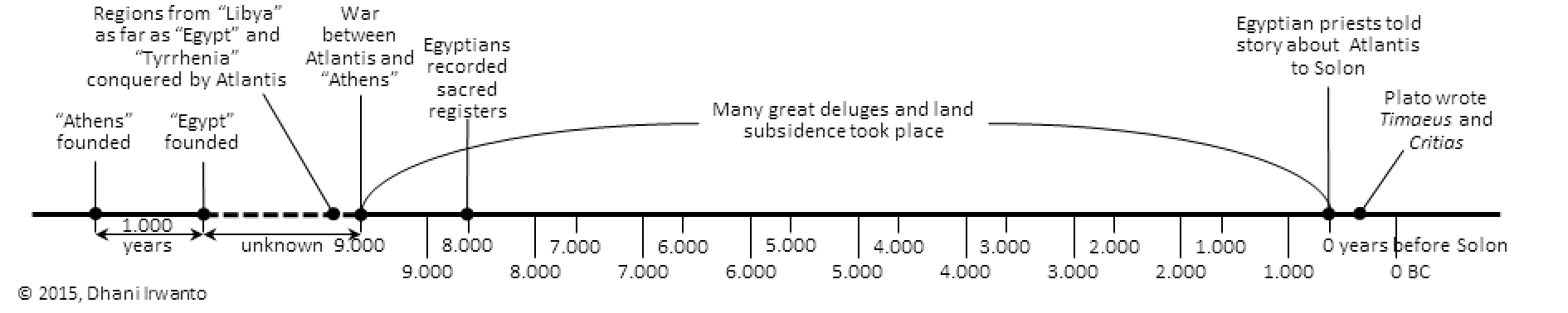
Based on the above narratives, the timeline of Atlantis story is made as below.
Sometimes before 10,000 years before Solon – the “Athens” was founded
Sometimes before 9,000 years before Solon – the “Egyptians” was founded
Shortly before 9,000 years before Solon – the regions from “Libya” as far as “Egypt” and “Europe” as far as “Tyrrhenia” were conquered by Atlantis
9,000 years before Solon – a war between Atlantis and the “Athens” took place
8,000 years before Solon – the Egyptians recorded their sacred registers
Between 9,000 years before Solon and Solon’s time – many great deluges and land subsidence took place
About 600 BC – the Egyptian priests told story about Atlantis to Solon
Kangdez refers to a mythical, paradise-like fortress in Iranian folklore, means “Fortress of Kang”. In Ferdowsi’s Shahnameh, Kangdez becomes Gangdez.
The Middle Persian Pahlavi texts mention Kangdez as being founded by Siyavakhsh (Siavosh in the Shahnameh). In the Bundahishn and Dadestan i-Denig, Kangdez was conquered by Kay Khosrow. In Pahlavi Zoroastrian eschatological works, Kangdez is the abode of Peshotan, son of King Vishtasp, and Khwarsheed-chihr son of Zarathushtra, who will gather their righteous army there before the final battle against Ahriman and his creatures. In Dinkard the previous information is ascribed to the lost Sudgar Nask of the Sassanid Avesta.
In the Shahnameh, Siavosh, having fled from Kay Kavus to Turan, is granted by Turan’s King Afrasiab a pleasant piece of land, where Siavosh erects the castle Kangdez by miraculous power. In other Persian texts, the construction of Kangdez is attributed to Kay Kavus, Kay Khosrow and even Legendary King Jamshid. The region around the castle Kangdez is described as being rich in water and game, and knowing neither the frost of winter nor the heat of summer. It is thirty farsakh square in size (1 farsakh is about 6.2 kilometers). The walled city of Kangdez is also called Kang-e Siavosh, Kang-e Siyavakhsh, Siavoshgerd and Siyavakhshgerd, in different texts. The combination of urban structures and gardens within the city walls, the absence of heat and frost, as well as several (usually seven) walls or buildings made of different materials is a characteristic description of towns in Iranian lore.
According to the Bundahisn, the Kangdez was originally supported on the heads of dews (also in Pahlavi), but was placed on the ground by Kay Khosrow. It had seven ring walls made of gold, silver, steel, brass, iron, crystal, and lapis lazuli (Bundahisn); or stone, steel, crystal, silver, gold, chalcedony and ruby (Pahlavi). It also had hands and feet, and there was eternal spring. Its dimensions were so enormous that it took a man with horse and chariot fifteen days to drive from one of its fifteen gates to the next (Bundahisn), set 700 parasangs (about 3900 kilometers) apart (Pahlavi). Each gate was the height of fifteen men, and the castle itself was so tall that the arrow of the best archers might not reach the top (Pahlavi).
According to the Pahlavi, the Kangdez was, apparently, at first in the other world, but was invited down to the earth by Kay Khosrow, who addressed it as his sister, since it had been made by his father (Siavosh). It came down in eastern Turan, in the area of Siavosh-kerd, and Kay Khosrow settled “the Iranians” in it, who would not leave it until the coming of Pisyotan (Wistasp’s eschatological son) at the end of time. It had a silver tower with golden crenellations, accommodating fourteen mountains and seven rivers in spate. After the end of the Kayanids, Pisyotan will be king and priest in the Kang until the final battles, which he goes out to fight, but then returns and stays until the Renovation.
Siavosh lived in Kangdez until he was cunningly killed by Afrasiab. When he learnt of his father’s murder, Siavosh’s son, Kay Khosrow, pledged vengance. When Kay Khosrow ascended the throne of Iranshahr, he launched a series of expeditions against Turan and Afrasiab, who he eventually defeated. Afrasiab fled to China and from there sails to Kangdez. Kay Khosrow pursues Afrasiab, puts together a naval force, and sets sail for Kangdez which he reaches after a six-month-long voyage, but Afrasiab has already secretly escaped. Kay Khosrow resides in Kangdez for one year and then sails back to Iran through Turanian territory.
In the Sassanid Avesta, the Vourukasha Sea lies in the extreme East from which all waters come with the wind and clouds. It is described as the “deep sea of salt waters”. Reference is made to tides, of the “waters rising up and going down” and of a southern sea into which the Vourukasha empties and from which it refills causing the tidal ebb and flow. In the Vourukasha Sea is Eranvej, where the peak Hukairya is located. On Hukairya is the world spring and world river known as Aredvi Sura Anahita, the source of water for all the “world’s rivers”. Also on this peak grows the sacred “white haoma”.
In latter literature, Siavosh is said to have built Kangdez on the “frontier” of Eranvej. In the Vourukasha Sea is also mentioned the giant ox from whose back was taken the three sacred fires.
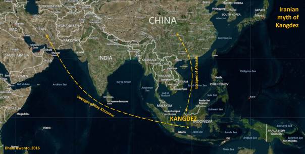
In the Dadestani-Menog i-Khrad, the location of Kangdez is described as “entrusted with the eastern quarter, near to Satavayes on the frontier of Airan-vego”. Satavayes is a star or constellation. According to late Zoroastrian texts, Kangdez was located beyond Khotan (Hotan now) and China, a year’s voyage (six months for Kay Khosrow) to the East by sea from the Baluchi port of Makran. Arab geographer, al-Biruni, identifies Kangdez with another land of Yamakoti, the legendary easternmost town of the Indian oecumene.
The geographers who used Kangdez as the prime meridian belonged to what is known as the al-Balkhi school, after Abu Mashar al-Balkhi, known in the West as Albumasar. During the Middle Ages, Albumasar was the most renowned of Muslim astronomer/astrologers in Europe. His theories of historical cycles linked with the planets influenced many European astrologers including Nostradamus whose key work Revolutions was based on such concepts. Abu Mashar al-Balkhi placed the meridian in the far East, based his geographical canon on Kangdez as 0 degrees longitude. The reference to 0 longitude alludes to the concept that Kangdez is considered the centre of the earth. Al-Kashi in the 15th century places Kangdez at the extreme East or 180 degrees East longitude, and at the equator (0 degrees latitude).
Descriptions of Kangdez mentioned above, including its location at the extreme far east, in a sea (ocean) which could be reached from Iran by sea (a year or six-month’s voyage), situated around the equator, there was no snow, there were two seasons , outside of China, east of India (according to al-Biruni), many rivers, water and mountains, and there was a row of volcanoes ( “giant ox” where from whose back was taken the three sacred fires) indicate that Kangdez is most likely located in Sundaland. The descriptions of the fortress town of Kangdez, among others, consists of rings of walls coated with precious metals and stones, plenty of water and games, there were eternal springs, there was a tower of silver and gold, built by leaders who glorified (Siavosh or Kay Khosrow) with miraculous power, there were rivers and mountains, consists of plains influenced by sea tides, rivers were fed from the mountains and flow towards the south, and was in the marine environment, show that Kangdez approximately has characteristics similar to Atlantis.
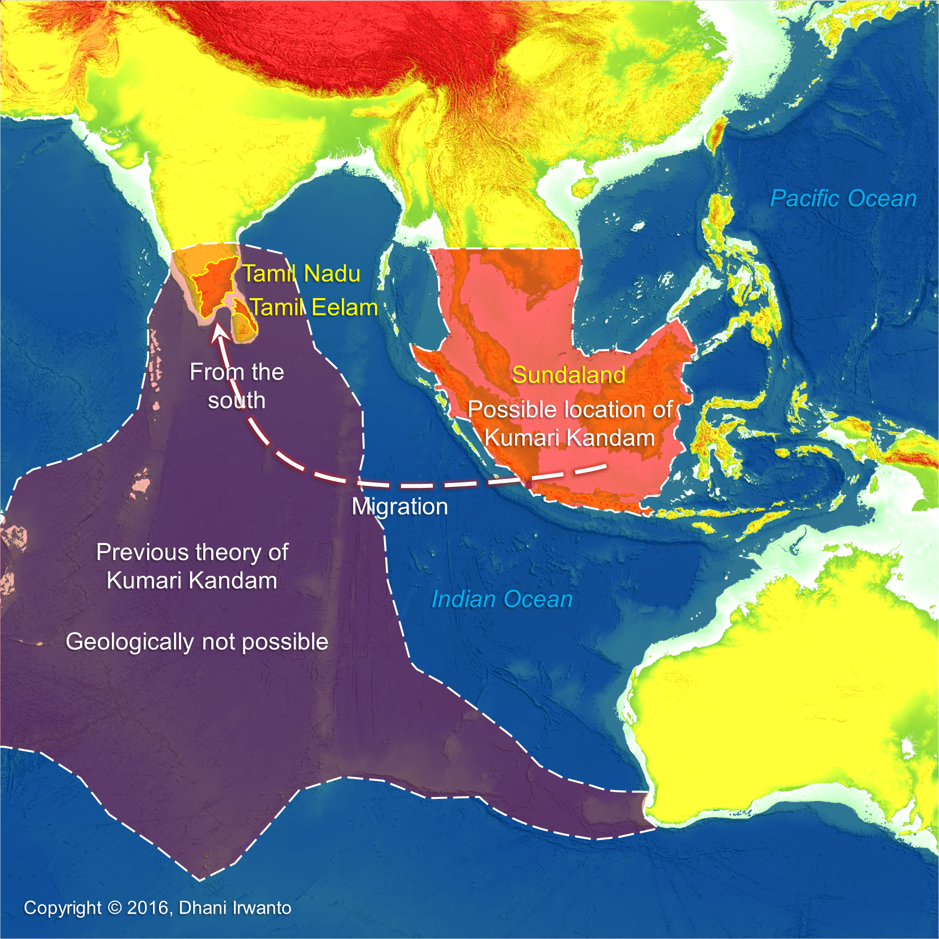
Kumari Kandam refers to a hypothetical lost continent with an ancient Tamil civilization, located south of present-day India, in the Indian Ocean. Alternative names and spellings include Kumarikkantam and Kumari Nadu. Most Tamil revivalists connect it with the Pandyan kingdom mentioned in the works of literary Tamil and Sanskrit.
The words “Kumari Kandam” first appear in Kanda Puranam, a 15th-century Tamil version of the Skanda Purana, written by Kachiappa Sivacharyara (1350 – 1420). Although the Tamil revivalists insist that it is a pure Tamil name, it is actually a derivative of the Sanskrit words “Kumarika Khanda”. The Andakosappadalam section of Kanda Puranam describes the following cosmological model of the universe.
“There are many worlds, each having several continents, which in turn, have several kingdoms. Paratan, the ruler of one such kingdom, had eight sons and one daughter. He further divided his kingdom into nine parts, and the part ruled by his daughter Kumari came to be known as Kumari Kandam after her. Kumari Kandam is described as the kingdom of the Earth.”
Although the Kumari Kandam theory became popular among anti-Brahmin anti-Sanskrit Tamil nationalists, the Kanda Puranam actually describes Kumari Kandam as the land where the Brahmins also reside, where Shiva is worshipped and where the Vedas are recited. The rest of the kingdoms are described as the territory of the Mlecchas.
Multiple ancient and medieval Tamil and Sanskrit works contain legendary accounts of lands in South India being lost to the ocean. The earliest explicit discussion of a katalkol (“seizure by ocean”, possibly the sea water rise) of Pandyan land is found in a commentary on Iraiyanar Akapporul. This commentary, attributed to Nakkeerar, is dated to the later centuries of the 1st millennium CE. It mentions that the Pandyan kings, an early Tamil dynasty, established three literary academies (sangams). The first two sangams were not located in South India now but in an ancient Tamil country in the south which then sank. The first sangam flourished for 4,400 years in a city called Tenmaturai, attended by 549 poets (including Agastya) and presided over by gods like Shiva, Kubera and Murugan. The second sangam lasted for 3,700 years in a city called Kapatapuram, attended by 59 poets (including Agastya, again). The commentary states that both the cities were “seized by the ocean”, resulting in loss of all the works created during the first two sangams. The third sangam was established in Uttara (North) Madurai, where it is said to have lasted for 1,850 years. The Pandyan capital of Kapatapuram finds mention in the Ramayana and Chanakya’s Arthasastra (ca 4th century BCE).
Nakkeerar’s commentary does not mention the size of the territory lost to the sea. The size is first mentioned in a 15th-century commentary on Silappatikaram. The commentator Adiyarkunallar mentions that the lost land extended from Pahruli river in the north to the Kumari river in the South. It was located to the south of Kanyakumari, and covered an area of 700 kavatam (a unit of unknown measurement). It was divided into 49 territories (natu), classified in seven categories: elu teñku natu (“seven coconut lands”), elu maturai natu (“seven mango lands”), elu munpalai natu (“seven front sandy lands”), elu pinpalai natu (“seven back sandy lands”), elu kunra natu (“seven hilly lands”), elu kunakarai natu (“seven coastal lands”) and elu kurumpanai natu (“seven dwarf-palm lands”).
A mountain range had forty-eight high peaks. Four rivers were originated from Meru Malai: Kumari Aaru, Peru Aaru, Pahruli Aaru and Kanni Aaru. The Pahruli river was excavated to irrigate the mountain valley by the Pandyan King Nediyon. Ruby was mined from the mountain Mani Malai and gold from Meru Malai. It is said that Chinese laborers were employed by the Pandyan King and when they went down the mines they appeared like a huge army of small ants, therefore, they were called “the gold mining ants”.
Other medieval writers, such as Ilampuranar and Perasiriyar, also make stray references to the loss of antediluvian lands to the south of Kanyakumari, in their commentaries on ancient texts like Tolkappiyam. Another legend about the loss of Pandyan territory to the sea is found in scattered verses of Purananuru (dated between 1st century BCE and 5th century CE) and Kaliththokai (6th – 7th century CE). According to this account, the Pandyan king compensated the loss of his land by seizing an equivalent amount of land from the neighboring kingdoms of Cheras and Cholas.
Kumari Kandam is a Tamil legend about ancient civilization geographically located in the Indian Ocean and then sank into the ocean. Though many Tamil writers do not assign any date to the submergence of Kumari Kandam, resorting to phrases like “once upon a time” or “several thousands of years ago”, but the stories are consistent with the theory of post-glacial been widely acceptable by scientists. This ancient Tamil civilization was located south to Tamil now, or to go to their new land they reached from the south. Vast land which sank in the geological past is not other than Sundaland. Previous theories hypothesized that the vast mainland of Kumari Kandam was located in the south of the Indian subcontinent, but the theory of tectonic plate movement does not support the existence of such land within some thousands years back. It can be presumed that Kumari Kandam is having a relationship with Atlantis or other civilizations thereafter.
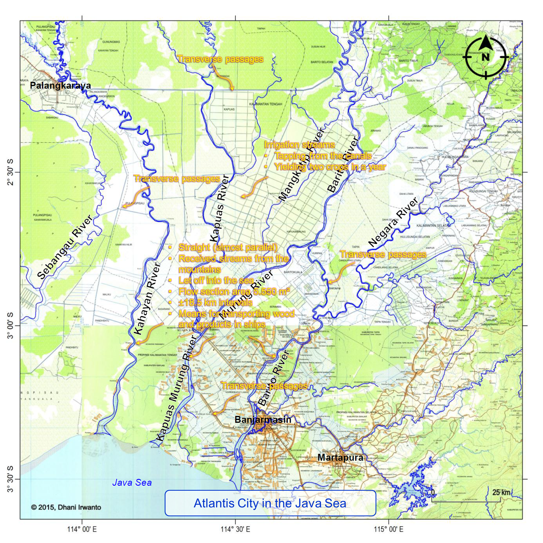
The years of the three stages of sangams are summed up to a date between 11,000 and 12,000 years BP, almost the similar number by the Plato’s dating on Atlantis of 11,600 BP, which could relate the Pandyan Kingdom to Atlantis. The mentions of mountain ranges which had forty-eight high peaks, the four rivers originated from the mountains, and the mining of gold and precious stones coincidentally match the Biblical Garden of Eden hypothesized by the author in the southern Kalimantan. The mountain Meru Malai, where there were mountain ranges which had forty-eight high peaks coincidentally match the Malea Mountains in the Ptolemy’s account of Taprobana, in which the author hypothesizes as the Malawi region in Kalimantan on the Schwaner-Muller mountain ranges. These mountain ranges have tens of peaks, to the south lays an expanse of alluvial plain and the origins of four main rivers: Kahayan, Kapuas, Barito and Negara. The Pahruli river excavated for irrigation purposes also coincidentally match the Plato’s description of Atlantis.
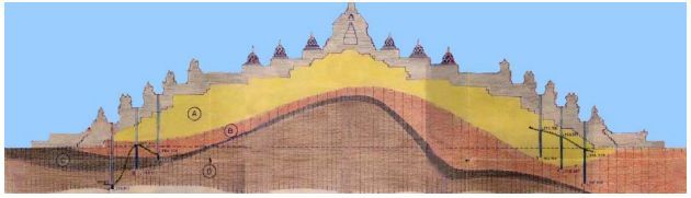
In Timaeus Section 24e Plato describes that the country of Atlantis was larger than Libya and Asia Minor put together, and was the way to other islands, and from these you might pass to the whole of the opposite continent which encompasses the true ocean.
Plato describes the Atlantis Plain plain was level, surrounded by mountains which descended towards the sea, smooth and even, rectangular and oblong shaped, three thousand stadia (about 555 kilometers) long, two thousand stadia (about 370 kilometers) wide, looked towards the south, sheltered from the north, surrounded by mountains celebrated for their number, size and beauty; and had wealthy villages of country folk, rivers, lakes, and meadows.
There were four kinds of channels: the circular (perimeter) ditch, the inland channels, the transverse passages and the irrigation streams. The perimeter ditch was artificial, 100 feet (about 30 meters) deep, 1 stadium (about 185 meters) wide, 10,000 stadia (about 1,850 kilometers) long, carried round the whole plain, received streams from the mountains, winding around the plain, meeting at the city and let off into the sea. The inland canals were straight, 100 feet (about 30 meters) wide, 100 stadia (about 18.5 kilometers) intervals, let off into the perimeter ditch and as means for transporting wood and products in ships. The transverse passages were cut from one inland canal into another. The irrigation streams tapping from the canals were meant to irrigate the land in the summer (dry season) while in the winter (rainy season) had the benefit of the rains.
Coral reefs are diverse underwater ecosystems held together by calcium carbonate structures secreted by corals. Coral reefs are built by colonies of tiny animals found in marine waters that contain few nutrients. Most coral reefs are built from stony corals, which in turn consist of polyps that cluster in groups. The polyps belong to a group of animals known as Cnidaria, which also includes sea anemones and jellyfish. Unlike sea anemones, corals secrete hard carbonate exoskeletons which support and protect the coral polyps. Reefs grow best in warm, shallow, clear, sunny and agitated waters.
Coral reefs begin to form when free-swimming coral larvae attach to submerged hard surfaces. As the corals grow and expand, reefs take on one of three major characteristic structures – fringing, barrier or atoll. Fringing reefs, which are the most common, project directly from the hard surfaces, forming reefs and expand in horizontal and vertical directions. Barrier reefs also project, but at a greater distance. If a fringing reef forms around a rocky island that subsides completely below sea level while the coral continues to grow upward, an atoll forms.
The Sunda shelf was exposed during the Ice Age, the most recent glacial period occurring during the last years of the Pleistocene, from approximately 110,000 to 12,000 years ago. It was in the Sundaland that man first found the ideal climatic conditions for development, and it was there that he invented farming, structure building, seafaring and civilization from 70,000 years ago. People of these civilizations were dependent on water for their mobilizations, so coastal areas were the most suitable places to live and then communities were formed there. They used stones and woods to build houses and other buildings since these materials were abundant in the region.
The Ice Age waned during the period 14,000 – 7,000 years ago that accompanied by sea level rise – as much as 130 m. The costal communities then moved to adjust the changing coastlines and remnants of their buildings were left sank under the sea. Finding the most suitable places to grow, coral reefs were formed on these buildings.
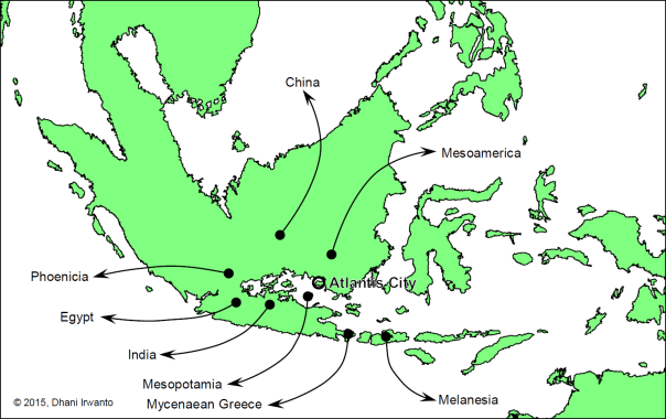
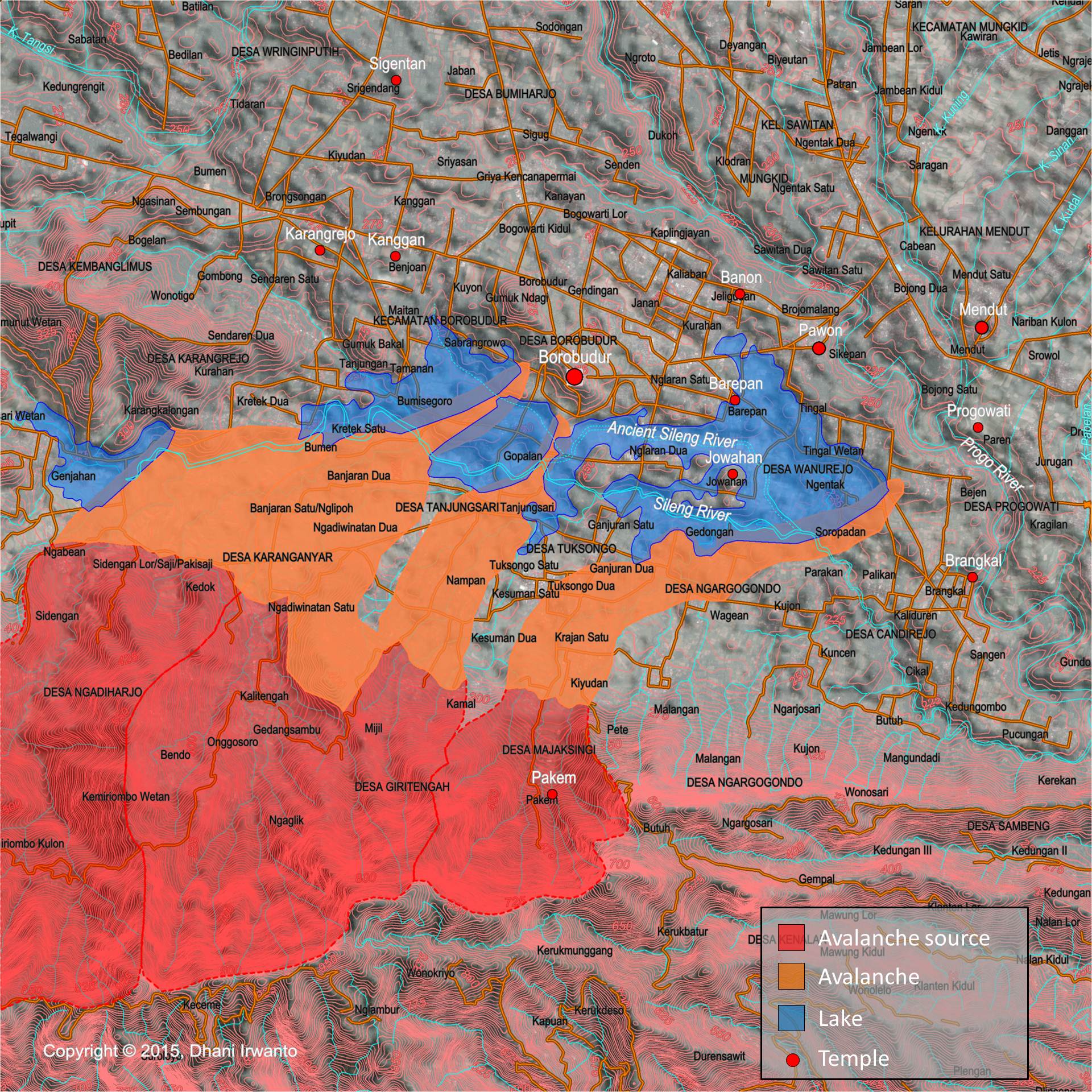
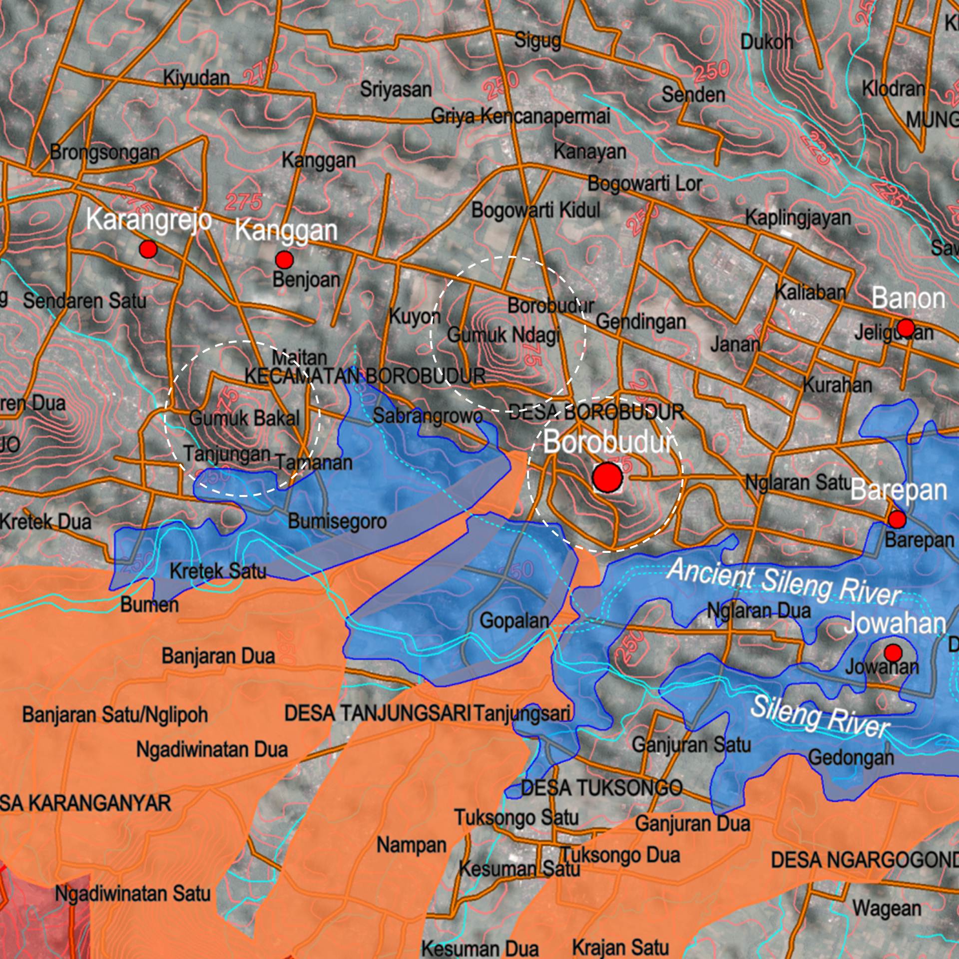
Based on the data of coral reefs and bathymetric maps, the author identifies the probable sites and ages of the ancient civilizations, as shown on the attached map. Note that not all of the coral reef sites were ancient civilizations because coral reefs could form on natural hard surfaces as well.
According to Plato’s narrative, Atlantis ended at around 11,600 years ago. Based on the above study, the location of the capital city of Atlantis is expected at one of the very ancient civilization sites shown on the map. Plato also wrote that the capital city of Atlantis at Solon’s time had been covered by a coral reef so it was not navigable.
The author conjectures the origins of post-deluge civilizations of Atlantis as shown on the figure below. What did they bring?
Conjecture of origins of post-deluge civilizations
1. Civilization – As written by many authors, humanity was first flourished in Sundaland where ideal climatic conditions for development were found, and it was there that they invented farming, agriculture, trading and civilization.
2. Language – Scholastic belief by etymologists and linguists are positive that all world languages sprang from a common source. Paleo-Sanskrit is one of the theories that it is the ancestor of Sanskrit, Indo-Iranian, Indo-European, Mesoamerican, Sino-Tibetan, Austronesian and all other languages of the world.
3. Myths and doctrines – All the gods and goddesses of various world religions are parallel. Similar myths of great floods, creation and heaven are found all over the world. Brahma, Abram, Avram, Abraham and Ibrahim are believed by some as the same person.
4. Pyramid building – There are hundreds of pyramids still standing all over the world. Cultures separated by oceans, who supposedly never discovered each other’s existence, built these giant triangular structures, aligned them to cardinal directions, encoded within them sacred geometry/math, and used them as sepultures. The Gunung Padang pyramid in West Java, Indonesia dated 23,000 BC or earlier is claimed to be the earliest one.
5. Boat and ship building – Boat and ship have been the instrumental in the development of civilization, affording humanity greater mobility than travel over land, whether for trade, transport or warfare, and the capacity for fishing. Similarities among boat and ship building technology in the Austronesian and other parts of the world were observed. The earliest seaworthy boats may have been developed as early as 40,000 years ago, according to one hypothesis explaining the habitation of Melanesia and Australia.
Land of Punt: In Search of the Divine Land of the Egyptians
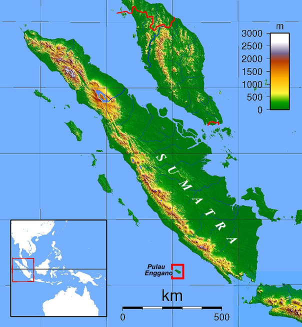
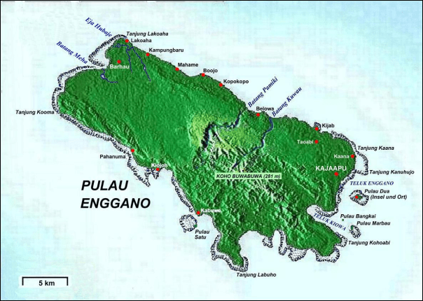
This book presents the latest research about the Land of Punt – the Divine Land or the Land of Gods or the Land of Origin of the ancient Egyptians. After gathering abundance of converging evidence, the author argues that the Land of Punt is located in Sumatera, Indonesia.
The Land of Punt was a trading partner of Egypt, it was known for producing and exporting gold, incense, aromatic resins, cinnamon, ebony, ivory and animals. The region is known from ancient Egyptian records of trade expeditions to it. The Egyptians were continuously in trading relationship with the Puntites, as recorded in their history from the 4th to the 26th Dynasties (27th – 6th centuries BC). The most famous Egyptian expedition to Punt, and the one from which we derive most of our information is the one conducted by 18th-dynasty Queen Hatshepsut (1473 – 1458 BC) and recorded in the splendidly detailed reliefs on the walls of her mortuary temple at Deir El-Bahari, Egypt.
The exact location of the Land of Punt is unknown, and through the years it has been cited as part of Arabia, the Horn of Africa, present-day Somalia, the Sudan or Eritrea. The debate goes on as to where Punt was located, with scholars and historians on every side offering plausible supports for their claims.
After gathering abundance evidence among others as listed below, the author makes a hypothesis that the Land of Punt is located in Sumatera, Indonesia.
The Land of Punt, also called Pwenet or Pwene by the ancient Egyptians, was a trading partner of Egypt, it was known for producing and exporting gold, incense, aromatic resins, ebony, ivory, tortoise shells and wild animals. The region is known from ancient Egyptian records of trade expeditions to it. Some biblical scholars have identified it with the biblical land of Put.
The first clear mention of Punt comes from the Old Kingdom. As the so-called Palermo Stone tells us, about 2500 BC during the reign of King Sahure, an expedition to Punt returned with 80,000 measures of ‘ntyw (ånti), which scholars believe to be frankincense. Derived from a tree of the same name, frankincense is a resin used to make incense, which the Egyptians coveted for temple rituals; frankincense was the most prized commodity from Punt. Sahure’s expedition also brought back 23,030 staves – wood being precious to a desert country like Egypt – and 6,000 measures of electrum, a natural alloy of gold and silver, among other items. Fragments from the decoration of this king’s mortuary temple at Abusir are interpreted as a representation of the inhabitants of Punt.
The Egyptians called the Land of Punt Ta Natjer. Literally translated, this means the Land of the Gods. Since Ra, the sun god, held a very important place in the Egyptian pantheon, historians believe that Punt was referred to as the Abode of the Gods because of its location to the east of Egypt, in the direction of the sunrise. The name could also refer to the superior wood imported from Punt, which went into the building of Egyptian temples and to the frankincense and other aromatic incense brought from Punt that were used extensively in religious rituals of the ancient Egyptians.
Older literature (and current non-mainstream literature) maintained that the label “Land of God”, when interpreted as “holy land” or “land of the gods/ancestors” or “divine land”, meant that the ancient Egyptians viewed the Land of Punt as their ancestral homeland. WM Flinders Petrie believed that the Dynastic Race came from or through Punt and EA Wallis Budge stated that the Egyptian tradition of the Dynastic Period held that the aboriginal home of the Egyptians was Punt.
The exact location of the Land of Punt is unknown, and through the years it has been cited as part of Arabia, the Horn of Africa, present-day Somalia, the Sudan or Eritrea. The debate goes on as to where Punt was located, with scholars and historians on every side offering plausible supports for their claims.
A 4th Dynasty relief shows a Puntite with one of Pharaoh Khufu’s sons, and in the 5th Dynasty documents show regular trade between the two countries. Among the many treasures brought to Egypt from Punt were gold, ebony, wild animals, animal skins, ivory, tortoise shells, spices, precious woods, cosmetics, frankincense and frankincense trees. The roots of the incense trees brought back from Punt by Hatshepsut’s expedition in 1493 BC can still be seen outside of her complex at Deir al-Bahari.
In the 12th Dynasty, Punt was immortalized in Egyptian literature in the very popular Tale of the Shipwrecked Sailor in which an Egyptian sailor converses with a great serpent who calls himself the “Lord of Punt” and sends the sailor back to Egypt laden with gold, spices and precious animals. Perhaps because of this tale Punt became more and more a semi-mythical land to the Egyptians and, after Hatshepsut’s voyages there, no more is written about it in any factual way. Punt came to hold a strange fascination for the Egyptian people as a “land of plenty” and was known as Te Netjer, the Land of the Gods from which all good things came to Egypt. Punt was also associated with Egyptian ancestry in that it came to be seen as their ancient homeland and, further, the land where the gods lived. Exactly why Punt was elevated from reality into mythology is not known but, after the 18th Dynasty, the land receded further and further in the minds of the Egyptians until it was lost in legend and folklore.
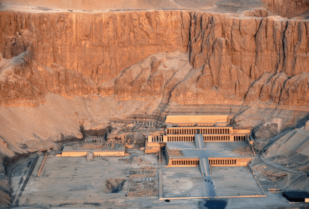
The most evidence about the land of Punt comes from a temple dedicated to the female pharaoh Hatshepsut, the 18th Dynasty of Egypt, who ruled for more than 20 years circa 1465 BC. A large relief of a trading mission to Punt is featured on the walls of the temple, known for Queen Hatshepsut’s famous expedition in 1493 BC, which brought back living trees to Egypt, marking the first known successful attempt at transplanting foreign fauna. We even know the names of the rulers of Punt during Hatshepsut’s reign: Parehu and his wife Ati. Reliefs on the walls of her temple there show the chief of the Puntites and his wife receiving the envoys from Egypt. From the descriptions that survived, the land of Punt was a peaceful and prosperous country that seemed to have a wide variety of highly valued goods to trade.
The earliest recorded Egyptian expedition to Punt was organized by Pharaoh Sahure of the Fifth Dynasty (25th century BC). However, gold from Punt is recorded as having been in Egypt as early as the time of Pharaoh Khufu of the Fourth Dynasty.
Subsequently, there were more expeditions to Punt in the Sixth, Eleventh, Twelfth and Eighteenth dynasties of Egypt. In the Twelfth Dynasty, trade with Punt was celebrated in popular literature in the Tale of the Shipwrecked Sailor.
In the reign of Mentuhotep III (11th dynasty, ca 2000 BC), an officer named Hannu organized one or more voyages to Punt, but it is uncertain whether he personally traveled on these expeditions. Trading missions of the 12th dynasty pharaohs Senusret I, Amenemhat II and Amenemhat IV had also successfully navigated their way to and from the mysterious land of Punt.
In the Eighteenth Dynasty of Egypt, Hatshepsut built a Red Sea fleet to facilitate trade between the head of the Gulf of Aqaba and points south as far as Punt to bring mortuary goods to Karnak in exchange for Nubian gold. Hatshepsut personally made the most famous ancient Egyptian expedition that sailed to Punt. During the reign of Queen Hatshepsut in the 15th century BC, ships regularly crossed the Red Sea in order to obtain bitumen, copper, carved amulets, naptha and other goods transported overland and down the Dead Sea to Elat at the head of the gulf of Aqaba where they were joined with frankincense and incense coming north both by sea and overland along trade routes through the mountains running north along the east coast of the Red Sea.
Hatshepsut’s 18th dynasty successors, such as Thutmose III and Amenhotep III also continued the Egyptian tradition of trading with Punt. The trade with Punt continued into the start of the 20th dynasty before terminating prior to the end of Egypt’s New Kingdom. From here on, trade contacts seem to have been non-existent and with but a single exception, references to Punt envisage it as a fabled and magical land. The exception is a reference to the Mountain of Punt which occurred as an inscription on a damaged stela found at Tel Defenneh dating back to the 26th Dynasty. It also declares a miracle and a blessing that there was rain upon the Mountain of Punt in late December/early January.
Queen Hatshepsut is a daughter of Thothmes I, third Pharaoh of the Eighteenth Dynasty, and of his wife, Queen Ahmes Nefertari. She inherited sovereign rights in virtue of her maternal descent from the old Twelfth Dynasty line.
The story of Hatshepsut’s expedition to the Land of Punt is recorded for posterity in the Egyptian art on the wall of her memorial temple at Deir el-Bahari (Arabic for “The Northern Monastery”), a complex of mortuary temples and tombs located on the west bank of the Nile. It is separated from the Valley of the Kings by the peak of el-Qurn (Arabic for “The Horn” known to the Egyptians as “Dehent”) and lies directly across the water from the temple complexes at Karnak and Luxor in Thebes. The mountain formed a natural pyramid towering over the Valley of the Kings and Deir el-Bahari, and was sacred to Hathor and Meretseger.
The first to leave a description of the abandoned Coptic monastery that had once stood on top of the ruins of the temple of Hatshepsut was the famous English explorer Richard Pococke who stopped here in 1737. Jean-François Champollion copied the texts from the temple’s granite portals and the walls of the Main Sanctuary of Amon-Ra. John Gardner Wilkinson introduced the name Deir el-Bahari (“Northern Monastery”) in world literature in 1835. Richard Lepsius followed with the identification of the ruins as a temple of Hatshepsut.
Regular excavations were started by French archaeologist Auguste Mariette (1821 – 1881), the founder of the Egyptian Antiquities Service. Archaeological investigations of the Deir el-Bahari complex were begun in 1881, after objects belonging to the missing pharaohs began to turn up in the antiquities market. French archaeologist Gaston Maspero (1846 – 1916), director of the Egyptian Antiquities Service at the time, went to Luxor in 1881 and began to apply pressure to the Abdou El-Rasoul family, residents of Gurnah who had for generations been tomb robbers.
The first institution of great merit for Egyptological studies was a mission of the Egypt Exploration Fund (EEF) directed by French archaeologist Edouard Naville (1844 – 1926). Excavations at the temple began in the 1890s. Between 1893 and 1899 it managed to clear the Upper Terrace and most of the buried courtyards, chapels and colonnades. Roofs were installed over the Portico of the Obelisks and the porticoes of the Middle Terrace. The walls of the Main Sanctuary of Amon-Ra were reinforced and a provisional protection was carried out of the Sun Altar, Royal Cult complex, Hathor Chapel and Lower Northern Portico. In 1911, Naville turned over his concession on Deir el-Bahari (which allowed him sole excavator’s rights), and the legendary Herbert Winlock began what would be 25 years of excavation and restoration. Winlock arrived in Deir el-Bahari at the head of a mission of the Metropolitan Museum of Art which stayed there for the next twenty years (1911 – 1931), penetrating the terraces and the two ramps of the uncovered temple.
When Leszek Dąbrowski came with his group of specialists from Warsaw University’s Centre of Mediterranean Archaeology (PCMA), they found row upon row of decorated blocks arranged by their illustrious predecessors, waiting to be restored to their original positions in the walls, columns and architraves of the temple. The Poles had been invited to take over the project by the Egyptian Antiquities Organization. Kazimierz Michałowski remained at the head of this mission from its inception in the autumn of 1961 to his death in 1981.
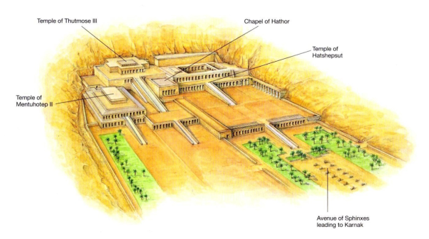
The first pharaoh to build at Deir el Bahari was Nebhepetre Montuhotep II, of the Eleventh Dynasty who reunified the country after the First Intermediate Period. He chose to build his Mortuary Temple and tomb at Deir el-Bahari instead of with those of his predecessors at Dra Abu el Naga and also pioneered a new architectural style which despite its fresh look seems to have been inspired by the form of Old Kingdom pyramid complexes. He constructed a Valley Temple (now completely destroyed) connected by a long causeway to a Mortuary Temple which he named Akh Sut Nebhepetre (“Splendid are the places of Nebhepetre”). The Mortuary Temple consisted of a terrace perched against the cliff with a large stone edifice (described as a mastaba by some and a pyramid by others) above it and a deep shaft to his tomb below it.
The tombs of six princesses were found within the enclosure of the Mortuary Temple of Montuhotep. The tombs were excavated during the first phase of construction but their entrances were covered with masonry when the temple was enlarged. Each tomb contained a sarcophagus formed out of six large slabs joined together with metallic strips. Each sarcophagus was beautifully decorated with scenes of daily life and the presentation of offerings.
Many of Montuhotep’s officials were buried in tombs excavated from the cliffs around his Mortuary Temple including; the chancellor Akhtoy, viziers Dagi (TT103 Sheikh Abd el-Qurna) and Ipi (TT315 Deir el-Bahari), the treasurer Khety (TT311 Deir el-Bahari), royal guardsman Horhotep (TT314 Deir el-Bahari) and chief steward Henenu (TT313 Deir el-Bahari). There is also a mass grave in which sixty soldiers were interred. It is thought that they all died during active service in Nubia and were given the honor of being buried close to their pharaoh.
Amenhotep I built a temple at Deir el-Bahari and buried his Great Royal Wife (Ahmose-Meritamun) nearby in Theban Tomb. However, Amenhotep’s temple was in the prime spot chosen by Hatshepsut for her Mortuary Temple and so it was dismantled in order to allow her monument to be constructed. It seems that the original plan was to build her mortuary temple beside his, but the addition of the lower terrace meant that it had to be removed in its entirety. The only remaining evidence that the temple existed are a few bricks inscribed with Amenhotep’s name. The statues of the pharaoh were moved to Montuhotep’s Mortuary Temple.
Hatshepsut built the largest, best preserved and arguably the most impressive temple at the site, her Mortuary Temple named Djeser-Djeseru (“Holy of Holies”), best-preserved of the three complexes. Her Mortuary Temple is clearly inspired by that of Montuhotep and was built so that the colonnades at each side of the central ramp her temple correspond with the two levels of Montuhotep’s Mortuary Temple. After her death her temple was vandalized by Thuthmosis II and then by Akhenaten (because of his antipathy towards Amon).
Senenmut (who was Hatshepsut’s adviser, tutor to her daughter and possibly her lover) was given the honor of having a tomb (TT353 Deir el-Bahari) constructed within the precinct of her Mortuary Temple. He also had a tomb built in Sheikh Abd el-Qurna (TT71) and so the tomb at Deir el-Bahari is known as the “secret” tomb. It was badly damaged in antiquity, but some of the decoration is still visible. It is an unusually large tomb but it was not finished and Senenmut was buried in his other tomb. Unfortunately for him, his other tomb was also vandalized.
Thuthmosis III also built a temple complex here which he dedicated to Amon. It was intended to replace Hatshepsut’s Mortuary Temple as the focus of the “Beautiful Festival of the Valley” but was badly damaged during the Twentieth Dynasty. After that time it was used a source of building materials and in Christian times became the site of a Coptic cemetery.
During the 1870’s a number of items from ancient tombs appeared for sale in Egypt. Following investigations by Maspero and his assistant Brugsch it was confirmed that a family living in the village of Qurna had discovered a tomb and had been looting items over a period of years. Ironically, the tomb (listed as TT320 or DB320) turned out to house a number of pharaohs who had been moved there in order to protect them from tomb robbers. The cache held over fifty mummies including those of King Seqenenre Taa II, Ahmose I, Amenhotep I, Tutmosis I, II and III, Seti I and Ramesses II, III, and IX, Pinudgjem I and II and Siamun.
A cache of 163 reburied mummies of the Priests of Amon were also found in a tomb at Bab el Gasus. It is thought that these priests were the ones who organized the reburial of the pharaohs mummies in TT320.
During the Ptolemaic period, Hatshepsut’s Mortuary Temple was adapted to form a shrine to Amenhotep son of Hapu and Imhotep. In the Late Period the place was frequented by a group of ironworkers from Hermonthis.
In the mid-1970s Abdel Monem Abdel Haleem Sayed of the University of Alexandria, Egypt, conducted test excavations at Wadi Gawasis, and found potsherds with painted (hieratic) inscriptions and inscribed stelae recording expeditions to Bia-Punt (the “mine” of Punt) from a locality called Sʒww, from the reigns of Senusret I, Amenenhat II, Senusret II and Senusret III. Sayed also uncovered some carved, round-topped anchors and a fragment of carved cedar timber with a mortise, most likely from a ship. Based on this evidence Sayed suggested that Mersa/Wadi Gawasis was the pharaonic port of Sʒww for seafaring expeditions to Punt in the Twelfth Dynasty. Another unearthing actual evidence of trade with Punt occurred during excavations beginning in 2001. Here, a team led by Kathryn Bard and Rodolfo Fattovich revealed ceremonial structures, ship timbers, stone anchors, ropes, and other artifacts dating to early and later Twelfth Dynasty. They also uncovered actual products presumably brought from Punt, including carbonized ebony woods and obsidian (a volcanic glass), as well as blades of a steering oar. They even found cargo boxes bearing painted hieroglyphic text describing the contents as the “wonderful things of Punt” (Bard, 2011).
Archaeological evidence including pictures on pottery and rocks suggest that a species of cattle, zebu or brahman (Bos indicus) originating in South Asia, were present in Egypt around 2000 BC. Bos indicus are believed to have first appeared in Sub-Saharan Africa between 700 and 1500 AD, and were introduced to the Horn of African around 1000 AD (Marshall, 1989).
At the Radiology Clinic of the Bonn Universitätsklinikum, the corpus delicti – a plain flacon from among the possessions of Pharaoh Hatshepsut – was subjected to computerized axial tomography scan (CAT scan) in 2011. It became obvious very quickly that what they had found was not dried-up perfume. The mix contained large amounts of palm oil and nutmeg apple oil.
The walls of Djeser-Djeseru are illustrated with Hatshepsut’s autobiography, including stories of her fabled trip to the Land of Punt. Also discovered at Djeser-Djeseru were the intact roots of incense trees, which once decorated the front façade of the temple. These trees were collected by Hatshepsut in her expedition to Punt; according to the histories, she brought back five shiploads of goodies, including flora and fauna.
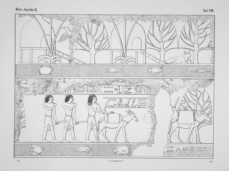
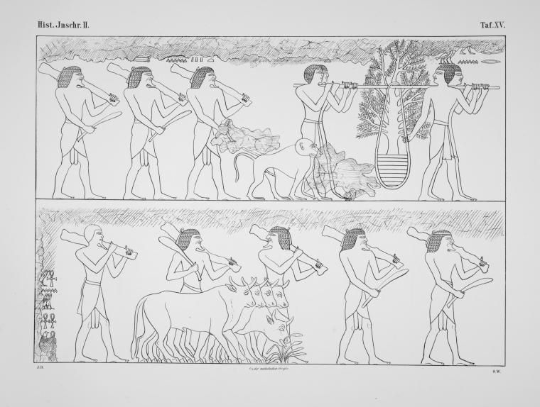
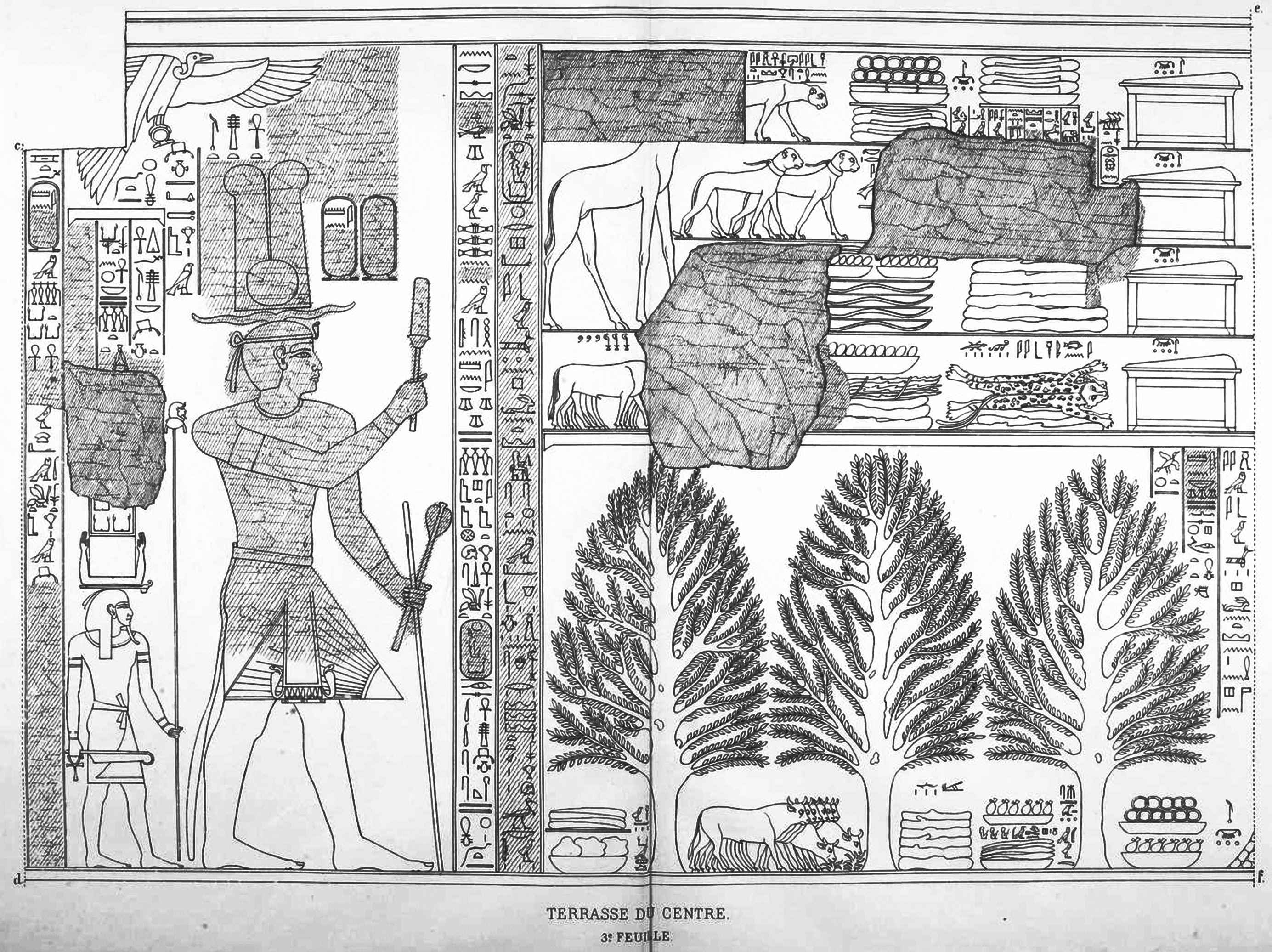
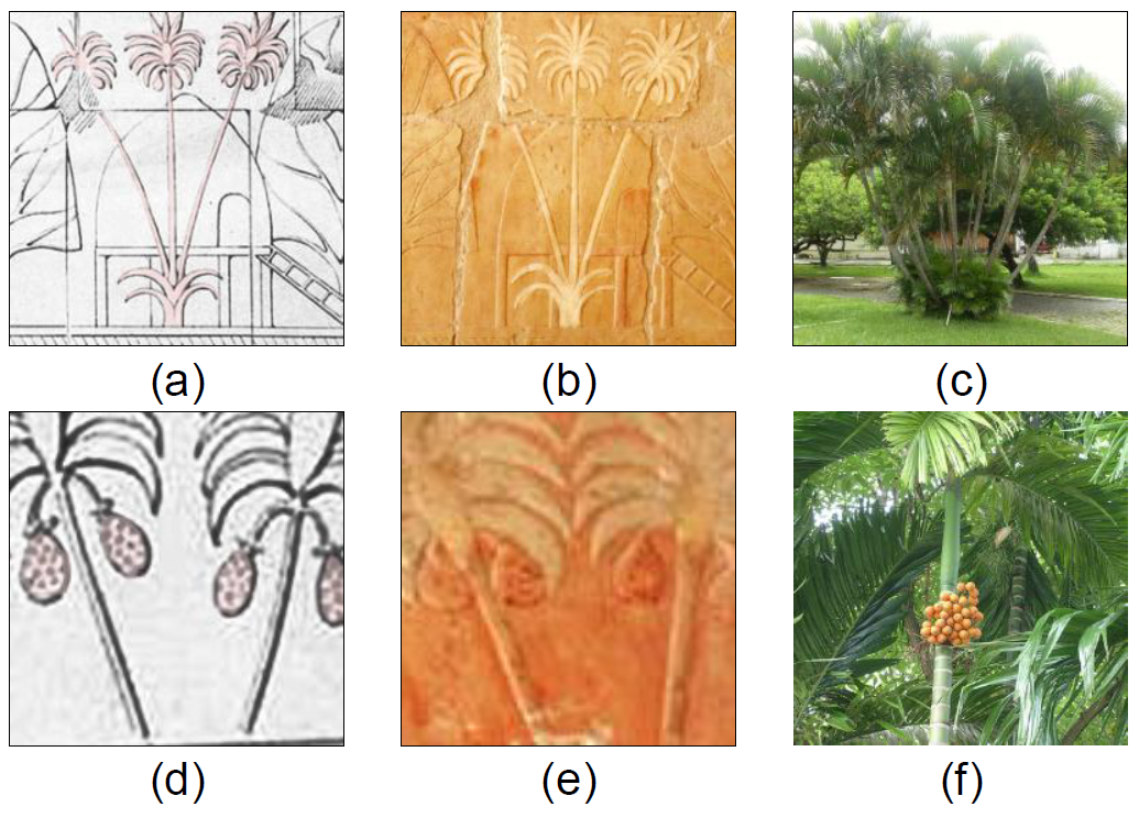
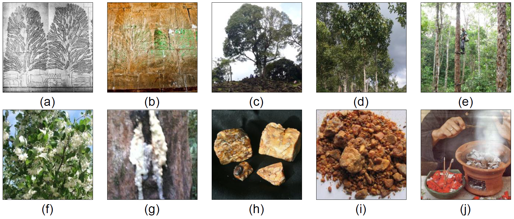
The author presents illustrations of wall-sculptures on middle colonnade of Deir el-Bahari (Djeser-Djeseru) made by Johannes Duemichen (1869), Auguste Mariette (1877) and Eduard Naville (1898) below. Most of the descriptions and hieroglyph transliterations are cited from Naville’s and Edwards’ reports, omitting their personal opinions and adding information by other authors.
Figure 2. Illustrations of wall-sculptures on middle colonnade of Deir el-Bahari (Johannes Duemichen, 1869)
Figure 3. Illustrations of wall-sculptures on middle colonnade of Deir el-Bahari (Auguste Mariette, 1877)
A report of that five-ship voyage survives on reliefs in Hatshepsut’s mortuary temple at Deir el-Bahari. Throughout the temple texts, Hatshepsut maintains the fiction that her envoy Chancellor Nehsi, who is mentioned as the head of the expedition, had travelled to Punt “in order to extract tribute from the natives” who admit their allegiance to the Egyptian pharaoh. In reality, Nehsi’s expedition was a simple trading mission to a land, Punt, which was by this time a well-established trading post. Moreover, Nehsi’s visit to Punt was not inordinately brave since he was accompanied by at least five shiploads of Egyptian marines and greeted warmly by the chief of Punt and his immediate family. The Puntites traded not only in their own produce of incense, ebony and short-horned cattle, but also gold, ivory and animal skins. According to the temple reliefs, the Land of Punt was ruled at that time by King Parehu and Queen Ati. This well illustrated expedition of Hatshepsut occurred in year 9 of the female pharaoh’s reign with the blessing of the god Amon:
“Said by Amon, the Lord of the Thrones of the Two Land: ‘Come, come in peace my daughter, the graceful, who art in my heart, King Maatkare [ie Hatshepsut] … I will give thee Punt, the whole of it … I will lead your soldiers by land and by water, on mysterious shores, which join the harbors of ảnti … They will take ảnti as much as they like. They will load their ships to the satisfaction of their hearts with trees of green [ie fresh] ảnti, and all the good things of the land.’”
Figure 4. Egyptian boats arriving at Punt (Eduard Naville, 1898)
Figure 5. Egyptian boats arriving at Punt (Eduard Naville, 1898) (continued)
The description of the expedition begins with these two figures. Here we see five Egyptian ships arriving. The first two are already moored, and have struck their sails, while the three others are coming up with canvas spread; on the last one the reis or pilot gives the word of command: “to the port side”. The first ship has sent out a boat, which is unloading bags and large jars or amphoras, probably containing the food and drink which is to be presented to the chief of Punt. The inscription in large characters above the ships is as follows:
“The navigation on the sea, the starting on the good journey to the Divine Land, the landing happily in the Land of Punt by the soldiers of the king, according to the prescription of the lord of the gods, Amon, lord of the thrones of the two lands, in order to bring the precious products of the whole land, because of his great love towards [here the name of Hatshepsut is erased with some signs which followed, and it has been replaced by the name of Rameses II] …… to the kings who were in this land eternally.”
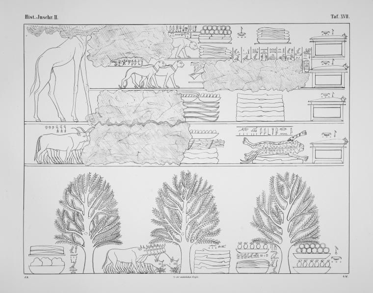
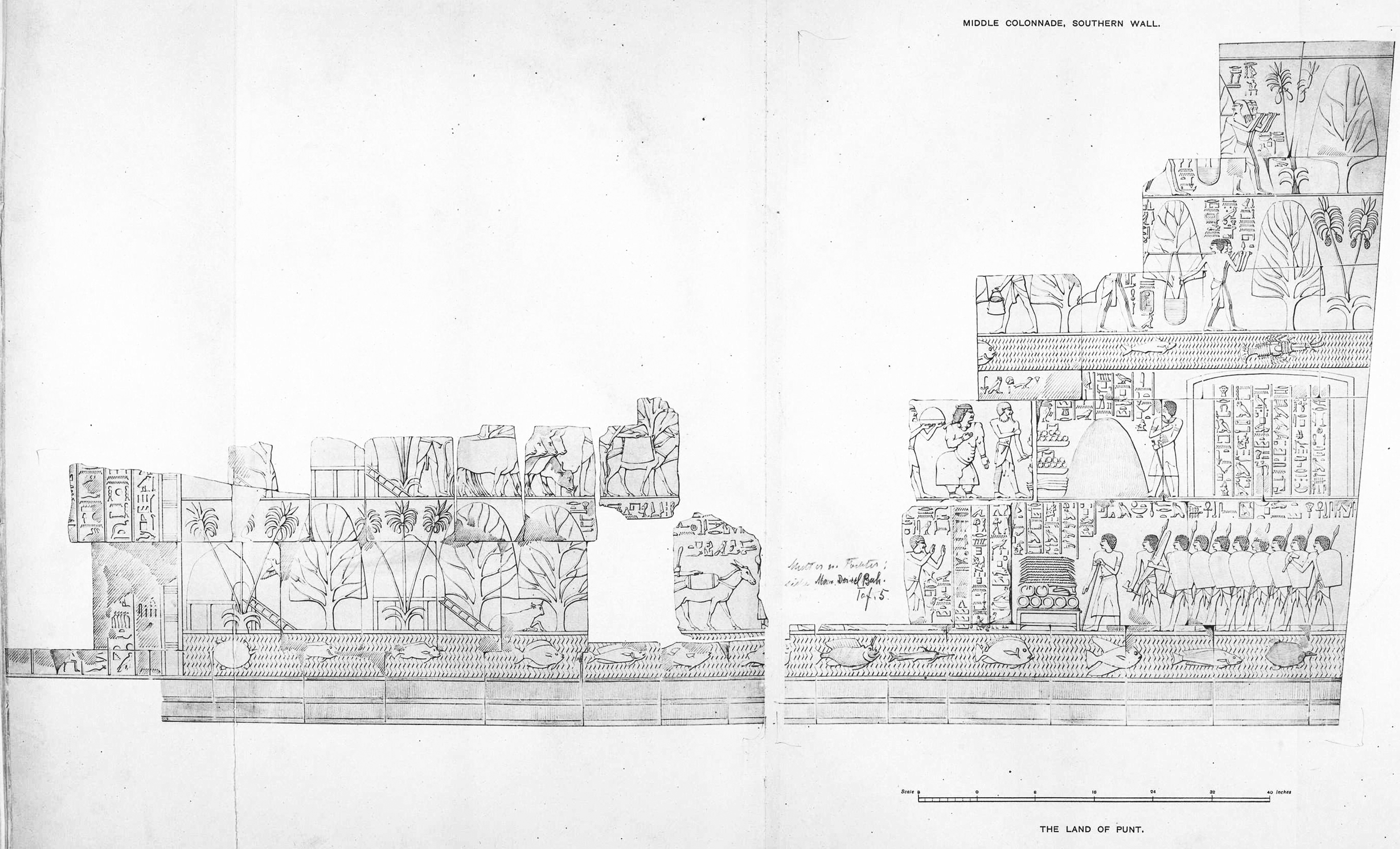
Figure 6. The Land of Punt (Eduard Naville, 1898)
The picture of the Land of Punt was divided into four rows. In two of them the separation is made by a line of water in which fishes and tortoises are swimming. What is seen above the water may be considered as taking-place in the immediate vicinity of the shore, whereas where there is a simple line under the figures they are meant to be further inland.
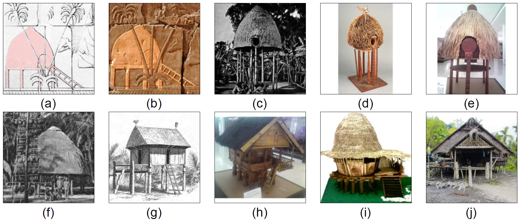
On the shore we find the huts of the people; they are built on poles, with ladders giving access to them, evidently in order to protect the inmates against wild animals. These huts are made of wickerwork, probably of palm-stalks; they are all of the same shape and construction. They stand under the shade of palms, and of other trees having a conventional form, which, judging from the inscriptions, may signify incense and ebony trees. Near the huts they are certainly ebony trees, the branches of which are cut down by the Egyptians “in great quantities”, and which are high enough for the cattle to rest under their shade.
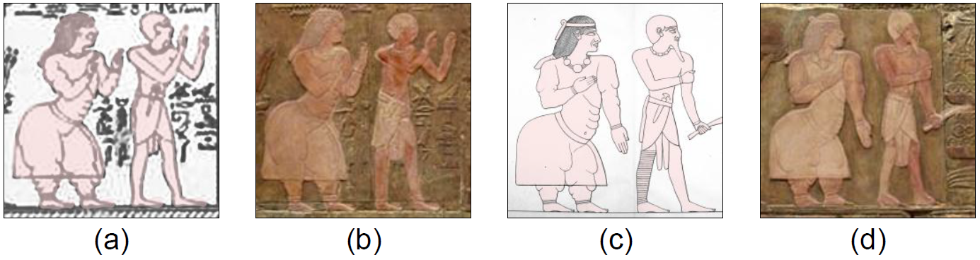
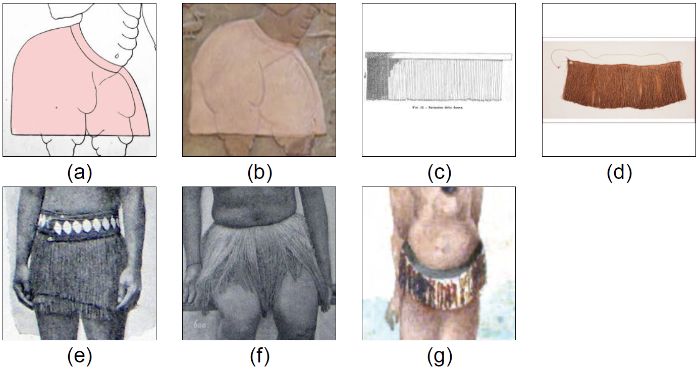
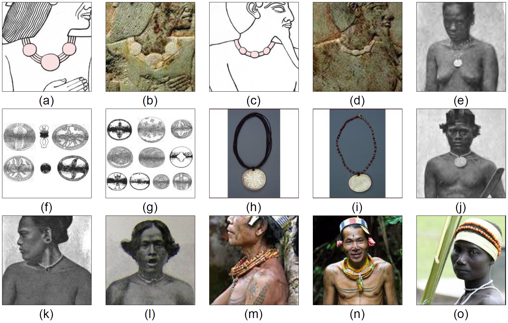
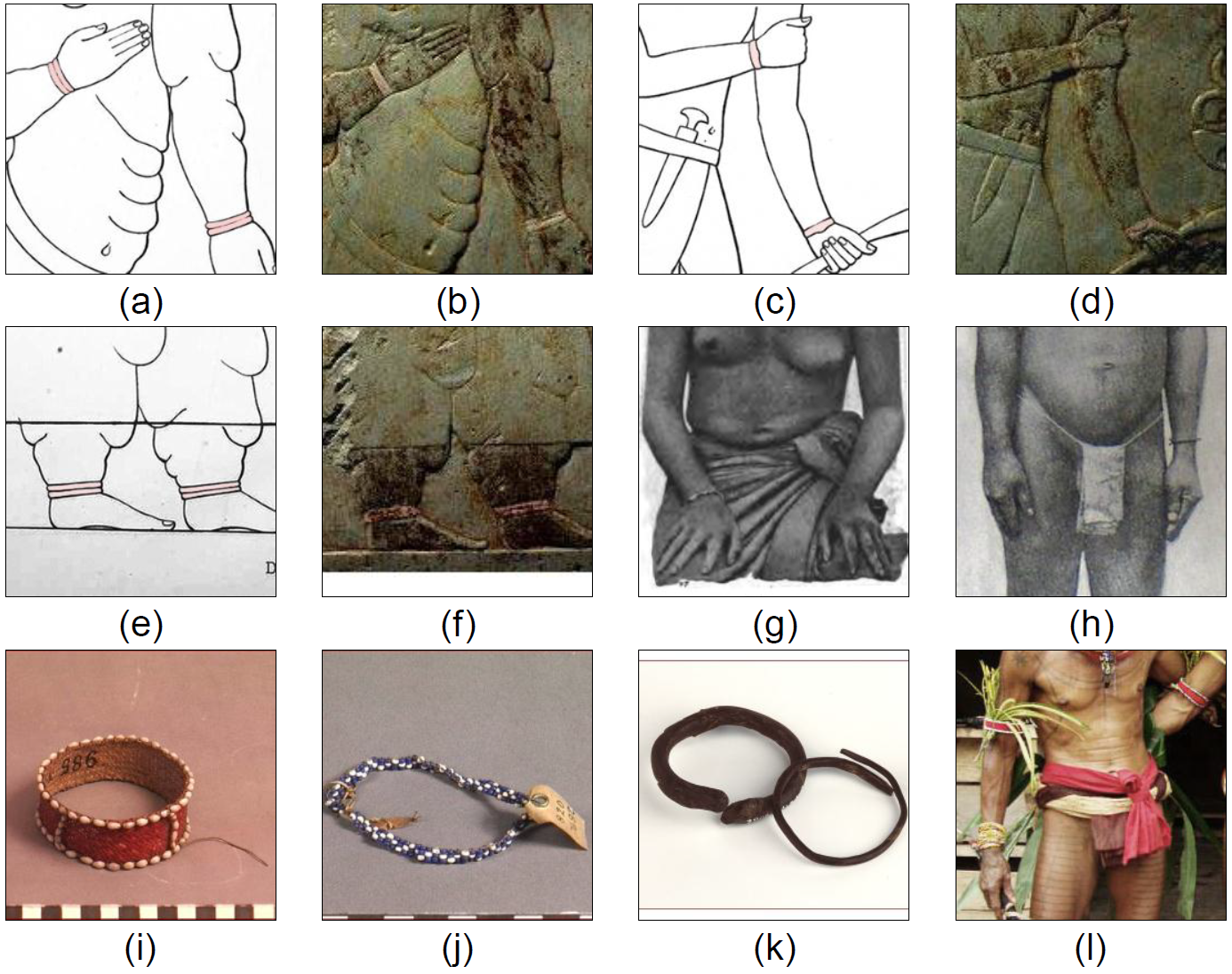
The Puntite, unlike ancient Egyptians, had longer hair and little facial hair. The Puntite is a tall, well-shaped man, his hair is brighter; his nose is straight, his beard long and pointed grows on his chain only; he wears only a loincloth with a belt in which a dagger is fixed. The inscription engraved in front of his body states that he is “The Great of Punt, Parehu”. The left leg of the chief, Parehu, is covered with a bracing of rings. In one scene, his left hand holds a curved weapon. The Puntites are painted red, but not as dark as the Egyptians. He is followed by his wife, his two sons, and his daughter, to each of whom is attached a short inscription. The two youths are simply described as “his sons”, and the young girl as “his daughter”. His spouse, a very singular and unbeautiful person, is described as “his wife, Ati”. She wears a yellow dress, bracelets on her wrists, anklets on her ankles, and a necklace of alternate bead and chain work round her throat. Her hair, like that of her daughter, is bound with a headband on the brow. Her features are repulsive, and her cheek is disfigured by facial wrinkles. She is hideously obese, her limbs and body being weighed down by rolls of skin. Her daughter, though evidently quite young, already shows a tendency towards the same kind of deformity. The complexions of the whole family are painted of a light red, and their hair black, thus showing that they are not of negro race. The superimposed hieroglyphic inscription, which extends to some length beyond that of the illustration, states that “Hither come the Great [ones] of Punt, their backs bent, their heads bowed, to receive the soldiers of His Majesty”.
An ass, saddled with a thick cushion, and three attendants carrying short staves, bring up the rear of the procession. Over the ears of this beast of heavy burden is engraved in hieroglyphic characters, “The great ass that carries his wife”. The men who guide and follow the ass wear the upcurved-beard everywhere characteristic of the natives of Punt in Egyptian art.
On the shore Hatshepsut’s royal envoy having landed, accompanied by his military escort, arranges on a table, or stand, the gifts which he has brought for presentation to the Prince of Punt. The envoy is in civil dress, and leans upon his staff of command. The soldiers are armed with spear and hatchet, and carry a large shield rounded at the top – the ordinary equipment of infantry of the line. Their captain carries no shield, but is armed with a bow, in addition to the spear and hatchet of his followers. We know from another inscription the name of this messenger: “he is called Nehsi”, the negro. His mission is quite peaceful. On a small table he has placed the presents offered by the queen, which are not of great value: necklaces, probably made of blue porcelain beads, an axe, a dagger and a few bracelets. The text above the table reads:
“The landing of the royal messenger in the Divine Land, with the soldiers who accompany him, in presence of the chiefs of Punt, to bring all good things from the sovereign (life, strength and health) to Hathor, the lady of Punt, in order that she may grant life strength and health to Her Majesty.”
This is a circuitous manner of stating that the said good things are intended, not for the goddess, but as a means of exchange for the coveted products of Punt.
Parehu seems afraid; he is raising his hands towards the Egyptians.
“The coming of the chiefs of Punt, bowing and stooping in order to receive these soldiers; they give praise to …… Amon (probably put there instead of the queen).”
Behind Parehu stood his wife, Ati, two sons and his daughter, as may be seen from Mariette’s publication. But this most valuable block has unfortunately disappeared, as well as the text it contained, which expressed the astonishment of the Puntites at the sight of the strangers. Naville gave a translation of their words as reproduced by Mariette: “They say in asking for peace: you arrived here on what way, to this land which the Egyptians did not know? Have you come through the ways of the sky, or have you travelled on water to the green land, the divine land to which Ra has transported you? For the king of Egypt there is no closed way, we live of the breath which he gives us.”
From what we see on the upper row the intercourse between the messenger and the Puntites soon becomes cordial. While the Egyptian sailors, assisted by the natives of Punt, are busily engaged in loading the ships, Hatshepsut’s envoy offers an official reception to Parehu, his wife and family. This parting interview is conducted with great ceremony on both sides. A tent has been pitched by order of the messenger, before which Parehu and his family, “the chiefs of Punt”, appear again.
“the coming of the chief of Punt, bringing his goods on the shore in presence of the royal messenger.”
The Lady Ati is appareled as before, but the right leg of Parehu is covered from the ankle to above the knee with a close succession of metal rings. The objects which are brought, and which are called tributes, are properly goods to be exchanged against the products of Egypt; they consist of gold in rings, a heap of curved weapons, the same weapon which Parehu has in his hand, and a big heap of the famous incense called ảnti, of which there were several varieties, and of which the Egyptians made such great use that the procuring of it was the main reason which induced them to send expeditions to Punt. The sons of Parehu, one of them carrying a bowl of gold-dust; an attendant bearing a large jar on his shoulder; and the ass, which has again enjoyed the unenviable privilege of carrying the Lady Ati, bring up the rear. The pile of ảnti is here represented in a very summary fashion by a mere outline, but in some of the other subjects the little irregularly shaped lumps of the precious gum are all elaborately defined. The envoy stands in front of his pavilion – omitted in the illustration – and is apparently in the act of inviting his guests to partake of the banquet which, by order of Hatshepsut, he has prepared for them.
The messenger is said to receive these things, but his queen has ordered him to be generous, and to show something of her royal hospitality. Nehsi will entertain the chiefs of Punt to a banquet in his tent.
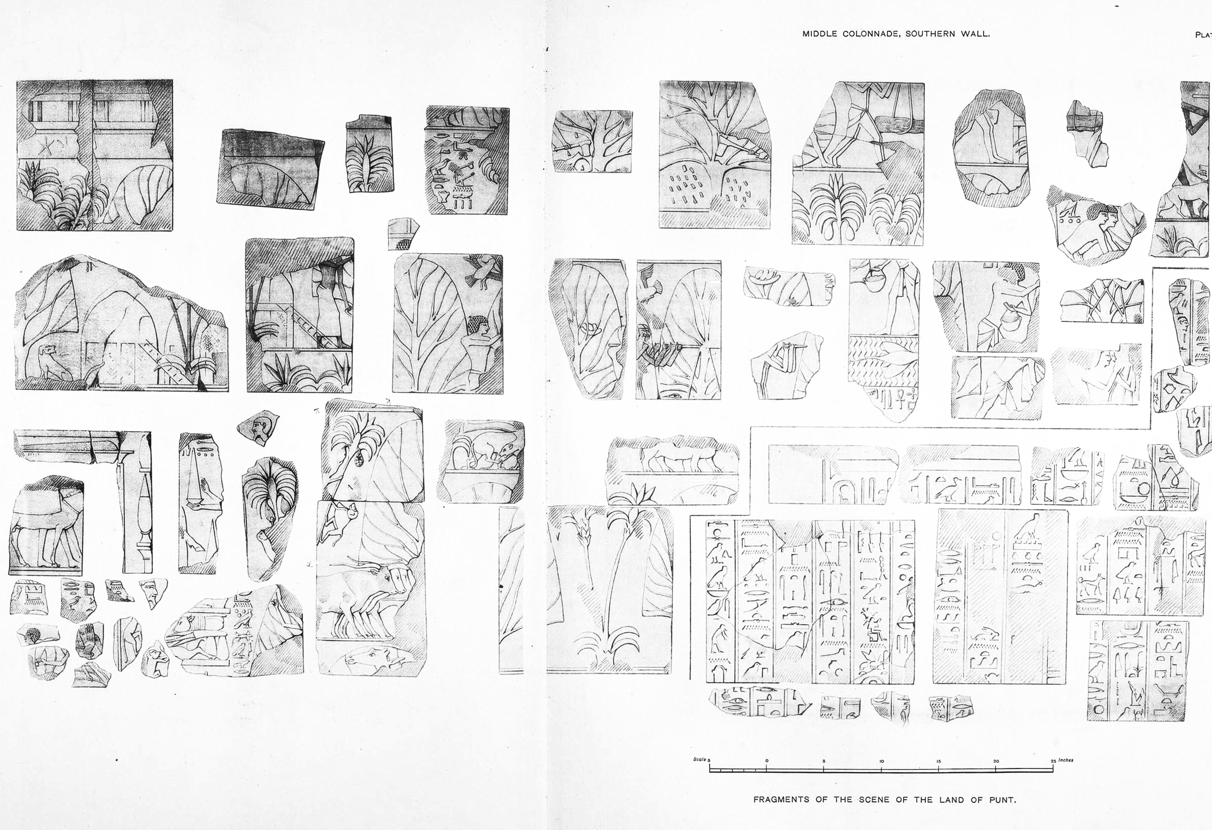
Figure 7. Fragments of the scene of the Land of Punt (Eduard Naville, 1898)
The considerable part of this wall which is lost contained very interesting scenes, of which fragments only have been recovered. There could be seen the huts of the negroes with the big dog crouching at the door; the Egyptians felling branches of ebony-trees, “cutting ebony in great quantity”, the wood being carried to the ships by the negroes, who brought also their dogs, which may have been used in Egypt for the chase of the antelope and the wild bull. In the ebony trees, under the shade of which the huts are built, birds have made their nests and laid eggs, which are being taken away by the Egyptians. It is difficult to recognize what birds they are, owing to the incorrectness of the proportions. The Egyptians were seen also taking the eggs from the nests of the birds. The places where the fragments were found would make us think that this wall was ruined before the occupation of the temple by the Copts.
A small fragment, the top of which is destroyed, shows the lower part of an animal which looks like a rhinoceros.
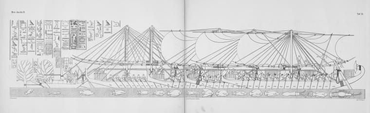
Figure 8. Loading Egyptian boats in Punt (Eduard Naville, 1898)
The various scenes on this wall are not arranged with the same regularity as on the other side of the colonnade. They sometimes occupy the whole height of the wall, as for instance the description of the Land of Punt, or they are put one over the other, as is the case here. In the very interesting subject now before us, we see the Egyptian sailors, some carrying the saplings in baskets slung from poles, as before; others laden with big jars; and all hurrying on board along inclined planks reaching presumably from the shore, which, however, is not shown in the picture. The decks are already piled high with their precious cargo, among which may be observed three macaques, who make themselves perfectly at home. Slung to the main-mast of the nearest vessel, a harp is depicted, of a shape which may even now be seen in the hands of native musicians in Cairo and other large towns. The captain stands on the platform at the prow, issuing his commands; and, small as is the scale, the very natural action of the man in front of him, who shouts the order with his hand to his mouth, must not be overlooked. Some more are being brought by the sailors. The loading is described as follows:
“The loading of the cargo-boats with great quantities of marvels of the land of Punt, with all the good woods of the divine land, heaps of gum of ảnti, and trees of green ảnti, with ebony, with pure ivory, with green nub of ảamu, with cinnamon wood, khesit wood, balsam, soter-incense, mesṭemtu, with ảnảu, monkeys, dogs, and with skins of leopards of the south, with inhabitants of the country and their children. Never were brought such things to any king, since the world was.”
While these last two vessels are receiving their cargoes, the other three have already weighed anchor, and are seen with their sails set and filled by a favorable wind. A short inscription states that this is “the peaceful and prosperous voyage of the soldiers of his Majesty returning to Thebes, bringing with them the men of Punt. They bring such marvels of the Land of Punt as have never been brought by any King of Egypt, on account of the greatness of the King of the Gods, Amon, Lord of Thebes”.
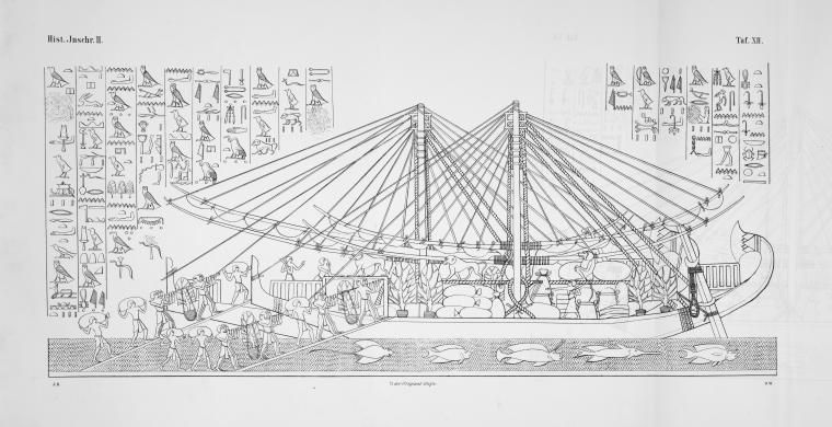
From this point, the sculptured posterities form a continuous scene, those in the lower register being almost perfect, whereas those in the upper register are unfortunately so much broken away that in many places there remain only the feet of the figures and the water lines of the river. In several of the best preserved, we see the Egyptian sailors carrying half-grown saplings which have been taken up with a ball of earth about the roots, and are being transported in baskets slung upon poles, each pole carried by four men. These, as they wend their way towards the ships, are accompanied by natives of Punt. In one place where there is a great gap in the wall, the remains of the inscription show that an elephant and a horse were among the animals embarked from Punt for the gratification of Hatshepsut. A running commentary of short inscriptions is interspersed here and there between the figures. “Stand steady on your legs, Bohu!” says one of the bearers. “You throw too much weight upon my shoulders”, retorts Bohu.
Over the saplings which are being carried in baskets, is inscribed nehet ảnti; that is to say, the sycamore of ảnti. Elsewhere we see the full-grown trees. The trunk is massive; the leaf is a sharp-pointed oval; and at the junction of the trunk and the larger branches are seen little copper-colored lumps of irregular form, representing the resinous gum which has exuded through the bark.
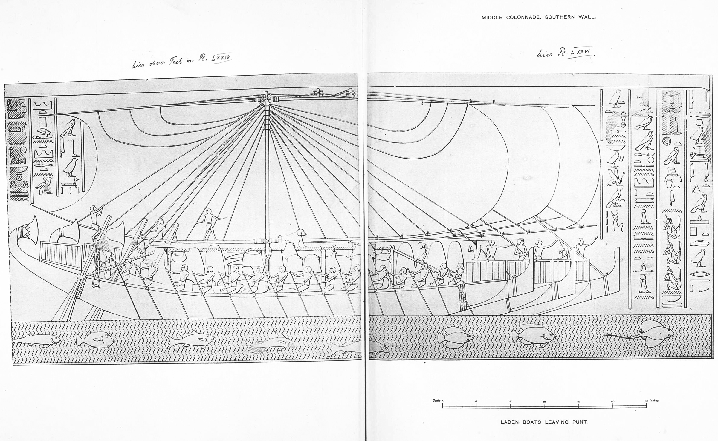
Figure 9. Laden boats leaving Punt (Eduard Naville, 1898)
The next scene describes the voyage back to Egypt, and the happy arrival of the expedition at Thebes.
“The navigation, the arrival in peace, the landing at Thebes with joy by the soldiers of the king; with them are the chiefs of this land, they bring such things as never were brought to any king, in products of the land of Punt, through the great power of this venerable god Amon Ra, the lord of the thrones of the two lands.”
The return voyage, like the outward voyage, is passed over; and the next incidents of this curious panorama in stone take place in Thebes. We are shown nothing of the arrival of the squadron, nor of the unlading of the ships; the rest of the posterities consisting mainly of processions of priests, soldiers, and sailors. The order in which these processions meet and succeed each other is somewhat confusing. The hieroglyphic inscriptions in this part of the building are also greatly mutilated, so that the subjects in many instances have to be taken as their own interpreters. It seems possible that they do not all represent the return of the expedition from Punt, but that some may have reference to the ceremonies which accompanied the opening of the temple. The unity of the composition as an historic whole is moreover impaired by the introduction of other foreign tributaries besides those brought from Punt; whence it may be concluded that the artist, in order to produce a more brilliant effect, introduced the representatives of various nations who on other occasions, had laid their tribute at the feet of Hatshepsut.
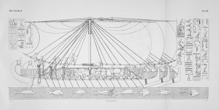
Figure 10. Chiefs of Punt bowing before Egyptians (Eduard Naville, 1898)
Figure 8 and Figure 10, which is to be placed over Figure 9, shows us the landing from the ships at Thebes in the presence of the queen. This representation, of which nearly all the upper part has been lost, is particularly interesting, because we see Africans in great number who have come to Egypt with the ships.
Beginning at the end of the long train which marches towards the queen, we see Puntites carrying ebony, curved weapons, and driving cows. Before them are Egyptians bringing the precious incense-trees. Next come two rows of men, each row being divided in two at the beginning. In the lower one we find again Puntites with amphoras, probably filled with balsam, and baskets containing ảnti. One of them leads a macaque. The long pointed loaves and the obelisks are resin to which that shape has been given. In front of the procession of Puntites are four chiefs kneeling, with hands raised towards the queen, and imploring her to be merciful to them.
“they say, imploring her Majesty, hail to thee, King of Egypt, Lady Ra, shining like the solar disk ……”
The Puntites have the same type and dress as we saw in the description of their country. Above them are the chiefs of “the Irem”. As far as we can judge from what is left of the head of the kneeling chief and from the standing man who follows bringing gold and a leopard or a panther, and who may be one of them, the Irem are not negroes. Above are two negroes, called the chiefs “of Nemyuw”; these men are the same as those seen near the huts. The block on which they are represented was recovered in pulling down one of the upper walls.
According to Brugsch, the Irem are the Blemmyes. Like the Egyptians, they belong to the Hamitic branch; they bring gold and a leopard or a panther.
In the eighth year of Seti I (1283 BC), Irem revolted. However, the campaign against Irem was far less serious than any one of Seti’s Levantine campaigns. Seti I, setting off from the Nile, managed to take five wells and 400 people with the use of chariots. The importance of wells and the use of chariots (not boats, as might be expected for a place inside the Nile Valley) suggest that Irem was a pastoral area outside the Nile Valley. This location of Irem makes its identification with the Yam of the Old Kingdom all the more likely.
Since Nemyew’s chiefs are portrayed as negroes, it should be placed somewhere in the Nile valley above Kurgus.
All these men are supposed to be in presence of the queen, who, however, does not seem to have been herself represented. On a kind of stand adorned like a throne was her cartouche and her ka name. The text which was next to it is destroyed to nearly half of its height.
“…… the bowing down before Usertkau (Hatshepsu) by the chiefs of Punt
…… the Ảnti of Nubia of khenthunnefer, all lands………… of
…… stooping, bringing their goods in the place where is her Majesty.
…… roads which never had been trodden by others; it was reckoned
…… the lord of Thebes, as a tribute for each year.
…… as was ordered to her by her father, who put all lands under her feet living eternally.”
Nubia is a region along the Nile river located in what is today northern Sudan and southern Egypt. The name Nubia is derived from that of the Noba people, nomads who settled the area in the 4th century, with the collapse of the kingdom of Meroë. Before the 4th century, and throughout classical antiquity, Nubia was known as Kush, or Khent Hunnefer, or Khent-hen-nefer, or Khenthennofer, or, in Classical Greek usage, included under the name Ethiopia (Aithiopia). Nubia had a great influence on Egypt. Even the way the Nubians wore their hair was copied by the Egyptians.
Figure 11. The queen offering to Amon the products of the expedition (Eduard Naville, 1898)
In order to express her thankfulness to Amon, who had shown the way to her ships and brought them back safely, Hatshepsu must consecrate the best things of Punt to the god. This we see her doing in a scene which occupies the whole height of the wall. Hatshepsu standing, wearing the atef crown, holding the insignia of royal power, and followed by her ka, dedicates to Amon the choice products of the foreign countries.
“The king himself, king of Upper and Lower Egypt, Ramaka takes the good things of Punt, and the valuables of the Divine Land, presenting the gifts of the southern countries, the tributes of the vile Kusch, the boxes (of gold and precious stones) of the land of the negroes to Amon Ra, the lord of the throne of the two lands. The king Ramaka, she is living, she lasts, she is full of joy, she rules over the land like Ra eternally.”
Figure 12. Incense trees planted in the Garden of Amon (Eduard Naville, 1898)
The valuable cargo which the queen feels bound to offer to Amon is represented in the four following figures. The wall is here divided into two rows. Beginning at the bottom, we see first the products which are properly those of the Land of Punt, four large trees, incense-trees planted in the garden of Amon, where they have prospered and reached such a height that cattle may easily walk under their branches. Various things have been collected in the shade of the trees: ảbu, which means ivory. Under the tusks is a substance called kash, the meaning of which is doubtful, but Naville considers being tortoise-shell judging from the determinative.
The cattle are the short-horned cows, further we see ebony, bags of the substance called mesṭem (Naville and Mariette allege as antimony, used for dyeing the eyes), then the curved weapons similar to the one held by Parehu (the ảamu of the Puntites), and rings and boxes full of the metal åsem (Naville assumes as an alloy of gold and silver).
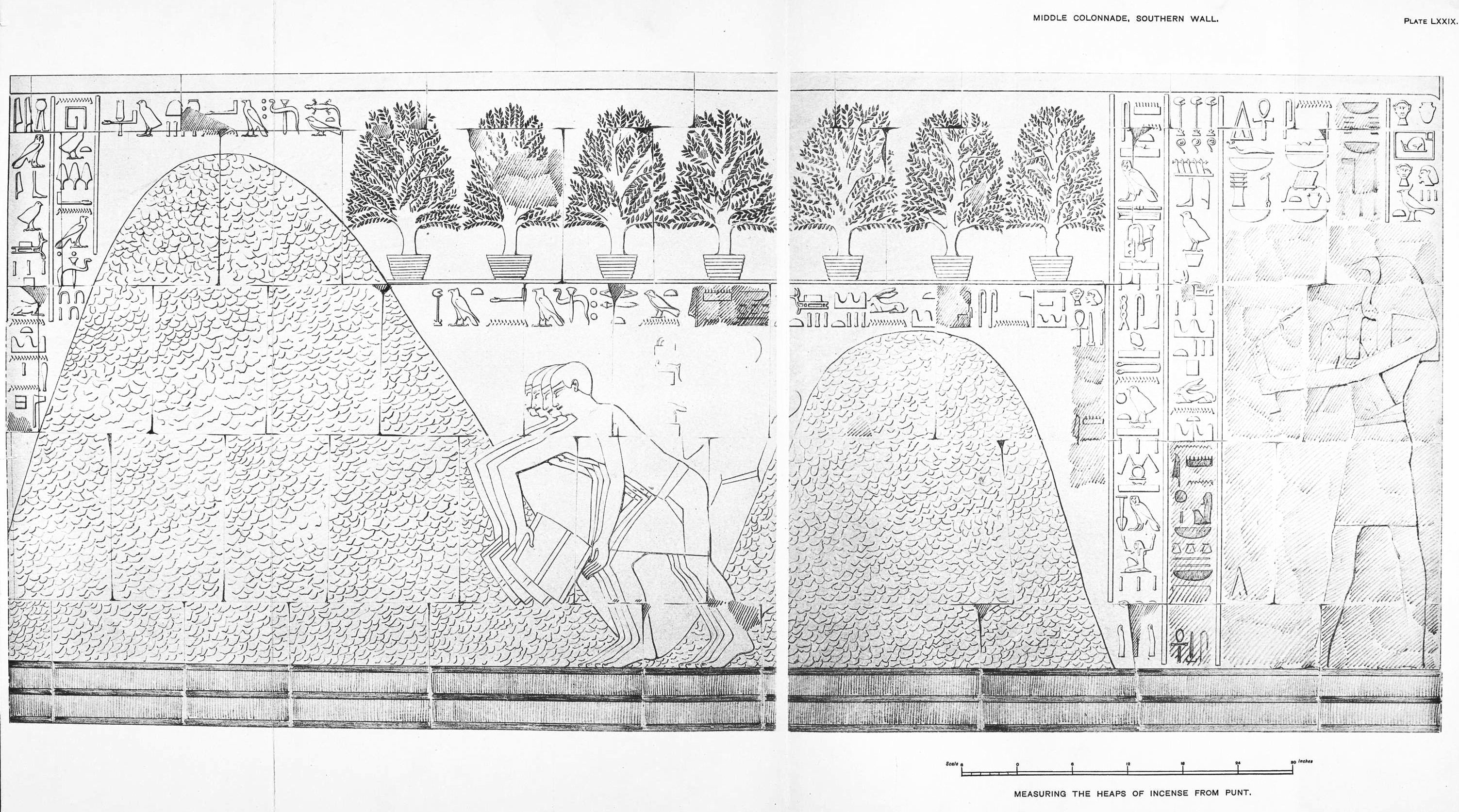
Figure 13. Measuring the heaps of incense from Punt (Eduard Naville, 1898)
The incense ảnti, of which there were as many as fourteen different sorts, was the most important product of Punt. We see here that the numerous bags of that substance which were the chief part of the cargo of the ships, have been emptied, and the incense, after having been measured by means of bushels, is gathered in large heaps. The text explains that “these are heaps of green [fresh] ảnti in great number; the measuring of green ảnti in great quantity to Amon, the lord of the thrones of the two lands, from the marvels of the Land of Punt, and the good things of the Divine Land”. Above the heaps are incense-trees in pots. “Trees of green ảnti thirty-one, brought among the marvels of Punt to the Majesty of this god, Amon Ra, the lord of the throne of the two lands; never was such thing seen since the world was.”
Behind the four men emptying their bushels stood a man whose figure has been rubbed off. He is called “the writer, the steward Thoth[mes?]”. We do not know why his figure has been erased; he may have been one of the friends and supporters of Hatshepsu, and therefore his name and figure were destroyed. We shall see other instances of names of officials being erased.
The god Thoth himself acts as writer, and keeps a record of all that has been brought from Punt and offered to the god:
“to record in writing, to make up the accounts; altogether millions, hundreds of thousands, tens of thousands, thousands, hundreds [an infinite number] of good things of the Land of Punt, given to Amon Ra.”
Thoth, who is said to reside in a temple, the name of which is doubtful, and who is called the chief of the rekhytu, has been erased. This destruction is certainly not the work of any of the Thothmes, and must be assigned to a later date.
Figure 14. Products of the southern lands (Eduard Naville, 1898)
Above the products of Punt are those which are supposed to come from the southern countries (Upper Nile), viz the regions of the Upper Nile, inhabited by the negroes whom we saw represented before, and by the Anti of Nubia. These goods must have been brought by caravans, showing that there was already a regular trade established between the valley of the Nile and the coast. We see here a giraffe, long-horned cattle, two kinds of leopards: the larger which seems to have been only an object of curiosity, while the others are held by collars, and were probably more or less tame, so as to be used for hunting. As in the case of Punt we see great quantities of åsem, in rings and boxes, curved weapons and ebony, besides skins of leopards, bows, feathers, and ostrich eggs.
Above the large gap in the middle of the figure we see the tops of several columns of text and fragments of a cartouche which seems to be that of Thothmes I. It probably refers to his campaign in Asia, towards the Euphrates, as far as a place called Niy, where Thothmes III, his grandson, as we know from the biography of one of his officials, hunted elephants, killing a great number of them. The few signs • left point to an inscription of the same kind as that which relates the deeds of the younger king.
Figure 15. Weighing precious metals from the southern countries (Eduard Naville, 1898)
All the good things from the southern countries are brought to Amon by the god Tetun, the god of Nubia, who is present at the weighing of the precious metals. This weighing is superintended by Horus:
“The balance, the right one of Thoth, for weighing silver, gold, lapis lazuli, malachite.”
On the sculpture there is only the weighing of åsem in rings; below are the weights ṭebennu, some of which have the form of bulls. As Thoth did in the case of Punt, Safekhabui here records an unlimited number of good things from the lands of the south.
The debate over Punt’s place on the map began in the 1850s, when the newly formed Antiquities Service of Egypt began clearing the great temples in and around Thebes. Based on newly revealed hieroglyphic texts that described Punt as a source of aromatic substances situated to the east of Egypt, Heinrich Karl Brugsch first suggested, in the late 1850s, that Punt lay on the Arabian Peninsula. It seemed straightforward enough. After all, the Greeks had glorified the “perfumes of Arabia”, a land that lies due east of Egypt.
Auguste Mariette changed this thinking with two discoveries. One was a hieroglyphic list that the Pharaoh Tuthmosis III left at Karnak Temple in Thebes that included Punt in those lands south of Egypt. The other was Hatshepsut’s bas-relief, which, among other evidence it bears that points to Africa, shows distinctly African animals as products or natives of Punt, including the giraffe and rhinoceros, neither of which is found in Arabia. For the location of Punt, Mariette settled on the Somali coast, which also is known for its aromatics, including the fabled incense.
Mariette’s hypothesis held well into the next century. Then, in the 1960s, based on a detailed study of the flora and fauna and other elements of Punt represented in Hatshepsut’s bas-relief, Rolf Herzog placed Punt along the Upper Nile south of Egypt, specifically between the Atbara River and the confluence of the White and Blue Niles. Punt, Herzog felt, was reached overland and by river, but not by sea.
Yet Hatshepsut’s relief appears to contradict that stance, as Kenneth Kitchen pointed out in a 1971 review of Herzog’s work. Most indisputably, Kitchen notes, the fish that Hatshepsut’s carvers depicted beneath the Punt ships, along with other marine creatures such as spiny lobster and squid, are clearly recognizable as species that swim to this day in the Red Sea.
Kitchen, in nearly four decades of writing on the subject of Punt, has succeeded in establishing what today is the most widely accepted position on the location of Punt. It was situated, he proposes, in what is today eastern Sudan and northern Ethiopia, extending from the Red Sea to the Nile. Arabia was out of the question, Kitchen says. Perhaps the most contrary evidence is linguistic, he writes: “As for Parehu, the only named chief of Punt, the consonant p in his name and that of Punt itself also firmly excludes Arabia”. Old South Arabian languages possess an f but no p. Thus, Kitchen writes, “Arabia would have had a Farehu, chief of Funt”! Egyptian has both consonants, so the transcription is reliable, he adds.
Other experts, while acknowledging the p problem, are not so quick to dismiss Arabia as the Land of Punt. In a 2003 paper – one that Kitchen himself called “a brilliant, most impressive tour de force” even as he challenged its premise – Dmitri Meeks advanced the notion that Punt lay along the entire western coast of the Arabian Peninsula, from the Gulf of Aqaba to Yemen. Meeks says that when one takes all ancient references to Punt into account, the picture becomes clear. “Punt, we are told by the Egyptians, is situated – in relation to the Nile Valley – both to the north, in contact with the countries of the Near East of the Mediterranean area, and also to the east or southeast, while its furthest borders are far away to the south”, he writes. “Only the Arabian Peninsula satisfies all these indications.”
In one of the most recently proposed hypotheses, Stanley Balanda, in a 2005 – 2006 paper, offers a sort of compromise between the Kitchen and Meeks theories. Balanda argues that a key expression within Hatshepsut’s text has been misinterpreted as saying “by the sea” or “along the sea front” when it really means “on both sides of the sea”. If Hatshepsut’s expeditionaries had indeed, as Balanda translates one bit of hieroglyphs, “pitched tents for the king’s representative and his expedition to the incense terraces on both sides of the sea in order to receive the chiefs of this land”, then one place on the Red Sea presents itself above all others. This is the straits of Bab el Mandeb at the sea’s southern end, where today Djibouti and Yemen face each other across narrows no wider than the English Channel. Punt, Balanda proposes, was a region of indeterminate size stretching out on both sides of the strait, which lay at the heart of Puntite commercial activities.
The most famous Egyptian expedition to Punt, and the one from which we derive most of our information is the one conducted by 18th-dynasty Queen Hatshepsut (1473 – 1458 BC) and recorded in the splendidly detailed reliefs on the walls of her mortuary temple at Deir El-Bahari. This expedition was led by the Nubian officer, Nehsi. The route “by land and sea” most probably went from Koptos overland via Wadi Hammamat to the Red Sea port of Queisir, the dismantled five ships being transported by donkey to be re-assembled on arrival at the port (Kitchen 1993). The text accompanying the Deir el-Bahari reliefs specifically repeats three times that the expedition went “by land and sea” and this same method of travel was used on the expedition led by Henu in the reign of king Mentuhotep III and on the expedition mounted by king Ramesses III. The expedition of Senusret I provides some of the clearest evidence of a major Egyptian expedition to Punt using the Red Sea route.
Papyrus Harris I, a contemporary Egyptian document which detailed events that occurred in the reign of the early 20th dynasty king Ramesses III, includes an explicit description of an Egyptian expedition’s return from Punt:
“I hewed great galleys with barges before them. They were sent forth into the great sea of the inverted water, they arrived at the countries of Punt. They were laden with the products of God’s Land.They arrived safely at the desert-country of Coptos: they moored in peace, carrying the goods they had brought. They [the goods] were loaded, in travelling overland, upon asses and upon men, being reloaded into vessels at the harbor of Coptos. They [the goods and the Puntites] were sent forward downstream, arriving in festivity, bringing tribute into the royal presence.”
Sayed in the mid-1970s found potsherds with painted (hieratic) inscriptions and inscribed stelae recording expeditions to Bia-Punt (the “mine” of Punt), some carved, round-topped anchors and a fragment of carved cedar timber with a mortise, most likely from a ship. He suggested that Mersa/Wadi Gawasis was the pharaonic port of Sʒww for seafaring expeditions to Punt in the Twelfth Dynasty. Bard and Fattovich in 2001 revealed ceremonial structures, ship timbers, stone anchors, ropes, and other artifacts dating to early and later Twelfth Dynasty. They also uncovered carbonized ebony woods and obsidian (a volcanic glass), as well as blades of a steering oar. They even found cargo boxes bearing painted hieroglyphic text describing the contents as the “wonderful things of Punt”.
Such clear evidence for a sea route to Punt is practically irrefutable, and it is now generally accepted by most scholars that some if not most expeditions used the Red Sea to travel to Punt. The attribution of Punt as “Land of the Gods”, “Land of the Ancestors”, “Holy Land” or “Divine Land” referred to as the Abode of the Gods where its location is to the east of Egypt in the direction of the sunrise, means that Punt definitely located east of Egypt. The expeditions to travel to Punt used the sea route began at the Red Sea.
The Egyptians were not particularly well versed in the hazards of sea travel, and the long voyage to Punt is a situation involving exposure to danger. The rewards of obtaining incense, ebony and other valuable goods clearly outweighed the risks.
The expedition to Punt by Hatshepsut is recorded in the splendidly detailed reliefs on the walls of her glorious mortuary temple at Deir El-Bahari. Her reputation and magnified accomplishment achieved by the successful return upon the dangers of the sea, ritual and celebration after the achievement and the indicator of her leadership and skill in motivating and governing the Egyptian society to high achievement, exhibit how difficult the voyages leading to and returning from Punt was. Such things were also accomplished by the former and following pharaohs, though not well documented. These complications and achievements would indicate that the voyages did not take place solely in the Red Sea, but in the open sea, the Indian Ocean. The very long distance would explain why so few voyages were made there, unlikely in the Red Sea alone. The inscription on the wall of Deir El-Bahari “traversing the Great Sea on the Good Way to the Land of the Gods” and from Papyrus Harris I “They were sent forth into the great sea of the inverted water…” depict the route was an ocean (“Great Sea”).
The colonnade reliefs at Deir El-Bahari are clearly of crucial importance since they show in great detail its flora and fauna and its inhabitants. The scenes illustrate not only the trade products which the Puntites traded with the Egyptians but also some of the fauna and flora of Punt. The former may be classed as luxury goods of which the most important is incense (ảnti), used widely in Egyptian religious ritual worship. Other goods include ebony, ivory, gold/electrum, cinnamon wood, khesit wood, balsam, resin, tortoise shells and weapons. The fauna depicted include such diverse species as short-horned cows, pig-tailed macaques, one-horned rhinoceros, monkeys, dogs, skins of clouded leopards and a wide variety of fishes are also displayed. The floras have been identified as the betel palm, the ebony tree and the styrax tree. The huts of the people are built on poles, with ladders giving access to them, made of wickerwork of the same shape and construction.
Archaeological evidence is so far somewhat sparse and unless additional evidence turns up, it is unlikely that anyone will ever be able to pinpoint the location of Punt with total certainty. All that one can do is make a hypothesis for its whereabouts with a fair degree of probability, by gathering evidence shaping a compound of observable characteristics (term similar to “phenotypes” in biology). The evidence shall be of genuine proofs strongly or most probably representing the phenotypes. The richer the compound of the phenotypes, the stronger the likelihood of the hypothesis. Relying on this method and after gathering evidence, the author makes a hypothesis that the Land of Punt is located in Sumatera, Indonesia.
Sumatera is an island in western Indonesia, the largest island that is entirely in Indonesia (two larger islands, Kalimantan and Papua, are shared between Indonesia and other countries) and the sixth largest island in the world. The Indian Ocean borders the west, northwest, and southwest sides of it with the island chain “Barrier Islands” of Simeulue, Nias, Mentawai, Pagai and Enggano bordering the southwestern coast. On the northeast side the narrow Strait of Malaka separates the island from the Malay Peninsula, an extension of the Eurasian continent. On the southeast the narrow Sunda Strait separates it from Java. The northern tip borders the Andaman Islands, while on the eastern side are the islands of Bangka and Belitung, Karimata Strait and the Java Sea.
Sumatera was known in ancient times by the Sanskrit names of Swarnadwīpa (“Island of Gold”) and Swarnabhūmi (“Land of Gold”), because of the gold deposits of the island’s highland. Arab geographers referred to the island as Lamri (Lamuri, Lambri or Ramni) in the 10th to 13th centuries, in reference to a kingdom near modern-day Banda Aceh which was the first landfall for traders. Late in the 14th century the name Sumatera became popular in reference to the kingdom of Samudra Pasai, which was a rising power until it was replaced by Sultanate of Aceh. Sultan Alauddin Shah of Aceh, on letters written in 1602 addressed to Queen Elizabeth I of England, referred to himself as “king of Aceh and Samudra”. The word itself is from Sanskrit samudra, meaning “gathering together of waters, sea or ocean”.
Odoric of Pardenone in the story of his voyage in 1318 mentioned that he sailed to the east of the Coromandel, India, for 20 days, and came to the kingdom Sumoltra. Ibn Bathutah told in the book of Rihlah ila l-Masyriq (“Wandering to the East”) that in 1345 he was stopped in the kingdom of Samatrah. In the following century, the name of Samudra, a kingdom in Aceh, was taken by travelers to mention the whole island. European writers in the 19th century found that the indigenous inhabitants did not have a name for the island.
Many travelers including Ibn Majid, Roteiro, Amerigo Vespucci, Masser, Ruy d’Araujo, Alfonso Albuquerque and Antonio Pigafetta recorded the names: Samatrah, Camatarra, Samatara, Samatra, Camatra, Camatora, Somatra, Samoterra, Samotra, Sumotra, Zamatra and Zamatora. Records of the Dutch and English colonials, since Jan Huygen van Linschoten and Sir Francis Drake in the 16th century, have always been consistent in the writing of Sumatra (Indonesian Sumatera).
Sumatera is the cradle of Malay civilization. A name Bhumi Malayu, written in the Padang Roco Inscription dated 1286 and 1347 CE found in Dharmasraya (central Sumatera), Adityawarman declared himself as the ruler of Malayupura. The Majapahit record, Nagarakretagama dated 1365 CE, mentioned that the land of Melayu was dominated by Majapahit Empire. From these records, the name Malayu seems to be identified with the area around the Batanghari valley from estuarine to hinterland in present-day central-eastern of Sumatera. The people inhabiting the eastern coast of Sumatera and parts of the Malay peninsula identified themselves as Malay with a common language called the Malay language. After the arrival in the 16th century, the Europeans identified the native people living on both coasts of the Malaka strait as Malay people. This term extended to neighboring peoples with similar traits.
While searching the ancient culture of Sumatera is very vogue today, the author focuses on the remote islands off the southwestern coast of Sumatera to trace back its culture. The island chain of Andaman, Nicobar, Simeulue, Nias, Mentawai, Pagai and Enggano are isolated island facing the Indian Ocean. These islands have similar nature conditions and cultures but Enggano is the most isolated and undeveloped. There is a considerable early traveler literature on Enggano from as early as 1596.
Enggano Island is a small island about 100 km southwest of Sumatera. There are six villages on the island, which are all located on the island’s only main road, which traverses the island’s northeast coast: Kahayapu, Kaana, Malakoni, Apoho, Meok and Banjarsari. Malakoni, Apoho, and Meok have more Enggano natives, and the other villages have larger immigrant populations. There are ferries to Bengkulu from Kahayapu and Malakoni.
Figure 17. Enggano Island
The name of the island suggests some early contact with Portuguese traders (engano in Portuguese means “mistake”). The earliest published account is that of Cornelis de Houtman. On the 5th of June 1596 four ships under the command of Cornelis de Houtman approached land. It appeared to be an island. Although some crew members tried to go ashore to get fresh supplies, they returned to their ships after seeing some natives who appeared to be very aggressive. In 1602, 1614, 1622, and 1629 other Dutch ships came to Enggano and sometimes succeeded in trading some goods. However, in general the population was not inclined to seek much contact with the visitors.
In 1645 the Dutch colonial administration in Batavia (present-day Jakarta) sent two ships to get slaves from Enggano. In the fierce fighting two Dutch soldiers were killed, but the other soldiers succeeded in capturing 82 people. On the way back to Batavia six of the Engganese died. The fate of the other captives is not known. It is likely that they never returned to Enggano, and died as slaves in Batavia. The expedition was not considered a success, so for a long time the Dutch lost their interest in Enggano.
In 1771, the Englishman Charles Miller visited Enggano. His experiences were published in 1778, and translated into Dutch in 1779. Miller succeeded in landing and meeting the indigenous population. He described as follows:
“With great difficulty and danger we beat up the whole South-west side of it, without finding any place where we could attempt to land; and we lost two anchors and had very near suffered shipwreck before we found a secure place into which we might run the vessel. At last, however we discovered a spacious harbor at the southeast end of the island and I immediately went into it in the boat, and ordered the vessel to follow me as soon as possible, for it was then a dead calm. We rowed directly into this bay; and as soon as we had got round the point of an island which lay off the harbor, we discovered all the beach covered with naked savages who were all armed with lances and clubs; and twelve canoes all full of them who, till we had passed them, had lain concealed, immediately rushed out upon me, making a horrid noise: this, you may suppose, alarmed us greatly; and as I had only one European and four black soldiers, besides the four lascars that rowed the boat. I thought it best to turn, if possible under the guns of the vessel before I ventured to speak with them.”
Eventually, he met these “noble savages” and learned something of their natural, feminist, atheist and property-sharing culture.
“They are a tall, well-made people; the men in general are about five feet eight or ten inches high; the women are shorter and more clumsily built. They are of a red color, and have straight, black hair, which the men cut short, but the women let grow long, and roll up in a circle on the top of their heads very neatly. The men go entirely naked, and the women wear nothing more than a very narrow slip of plantain leaf. They seemed to look at every thing about the vessel very attentively; but more from the motive of pilfering than from curiosity, for they watched an opportunity and unshipped the rudder of the boat, and paddled away with it.”
R Francis, trader in coconut oil, stayed on Enggano during the periods 1865 – 1866 and 1868 – 1870. He must have made a deep impression on the Engganese people, for they were still talking about this Francis in the 1930s when the German linguist Hans Kähler visited the island. Italian explorer Elio Modigliani visited Enggano Island between April 25 and July 13, 1891. He detailed the apparently dominant role of women in Enggano culture in L’Isola delle Donne (“The Island of Women”), first published in 1894, and still an important source of information, not only because of the text, but also because of the illustrations. In 1994 those illustrations were greeted with great surprise on Enggano. When Modigliani was on Enggano some villages were still located in the hills. Soon after this, all the Engganese moved to the coastal areas. In fact, in the nineteenth-century the Buginese traders from Sulawesi seemed to have been attracted to Enggano by the large quantities of coconuts. The Dutch Rijksmuseum has an important collection of Enggano artifacts and their publication by Pieter J ter Keurs reproduces Modigliani’s drawings.
The population went into severe decline in the 1870s, possibly from disease. The population figure dropped from 6.420 in 1866 to only 870 in 1884 and after this dramatic decline the population decreased even further (Suzuki, 1958; Winkler, 1903; Keurs, 2011). The Dutch sent medical officers to investigate. Since the island’s highest point is only 281 m above sea level, it would have been severely affected by the tsunami associated with the Krakatoa eruption in 1883, as well as by the massive volcanic debris. The indigenous population never recovered and numbered only about 400 souls in the early 1960s. Therefore, the Indonesian government uses the island for rehabilitation of juvenile offenders from Java, who perform forced labor, clearing bush and constructing rice fields. As noted above, the population has recovered somewhat since that time.
There are five Engganese sub-clans: Kauno, Kaitora, Kaarubi, Kaohoa and Kaaruba. The subdivision of the clans seems to vary (Keurs, 2011). Many of these sub-clans, however, no longer exist. This is because people migrated to other islands and married non-Engganese, thus creating an inactive situation for the sub-clans concerned. Especially when Engganese, matrilineal, women married non-Engganese men, usually patrilineal, the sub-clan lost an opportunity for survival; for the children were normally incorporated in the family of the man.
The island of Enggano represents a major linguistic and historical puzzle. Its inhabitants are said to be Austronesian speakers, yet their language shows few cognates with mainstream Austronesian vocabulary (Blench, 2014). They had no cloth, grew no cereals, but only vegetative crops and lived in beehive-shaped houses on stilts, and quite unlike any peoples in neighboring regions. There is a considerable early traveler literature in Dutch cited in the bibliography, but little in the way of ethnographic accounts except Modigliani (1893, 1894).
Around the turn of the twentieth century, when missionaries were gearing up to convert the population, the former systems of housing and social organization were in breakdown and it is hard now to reconstruct their exact nature. In recent years Keurs (2006, 2008, 2011) has been the main ethnographer to take an interest in this topic and his internet publication (Keurs, nd) includes a summary of what can be extracted from the literature, photographs of remaining items of material culture in European museums and a valuable bibliography.
Comparing the features depicted in the Deir El-Bahari reliefs with those of the present-day and ancient Enggano produces close matches. Ancient Engganese features are cited from Modigliani’s book and artefact collections in the Dutch Rijksmuseum and Bengkulu Museum.
1) Trading of Valuable Goods
In the early centuries AD, Indians and Westerners called Southeast Asia the “Golden Khersonese”, the “Land of Gold”, and it was not long thereafter that the region became known for its pepper and the products of its rainforests, first aromatic woods and resins, and then the finest and rarest of spices. Terms of “Silk Route”, “Gold Route”, “Incense Route”, “Ivory Route”, “Cinnamon Route” and “Spice Route” among others were created referring to routes to East and Southeast Asia. From the seventh to the tenth centuries Arabs and Chinese thought of Southeast Asia’s gold, as well as the spices that created it; by the fifteenth century sailors from ports on the Atlantic, at the opposite side of the hemisphere, would sail into unknown oceans in order to find these Spice Islands. They all knew that Southeast Asia was the spice capital of the world. From roughly 1000 AD until the nineteenth-century ‘industrial age’, all world trade was more or less governed by the ebb and flow of spices in and out of Southeast Asia.
During three millennia of pharaonic history Egyptians traded goods with other countries, while the Egyptian government tried to control this trade and profit from it. These included cedar wood from Lebanon; ebony and ivory from Africa; incense, myrrh and oils from Punt; lapis lazuli from Afghanistan; gold from Nubia, and even the important metals copper and iron from their best allies. Occasionally, they bought mud pottery or horses from other civilizations.
During the Late Period much of Egyptian trade was in the hands of Phoenicians and Greeks, who had settled in the Delta. Naukratis on the western most arm of the Nile was for some time the only international port. The Persians under Darius I did much to further trade throughout their empire. The canal connecting the Nile and thus the Mediterranean with the Red Sea was re-excavated and remained in use until late Roman Times.
Shipbuilding was known to the Ancient Egyptians as early as 3000 BC, and perhaps earlier. Ancient Egyptians knew how to assemble planks of wood into a ship hull, with woven straps used to lash the planks together, and reeds or grass stuffed between the planks helped to seal the seams. The Archaeological Institute of America reports that the earliest dated ship – 75 feet long, dating to 3000 BC – may have possibly belonged to Pharaoh Aha.
Austronesian traders had brought spices to African markets via a southern maritime route. Cultural items that came from Southeast Asia, or at least tropical Asia, were diffused first to the southeastern coast of Africa before moving northward. An important factor in ascertaining the old spice routes from Southeast Asia is the trail of cloves from Maluku and the southern Philippines north to South China and Indochina and then south again along the coast to the Strait of Malacca. From there the cloves went to India spice markets and points further west (Miller, 1969). UNESCO recognize the north-south direction of commerce through the Philippines as part of the ancient maritime spice route. The Philippine-Maluku hub persisted into Muslim times and is chronicled in Arabic historical and geographic writings.
The cinnamon route started in the cinnamon and cassia-producing regions of northern Indochina and southern China and then likely proceeded from South China spice ports southward during the winter monsoon down the Philippine corridor. The route likely turned southeast at that point to Sumatra and/or Java to pick up different varieties of cinnamon and cassia along with ebony and benzoin. From southwestern Indonesia the voyage then took the Austronesian merchants across the great expanse of the Indian Ocean to Africa.
2) In Tropical Region in the East
The colonnade reliefs at Deir el-Bahari are clearly show in great detail flora and fauna, culture and social life of its inhabitants in the Land of Punt. The scenes include betel palm trees, ebony trees, incense trees, ivory, gold/electrum, cinnamon wood, khesit wood, balsam, resin, tortoise shells, cows, macaques, monkeys, dogs, leopards and a wide variety of fishes are clearly specific of a green tropical region with high intensity of rainfall. The inscription on a damaged stela found at Tel Defenneh declaring a miracle and a blessing that there was rain upon the Mountain of Punt in late December/early January also indicate a tropical region in the range of southern hemisphere.
Obsidian uncovered during the excavations at Wadi Gawasis along with cargo boxes bearing painted hieroglyphic text describing the contents as the “wonderful things of Punt” indicate that the Land of Punt is located in a volcanic region.
The Egyptians called the Land of Punt Ta Natjer or the Land of the Gods. Since Ra, the sun god, held a very important place in the Egyptian pantheon, historians believe that Punt was referred to as the Abode of the Gods and its location is in the east, in the direction of the sunrise.
Archaeological evidence suggest that short-horned cows were present in Egypt around 2000 BC, believed to have first appeared in Sub-Saharan Africa between 700 and 1500 AD, and were introduced to the Horn of African around 1000 AD. It becomes an indications that the Punt expeditions, in which cow is one kind of the trading animals, were towards the East.
Naville (1898) describes the huts of the Puntite; they are built on poles, with ladders giving access to them, evidently in order to protect the inmates against wild animals. These huts are made of wickerwork, probably of palm-stalks; they are all of the same shape and construction.
Modigliani (1894) describes the native Engganese houses are called cacario and differ much from those in Malaysia and other intermediate. The floor is usually made with two or four large pieces of wood, and round cut; the houses of ordinary size ranges from 3 to 4 meters in diameter.
The Rijksmuseum describes the Engganese houses are very typical. They now no longer exist, the last was demolished in around 1903. This model shows a wooden bird figure attached on the roof. In addition, the narrow doorway clearly visible. The door is not shown. This house model has no central pole. Beehive houses on Enggano were for man and woman, and sometimes used for the youngest child of a family. It was too small and uncomfortable, with no opening for fresh air to be used by an extended family. Various beehive houses stood in a circle and thus formed a settlement. The main house was standing in the middle and was slightly larger than the remainder of the houses. House models in Florence and Jakarta also show this picture.
The figures on the lower row, (f) to (j), are developed houses similar to Engganese architecture around the region.
Figure 19. Engganese house door and frame:
(a) Modigliani (1894); (b) The Rijksmuseum
As described by Naville (1898), the native houses of Punt stand under the shade of palms. There are many of these trees grown in Punt as shown on the reliefs of colonnade at Deir el-Bahari. On a fragment illustrated by Naville, shown a macaque climbing a palm tree, seemingly the same tree in Punt that was planted in southern countries, from nuts that were brought from Punt.
The author identifies the palm tress as betel or areca palm trees, among the popular trees in Sumatera and generally the regions in Southeast Asia. Betel or areca palm (Areca catechu) is a species of palm which grows in much of the tropical Pacific, Asia and parts of east Africa. The palm is believed to have originated in the Philippines, but is widespread in cultivation and is considered naturalized in southern China (Guangxi, Hainan, Yunnan), Taiwan, India, Bangladesh, the Maldives, Sri Lanka, Cambodia, Laos, Thailand, Vietnam, Malaysia, Indonesia, New Guinea, many of the islands in the Pacific Ocean, and also in the West Indies. The species is known as pinang or penang in Indonesian and Malaysian, jambi or jambe in Javanese, Sundanese, Balinese and Old Malay.
Betel or areca palm is grown for its commercially important seed crop, the betel or areca nut. The color of the young nuts is green and the matures are varieties of yellow, light brown to red. Tanjungpinang and Pangkalpinang cities in Indonesia, Indonesian province of Jambi and Penang Island off the west coast of Peninsular Malaysia are some of the places named after a local name for betel nut. Actually, there are numerous city and areal names in Indonesia and Malaysia using the words pinang or jambe. This shows how important betel nut in the Austronesian civilization, especially in the modern day Indonesia and Malaysia.
The betel nut is also popular for chewing throughout some Asian countries, such as Indonesia, Malaysia, China (mainly Hunan), Taiwan, Vietnam, the Philippines, Myanmar, India and the Pacific, notably Papua New Guinea, where it is very popular. Chewing betel nut is quite popular among working classes in Taiwan.
The betel palm is also used as a landscaping species. Betel log climbing contest (lomba panjat pinang) is the most popular attraction to celebrate the Independence Day of the Republic of Indonesia.
The habitat of the Rejang people was named Pinang Belapis, now the name of a sub-district, literally means “layered betel trees”. Rejang people allegedly have similar culture with the Egyptians as will be discussed here afterwards.
5) Styrax Trees
Figure 21. Styrax trees: (a) Punt, Naville (1898); (b) Punt, Deir el-Bahari; (c) at Gunungpadang pyramid site; (d) and (e) forests in Sumatera; (f) Styrax benzoin; (g) sap; (h) and (i) resins; (j) resin burnt by a shaman
The inscriptions on the colonnade reliefs at Deir el-Bahari mention (Edwards, 1891):
“… They will take ảnti as much as they like. They will load their ships to the satisfaction of their hearts with trees of green [ie fresh] ảnti, and all the good things of the land.”
“The loading of the cargo-boats with great quantities of marvels of the land of Punt, with all the good woods of the divine land, heaps of gum of ảnti, and trees of green ảnti …”
“…in the harbors of ảnti of Punt …”
“these are heaps of green (fresh) ảnti in great number; the measuring of green ảnti in great quantity to Amon, the lord of the thrones of the two lands, from the marvels of the Land of Punt, and the good things of the Divine Land”
“Trees of green ảnti thirty-one, brought among the marvels of Punt to the Majesty of this god, Amon Ra, the lord of the throne of the two lands; never was such thing seen since the world was.”
Ảnti (Naville, 1898), anå (Mariette, 1877) or ‘ntyw (some other writers) including the trees with the same name is believed by the author to be styrax trees and benzoin resin.
Naville (1898) and Edwards (1891) describes with so many words of ảnti or benzoin found on the colonnade reliefs at Deir el-Bahari. Ảnti (benzoin) is classed as luxury goods used widely in Egyptian religious ritual worship. The main purpose of the Hatshepsut’s expedition to the Land of Punt is the exploration of ảnti. The ảnti (styrax), of which there were as many as fourteen different sorts, was the most important product of Punt. These trees were collected by Hatshepsut’s expedition to Punt; she brought back five shiploads of goodies, including flora and fauna, and then cultivated in the Garden of Amon. Ảnti resin from the recultivation in the southern countries then became the main product of the area. Intact roots of ảnti trees were discovered at Djeser-Djeseru, which once decorated the front façade of the temple.
Styrax benzoin was used by the ancient Egyptians in the art of perfumery and incense. The apothecary of Shemot (book of Exodus) would have been familiar with its aromatic uses. Styrax benzoin has a history steeped in antiquity and was once employed as an incense in Egypt. All the compounds identified in benzoin resin were detected in an archaeological organic residue from an Egyptian ceramic censer, thus proving that this resin was used as one of the components of the mixture of organic materials burned as incense in ancient Egypt (Modugnoa et al, 2006). An ancient Egyptian perfume formula (1200 BCE) contained benzoin as one of its chief ingredients (Keville et al, nd).
Ảnti or anå is probably the same incense as onycha (Greek: ονυξ), one of the components of the consecrated Ketoret (incense) which appears in the Torah book of Exodus (Ex 30:34-36) and was used in the Jerusalem’s Solomon’s Temple. The internationally renowned Bible scholar Bochart stated, at one point in his research, that onycha was actually benzoin, a gum-resin from the Styrax species (Abrahams, 1979). Abrahams states that the use of benzoin in the Biblical incense is not inconceivable since Syro-Arabian tribes maintained extensive trade routes prior to Hellenism. Styrax Benzoin was available via import to the biblical lands during the Old Testament era. Herodotus of Halicarnassus in the 5th century BC indicates that different kinds of styrax resins were traded.
The name “benzoin” is probably derived from Arabic lubān jāwī (لبان جاوي, “Javan frankincense”); compare the mid-eastern terms gum benjamin and benjoin. The Hindustanis refer to benzoin as lobanee or luban. The word “storax” is an alteration of the Late Latin styrax. In the Orphic hymns it is στόρακας or στόρακα. The original word shecheleth was replaced with onycha by the Septuagint translation. Onycha in turn is derived from the onyx stone meaning “fingernail”. Another writer says that the Hebrew shecheleth identifies with the Syriac shehelta which is translated as “a tear or distillation” and that the context and the etymology seem to require the gum of some aromatic plant. The book of Ecclesiasticus lists storax as one of the ingredients when alluding to the sacred incense of the biblical tabernacle. The Hindustanis use benzoin to burn in their temples – a circumstance strongly in favor of the hypothesis that benzoin is part of the incense formula of Exodus.
Benzoin has long been stuff of legend in Southeast Asia. Benzoin resin is locally known as kemenyan in Malay from Ancient Malay root kamanyang, or menyan in Java and Bali. The Arab account refers to Java, lubān jāwī (“Javan frankincense”), where menyan is the original word. If we remove the prefixes ke and me then the root is nyan. Also, the word is sometimes abbreviated to nyan. A place named Trunyan in Bali is from the words taru nyan mean “styrax tree” that a lot grow there. The word nyan is in close resemblance with the inscribed word ảnti (Naville, 1898), anå (Mariette, 1877) or ‘ntyw (some other writers) in Egypt.
Benzoin resin is produced by several species of styrax trees. It is used as a component in incenses, perfumes, and medicines. In Southeast Asia, two types of this resin are produced: Siam benzoin, extracted from Styrax tonkinensis in Laos, Vietnam and southern China; and Sumateran benzoin, extracted from Styrax paralleloneurum and Styrax benzoin in Sumatera. Sumateran benzoin is a resin produced by styrax trees, widely managed in forest gardens in the highlands of North Sumatera and scattered in the whole island.
The styrax leaves are rounded to elongated oval-shaped, measuring 4 – 15 cm long and 5 – 7.5 cm wide, in close resemblance to those on the colonnade reliefs at Deir el-Bahari.
Styrax benzoin is a species of tree native to Sumatera in Indonesia. Common names for the tree include gum benjamin tree, loban (in Arabic), kemenyan (in Indonesia and Malaysia), onycha and Sumateran benzoin tree. It is a common member of the forests of Sumatera, where it grows to about 24 to 48 meters in maximum height. Styrax benzoin is cultivated in Sumatera as a main source of benzoin resin in Indonesia.
Styrax benzoin in Indonesia is usually referred to as kemenyan durame (Styrax benzoine), kemenyan bulu (Styrax benzoine var hiliferum), kemenyan toba (Styrax paralleloneurum), and kemenyan siam (Styrax tokinensis). Styrax benzoin has several synonyms like Benzoin officinale (Hayne); Benzoina vera (Rafin); Cyrta dealbata (Miers); Lithocarpus benzoin (Royle); Plagiospermum benzoin (Pierre); Styrax benjuifer (Stokes); and Styrax dealbata (Gurke).
Benzoin is misleadingly called frankincense, a term usually applied to the resinous exudate from Boswellia spp of Arabia and Africa. It is possible that this use of the term frankincense derives from benzoin of Indonesian origin that was traded by the Arabs, who regarded it as a form of frankincense, at least 700 years ago.
In the 9th century, both types of benzoin resin were already being traded in China and used as components of traditional medicine (Sumateran benzoin) and perfumes (Siam benzoin). Arab traders were instrumental in the expansion of its trade, as it was fast becoming one of the most expensive trade products from the East.
Arab geographical texts from the 9th century onwards refer to Fansur and Bâlûs as the sources of high quality grades of camphor and benzoin. There is evidence to suggest that, in the tenth century, Arab merchants visited Fansur and Bâlûs via Ceylon, in trading expeditions which were specifically aimed at purchasing the region’s famous camphor and benzoin. Fansur is identified as Pancur and Bâlûs is Barus, two regions in the southwest coast of Sumatera. Some authors write that Pancur was allegedly Punt.
Sumateran benzoin has the bigger modern market share of around 4,000 tones per year compared to 70 tones for Siam benzoin (Katz et al, 2002), though it is less valued on the international market.
Benzoin resin has been extracted for centuries from wild trees that occur naturally on Sumatera, and as the market expanded local people started to plant benzoin trees in their gardens. It is not clear when cultivation began but it has existed for at least 200 years. The management system was described in Dutch reports in the late 19th century, and today’s practice does not differ much from the one reported then.
Bukit Kemenyan in Bengkulu, from its name meaning “the hill of benzoin” was a styrax forest. This place is in the area of Rejang people which allegedly has similar culture with the Egyptians as will be discussed here afterwards.
6) Ebony Trees
Figure 22. Ebony trees: (a) Punt, Naville (1898); (b) Punt, Deir el-Bahari; (c) to (g) various kinds of ebony trees found in Indonesia; (h) to (j) ebony woods
As described by Naville (1898) and Edwards (1891), the Egyptians were trading ebony wood from Punt. The colonnade reliefs at Deir el-Bahari show the Egyptians felling branches of ebony-trees (as in the above figure), with inscription “cutting ebony in great quantity” (Edwards, 1891), the wood being carried to the ships by the negroes. The inscribed habni (Naville, 1898) generally translates “ebony”. The ships were loaded with ebony. Beginning at the end of the long train which marches towards the queen, the Puntites were carrying ebony. Piles of ebony wood in the Garden of Amon were among the trading goods.
Ebony is a dense black wood, most commonly yielded by several different species in the genus Diospyros. Ebony is dense enough to sink in water. It is finely-textured and has a very smooth finish when polished, making it valuable as an ornamental wood.
Ebony has a long history of use, with carved pieces having been found in Ancient Egyptian tombs. By the end of the 16th century, fine cabinets for the luxury trade were made of ebony in Antwerp. The wood’s dense hardness lent itself to refined moldings framing finely detailed pictorial panels with carving in very low relief (bas-relief), usually of allegorical subjects, or with scenes taken from classical or Christian history. Within a short time, such cabinets were also being made in Paris, where their makers became known as ébénistes, which remains the French term for a cabinetmaker.
Species of ebony include Diospyros ebenum (Ceylon ebony), native to southern India and Sri Lanka; Diospyros crassiflora (Gabon ebony), native to western Africa; and Diospyros celebica (Makassar ebony), native to Indonesia and prized for its luxuriant, multi-colored wood grain. Mauritius ebony, Diospyros tesselaria, was largely exploited by the Dutch in the 17th century. Some species in the genus Diospyros yield an ebony with similar physical properties, but striped rather than evenly black (Diospyros ebenum).
Southeast Asian ebonies include Diospyrosareolata in Malay Peninsula (Thailand and Malaysia); Diospyrosbantamensis in Sumatera, Java and Kalimantan; Diospyrosblancoi, often referred to by other name Diospyrosdiscolor, Diospyros blancoi or mabolo, origin of the Philippines; Diospyrosborneensis in China, Thailand, Malay Peninsula, Sumatera and Kalimantan; Diospyrosbuxifolia, ki merak, rangkemi or meribu in India, Indochina, Thailand, and the whole of archipelago as far as New Guinea; Diospyroscanaliculata (synonym: Diospyroscauliflora, Diospyrosxanthochlamys) in India, Myanmar, Indochina, Thailand and the archipelago, the fruit is used as ubar (dye) for nets and clothing; Diospyroscelebica, Makassar ebony, endemic to Sulawesi, and in danger of extinction; Diospyrosclavigera (synonym: Diospyrosmalaccensis); kayu arang, in Malay Peninsula, Singapore, Lingga Islands, up to Bangka; Diospyrosconfertiflora, nyangit toan, in Thailand, Malay Peninsula, Sumatera, Kalimantan and Bangka, in peat forest, heath forest and lower montane forest up to an altitude of 1250 m above sea level; Diospyroscurranii, spreads in Southeast Asia (Myanmar, Laos, Cambodia, Thailand), Sumatera, Kalimantan as far as the Philippines; Diospyrosdigyna (synonym: Diospyrosnigra, Diospyrosebenaster), sawo hitam, black persimmon, black sapote, zapote negro, believed to originate from Mexico and Guatemala, and in medieval Spanish conquistadors brought to the Philippines, which later spread to Sulawesi and Maluku, the fruit has a green skin, which become black when ripe, brown and sweet flesh, eaten fresh or made into drinks and pastries; Diospyrosdiscocalyx, endemic to Borneo (Sabah); Diospyrosdurionoides, kayu arang durian, endemic to Kalimantan; Diospyrosevena, kayu malam, limited in the Pacific Islands and Kalimantan; DiospyrosFerrea, bibisan, spread from West Africa, India, Indochina, the archipelago as far as north to Ryukyu and east to Australia, Melanesia and Polynesia; and some other more than 50 species.
7) Cinnamon Wood
Figure 23. Cinnamon: (a) trees in Kerinci, Sumatera; (b) wood transported by people; (c) drying barks; (d) barks
The inscription on the colonnade at Deir el-Bahari describe that cinnamon wood is the product of Punt. The inscribed tesheps (Naville, 1898) is translated by Naville as cinnamon wood. The inscribed khesyt (Naville, 1898) can probably mean cassia tree.
Cinnamon or cassia wood is obtained from several trees from the genus Cinnamomum that the bark is used in both sweet and savory foods. While Cinnamomum verum is sometimes considered to be “true cinnamon”, most cinnamon in international commerce is derived from related species, which are also referred to as “cassia” to distinguish them from “true cinnamon”. Cinnamon is the name for perhaps a dozen species of trees and the commercial spice products that some of them produce. All are members of the genus Cinnamomum in the family Lauraceae.
Cinnamon was so highly prized among ancient nations that it was regarded as a gift fit for monarchs and even for a god: a fine inscription records the gift of cinnamon and cassia to the temple of Apollo at Miletus. The Greeks used kásia or malabathron to flavor wine, together with absinth wormwood (Artemisia absinthium). While Theophrastus gives a good account of the plants, he describes a curious method for harvesting: worms eat away the wood and leave the bark behind. Egyptian recipes for kyphi, an aromatic used for burning, included cinnamon and cassia from Hellenistic times onward. The gifts of Hellenistic rulers to temples sometimes included cassia and cinnamon as well as incense, myrrh, and Indian incense (kostos), so one might conclude that the Greeks used it for similar purposes.
Through the Middle Ages, the source of cinnamon was a mystery to the Western world. From reading Latin writers who quoted Herodotus, Europeans had learned that cinnamon came up the Red Sea to the trading ports of Egypt, but where it came from was less than clear. When the Sieur de Joinville accompanied his king to Egypt on crusade in 1248, he reported – and believed – what he had been told: that cinnamon was fished up in nets at the source of the Nile out at the edge of the world (ie the Land of Punt).
By way of background, cinnamon is grown primarily in China, Vietnam and Indonesia, while its rarer and more expensive relative, Ceylon cinnamon, comes from Sri Lanka. 85% of the cinnamon in today’s world market originates from Indonesia, in great measure originates from central Sumatera, an area also better known as Kerinci. The fertile soils of the slopes of the Kerinci high valley with abundant rainfall are widely grows cinnamon trees producing high quality cinnamon.
Camphor laurel tree (Cinnamomum camphora) is a tree that produces camphor. Cinnamomum camphora is a large evergreen tree found in Asia (particularly in Sumatera and Kalimantan). Camphor is also found in the kapur tree (Dryobalanops sp), a tall timber tree from the same region.
The fragrant camphor tree and its products, such as camphor oil, have been coveted since ancient times. Having a rich history of traditional use, it was particularly used as a fumigant during the era of the Black Death and considered as a valuable ingredient in both perfume and embalming fluid in Ancient Egypt and Babylon.
The word camphor derives from the French word camphre, itself from Medieval Latin camfora, from Arabic kafur, from Sanskrit, कर्पूरम् (karpūram). The term ultimately was derived from Old Malay kapur barus which means “the chalk of Barus”. Barus was the name of an ancient port located near modern Sibolga city on the western coast of Sumatera island (today North Sumatera Province, Indonesia). This port was initially built prior to the Indian-Batak trade in camphor, benzoin and spices. Traders from India, East Asia and the Middle East would use the term kapur barus to buy the dried extracted ooze of camphor laurel trees (Cinnamonum camphora) from local Batak tribesmen; the camphor tree itself is endemic to that region. In the proto-Malay-Austronesian language, it is also known as kapur Barus. Even now, the local tribespeople and Indonesians in general refer to aromatic naphthalene balls and moth balls as kapur Barus.
9) Balsam
The inscription on the colonnade at Deir el-Bahari describe that balsam is the product of Punt. The inscribed åhemtu (Naville, 1898) is translated by Naville as balsam. Åhemtu probably also means camphor, as camphor is one of the ingredients to concoct balsam.
Balsam is a solution of plant-specific resins in plant-specific solvents (essential oils). Such resins can include resin acids, esters or alcohols. The exudate is a mobile to highly viscous liquid and often contains crystallized resin particles. Over time and as a result of other influences the exudate loses its liquidizing components or gets chemically converted into a solid material (ie by autoxidation).
Camphor is considered as a valuable ingredient in the embalming fluid in Ancient Egypt and Babylon. Some authors require balsams to contain benzoic or cinnamic acid or their esters. As mention above, this material are numerous in Sumatera.
The corpus delicti – a plain flacon from among the possessions of Pharaoh Hatshepsut – contained large amounts of palm and nutmeg oil (Wiedenfeld et al, 2011).
Nutmeg and its sister-spice mace are both products of the nutmeg tree, derived from several species of tree in the genus Myristica. The genus comprises about 100 species found throughout the tropics, especially in the Malayan region; but of these, the most important commercial species is Myristica fragrans, an evergreen tree indigenous to the Banda Islands in the Maluku of Indonesia which contains enough of an aromatic essential oil to make it valuable for cultivation. Nutmeg is the dried seed of the plant; mace is the dried aril surrounding the shell enclosing the seed. Nutmeg is usually used in powdered form. This is the only tropical fruit that is the source of two different spices, obtained from different parts of the plant. Several other commercial products are also produced from the trees, including essential oils, extracted oleoresins, and nutmeg butter.
Nutmeg is also cultivated on Penang Island in Malaysia, in the Caribbean, especially in Grenada, and in Kerala, a state formerly known as Malabar in ancient writings as the hub of spice trading, in southern India. Other species used to adulterate the spice include Papuan nutmeg Myristica argentea from New Guinea, and Myristica malabarica from India. In the 17th-century work Hortus Botanicus Malabaricus, Hendrik van Rheede records that Indians learned the usage of nutmeg from the Indonesians through ancient trade routes.
As described by Naville (1898) and Edwards (1891), the Egyptians were also trading short-horned cattle from Punt. From Naville’s illustration and the reliefs at at Deir el-Bahari, the cattle are identified as cows. These are much different with the long-horned cattle, also on the reliefs, from the southern countries, viz the regions of the Upper Nile which are more like sanga cattle.
Southeast Asian name for cow is banteng or tembadau (wild), sapi or lembu (domesticated). Banteng (Bos javanicus) is a species of wild cattle found in Southeast Asia. Banteng have been domesticated in several places in Southeast Asia, and there are around 1.5 million domestic banteng, which are called Bali cow (Bos javanicus domesticus), sapi or lembu. These animals have high economic value in the region and are used as working animals and for their meat. Banteng have also been introduced to Northern Australia, where they have established stable feral populations.
In their myth, cow is regarded as a divine animal in the archipelago. Batara Guru having the highest status of god in the upper world is symbolized as always rides a divine cow, Lembu Andini.
The following subspecies are recognized: Java banteng (Bos javanicusjavanicus), found in Java and Bali, the males are black and females are buff. Kalimantan banteng (Bos javanicuslowi), from Kalimantan, they are smaller than Java banteng and the horns are steeper; bulls are chocolate-brown. Burma banteng (Bos javanicusbirmanicus), in Myanmar, Thailand, Cambodia, Laos and Vietnam, these males and females are usually buff, but in Cambodia, 20% of the bulls are blackish, and on the Malayan Peninsula in Thailand, most of the bulls are black.
Bos palaesondaicus occurred on Pleistocene Java and belongs to the Bovinae subfamily. It has been described by the Dutch paleoanthropologist Eugène Dubois in 1908. The holotype of Bos palaesondaicus is a skull from Trinil. This species is the likely ancestor to the banteng (Bos javanicus).
Zebu (Bos primigenius indicus or Bos indicus or Bos taurus indicus), sometimes known as indicine cattle, humped cattle or brahman, is a species or sub-species of domestic cattle originating in South Asia. Zebus are characterized by a fatty hump on their shoulders, a large dewlap and sometimes drooping ears. Zebu cattle are thought to be derived from Asian aurochs, sometimes regarded as a subspecies, Bos primigenius namadicus. Wild Asian aurochs disappeared during the time of the Indus Valley Civilization from its range in the Indus basin and other parts of the South Asia possibly due to inter-breeding with domestic zebu and resultant fragmentation of wild populations due to loss of habitat (Rangarajan, 2001).
Java cow and Sumatera cow are believed to be derived from zebu (the words sapi, lembu and zebu are believed from the same origin). Archaeological evidence suggest that the species were present in Egypt around 2000 BC, believed to have first appeared in Sub-Saharan Africa between 700 and 1500 AD, and were introduced to the Horn of African around 1000 AD (Marshall, 1989). It becomes an indication that the Punt expeditions, in which cow is one kind of the trading animals, were towards the East.
The inscriptions on the colonnade reliefs at Deir el-Bahari mention “The great ass that carries his wife” referring to the equus. Remains of the inscription show that an elephant and a horse were among the animals embarked from Punt for the gratification of Hatshepsut.
The equus of Punt, one was for carrying the obese lady Ati and the other for transporting goods, has elongated back, slim belly, fine limbs, narrow chest and frame, long and thin neck, fine head with elongated, taper and straight profile; and small eyes which resembles a pony rather than an ass, except its ears are large and long. Its height is about 1 meter, a little bit shorter than the Indonesian ponies which are around 1.2 meters.
The different breeds of native Indonesian horses are slender, but still strong and sturdy, so they deserve to be called ponies than horses. The ponies are thought to have descended from Mongolian Horse and Arabian blood or ancient Chinese stock. In general, they are well-conformed, and most of their faults are partly to blame on the poor forage to which they have access. The only other breed of the country which is of better quality is the Sandalwood Pony.
The ponies have a fine head or rather heavy with a straight or slightly convex profile. The neck is long for some breeds but short for the others, muscular and thin, the withers are low to prominent. The chest and frame are narrow, the back is usually long, and the quarters sloping. The legs are fine but tough with good hooves. They usually average about 1.2 meters but may stand up to 1.3 meters, and are generally brown, but can be any color.
The ponies have continually been infused with additional bloods, mostly Arabian to improve their quality, so that it can be expected that the indigenous breeds were slenderer and shorter than what we can see now. So were the ears just possible larger and longer.
Pony is the mascot of Bengkulu City, shown as a statue named Patung Kuda Kerdil (means the statue of pigmy horse, or pony) located at the city center.
13) Pig-tailed Macaques
Figure 28. Pig-tailed macaques: (a) Punt, Naville (1898); (b) Punt, Deir el-Bahari; (c) Siberut; (d) Sumatera; (e) Kalimantan; (f) Sabah; (g) Thailand; (h) Pagai; (i) Cambodia; (j) used for picking coconuts in Sumatera
The reliefs on the colonnade at Deir el-Bahari show macaques, first on the decks of the laden ships and the others in the long train which marches towards the queen. On a fragment illustrated by Naville, shown a macaque climbing a palm tree, seemingly in the southern countries where they were breeded there. The other fragment of the upper register of the reliefs shows a macaque holding her baby. The inscriptions describe them as ảnảu (Naville, 1898) which generally translates “apes”.
Pig-tailed macaques are found in the southern half of the Malay Peninsula (only just extending into southernmost Thailand), Kalimantan, Sumatera and Bangka Island, classified as “southern pig-tailed macaque” (Macaca nemestrina), and in Pagai Islands, Siberut Island, Bangladesh, Cambodia, China, India, Laos, Myanmar, Thailand, and Vietnam, classified as “northern pig-tailed macaque” (Macaca leonina). The local name in Indonesian and Malaysian is beruk.
Pig-tailed macaques live in elevations starting at sea level and ranging to above 2000 m. They live in forests, mostly rainforests and swamps. They prefer dense, humid rainforest.
Within a group or colony, macaques like to go down to the ground to look for fell fruits. Sometimes they go to the river or lake to drink and play. The new master childbirth, sometimes seen carrying her baby. While the young macaques sometimes look up and down the tree and playing chase. Macaques are usually dare to approach human and can be friends of men. In the area of Pariaman, West Sumatera, macaques are taught to help people picking coconuts.
In 2010, a genetic study was conducted on the mummified remains of baboons that were supposedly brought back from Punt by the ancient Egyptians. Led by a research team from the Egyptian Museum and the University of California, the scientists used oxygen isotope analysis to examine hairs from two baboon mummies that had been preserved in the British Museum. One of the baboons had distorted isotopic data, so the other’s oxygen isotope values were compared to those of modern-day baboon specimens from regions of interest. The researchers found that the mummies most closely matched modern specimens seen in Eritrea and Ethiopia as opposed to those in neighboring Somalia. However, this study has not proved anything for the following reasons. The researchers were only able to identify the origin of the baboon from the Valley of the Kings. The other baboon, from Thebes, appears to have spent some time living in Egypt as an exotic pet. While it was living in Egypt, and consuming the local diet, its oxygen isotope value changed. That change means that researchers could not tell where it was from. Therefore, isotopic signature could be identified only from one baboon and the localization is still very vague.
There is a famous legend among the Rejangese which tells a story of a white pig-tailed macaque (beruk putih). Rejang people allegedly have similar culture with the Egyptian as will be discussed here afterwards.
Two fragments of the upper register of the reliefs on the colonnade at Deir el-Bahari show a one-horned rhinoceros in Punt.
Naville (1898) argues that just possible the horns of the rhinoceros are among the products of Punt, bearing the name which generally translates “ivory”. On the relief, the objects called “ivory”, have a shape much more like rhinoceros horns than elephant tusks. However, the author argues that the objects in question are buffalo or cow horns, as will be described hereinafter.
One-horned rhinoceros in Southeast Asia is known as Javan rhinoceros (Rhinoceros sondaicus), Sunda rhinoceros or lesser one-horned rhinoceros. Once the most widespread of Asian rhinoceroses, the Javan rhinoceros ranged from the islands of Java and Sumatera, throughout Southeast Asia, and into India and China. The species is critically endangered, with only one known population in the wild, and no individuals in captivity. It is possibly the rarest large mammal on earth, with a population of as few as 58 to 61 in Ujung Kulon National Park at the western tip of Java in Indonesia. A second population in Cat Tien National Park in Vietnam was confirmed as extinct in 2011. The decline of the Javan rhinoceros is attributed to poaching, primarily for their horns, which are highly valued in traditional Chinese medicine.
In the same family, the Indian rhinoceros (Rhinoceros unicornis), also called the greater one-horned rhinoceros and great Indian rhinoceros, is a rhinoceros native to the Indian subcontinent. It once ranged throughout the entire stretch of the Indo-Gangetic Plain, but excessive hunting and agricultural development reduced their range drastically to 11 sites in northern India and southern Nepal.
There is a legend among the Rejangese which tells a story about a man named Si Pahit Lidah (literally means “bitter tongue) meeting with a group of rhinoceros, that one of them became a stone now called Batu Badak (rhinoceros stone) because of his magic. Rejang people allegedly have similar culture with the Egyptians as will be discussed here afterwards.
15) Dogs
Figure 30. Dogs: (a) and (b) Punt, Naville (1898); (c) Punt, Deir el-Bahari; (d) and (e) ajag, native Southeast Asian dog
The reliefs on the colonnade at Deir el-Bahari and a fragment illustrated by Naville show native dogs roaming around the houses and garden or guided. The inscriptions describe dogs as being the product of Punt.
Ajag (Cuon alpinus javanicus or Cuon alpinus sumatrensis) also known as the Asiatic wild dog is a canid native to Southeast Asia. The species is found on the islands of Sumatera and Java, inhabits mainly in mountainous areas and forests. It is medium in size with reddish brown fur, highlights along the lower neck from the lower chin to the front end of belly. The tail is long and heavy with blackish fur.
Peter Savolainen of the KTH Royal Institute of Technology in Sweden (2015) and Ya-Ping Zhang of the Kunming Institute of Zoology in China (2015) suggest that humans first domesticated dogs in Southeast Asia 33,000 years ago, and that about 15,000 years ago a subset of dog ancestors began to migrate toward the Middle East and Africa. Their movement was likely inspired by that of their human companions, but it’s also possible that they began their journey independently. One possible motivating factor could have been melting glaciers, which started retreating approximately 19,000 years back. It wasn’t until 5000 years after they first began spreading out from Southeast Asia that dogs are thought to have reached Europe. Before finally making their way to the Americas, one of these groups doubled-back to Asia where they interbred with dogs that had migrated to northern China. If only more of today’s pets were that active.
The inscription on the colonnade at Deir el-Bahari describes that leopard skins are the product of Punt. The inscribed ånemu nu åbyu (Naville, 1898) generally translates leopard skins. The reliefs show a heap of leopard skins which Mariette and Duemichen illustrated them as clouded type but Naville not. A fragment illustrated by Naville shows a roaring leopard in Punt.
Clouded leopard (Neofelis nebulosa) is found from the Himalayan foothills through mainland Southeast Asia into China. The Sunda clouded leopard (Neofelis diardi) found in Sumatera and Kalimantan is genetically distinct and has been considered a separate species since 2006.
The Sunda clouded leopard is the largest cat in Kalimantan, and has a stocky build. Its tail can grow to be as long as its body, aiding balance. Its coat is marked with irregularly-shaped, dark-edged ovals which are said to be shaped like clouds, hence its common name.
The Javan leopard (Panthera pardus melas) is a leopard subspecies confined to the Indonesian island of Java, craniometrically distinct from leopards from the rest of Asia, and are a distinct taxon that split off from other Asian leopards hundreds of thousands of years ago.
17) Ivory
Figure 32. Elephants: (a) and (b) Puntite ivory, Naville (1898); (c) and (d) Sumatera; (e) Kalimantan
The inscriptions on the colonnade at Deir el-Bahari describe that ivory is the product of Punt. The inscribed uảb (Naville, 1898) or abw generally translates ivory. The reliefs show stacks of ivory loaded on the ship and in the Garden of Amon. Remains of the inscription show that an elephant and a horse were among the animals embarked from Punt for the gratification of Hatshepsut.
The Sumateran elephant (Elephas maximus Sumateranus) is one of three recognized subspecies of the Asian elephant, and native to the Indonesia island of Sumatera. In general, Asian elephants are smaller than African elephants and have the highest body point on the head. The tip of their trunk has one finger-like process. Their back is convex or level. Females are usually smaller than males, and have short or no tusks.
The Borneo elephant (Elephas maximus borneensis), also called the Borneo pygmy elephant, inhabits northeastern Borneo. It has become commonplace to refer to Borneo elephants as a ‘pygmy’ subspecies. But adult elephants of Sabah of both genders are similar in height to their counterparts in Peninsular Malaysia. There was no significant difference in any of the characters between the two captive populations.
The now extinct Java elephant (Elephas maximus sondaicus) once inhabited Java is identical to the Kalimantan elephant.
The Sumateran forests abounding with elephants, ivory is consequently found in abundance, and is carried both to the China and Europe markets. The animals themselves were formerly the objects of a considerable traffic from Achin, Afghanistan to the coast of Coromandel, and vessels were built expressly for their transport.
One of the habitats of Sumateran elephant is in Seblat, southeast Sumatera, within the area of Kerinci-Seblat National Park. This place is in the area of Rejang people which allegedly has similar culture with the Egyptians as will be discussed here afterwards.
Figure 33. “Ivories”: (a) and (b) Puntite ivory, Naville (1898); (c) and (d) inscriptions on cow/buffalo horns, Kerinci, Sumatera; (e) buffalo
Naville (1898) argues that just possible the horns of the rhinoceros are among the products of Punt, bearing the name which generally translates “ivory”. But the author argues that they are cow or buffalo horns because cow/buffalo horns can be made into ornaments and other valuables. It is unknown that rhino horn was used as medicines in Egypt. The reliefs on the colonnade wall of Deir el-Bahari show figures which are more like cow or buffalo horns rather than elephant tusks. The cows are already discussed above. Water buffalo (Indonesian and Malaysian kerbau), also called Asian buffalo and Asiatic buffalo, is a large bovine native to Southeast Asia and the Indian Subcontinent. The water buffalo is one of the animals of greatest economic and religious value used as a sacrificial victim in the Southeast Asia, Indian sub-continent and southern China. Water buffalos are also commonly used to plough the rice fields, to prepare the soil for planting with handmade wooden plows, since the ancient time in Southeast Asia.
A characteristic of Southeast Asian houses is the forked horn on the roof, which is considered to be a symbol of the buffalo, regarded throughout the region as a link between heaven and this world. The most famous stilt houses of Indonesia are those of the Dayak in Kalimantan, the Minangkabau and Batak in Sumatera, and the Toraja in Sulawesi.
The inscription on the colonnade at Deir el-Bahari describe that monkeys are the product of Punt. The inscribed ḳefu (Naville, 1898) generally translates monkey. Fragments illustrated by Naville shows figures of monkeys.
There are more than 200 primate (apes and monkeys) species in the world, 40 species or 25% of which live in Indonesia. Unfortunately, 70% of Indonesian primates are threatened by extinction due to habitat loss and degradation and also the poaching for trade. One of the major factors threatening Indonesian primates is the illegal trade because most of the traded primates are wild caught. Every year, thousands primate from various species are caught from the wild to be traded as pets or for meat consumption. The primates poached for their meat include Javan langur (Trachypithecus auratus), long-tailed macaque (Macaca fascicularis), Sumateran langur (Presbytis thomasi, Presbytis melalophos), and the pig-tailed macaque (Macaca nemestrina, Macaca leonina). The meats of these primates are falsely believed to have healing properties, for example to cure asthma. Most primates in Indonesia have been protected by law meaning that the trade and ownership is illegal.
19) Turtles and Tortoises
Figure 35. Turtles and tortoises: (a) to (c) and (f) to (h) Puntite turtle, tortoise and shells, Mariette (1877) and Deir el-Bahari; (d) Asian box turtle; (e) Asian forest tortoise; (i) Malaysian giant turtle; (j) tortoise shell
The reliefs on the colonnade at Deir el-Bahari show lines of water in which fishes, turtle and tortoise are swimming. Things under the tusks in the shade of the trees is a substance called kash (Naville, 1898), the meaning of which is doubtful, but Naville considers being tortoise-shell judging from the determinative.
Indonesia is a country which rich of freshwater turtles, tortoises and terrapins species. Most of them are facing extinction due to habitat loss, hunting and human consumption. Among the endangered are Southeast Asian narrow-headed softshell turtle (Chitra chitra), southern river terrapin (Batagur affinis), painted terrapin (Batagur borneoensis), Roti island snake-necked turtle (Chelodina mccordi), Sulawesi forest turtle (Leucocephalon yuwonoi), Cantor’s giant softshell turtle (Pelochelys cantorii), Asian forest tortoises (Manouria emys emys), and spiny turtle (Heosemys spinosa).
Asian box turtles are turtles of the genus Cuora in the family Geoemydidae. There are about 12 species. The keeled box turtle (Pyxidea mouhotii syn Cuora mouhotii) is often included in this genus, or separated in the monotypic genus Pyxidea. Genus Cuora is distributed from China to Indonesia and the Philippines. Asian forest tortoise (Manouria emys), also known as Asian brown tortoise, is a species of tortoise found in India (Assam), Bangladesh, Burma (or Myanmar), Thailand, Malaysia and Indonesia (Sumatera, Kalimantan). Malaysian giant turtle or Bornean river turtle (Orlitia borneensis) is a species of turtles in the Bataguridae family found in Indonesia and Malaysia. It is monotypic within the genus Orlitia.
The Southeast Asian archipelago with its medicines, spices and aromatic substances, with precious timbers and tortoise shell was an important link in the ancient far-reaching trade network, interconnecting continents. An ancient Roman account, Taprobana, the present-day Kalimantan Island, produces pearls, transparent stones, muslins and tortoise shell.
20) Fishes
Figure 36. Fishes of the Punt (Mariette, 1877)
Figure 37. Salt and fresh water fishes in Southeast Asia
The reliefs on the colonnade at Djeser-Djeseru show lines of water in which fishes, turtle and tortoise are swimming. All those fishes, along with other marine creatures such as spiny lobster and squid, are clearly recognizable as species that inhabit the Southeast Asian seas and oceans. The engraved striated frogfish (Figure 38) is a tropical fish mainly found in Indian and Pacific Oceans coral reefs.
Figure 38. Striated frogfish engraved at Djeser-Djeseru. This fish species is tropics mainly found in Indian and Pacific Oceans coral reefs
Fisheries are integral to the way of life of many Southeast Asians. Twelve countries bordering on the region are all traditionally fishing nations though the magnitude of fishing effort varies from one to the other. They are Myanmar, Burma, China, including the mainland and Taiwan Province, Hongkong, Indonesia, Cambodia, Macau, Malaysia, The Philippines, Singapore, Thailand and Vietnam. The surface sea current in the region changes its direction completely in accordance with the two monsoon seasons, with the exception of the Malaka Strait where waters flow always in a northerly direction, although the intensity varies according to the season. These are the distinctions in the environmental characteristics of the region that determine the species and ecological features of the resources. The region-specific features of the resources, which have been derived from the above-mentioned environment in the region, are the multispecies nature of fish community; the fast growing and early maturing of the individual fish with relatively short life span; end the multiple or almost all year-round prolonged spawning.
The region is also characterized by the abundant distribution of coral reefs, especially in the western-most and eastern parts, while mangroves are numerous where there is substantial discharge of fresh water. The Coral Triangle is in the six Indo-Pacific countries of Indonesia, Malaysia, Philippines, Solomon Islands, Papua New Guinea and Timor-Leste.
Southeast Asia has a coastline of 173,000 kilometers and a sea area of over 4.4 million square kilometers (UNESCAP 2006). Southeast Asia has an estimated 2,500 fish species (ASEAN 2002). The coastal countries in the region are significant producers of fish. The Coral Triangle harbors 600 species of coral and more than 1,300 reef-associated fish species (ASEAN 2013).
21) Precious metal
Figure 39. Gold: (a) and (b) Punt, Naville (1898); (c) Lebongdonok ancient mine (Sumatera); (d) Sriwijaya costume (Sumatera)
Gold from Punt is recorded as having been in Egypt as early as the time of Pharaoh Khufu of the Fourth Dynasty. The Fifth Dynasty Pharaoh Sahure’s expedition also brought back electrum, a natural alloy of gold and silver, among other items.
The inscriptions on the colonnade at Deir el-Bahari mention precious metals including gold are the product of Punt. Several gold rings are shown on the reliefs. Naville describes the inscription as rings and boxes full of the metal åsem, ie the Greek electrum, also called in Egyptian papyri åsemos, an alloy of gold and silver. The reliefs show tributes brought by the people of Punt consist of gold in rings, among other items. The sons of Parehu, one of them carries a bowl of gold-dust.
Ancient Chinese and Indian manuscripts speak of unbelievable gold treasures to be found in various parts of Southeast Asia. One of these areas was known by its Sanskrit name of Suvarnadvipa (“Island of Gold”), which according to some scholars refers to Sumatera, although others think that this name may correspond to a larger region in Southeast Asia. While textual evidence may be ambiguous, there is plenty of physical evidence to indicate that Sumatera was the site of a flourishing gold mining industry in pre-historic times. When early European explorers and traders came to the island, they found widespread abandoned alluvial and underground gold workings. The extensiveness of some of these workings suggests the presence of a very large, organized workforce, and it seems probable that Indian immigrants taught the native population the difficult art of building shafts and tunnels. Some of the larger sites include Lebongdonok in Bengkulu, where large grinding stones and classical gold coins have been found, underground excavations in palaeo-alluvials covered by volcanic deposits in Jambi, and Salido in West Sumatera. Waste material found in the vicinity of Lebongdonok assayed 180 – 200 g/t Au and 300 – 1200 g/t Ag, suggesting that only very high bonanza grades were mined. There is archeological evidence that indicates that gold was melted and worked at Kotacina, which was a major trading center between the 12th and 14th centuries, located 6 km southwest of Belawan in northeast Sumatera, and that mercury was used for amalgamation. Local alluvial deposits were probably the main source of gold. The nearest hard rock workings are located 50 km southwest of Kotacina.
In addition to this physical evidence there are stories, legends, and written reports that suggest that gold played an important role in the early history of Sumatera. Here are a few examples. In the 14th century, the Sumateran ruler Adityawarman, who had an honorific title of Kanakamedinindra (“Gold Land Lord”), is thought to have moved his capital to the malaria-infested coast of West Sumatera, because of rich gold deposits present in the hinterland. Many stories have been told over the ages in the Lebong district about Sultan Daula Mahkuta Alamsyah, a “descendant of Alexander the Great”, who once ruled the mighty empire of Pagarruyung and sent his explorers out over the mountains to search for precious metals. Captain William Dampier (1651 – 1715), an English navigator and accomplished naturalist and writer, who made three voyages around the world, reported in 1689 that significant amounts of gold were mined in Aceh.
The first documented gold mining activity in Sumatera is the re-opening of the ancient silver-rich Salido gold mine in West Sumatera in 1669 by the VOC, a Dutch trading company that for two centuries monopolized trade between Europe and Asia. The government of the Netherlands East Indies initiated geological investigations combined with mineral exploration in 1850 and private industry followed 30 years later. Between 1899 and 1940, 14 gold mines were developed, including two alluvial dredging operations, most of which were short-lived and uneconomic.
Today Indonesia is a leading mining country in Asia for its tin, nickel, copper, gold and coalmines. This has been done with the help of foreign companies and foreign investment.
As described by Naville, the gold of Punt is not pure gold but an alloy of gold and silver, inscribed as åsem. Same case is in the Pharaoh Sahure’s expedition. Waste material found in the vicinity of Lebongdonok ancient mine, southwest Sumatera, contains mixture of gold and silver, could be the gold mine site of Punt. Åsem phonetically resembles emas, means “gold” in Malay. Lebongdonok is in the area of Rejang people which allegedly has similar culture with the Egyptian as will be discussed here afterwards.
22) Chief of Punt
Figure 40. Puntite chief and his wife: (a) and (c) Mariette (1877); (b) and (d) Deir el-Bahari
The Puntite, unlike ancient Egyptians, had longer hair and little facial hair. They are painted red, but not as dark as the Egyptians. The Puntite is a tall, well-shaped man, his hair is brighter, neatly cut; his nose is straight, his beard long and pointed grows on his chain only; he wears only a loincloth with a belt in which a dagger is fixed. The inscription engraved in front of his body states that he is “The Great of Punt, Parehu”. The left leg of the chief, Parehu, is covered with a bracing of rings. In one scene, his left hand holds a curved weapon. His spouse, a very singular and unbeautiful person, is described as “his wife, Ati”. She wears a yellow dress, without shirt at the first appearance, bracelets on her wrists, anklets on her ankles, and a necklace of alternate bead and chain work round her throat. Her hair, like that of her daughter, is bound with a headband on the brow. Her features are repulsive, and her cheek is disfigured by facial wrinkles. She is hideously obese, her limbs and body being weighed down by rolls of skin.
The light red color of the skin indicates its lighter color than the Egyptians which are dark red. The skin color, little facial hair, straight nose and beard on the chain only is typical of mongoloid. The chief’s hair and beard are grey, indicating that he is an old man, as in the Malay tradition that the elder is wiser, called tetua (“elder”). Derived from the term, today’s Indonesian and Malaysian ketua (also “elder”) is a call to a chief though he is young. His gestures, in both scenes of heading off the royal envoy and in the offering of exchange, with his bowing and stooping, rising his hands with palms facing forward, rising right hand in front of his chest with thumb pointing forward and fingers folding backward, a little bit body weight forward, feet positions and face expression indicate him a wise man, and these are typical gestures of Malay tradition in facing others honorably and politely. The lady gestures the same but with strong bow and stoop, and in the scene of exchange offering her left arm straight downward with palm facing forward, also a typical Malay tradition for a woman to be polite and to honor others, especially men, so she does not have a deformity sickness as some writers judge. The facial wrinkles and weighted down of her rolled limbs and body skin, and her passes that must mount a horse, show that she is an obese old woman.
A note by Charles Miller (1771) – which describe the Engganese are a tall, well-made people; the men in general are about 5 feet 8 or 10 inches high while the women are shorter and more clumsily built – confirms the above characteristics.
The name of the Punt chief, Parehu is a typical Engganese name. Modigliani (1894) mentions many similar man names like Paraúha, Puríhio, Pachèhu, Paradúa, Pahobèio and others begin with Pa. While the name of the chief’s wife, Ati, the author has an opinion that it is a nick name and the full name is unknown. Ati as well as other similar Eti, Ita, Yati, Tati, and Tuti are very common nick names in the archipelago.
Figure 41. Paraúha, an Engganese man (Modigliani, 1894)
The lady wears shirt during the exchange offering but not in the heading off. The shirt is allegedly a present from the envoy. Her petticoat is apparently a girdle, now still worn by the southwestern islanders of Sumatera, expressed as a transparent cloth in Egyptian art. The chief’s daughter also wears the same type of petticoat. Modigliani (1894) describes the petticoat of Engganese woman as made of glass beads strung on thin plant fibers that hang down from a belt of woven strips of rattan, tie both ends with wires behind and then drives them to hide them inside. Above this is usually a belt which goes back towards the chest; and also made of woven rattan and plant fibers.
Figure 42. Petticoats: (a) Punt, Naville (1898); (b) Punt, Deir el-Bahari; (c) Enggano, Modigliani (1894); (d) Enggano, Rijksmuseum; (e) and (f) Engganese women wearing feast and mourn petticoats, respectively (Modigliani, 1894); (g) on a 1855 engraving
The headband, necklaces, bracelets and anklets are identified below.
In Enggano, the headband was produced and worn by adult women and priests. The generic name for headband tali (Rijksmuseum). Priests in daily life were recognizable by, among other wearing a tali (Kruyt, 1938). Until the early twentieth century clothes and accessories from tree bark as everyday (undecorated) and ceremonial (decorated) worn clothing. Partly due to the introduction of woven fabrics became bark clothing into disuse. Decorated tree bark clothing and accessories were in the early twentieth century still worn during ceremonies (Rijksmuseum).
Figure 44. Necklaces: (a) and (c) Punt, Mariette (1877); (b) and (d) Punt, Deir el-Bahari; (e), (j), (k) and (l) Enggano, Modigliani (1894); (f) and (g) Enggano, shell beads, Modigliani (1894); (h) and (i) Enggano, Rijksmuseum; (m) Enggano; (n) Mentawai; (o) Nicobar
Bead necklaces are described as necklaces for women, worn during festivals in Enggano. However, it is also possible that they were worn by men (Modigliani 1894). They are made with imported beads; in the 19th century and perhaps even before that, are a popular commodity. Often, such chains were provided with a decoration of pieces of a nautilus shells. It motifs were carved out (Rijksmuseum).
Figure 45. Bracelets and anklets: (a), (c) and (e) Punt, Mariette (1877); (b), (d) and (f) Punt, Deir el-Bahari; (g) and (h) Enggano, Modigliani (1894); (i) to (k) Enggano, Rijksmuseum; (l) Mentawai
Bracelet and anklet in Enggano are worn around the upper arms, wrists and ankles. They are made of woven dried leaves and ornamented with beads or as chaplets. Another type is from akar bahar (Anthipathes sp), a sea plant that would ward off illness.
Figure 46. Bracing of rings: (a) Punt, Mariette (1877); (b) Punt, Deir el-Bahari; (c) and (d) “Batu Gajah” stone, Palembang Museum; (e) “Basemah Warrior” stone, South Sumatera
The left leg of the chief, Parehu, is covered with a bracing of rings. A pre-historic stone found in Lahat Regency bordering the province of Bengkulu shows men wearing bracing of rings on both sides of the stones. This stone belongs to the Basemah culture, called “batu gajah” (“elephant stone”), is now in Palembang Museum, south Sumatera. Basemah people was an ancient group of peoples mainly inhabited the southwest and south Sumatera. They had great influence to other peoples inhabited west, central and north Sumatera.
Ring bracing is still used today by the people of Padaung and Kayan tribes in Myanmar and several Dayak peoples in Kalimantan.
Figure 47. Daggers and machetes: (a), (c) and (e) Punt, Naville (1898); (b), (d) and (f) Punt, Deir el-Bahari; (g) to (i) Enggano, Modigliani (1894); (j) to (l) Enggano, (m) to (o) Indonesia and Malaysia; (p) Betawi (Jakarta) machete dance
The chief of Punt wears only a loincloth with a belt in which a dagger is fixed. In one scene, his left hand holds a curved weapon probably with sheath. Most of the Puntites hold this kind of weapon in every scene. The inscription on the colonnade of Deir el-Bahari also mentions that this weapon is a product called the ảamu of the Puntites (Naville, 1898). Looking at the shape, these curved weapons assembles machetes which are known as golok in Indonesia and widely used for house, farm and forest works as well as for weapon.
Modigliani (1894) mentions that the name of the Engganese dagger is eohoári. He also gives a list of other weapons: epèiti cacuhia, ie a large knife, the other epèiti canohè, a beautiful knife because of most ornate work. Epacamáio, epochipò and afíia, are used to cut wood in the forest and to work having wide blades which cacuhia would not resist. Other smaller knives that are used for culinary uses and for small jobs are called eachiebára and eáo. Helfrich (1891) mentions that the Engganese term for “knife” is pakamai.
Epacamáio (Modigliani) and pakamai (Helfrich) are the same terms which mean “machete” or “knife”, or generally working tool or weapon composed of a sharp blade attached on a hilt. Epacamáio is the Italian style of the word pakamai, so pakamai is the native term. If we remove the prefix pa then the root is kamai. The Deir el-Bahari inscription bearing the term ảamu (read kh·a·mu) for the Puntite weapon is the Egyptian tongue and hieroglyphic writing of the terms kamai. Engganese language is in particular having been isolated from language expansion in the western Indonesia. Nothofer (1986, 1994) refers to this language as “Palaeo-Hesperonesian”.
The karambit (West Sumatran kurambik or karambiak) is a small Southeast Asian hand-held, curved knife resembling a claw. Known as kerambit in its native Indonesian and Malay, it is also called karambit in the Philippines and in most Western countries. If we remove the infix ar then the root is kambit, the same root as the Engganese kamai, which resemble the inscribed ảamu.
Typical vegetation in Southeast Asia is woodier and the machete is therefore optimized for a stronger chopping action with a heavier blade and a “sweet spot” further forward of the handle; the blade is also beveled more obtusely to prevent it from binding in the cut. Parang is a collective term for swords, big knives and machetes hailing from all over the archipelago. A golok is a cutting tool, similar to a machete that comes in many variations and is found throughout the archipelago. It is used as an agricultural tool as well as a weapon. The word golok (sometimes misspelled in English as “gollock”) is of Indonesian origin but is also used in Malaysia and is known as gulok and bolo in the Philippines. In Malaysia the term is usually interchangeable with the longer and broader parang. In the Sundanese region of West Java it is known as bedog. The badik or badek is a knife or dagger developed by the Bugis and Makassar people of southern Sulawesi.
23) People of Punt
Figure 48. The people of Punt: (a) and (b) Punt, Mariette (1877); (c) to (e) Punt, Deir el-Bahari; (f)to (j) Enggano, Modigliani (1894); (k) Enggano, engraving (1855) (l) Nias (1854); (m) and (n) Mentawai; (o) Java, Borobudur temple relief (9th century)
The Puntites, unlike ancient Egyptians, had longer hair and little facial hair, painted red, but not as dark as the Egyptians. They are a tall, well-shaped, have straight nose, long beard and pointed grows on his chain only; they wear only a loincloth with a belt, their hair are bound with headbands, a necklace on their necks; they wear loin-cloths of the same fashion as that worn by the Egyptians but shawls are inside to cover the genitals. These are the typical of ancient Malay people observable in the Barrier Islands (Enggano, Mentawai, Nias, Andaman, Nicobar and some others).
The Barrier Islands loin-cloth is a belly belt tucked into a cloth to cover the genital, Modigliani writes as an eapi. The clothes vary from small size enough to cover the genital to fully envelop the hip and thighs.
Figure 49. Head wears: (a) and (b) Punt, Mariette (1877); (c) to (e) Enggano, Modigliani (1894); (f) to (j) Enggano, Rijksmuseum
The headband of the Puntites encircles the head above the brow and tightened at the back. The other type of the headband is with a hat protruding upward and curled at its extremity.
Modigliani (1894) describes the headband of the Engganese for men as a small circle, horse or boar hair fabric and adorned with feathers of various colors. It’s called eprúru còio, means pig bristles. Rijksmuseum notes that the headbands were worn in daily activities. Because of the long hair that Engganese men had earlier, these bands were very suitable to keep the hair bent off the face.
The Puntite’s hat protruding upward and curled at the extremity is similar to the Engganese mourning hat. Modigliani (1894) describes the mourning hat, tciáua, as special sign on the head, a strange cap made of pandanus or nipa leaf resembling a Phrygian cap. Rijksmuseum notes that mourning hat is worn by a widower during the three months that the mourning period lasts. The curl should point backwards.
24) Naga People
In the 12th Dynasty, Punt was immortalized in Egyptian literature in The Tale of the Shipwrecked Sailor in which an Egyptian sailor converses with a “great serpent” who calls himself the “Lord of Punt” and sends the sailor back to Egypt laden with gold, spices, incense, elephants’ tusks, and precious animals. “Serpent” in the Austronesian as well as Sanskrit languages is naga. The author interprets the serpent met by the Egyptians as the Naga people, possibly the serpent-worshipers, who historically inhabited the Southeast Asian islands. The “great serpent” means the chief of the Nagas who called himself as the Lord of Punt, since the term “great” translated from the Egyptian hieroglyphics means “chief” as well as “the great Punt” is meant “the chief of Punt”.
The Tale of the Shipwrecked Sailor caused a change in the Egyptians’ understanding about the Land of Punt to become a myth because of the emergence of a mythological serpent who conversed with humans. However, the story is derived from a papyrus that the writter may embelished it with the things from the myths.
The Tamil epic Manimekhalai states an island betwen Srilanka and Java – pressumably Sumatera – inhabited by the cannibalistic Nagas. The capital of Java was mentioned as Nagapuram, suggests that Java was also inhabited by the Nagas, in which their kings were Bhumichandra and Punyaraja who claimed descent from Indra.
One more place associated with the Nagas by the epic is Puhar, the capital of the Cholas, which was once the capital of the Nagas who were driven out by the first Chola king Muchukunta with the aid of the Indra’s demon. The sister epic Silappadikaram compares Puhar with the Naga capital, and Puhar has been known as Nagaram or Pattinam. The Naga people appear until the third century BC as a distinct group in the early Sri Lankan chronicles as well as early Tamil literary works. In the third century BC they started to assimilate to Tamil language and culture, and lost their separate identity.
There are modern people with the same name inhabiting the northeastern part of India and northwestern Myanmar. The Nagas being left undisturbed for such a long time, have retained the culture of the most ancient times till today. Some authorities traced their origin to the head-hunters of Malay and the races of Southern Seas. The folktale, folk songs and legends of Nagas pointed their origin to the southeast. Nagas custom and culture are similar to those tribes in the Southern Seas in many aspects. The embroidery on the Naga clothes resembles the kind done on the Indonesian clothes. The Nagas uses the cowries-shells and conch-shells in decorating their kilts, must have used marine shells during their sojourned and acquired the knowledge from the Southern seas. Shakespeare, who wrote the history of Assam, also wrote that the Nagas are resembled to those tribes of Dayaks and they loved the marine-shells, which is not found in Naga villages. Headhunting practice was common up to the 20th century and may still be practised in isolated Naga tribes of Myanmar. Their many customs and way of life like headhunting, dormitory system, tattooing, platform burial, looms, terraces rice field etc very similar to that of those living in the remote parts of Southeast Asia indicates that their ancient abode was near the sea, if not in some islands.
Naga is a deity or a class of mythological beings found in Hinduism and Buddhism. They dwell in underground premises of our Earth. There are legends about Nagas in the folklore of present tribal Hindus of Southern India (Adivasis) and the aboriginals of Australia. In these legends, the Nagas inhabited a big continent that existed somewhere in the Pacific Ocean. It sank and the remnants of it formed the Indonesian archipelago and Australia. These Nagas are said to have developed a subterranean civilization technologically much more advanced than ours and they are thought to possess superhuman powers.
In a Cambodian legend, the Nagas were a reptilian race of beings who possessed a large empire or kingdom in the Pacific Ocean region. The seven-headed Naga serpents depicted as statues on Cambodian temples such as Angkor Wat possibly represent the seven races within the Naga society.
Almost every temple in Indonesia is decorated with serpent heads called Makara, as well as houses, musical instruments and other ornamental arts. The Javan Naga is usually described as a protector or guardian, so commonly found in the carved gates, entrances, stairs or steps with a belief to protect the buildings he occupies.
In Chinese art, dragons are usually depicted as a snake-like creature that is long, scaly, quadruped and horned. The Chinese dragon symbolizes strength and good luck, especially escorting water, rain and flooding. In the terminology of ‘yin and yang’, dragon is a ‘yang’ (male) that complements ‘fenghuang’ (the Chinese phoenix) that is a ‘yin’ (female). The Chinese dragon emblems the authoritative and magical culture.
25) Maritime Trade
Maritime Southeast Asia consists of more sea than land. There is the Malay peninsula, several large islands and tens of thousands of small islands. It is not surprising therefore that from early times, power in Southeast Asia was associated with maritime market system.
The creation of a market system took place as early as the Pleistocene, with the advent of specialization and the start of the Neolithic Age. The earliest signs of the market system at work can be seen with the advent of bartering within tribes. Open-air or tented marketplaces were developed where merchants had their shops and where craftsmen made and sold their wares. The marketplaces are not only places for the purchase of goods, they are also places for the people to gather for many other purposes. The marketplaces were developed near river-mouths or other strategic waterways. Rice and other agricultural products were shipped down to them on the rivers from the more fertile and productive uplands. In exchange for their rice and other agricultural products, they received salt and dried fish from the downstream centers, and a variety of imported goods – precious metalware, ceramics, and cloth in particular, often produced as far away as India and China.
The demands of growing business and trade caused a money system to be developed. Earliest forms of money would usually be specie, or commodity money, examples range from seashells, to tobacco leaves, to large round rocks, to beads.
Small islands were, along with alluvial valleys, a favored area for early settlement because of their abundance of fish and coastal palms, and the defensive advantages which local knowledge of reefs and passages provided. Many of the major river estuaries, on the other hand, were dangerously malarial until tamed for permanent rice fields. This left a role in some of the crucial sea-lanes to the boat- or island-dwelling orang laut (sea people).
In line with population growth, those marketplaces also grew bigger, and generally transformed into seaports. The first dominant seaport to arise in the archipelago was Sriwijaya in Sumatera. From the 5th century, the capital, Palembang, became a major seaport and functioned as an entrepot on the Spice Route between India and China. Sriwijaya’s wealth and influence faded when changes in nautical technology in the 10th century enabled Chinese and Indian merchants to ship cargo directly between their countries and also enabled the Chola state in southern India to carry out a series of destructive attacks on Sriwijaya’s possessions, ending Palembang’s entrepot function.
The great trading port of Malaka was founded at the beginning of the 15th century. Malaka grew to become the major trading port in Southeast Asia. The Chinese under the Ming dynasty had decided that they would establish direct trading links in the region. China extended its protection to Malaka and this helped to deter other regional challenges to its power. Islam arrived with traders from India in the late 13th and 14th centuries and its influence had spread to the extent that by the mid-15th century, Malaka, the pre-eminent trading port in Southeast Asia, was a Muslim sultanate.
In an effort to break the Arab monopoly on trade between Europe and Asia, the Portuguese decided to establish direct trading links in Asia. Portugal was the first European power to establish a bridgehead on the lucrative maritime Southeast Asia trade route, with the conquest of the Sultanate of Malaka in 1511. The Netherlands and Spain followed and soon superseded Portugal as the main European powers in the region. In 1599, Spain began to colonize the Philippines. In 1619, acting through the Dutch East India Company, the Dutch took the city of Sunda Kelapa, renamed it Batavia (now Jakarta) as a base for trading and expansion into the other parts of Java and the surrounding territory. In 1641, the Dutch took Malaka from the Portuguese. Economic opportunities attracted Overseas Chinese to the region in great numbers. In 1775, the Lanfang Republic, possibly the first republic in the region, was established in West Kalimantan, Indonesia, as a tributary state of the Qing Empire; the republic lasted until 1884, when it fell under Dutch occupation as Qing influence waned.
Malay language, first developed around the estuary of Batanghari River in Sumatera, dominated the regions of Southeast Asia. Malay language shows the closest relationship to most of the other languages of Minangkabau, Kerinci, Rejang, and is clearly, but not so closely, related to the other Austronesian languages of Kalimantan, Java and to the Cham languages of Vietnam. Malay language spread through interethnic contact and trade across the archipelago as far as the Philippines. This contact resulted in a lingua franca that was called Bazaar Malay (melayu pasar, “market Malay”). It is generally believed that Bazaar Malay was a pidgin, a grammatically simplified means of communication that develops between two or more groups that do not have a language in common. Bazaar Malay is still used to a limited extent in Singapore and Malaysia.
The Malay word for “market” is pekan, derived from Old Malay pakan. Expression of “hari pekan” is known in some regions means “the day when the market is held”, which is usually held in the interval of 7 days (a week), then pekan is the common term for “week”. Pekan is also the term for the larger residential areas, mainly because these areas were developed from marketplaces. In the more advanced development, pekan becomes a term for a trading town. Pekanbaru, Pekan Labuhan, Pekan Nagori Dolog and Pekan Perigi in Sumatera; Pekan in Pahang, Malaysia; and Pekan Tutong in Brunei, are some of the places named after the trading town.
The Land of Punt in Egyptian hieroglyphs, , transliteration p-wn-nt, Gardiner Code {Q3 E34 N35 X1 N25} are spelled pwenet. The last sign is the determinative for country, land. The feminine “t” ending was not pronounced during the New Kingdom, then the pronunciation is pwene or puene. Pwene is likely the pakan or pa’an in Old Malay. The Egyptians were continuously in trading relationship with the Puntites, as recorded in their history from the 4th to the 26th Dynasties (27th – 6th centuries BC). They recognized the marketplace in Punt as what the people called pakan or pa’an, “the market”, or the trading place.
The probable place for the trading between them was in southwest Sumatera, the present province of Bengkulu, where it was easily reached from the Indian Ocean. The Enggano Island is located off that coast of which the ancient culture of Bengkulu is still can be portrayed from the isolated Engganese. The ancient Bengkulu people was the cradle of Neo-Malayan, spreads almost the whole archipelago.
Based on the evidence above, the author hypothesizes the Land of Punt is located around Bengkulu coast, in southwest Sumatera. This region is easily accessed from the Indian Ocean.
Bengkulu has been inhabited from prehistoric times. Most go into the interior, while others inhabit coastal areas. They were the cradle of Neo-Malayan, composed of Rejang, Serawai/Pasemah, Kaur, Lembak and Ketahun.
The Rejangese are an ethnic group living mainly on the southwest coast of the island of Sumatera, on the cool mountain slopes of the Barisan mountain range, in the province of Bengkulu, Indonesia. The Rejangese are prevalent in Rejang Lebong Regency (districts of Lebong Utara, Lebong Selatan, Curup and Kepahiang), in North Bengkulu Regency (districts of Taba Penanjung, Pondok Kelapa, Kerkap, Arga Makmur and Lais), in Kepahiang Regency, in Lebong Regency and in Central Bengkulu Regency. Majority of them lived in along the slopes of Bukit Barisan mountain range.
1) Rejang People
The Rejangese speak the Rejang language, in the regions of Argamakmur, Muaraaman, Curup, Kepahiang and Rawas. There are five major dialects: Lebong, Musi, Kebanagung, Pesisir and Rawas. Rejangese is not obviously close to other Malayo-Polynesian languages. McGinn (2009) classified it among the Bidayuh and Melanau languages of Kalimantan. Rejang is not to be confused with the Rejang-Baram group of languages spoken in Sarawak and Kalimantan, which are quite different.
The Rejang alphabet belongs to a group of scripts known as surat ulu (“upstream script”), which includes Bengkulu, Lembak, Lintang, Lebong and Serawai script variants. It is also sometimes known as Kaganga, after the first three letters, and is related to the Batak and Buginese alphabets. Rejang alphabet is one of the more commonly used indigenous terms to refer to the three main groups of the southern Sumatran scripts: surat incung thus refers to the script of the people of Kerinci, surat ulu to the script of Lebong, Lembak, Lintang, Pasemah, Rejang and Serawai, and surat Lampung to the script of Lampung, Abung and Komering.
Rejang is the original Sumaterans, least tainted by later-introduced Malay and Javanese customs (Marsden, 1784). The Rejang have been isolated from the outside world for centuries. They hold a deep appreciation for their history and a keen dissatisfaction for anyone else’s culture. These factors alone make them highly mistrustful and somewhat closed-minded to outsiders.
Rejang is derived from the words ra and hyang, meaning the noble god (“Hyang”). “Ra” is a title or designation for a respectable person in the ancient history of the archipelago. Rahyang can also be interpreted as the “God Ra”. Ra, the sun god, held a very important place in the Egyptian pantheon. The label “Land of God”, when interpreted as “holy land” or “land of the gods/ancestors” or “divine land”, refers to Ta Natjer, ie The Land of Punt. Historians believe that Punt was referred to as the Abode of the Gods because of its location to the east of Egypt, in the direction of the sunrise, the sun god Ra. The inscriptions on the colonnade walls of Deir el-Bahari refer Punt as the “Divine Land”.
When early European explorers and traders came to the island, they found widespread abandoned alluvial and underground gold workings. An extensive alluvial and underground gold workings found at large site Lebongdonok, in the region of Rejang people, suggest the presence of a very large, organized workforce, where large grinding stones and classical gold coins have been found. Waste material found in the vicinity of Lebongdonok suggests that only very high bonanza grades were mined.
Styrax trees producing benzoin resin are found a lot in the Bukit Duabelas National Park, Part of the Kerinci-Seblat National Park. The Rejang people inhabit this region. Place names like Bukit Kemenyan (“benzoin hill”) and Tanjung Kemenyan (“benzoin peninsula”) around this region indicate that styrax trees were cultivated in the region.
Kerinci high valley north of Bengkulu, where the Kerinci people inhabit, is the origin of cinnamon trees.
Legends among the Bengkulu and Lampung tribes tell stories related to contacts with foreign traders.
2) The Phoenicians
The Phoenicians were perhaps the most prolific seafarers and traders of the ancient world. Theirs was an enterpresing maritime trade culture that spread across the Mediterranean from 1550 to 300 BC. The first recorded appearance of the Phoenicians in the Indian Ocean is connected with the establishment of the port of Ezion-Geber in 950 BC. For more than a thousand years, the Phoenicians sailed under different flags in the Mediterranean, the Atlantic, the Red Sea and the Indian Ocean. It is also possible for them to sail by their own trading expeditions since they knew about the benefits of sailing to the Far East. There is no doubt they were capable of crossing vast oceans using currents and winds.
Linguistic and alphabet studies of the Rejang culture conducted by among others Sir Thomas Stamford Raffles (1817), J Park Harrison (1896), EEEG Schroder (1927) and MA Jaspen (1983) show some correlations to the ancient Phoenician and Egyptian. The author makes comparisons among the three main groups of the southern Sumatran scripts: Rencong (or Ancung) in Kerinci, Rejang in Bengkulu and Lampung in southern Sumatera, and the Egyptian prototype and the Proto-Sinaitic (Old Phoenicia) as shown below. Also shown the Brahmin-influenced scripts, Ugarit and the modern Latin.
Figure 50. Ancient Phoenician-Nusantara-Indian alphabet correspondences
As we can see from the above comparisons, the Lampung, Rejang and Rencong closely resemble the Phoenician’s Proto-Sinaitic rather than the Indian’s Brahmi. These three regions of Sumatera were very little influenced by Indian culture in the history. The Phoenician alphabet is derived from Egyptian hieroglyphics and became one of the most widely used writing systems, spread by Phoenician merchants across the Mediterranean world, where it evolved and was assimilated by many other cultures.
The Phoenicians were famed in Classical Greece and Rome as “traders in purple”, referring to their monopoly on the precious purple dye of the murex snail, used, among other things, for royal clothing, and for the spread of their alphabets. The trade of precious commodity also involved precious gems, where rubies and diamonds were first cut and polished in India (Greater India). The most credible scholars knew that the Phoenicians were very secretive with the sources of their trading empire. The source of the materials and the recipe for the preparation of the dye solution are still in mystery.
The Phoenicians used the cedar of Lebanon for building commercial and military ships, as well as houses, palaces and temples. There is no evidence of ancient cedar forests in Lebanon, the current cedar trees could very well have been transplanted from elsewhere during ancient times. The stories of tin credibly involve the Phoenician. The mystery still remains as to where the Phoenicians truly arose from, certainly not from the Mediterranean region because there is no story about it. There is no history of Indian sailors trading on the open seas; for they were better known as brokers or middlemen for the sake of logistics. The secretive of the Phoenicians makes unanswered question from where the Phoenicians arose.
The oldest attested form of the name Phoenicia is the Mycenaean po-ni-ki-jo, po-ni-ki, ultimately borrowed from Ancient Egyptian fnḫw (fenkhu) “Asiatics, Semites”. Herodotus’ account (written ca 440 BC) refers to the myths of Io and Europa (History, I:1): “According to the Persians best informed in history, the Phoenicians began the quarrel. These people, who had formerly dwelt on the shores of the Erythraean Sea, having migrated to the Mediterranean and settled in the parts which they now inhabit, began at once, they say, to adventure on long voyages, freighting their vessels with the wares of Egypt and Assyria …” Implicit in these accounts that the Phoenicians, as well as the Egyptian, were originated from the “East” or “Asian” at the shore of Erythraean Sea. The Indian Ocean was formerly named the Erythraean Sea (Herodotus, Dicaearchus, Eratosthenes, Posidonius and Strabo), where the Phoenicians formerly dwelt and need long voyages to migrate to the Mediterranean.
Velikovsky (2006) relates the name Phoenicia to pontifex, which means “high priest”. The word “pontiff” is not of Latin origin. It is not derived from “pons”, but probably from “Punt”. When it is said that Queen Hatshepsut, after visiting Punt, built a “punt” for the god Amon, this means a sacred place of worship. By erecting a “punt” in Egypt, Queen Hatshepsut also introduced the institution of the high priest, copying the service of the temple in Jerusalem, built on a Phoenician model.
Solomon’s alliance with Hiram, the king of the Phoenicians, explains the strong Phoenician influence in the life of the kingdom of Judah and Israel. This influence is stressed in the scriptures in the story of the erection of the temple, built with the help of Hiram, who provided Solomon with building material and with the chief craftsman, a man of Hebrew-Phoenician origin (I Kings 7:13-14). Also the common expedition to Ophir and the peaceful transfer of territory from the domain of one king to that of the other (I Kings 9:11) might have brought it about that the whole of Palestine at that time was called Phoenicia. It is very likely that the Egyptian expeditions to the Land of Punt at the later period were also by the help of the Phoenicians.
The origins of the Egyptians as well as the Phoenicians are the Land of Punt, ie Bengkulu. We could speculate that the Egyptians were the earlier Puntites and the Phoenicians the later. During the Late Period much of Egyptian trade was in the hands of Phoenicians and Greeks. A long history of contacts with the Egyptians made the Puntites (or Bengkulu) learned from the Egyptians how to voyage and to trade luxurious goods of their products. It is natural that the producers always keen to sell their products directly to the costumers to gain their own profit. They allegedly had a cooperation with the Buginese in Sulawesi to build the ship. Buginese traders were frequently visited Bengkulu and Enggano Island in the ancient times for the trading of supreme quality coconuts (Helfrich, 1891). The Rejang alphabet is also related to the Bugis. The Buginese has “Phinisi” ship, a close resemblance with the name “Phoenicia”, which has been proven tough to sail the vast oceans.
The abundance of wood with high quality in Sumatera could probably facilitate them to build more sophisticated ships than those of the Egyptians. The source of goods to trade, ie murex snail, incense and precious gems among others are of the Southeast Asian origins. These Puntites who had managed to do this trade are called the Phoenicians, from the roots “Punt”, “Pwene” or “Phinisi”. To have the monopoly of the Asian traded goods in the Mediterranean, the Phoenicians kept the secrecy of the sources until in the 18th century the Dutch and the British managed to explore the resources in great amount. The Indian Ocean coastal people of Sumatera as well as the Buginese are renowned for their proficiency in trade. Their legends and songs also tell stories about oversea trading (merantau, “to wander about”). The Buginese along with the Barito Dayak in Kalimantan are traced to have relationships to the Malagasy in the antiquity.
Also, a long history of contacts with the Egyptians made the Puntites learn hieroglyphics writing, but then developed it further to become alphabetic script. The Lampung, Rejang, Rencong and Bugis alphabets are the legacies of this script as has been discussed above.
3) Land of Ophir
The renowned maritime skills of the Phoenicians amazed King Solomon (973 – 33 BC) that he asked the King of Tyre to send him Phoenician carpenters and veteran sailors to join his fleet to the land of Ophir in 945 BC (Kings 1: 9-26). There is no exact certainty though about the location of the land of Ophir. The geographical location of Ophir is described in exactly the same way as the Land of Punt. Both countries lie “far away, to the south-east”; the ships set sail from a port on the Red Sea and the round voyage lasts three years in both cases. The goods brought from Ophir are more or less the same as those the Egyptians brought from Punt and their other ports. King Solomon received a cargo of gold, silver, “algum wood”, precious stones, ivory, apes and peacocks every three years.
The existence of the Biblical Eldorado of the Land of Ophir (I Kings 10:11, II Chronicles 9:21) is believed to be the final destination of the Lost Tribes of Israel. In Genesis 10 (the Table of Nations) is said to be the name of one of the sons of Joktan. Joktan or Yoktan was the second of the two sons of Eber, the great grandson of Shem – the son of Noah. In pre-Islamic literature, Ophir is mentioned in the three pre-islamic Arabic and Ethiopic sources: The Kitab-al-Magall, The Cave of Treasure, and the Conflict of Adam and Eve with Satan. The Kitab al-Magall states that in the days of Reu, a king of Saba (Sheba) named “Pharoah” annexed Ophir and Havilah to his kingdom, and “built Ophir with stones of gold, for the stones of its mountains are pure gold”.
A passage may be cited from Josephus in his Antiquity of the Jews (93/94 CE) in speaking of the pilots furnished to Solomon by Hiram of Tyre. Solomon gave his command that they should go along with his stewards to the land that previously called Ophir, but then the Aurea Chersonesus, to fetch gold. From this he makes a definite statement, that Ophir and the Aurea Chersonesus are one. The 16th to 17th century maps mention Mount Ophir, which is the present-day Mount Talamau, located about 100 kilometers (62 miles) northwest of Tanjungemas renowned in the ancient times for its gold mines. These are other evidence that the Ophir is located in Sumatera, most likely a region named Tanjungemas.
4) Languages
Jones-Gregorio in 1994 made a study for his thesis about Egyptian and West Semitic words in the Rejang culture base on Jaspen’s Rejang dictionary. He concludes that many of the Rejang words seem to be unquestionably ancient Egypt and Phoenicia.
Table 1. Egyptian-Rejang-Indonesian-Malay words correspondence (Jones-Gregorio, 1994)
Table 2. Hebrew-Rejang-Indonesian-Malay words correspondence (Jones-Gregorio, 1994)
5) Location of Punt
Figure 51. Possible locations of the port of Punt in the Hatsepshut expedition
The possible locations of the port of Punt in the Hatsepshut expedition are Ipuh, Bengkulu, Mana and Bintuhan but the most probable is Bengkulu.
Bengkulu as the most probable location is for the reasons that the coast conditions support the ships to harbor and the closest distance to the main Rejang culture, the styrax habitat, the cinnamon habitat and the ancient gold mine of Lebong Donok. A new port was build at the area of Pulau Baai in 1984. The bay existed at the site and the gentle slope of the coast facilitate a good place for harboring.
The English East India Company (EIC) established a pepper-trading center and garrison at Bengkulu (Bencoolen) in 1685. In 1714 the British built Fort Marlborough, which still stands. The trading post was never profitable for the British, being hampered by a location which Europeans found unpleasant, and by an inability to find sufficient pepper to buy. It became an occasional port of call for the EIC’s East Indiamen sailing ships. Despite these difficulties, the British persisted, maintaining their presence for roughly 140 years before ceding it to the Dutch as part of the Anglo-Dutch Treaty of 1824 in exchange for Malacca. Bengkulu remained part of the Dutch East Indies until the Japanese occupation in World War 2.
The other probable locations are Ipuh, Manna and Bintuhan. At Ipuh, there is no bay that could protect the ships to harbor but the coast slope is gentle. It is said that there was an ancient marketplace at Ipuh. Manna is an old town and marketplace that has been registered in the European maps from as early as the 16th century. Serawai, the second largest tribe in Bengkulu after Rejang, inhabit the area around Manna, among others in the districts of Talbot, Seluma, Talo, Pino, Kelutum, Manna and Seginim.
Figure 52. Pinangsori as possible origin of the name of Punt
Arab geographical texts refer to Fansur or Fansuri and Bâlûs as the sources of high quality grades of camphor, benzoin and gold. Fansuri is identified as Pinangsori and Bâlûs as Barus, two ancient settlement areas in North Sumatra Province, Indonesia.
At Bongal, an archaeo-logical port site in the Pinangsori area, Umayyad and Abbasid dynasties coins, Tang Dynasty ceramics, Islamic pottery, and jewelry were found.
The name Punt (pronounced as ‘pwenet’ or ‘pwene’) could be the Egyptian version of Fansuri or Pinangsori. The coast is ideal for anchoring due to the bay and islands as protection against large waves from the Indian Ocean, as well as the gently sloping beaches and land.
After the fall of the Egyptian dinasties, the trade route to Sumatra was probably passed down to Arab, and perhaps the Phoenicians traders.
The Land of Punt designation as Ta Netjer by the Egyptian people which literally can be translated as the Land of the Gods, is the abode of the gods, and its location is toward the sunrise, where sun god Ra. The Land of Gods can be interpreted as “the land of the ancestors”, which means that the ancient Egyptians viewed the Land of Punt as their ancestral land.
From the discussion above and the abundance amount of the evidence, it is clearly allegable to conclude that the Land of Punt in Sumatera. In connection with the Land of Punt as the ancestral land of the ancient Egyptians, it can be concluded that the ancestral land of the Egyptians is in Sumatra, with the most probable location is in Bengkulu.
The story of Atlantis came from Egypt, which is said to be contained in the inscription on a temple in Egypt. In general, Egypt has records of the most complete and accurate account of the events of the past, even the most ancient. It is also said that the origin of the Egyptians were in Atlantis, as a region that has been conquered. We could speculate that the ancient Egypt told by the priest is actually a primordial ethnic group and believed to be their ancestors prior the deluges and other catastrophes. The Egyptians were among the refugees and survivors of the catastrophes; then resettled on the land which is now called the Egypt. In the rescue, they brought records and registers, and hereinafter preserved them in their temples, or their memories were written back after being in a new place.
Linkage between the Land of Punt and Atlantis is both an ancestral land of the Egyptians. This clearly reinforces the hypothesis by the author that the state of Atlantis is Sundaland, considering Sumatera was once located within the territory of Sundaland. The primordial Egyptians, that is, a region conquered by Atlantis, is in Sumatera, while the capital city of Atlantis is in what is now called the Java Sea.
Johannes Duemichen, Historiche Inschriften Altägyptischer Denkmäler, Leipzig, 1869
Auguste Mariette-Bey, Deir-El-Bahari, Documents Topographiques, Historiques et Ethnographiques, Recueillis dans Ce Temple, Leipzig JC Hinrichs, 1877
Amelia Ann Blanford Edwards, Pharaohs Fellahs and Explorers, Chapter 8: Queen Hatasu, and Her Expedition to the Land of Punt, Harper & Brothers, New York, 1891 (First edition), pp 261-300
WM Flinders Petrie, AS Murray and FLL Griffith, Tanis, Part 11, Nebesheh (Am) and Defenneh (Tahpanhes), Trubner & Co, London, 1888
Eduardo Naville, The Temple of Deir El Bahari, The Offices of The Egypt Exploration Fund, London, 1898
Shih-Wei Hsu, The Palermo Stone: the Earliest Royal Inscription from Ancient Egypt, Altoriental. Forsch., Akademie Verlag, 37 (2010) 1, 68–89
Kathryn A Bard and Rodolfo Fattovich, The Middle Kingdom Red Sea Harbor at Mersa/Wadi Gawasis, Boston University and University of Naples “l’Orientale”, 2011
Fiona Marshall, Rethinking the Role of Bos indicus in Sub-Sahara Africa, Current Anthropology Vol 30, No 2, 1989.
Elio Modigliani, L’Isola Delle Donne, Viaggio ad Engano, Ulrico Hoepli Editore – Libraio Della Real Casa, Milano, 1894
Pieter J ter Keurs, Enggano, Digital publications of the National Museum of Ethnology, nd
Masakazu Kashio, Dennis V Johnson, Monograph on Benzoin (Balsamic Resin from Styrax Species), RAP Publication: 2001/21, Food and Agriculture Organization of the United Nations Regional Office for Asia and the Pacific, Bangkok, Thailand, 2001
HJ Abrahams, Onycha, Ingredient of the ancient Jewish incense: An attempt at identification in Econ, 1979
Francesca Modugnoa, Erika Ribechinia and Maria Perla Colombini, Aromatic resin characterisation by gas chromatography–mass spectrometry: Raw and archaeological materials, Journal of Chromatography A Volume 1134, Issues 1-2, 17 November 2006, Pages 298-304.
Kathi Keville, Mindy Green, Aromatherapy: A Complete Guide to the Healing Art, nd
Theo van Leeuwen, A Brief History of Mineral Exploration and Mining in Sumatra, Proceedings of Sundaland Resources 2014 MGEI Annual Convention, 2014
OL Helfrich & JAJC Pieters, Proeve van Eene Maleisch-Nederlandsch-Enganeesch Woordenlijst, Batavia Albrecht Rusche, ‘s Hage M Nijhoff, 1891
Immanuel Velikovsky, From the Exodus to King Akhnaton, Paradigma Ltd, 2009
Charles Robert Jones-Gregorio, Egyptian And West Semitic Words In Sumatra’s Rejang Culture, Dominican School of Theology and Philosophy St Albert the Great College, 1994
Paul Dickson, Dictionary of Middle Egyptian in Gardiner Classification Order, Creative Commons, 2006
Arysio Nunes dos Santos (1937 – 2005 AD), was a highly qualified engineer with many patents to his credit. He was Professor of Nuclear Engineering at the Federal University of Minas Gerais in Brazil, and had also worked as a geologist and climatologist. He was also an amateur linguist who had mastered Greek and Sanskrit among others. Apart from his professional interests, Santos has written on a diverse range of subjects including Symbolism, Alchemy, the Holy Grail and Comparative Mythology and Religion. His studies led him to conclude that Atlantis and the biblical Eden were the same and more controversially that it had been located in the area of the Indian Ocean and the South China Sea.
Photo credit: Antonio Roberto dos Santos
Professor Santos explains his idea on Atlantis using infinitude of arguments, which range from the strictly scientific (such as geology, linguistics, and anthropology) to the more arcane and occult ones. Being the first one to ever link the catastrophic events of the end of the last Ice Age (11,600 years ago) with the world-wide traditions of the universal flood and the destruction of Atlantis, Professor Santos managed to find a perfect site for the location of the Lost Continent. Such site strives unrivaled as being the most logical one ever proposed, matching all the features mentioned by the Greek philosopher Plato, as well as those cited by other sources.
In 2005 his ideas were fleshed out by Frank Joseph Hoff and published in book form titled Atlantis: The Lost Continent Finally Found. Santos passed away just weeks after it was launched. Since then his ideas have since remained confined to his archives, precluding any further study or development.
Building on the foundation of Professor Santos’s idea, a hydro expert Dhani Irwanto conducted his own research, leading him to a compelling new theory about the location of Plato’s lost city. In his 2015 book, Atlantis, the Lost City is in the Java Sea, Irwanto presents a detailed and coherent theory, complete with a unique class of evidence to support his findings. He is the first person to compile sufficient evidence to propose a specific location for Atlantis in the Java Sea, off the southern coast of Kalimantan. Drawing on his professional expertise, Irwanto also meticulously analyzes Plato’s many references to the waterways of the Atlantean capital and its extensive plain.
Santos’ Idea on Atlantis
Much exactly like Plato indicated, Atlantis was a real story. Plato’s Atlantis description and its history were based on facts. Professor Santos studies involved the production of a great number of articles and books that may shed some light to the scientists and scholars that become interested in the “occult” story of Atlantis. Before taken as a legend, for the most sure, being a very real story.
Professor Santos had a completely new idea that Atlantis could not be found because everyone had been looking in the wrong place and that Plato’s work on the subject had been misunderstood. He claims that the true location of Atlantis was in the area of the Indian Ocean and the South China Sea. The Indonesian islands are all that is left of it.
It was in Indonesia and the neighboring lands that man, after emigrating from the semi-deserted savannas of Africa, first found the ideal climatic conditions for development, and it was there that he invented agriculture and civilization. All this took place during the Pleistocene, the last of the geological eras, which ended a scant 11,600 years ago. Though long by human standards, this is but a brief moment in geological terms.
The Pleistocene – a name which is Greek for “most recent” – is also called Anthropozoic Era or Quaternary Era or, yet, the Ice Age. During the Pleistocene and, more exactly, during the glacial episodes that happened at intervals of about 20 thousand years, sea level was about 100 – 150 meters below the present value. With this, a large coastal strip – the so-called Continental Platform (with a width of about 200 kilometers) – became exposed, forming land bridges that interconnected many islands and regions.
The most dramatic of such exposures took place in the region of Indonesia, precisely the spot where humanity first flourished. The vast expansion of the South China Sea then formed an immense continent, indeed “larger than Asia Minor and Libya put together”. This is, as we shall see, precisely what Plato affirms in his discourse on Atlantis, the Critias.
With the end of the Pleistocene Ice Age, the immense glaciers that covered the whole of the northern half of North America and Eurasia melted away. Their waters drained to the sea, whose level rose by the estimated amount of about 100 – 150 meters quoted above. With this rise, Atlantis sunk away and disappeared for good, along with most of its population, which we estimate, based on Plato’s data, at about 20 million people, huge for the epoch in question.
India was one of its nearest and many colonies and that the holy books known as the Vedas and the Hindu religion are based on and in Atlantis. Many other religious ceremonies such as baptism and the others among the seven sacraments of Christianity were memories of Atlantis and how it perished under the seas.
Guanche language was derived from Dravidian and set out a very good case proving this by comparing Dravidian words with those of the Guanche tongue – many are nearly identical. Professor Santos had also written on The Mysterious Origin of the Guanches.
The “Golden Age”, the “Garden of Eden” and the “Paradise” were all memories of Atlantis as it once was and that after its destruction the survivors had to begin again and had lost all their technological advances and were reduced to a very primitive way of living. Atlantis was destroyed following a cataclysmic volcanic eruption and tsunami that shook the entire world.
The Atlantic Ocean was seen by the Greeks as all the water surrounding the continents, which is true. The Indian Ocean, on which the theory focuses, was the real “Ocean of the Atlanteans”. It seems that Avienus placed the Hesperides and the island of Geryon, Erytheia, in this ocean. On the other hand, Avienus and other sources claimed that Erytheia was found in the Orient, thus the connection between the Indian and the “original” Atlantic Ocean.
Troy, Thera, and the capital of the Incas were imitations, re-creations of the original capital of Atlantis. Since Atlantis was a group of islands, its location in the Indian Ocean is possible. The area is part of Pacific Ocean’s Ring of Fire (a chain of volcanoes), that is still active nowadays. The area is also prone to calamities such as volcanic eruptions, earthquakes and tsunamis. In conclusion, Plato’s diluvian world could have taken place here.
Another point of interest is the Holy Mountain. Each culture seemed to have one – starting with Golgotha or Mount Calvary from the Bible, or Mount Qaf in Islamism, Mount Olympus in Greece, etc. The sacred mountain idea, just like the capital of Atlantis, points to Atlantis as the source.
Table 1.The Atlantis locations checklist
Source: atlan.org
The East Indies here refers to Indonesia. On his 32-bullet list, Professor Santos also checked the similarities in the climate of Atlantis and the East Indies. Plato states that Atlanteans had two crops a year and a tropical climate, which matches again the Indonesian climate. It is also known that agriculture was started in the Far East over a ten thousand years ago, which proves the abundance of food needed to sustain a civilization large enough to create an army matched only by Plato’s Atlantean army.
About the Pillars of Heracles – the pillars of Europe (Strait of Gibraltar) were originally called Calpe and Habila, and that the original Pillars were actually the Sunda Strait. The Phoenicians created the confusion between the two different pillars in order to stop the Greeks from reaching the true Paradise.
Atlantis was supposed to lie in the middle of the sea, making the connection between this world and the true continent. Java, Sumatera and the Malay Peninsula are between the Pacific and the Indian Oceans, breaking them in two. It can also be a resting spot for travelers from the continent to the Americas.
Professor Santos’ theory refers to the innavigable seas or the mud barrier. The Strait of Gibraltar always had deep waters, while the Indian Ocean around the islands and peninsulas have murky waters.
Progo Valley, or sometimes called Kedu Valley, is the fertile volcanic plain that lies between the volcanoes, Mount Sumbing and Mount Sundoro to the west, and Mount Merbabu and Mount Merapi to the east of Central Java, Indonesia. The plain also borders the Menoreh hills in the southwest and Prambanan Plain in the southeast. The Progo River runs through the center of this plain, from its source on the slope of Mount Sumbing to the southern coast of Java facing the Indian Ocean. It has been a significant location in Central Javanese history for over a millennium, as it contains traces of the Sailendra dynasty as well as Borobudur and associated locations. According to local myth, the Progo Valley is a Javanese ‘sacred’ place and has been dubbed “the garden of Java” due to its high agricultural fertility.
The island of Java is an elongated stretch of land, more than 1000 km long and about 100 km from north to south. Its northern coast, facing the Java Sea, is bordered by an alluvial plain, the width of which may vary, in Central Java, from 40 km, to a few kilometers. Further inland, parallel to the coast, runs the impressive North Serayu Ridge. Its main summits are, from west to east, Slamet (3432 m), Ragajembangan (2177 m), Prahu (2565 m) and Ungaran (2050 m). The North Serayu Ridge is continued to the east by the Kendeng Hills, which reach 899 m. South of these mountains lies the central depression zone of Java, which encompasses plains of varying size, such as the plains of Purwokerto, Magelang, Yogyakarta, Solo, Purwodadi and Ngawi. The depression zone is partly capped by a series of high volcanoes: Mounts Sundoro (3155 m), Sumbing (3371 m), Merbabu (3145 m), Merapi (2947 m) and Lawu (3265m). The Central depression zone is further divided by the presence of the South Serayu Mountains and the Menoreh Hills. In most parts of the island, the Central depression zone is bordered to the south by the Southern Mountains, a steep mountainous chain that prevents access to the Indian Ocean.
In Central Java, however, with the exception of its easternmost part, the central depression zone is not bordered by mountains. The plains gently slope southward to the ocean. Historical Central Java, which encompasses the Progo Valley and its direct surroundings, constitutes a transition zone between the closed, mountainous landscape of the west and the open plains of the east. From a geographer’s point of view, it is the border between Central and East Java.
The Serayu River begins on Mount Sundoro and flows westwards through the Wonosobo-Purwokerto plain, until it reaches the Indian Ocean in the neighborhood of Cilacap. The Progo River is the main watercourse of historical Central Java. Unlike the other rivers that originate from the Central depression of Java and run east or westwards, the Progo River flows directly from north to south. Its source is located high on Mount Sundoro, while its main tributary, the Elo River, takes its source on Mt Merbabu.
The Progo Valley hosts a large number of Dharmist and Buddhist temples dated from the 8th to the 9th century. Because of this, the Progo Valley is considered the cradle of classic Indonesian civilization. The temples in the region include as follow.
Borobudur: The gigantic 8th century stone mandala Buddhist monument was built by the Sailendras.
Mendut: The 8th century Buddhist temple is housing three large stone statues of Vairocana, Avalokiteshvara, and Vajrapani.
Pawon: The small 8th century Buddhist temple near the bank of Progo River is located between Mendut and Borobudur.
Ngawen: The 8th century Buddhist temple is located about 5 kilometers east of Mendut temple.
Banon: The ruins of a Dharmist temple; located several hundred meters north of Pawon temple. However, no significant remains of the temple have survived, thus, its reconstruction is impossible. Only the statues of Shiva, Vishnu, Agastya, and Ganesha have been discovered, which are now displayed at the National Museum of Indonesia, Jakarta.
Canggal: also known as Candi Gunung Wukir. One of the oldest Dharmist temples in the area. The temple is located in the Muntilan area, near the temple a Canggal inscription connected with Sri Sanjaya, the king of Medang Kingdom was discovered.
Gunung Sari: The ruins of a Dharmist temple on top of a hill, located near Candi Gunung Wukir, on the outskirts of Muntilan.
Umbul: in Grabag, Magelang; it served as a bathing and resting place for the kings of Mataram.
Figure 1. Distribution of temples in central Java
More than 300 temple remains were once visible in Central Java, scattered all over the region. Today, however, a large part of these ruins has vanished. Some of them were used as stone quarries to build new houses, mosques or bridges. Others were simply victims of the ravages of time or were buried under residues from human activities. The situation is scarcely better for the majority of the remaining sites: many former temples have been reduced to a few dozen stones scattered in a field or along a road. On the other hand, certain buildings were relatively well preserved and anastylosis granted them a new life. Restored from top to bottom, these temples are now waiting to be visited and admired.
Borobudur Temple
The Borobudur Temple Compounds is one of the greatest Buddhist monuments in the world, and was built in the 8th and 9th centuries AD during the reign of the Sailendra Dynasty. The monument is located in the Progo Valley, in the southern part of Central Java, at the center of the island of Java, Indonesia.
Figure 2. Borobudur Temple
The main temple is a stupa built in three tiers around a hill which was a natural center: a pyramidal base with five concentric square terraces, the trunk of a cone with three circular platforms and, at the top, a monumental stupa. The walls and balustrades are decorated with fine low reliefs, covering a total surface area of 2,520 m2. Around the circular platforms are 72 openwork stupas, each containing a statue of the Buddha.
The vertical division of Borobudur Temple into base, body, and superstructure perfectly accords with the conception of the Universe in Buddhist cosmology. It is believed that the universe is divided into three superimposing spheres, kamadhatu, rupadhatu, and arupadhatu, representing respectively the sphere of desires where we are bound to our desires, the sphere of forms where we abandon our desires but are still bound to name and form, and the sphere of formlessness where there is no longer either name or form. At Borobudur Temple, the kamadhatu is represented by the base, the rupadhatu by the five square terraces, and the arupadhatu by the three circular platforms as well as the big stupa. The whole structure shows a unique blending of the very central ideas of ancestor worship, related to the idea of a terraced mountain, combined with the Buddhist concept of attaining Nirvana.
The Temple should also be seen as an outstanding dynastic monument of the Sailendra Dynasty that ruled Java for around five centuries until the 10th century.
The Borobudur Temple Compounds consists of three monuments: namely the Borobudur Temple and two smaller temples situated to the east on a straight axis to Borobudur. The two temples are Mendut Temple, whose depiction of Buddha is represented by a formidable monolith accompanied by two Bodhisattvas, and Pawon Temple, a smaller temple whose inner space does not reveal which deity might have been the object of worship. Those three monuments represent phases in the attainment of Nirvana.
The temple was used as a Buddhist temple from its construction until sometime between the 10th and 15th centuries when it was abandoned. Since its re-discovery in the 19th century and restoration in the 20th century, it has been brought back into a Buddhist archaeological site.
Borobudur was mentioned in Serat Centhini, a twelve volume compilation of Javanese tales and teachings, written in verse and published in 1814. Worldwide knowledge of its existence was sparked in 1814 by Sir Thomas Stamford Raffles, then the British ruler of Java, who was advised of its location by native Indonesians. Borobudur has since been preserved through several restorations. The largest restoration project was undertaken between 1975 and 1982 by the Indonesian government and UNESCO, following which the monument was listed as a UNESCO World Heritage Site.
Borobudur is still used for pilgrimage; once a year, Buddhists in Indonesia celebrate Vesak at the monument, and Borobudur is Indonesia’s single most visited tourist attraction.
Figure 3. Cross section of Borobudur Temple. A: soil fill; B, C and D: horizon layers.
Mount Merapi Eruptions
Merapi (2911 m) is perhaps the best known volcano around Borobudur basin. It belongs to a group of four stratovolcanoes that includes Ungaran, Telomoyo and Merbabu volcanoes. Merapi is the most active volcano of the Indonesian archipelago and it is believed to be the most dangerous as well, with a virtually continuous activity that shades serious threats over local inhabitants (eg Newhall et al, 2000; Thouret et al, 2000). Hence, Merapi has been the object of numerous studies of its recent eruptions (eg Charbonnier and Gertisser, 2008; Gomez et al, 2008; Lavigne and Thouret, 2003), its evolution and eruptive history (eg Andreastuti et al, 2000; Camus et al, 2000; Gertisser and Keller, 2003a; Kalscheuer et al, 2007; Newhall et al, 2000; Voight et al, 2000), and associated hazards and risks (eg Lavigne et al, 2008; Thouret et al, 2000).
The collapse of an Old Merapi edifice was accompanied by a cataclysmic explosive eruption that laid waste to the surrounding countryside (van Bemmelen, 1949). Adopting an idea that was advanced first by Ijzerman (1891) and Scheltema (1912), and embellished by van Hinloopen Labberton (1922), van Bemmelen argued that the collapse and eruption occurred in 1006 AD and weakened the Medang civilization of Central Java, causing it to move from Central to East Java. Subsequent eruptions built a New Merapi that largely filled the collapse crater. Wirakusumah et al (1980, 1989) produced a geologic map that recognized the same Old and New Merapi, and added a preliminary radiocarbon chronology; Wirakusumah et al (1986), Bronto and Sayudi (1995), Bronto et al (1997) and Andreastuti et al (2000) added important stratigraphic details.
Figure 4. Geology of Merapi as inferred by van Bemmelen (1949)
Figure 5. Geological Settings of Merapi (Rahardjo et al, 1977)
Merapi has a complex history with different stages, for which different explanations were proposed (eg Berthommier, 1990; Camus et al, 2000; Gertisser and Keller, 2003b; Newhall et al, 2000). In front of this diversity, we chose to adopt the following timeframe for practical purposes, even though the findings necessitate a re-evaluation of the age dates proposed in literature: (1) a first period from late Holocene to present; (2) Old Merapi from ~10.000 BP to HPS; (3) Proto-Merapi, for everything earlier than ≈10.000 BP, using ‘proto’ in its original meaning.
The most recent phase, on which all authors agree, is characterized by pyroclastic flows and lahars accompanying growth and collapse of the active summit lava dome. Although historic events tend to stay on the flank of the edifice, Holocene pyroclastic-flow deposits cover wide areas and form most of the volcano’s apron.
This first period overlies thick basaltic andesite lavas intercalated with pyroclastic deposits of an older volcanic edifice, which scientists named Old Merapi. There is no precise dating of the beginning of the Old Merapi stage. Newhall et al (2000) propose a date of 9630 ± 60 years BP (14C dating) and Gertisser (2001) a slightly earlier date of 11,792 ± 90 years BP. Little is known about this period, however Andreastuti et al (2000) has identified for its late phase (3000 BP to 250 BP) a series of subplinian, plinian and volcanian eruptions, whilst present events are dominated by dome-collapse related events.
This older part of the volcano (Old Merapi) is characterized by a horseshoe-shaped Somma rim, oriented to the west, upon which the theory of one or several sector collapses and resulting debris avalanches is constructed. This idea was first suggested by Ijzerman (1891), then Scheltema (1912) and finally embellished by van Hinloopen Labberton (1922). In 1949, van Bemmelen adopted this idea and discussed the collapse of an Old Merapi edifice around 1006 AD, which would have been the cause for the Medang civilization’s shift of power towards the East. However, Newhall et al (2000) summarized archeological evidence that the decline of the kingdom of Medang in Central Java did not occur in 1006 AD, but almost a century earlier, and suggested a much older date for a Merapi flank collapse: 1900 ± 60 years BP. This date was challenged by Camus et al (2000), who proposed a collapse between 6700 and 2200 BP. It should be noted that all these attempts to constrain the timing of an Old Merapi collapse (and associated debris-avalanche deposits) are based on indirect evidence, as any debris avalanche deposit that could be associated with such an event is yet to be found. It may be that any debris-avalanche deposit, if it exists, may be buried under more recent deposits (Newhall et al, 2000). Indeed, Candi (temple in Indonesian) Sumbersari – 10 m high – was buried in less than a thousand years under clastic material, and 2.5 m of Candi Kedulan were buried in ~400 years. Thus, debris-avalanche deposits are not likely to appear in outcrops, if any.
The available literature also nurtured the idea of an early lake in the Borobudur basin, located to the west of Merapi Volcano, which would have been impounded around 660 ± 110 14C years BP (Newhall et al, 2000) by a potential debris avalanche. Murwanto et al (2004) embellished this idea based on a few 14C age determinations, extending the presence of a lake from the Holocene until historic times.
Volcanic activity at Merapi certainly began earlier than the Old Merapi stage described above. Berthommier (1990) and Camus et al (2000) argue that the volcanic development started as early as the late Pleistocene with an ‘Ancient Merapi’ stage (or ‘Proto-Merapi’ stage; Newhall et al, 2000), ~40.000 years BP, based on U-Th dating performed on basalts of Gunung Turgo/Plawangan.
This early stage of Merapi would have been built above an even older basaltic andesite volcanic structure, Gunung Bibi, dated by the K/Ar methods at 670,000 ± 250,000 years BP (Berthommier, 1990; Camus et al, 2000). This interpretation of an older volcanic edifice is still controversial, because it is based on a single age date only, with a significant error margin. In fact, Newhall et al (2000) argue that Gunung Bibi could be a young parasitic cone of Merapi.
Geology of Borobudur Basin
Located in central Java, 30 km to the North of Yogyakarta city, Borobudur basin is the depression that lies between Merapi and Merbabu volcanoes to the East, Sumbing volcano to the North and the Menoreh mountains to the West and the South. As a result, Borobudur basin is partially filled with clastic material intercalated with fluviatile (Figure 6) and lacustrine deposits (Murwanto et al, 2004; Newhall et al, 2000). The Progo River, and its main tributary, the Elo River, drains the Borobudur basin, cutting steep banks into the basin fluvio-lacustrine sediments and volcanic material.
Figure 6. Location of the Borobudur basin and location of the four deep cores (after Gomez et al, 2010)
Figure 7. Geological profile of Progo Valley (after Murwanto and Subandrio, 1997)
Alluvial plains in the middle of the valley, around the Silang and Progo rivers, comprise loose gray, blackish-brown material from the eruptions of Mt Mrapi and Mt Sumbing, and the frozen andesitic rocks of the Menoreh Mountain Range. The lithology (rock) of the Borobudur area at the north-west, north-east, and south-east is Quaternary rock from the Sumbing, Merbabu, and Merapi volcanoes respectively; on the northern side is the volcanic breccia of Mt Tidar. On the west side, there are diorite porphyry rocks and in the south is the volcanic breccia of old andesitic formation. Murwanto (1996) said that in the middle area, on the surrounding Borobudur hills, are clay sand materials, gray-blackish in color, formed by the Borobudur paleolake, which is covered by a pyroclastic layer of recent age from the Merapi volcano.
The sandy mudstones found in this area are lacustrine sediments, loaded with pollen from the plants of swamp habitats deposited in the Borobudur basin until the end of the 13th century. The sediments are exposed at the lower valleys of the Progo, Elo, and Sileng Rivers. On top of the sandy mudstone are deposited brownish-gray lapilli tuffs containing fragments of porous, compact pumice with a thickness of more than ten meters, due to Quaternary volcanic activity in the north (Murwanto 1996).
The ecosystem of the area is also affected by the mount of ‘Menoreh’, from an old Javanese word meaning ‘tower’ (Soekmono, 1976), part of the formation of the Kulon Progo mountains, an area that provides water to the Progo Valley. Menoreh hill is a Tertiary-age volcanic formation. The Menoreh hill soils are prone to land movement and landslides, especially in areas that are relatively steep, because they are composed of thick clay mixed with sandstone and weathering andesite breccia. In the dry season, the hill soils are porous and easily cracked. Moderate-intensity rainfall for two hours is enough to trigger landslides on the Menoreh hill.
Elevated land in the Borobudur area reaches an altitude of approximately 200 – 350 meters above sea level. The majority of land is relatively flat, with an undulating slope up to 0 – 7°. The steep areas with gradients of 25 – 40° are mostly located in the Menoreh Mountains.
The geomorphology of the Borobudur area, according to Van Bemmelen (1970), was formed by the tectonic processes of plio-pleistocene orogenesis in the late Tertiary period, around one to two million years ago. As a result of the ongoing process from the beginning until now, the Tertiary sedimentary basins of Kulonprogo folded, lifted, and faulted, forming the dome of Kulonprogo. On the northern side, the Kulonprogo dome structure is interrupted by multilevel normal faults and forms the canyon and cliff of the Menoreh Mountain, which extends east to west for nearly twenty kilometers. The fault of the northern part of the Kulonprogo dome block is immersed below sea level, while some of its top rises up, creating a row of isolated hills (ie the hills of Gendol, Sari, Pring, Borobudur, Dagi, and Mijil). The immersed areas in the Quaternary age developed further to be sedimentary basins of the Quaternary Borobudur.
At that time, the Borobudur basin both connected to the Indian Ocean through the crevice of BantuI Graben in the south and to the Java Sea in the north. The presence of salty water in the villages of Candirejo, Sigug, and Ngasinan (as in means salty), and also in the Karst of Menoreh, is evidence that the Borobudur area was once below sea level.
Close to the end of the plio-pleistocene orogenesis, magmatic activity began to appear on the north side of the Borobudur basin, forming a series of young volcanoes in the Quaternary period such as Sumbing, Sindoro, Tidar, Merbabu, and also Merapi. Even now, Merapi is the most active volcano in the world. Since then, the Borobudur basins gradually changed from the marine environment into lagoons. Along with the development of the growing volcanoes, which became higher and larger, the basins were entirely isolated from the Indian Ocean and the Java Sea. Eventually, the basin of the Borobudur Inter Mountain was formed. It was surrounded by rows of young volcanoes and Menoreh mount on the south side. The basin is closed and is called an isolated basin (Sutikno et al, 2006). Furthermore, this area is suspected to have once been a lake. The sediments of the paleolake are closely related to the environment that formed the salt water contained in the black clay rocks from the sediments in the middle beneath the lake. The evidence of drilling results during the Borobudur restoration project in 1973 supports this. In the plane of the former lake there was salt water at depths of more than forty-five meters, which was allegedly formation water.
During the last 119,000 years, at least two major volcanic events are recorded in the Borobudur basin, but the basin has not been affected by any large debris avalanche from Merapi volcano, as proposed by several authors (van Bemmelen, 1949; Camus et al, 2000; Newhall et al, 2000). For the two recorded events, an age range of 119,000/115,000 years BP and 31,000 years BP is given based on new radiocarbon age determinations, though the source of the deposits remains elusive. Between both events, the volcanoes surrounding the Borobudur basin produced several significant explosions and pyroclastic flows that were deposited in the basin, eventually damming the hydrographic network and producing a least six paleolakes over the last 119,000 years. The most recent paleolake that we recorded was impounded before 27,000 years BP and existed until medieval times around the Sileng River close to Borobudur temple. The hydrographic network was strongly disrupted by volcanic activity, generating an alternation of fluviatile and lacustrine settings in the basin.
A study by Gomez et al (2010) corroborates interpretations of Murwanto et al (2004), that, before and after its construction, Borobudur temple stood next to a paleolake, and that this temple and the Medang civilization did not shift capital after an ambiguous 1006 AD (or 928 AD) eruption of Merapi, for which they did not find any supporting evidence. The study also put the emphasis on two important points: (1) the findings call for preparedness against the bigger risks of severe hazards anticipated in the future and (2) the importance of deriving conclusions from sound evidence, and clearly separating conclusions from hypotheses. For example, van Bemmelen’s (1949) hypothesis about a major eruption of Merapi about 1000 years ago and its consequences for the Medang kingdom in Central Java, have been reported regularly in the literature, until it became an accepted fact, while new evidence has not allowed to sustain most of the author’s conjectures.
Borobudur Paleolake Hypothesis
In 1931, a Dutch artist and scholar of Dharmist and Buddhist architecture, WOJ Nieuwenkamp, developed a theory that Progo Valley was once a lake and Borobudur initially represented a lotus flower floating on the lake. Lotus flowers are found in almost every Buddhist work of art, often serving as a throne for buddhas and base for stupas. The architecture of Borobudur itself suggests a lotus depiction, in which Buddha postures in Borobudur symbolize the Lotus Sutra, mostly found in many Mahayana Buddhism (a school of Buddhism widely spread in the east Asia region) texts. Three circular platforms on the top are also thought to represent a lotus petals.
Nieuwenkamp has suggested that the landscape near Borobudur included lakes, and that the temples were arranged around these lakes in form of flowers and mathematical patterns considered to be auspicious, and that the temples were connected by paved brick roads lined by walls. These lakes and roads were later filled with meters of volcanic ash from the multiple eruptions of Mt Merapi, which lies very closely to the east of the area.
Nieuwenkamp’s theory, however, was contested by many archaeologists, such as Dumarçay and Soekmono, arguing the natural environment surrounding the monument was dry land. This theory is controversial, but recent geological evidence supports Nieuwenkamp proposal.
Dumarçay together with Professor Thanikaimoni had taken soil samples in 1974 and again in 1977 from trial trenches that had been dug into the hill, as well as from the plain immediately to the south. These samples were later analyzed by Professor Thanikaimoni, who examined their pollen and spore content in order to identify the type of vegetation that had grown in the area around the time of Borobudur’s construction. They were unable to discover any pollen or spore samples that were characteristic of any vegetation known to grow in an aquatic environment. The area surrounding Borobudur appears to have been surrounded by agricultural land and palm trees at the time of the monument’s construction, as is still the case today.
Caesar Voûte and the geomorphologist JJ Nossin in 1985-86 field studies re-examined the Borobudur lake hypothesis and concluded the absence of a lake around Borobudur at the time of its construction and active use as a sanctuary.
In 2000s, geologists, on the other hand, support Nieuwenkamp’s view, pointing out clay sediments found near the site. A study of stratigraphy, sediment and pollen samples conducted in 2000 supports the existence of a paleolake environment near Borobudur, which tends to confirm Nieuwenkamp’s theory.
The lake area fluctuated with time and the study also proves that Borobudur was near the lake shore ca 13th and 14th centuries. River flows and volcanic activities shape the surrounding landscape, including the lake. One of the most active volcanoes in Indonesia, Mt Merapi has been very active since the Pleistocene.
To reconcile among these findings, it seems that there was once a lake near Borobudur during its construction and at the time of its initial active use in the 9th century. However contrary to Nieuwenkamp’s theory – of Borobudur as a blossoming lotus in the center of the pond – the lake was not surrounding the whole Borobudur of the bedrock hill completely, but just some small sections of it.
It might be possible that the lower parts of the Progo Valley surrounding Borobudur near the river, was once naturally flooded and created a small shallow lake for at least until 13th to 14th century. The nearest portion of this elongated lake was estimated to be located around 500 meters south from Borobudur along the small river that drained to the southeast where it joins the Progo River. The lake just flooded the lower portion of the valley located in south and southeast from the temple, while the east, west and northern sides are dry lands probably cultivated as rice paddies, orchards and palm trees just like today. There were probably other lakes located several hundred meters south from Mendut temple on Progo and Elo rivers confluence, and north from Pawon temple along Progo River. These lakes existed until the 13th to 14th centuries, when Merapi’s volcanic activity, collapsed the natural dam barrier and finally drained the lake.
Newhall et al, 2000
At least 20 m of fine-sand to clay sediments extend up the Progo plain from a point west-southwest of Merapi (Purbohadiwidjojo and Sukardi, 1966; Nossin and Voûte, 1986; Murwanto, 1996) (Figure 4). The best exposures that can be seen are along Kali Sileng, tributary to Progo River. None of these deposits are classic white diatomaceous lake sediments; they consist of relatively fine clastic material, locally with fine-scale stratification. Two main units are recognized: a thicker, black to gray sequence deposited and kept in a reducing environment, overlain by a thinner yellow-brown sequence that was, either at deposition or subsequently, in an oxidizing environment. Wood from near the base of this sedimentary pile yielded and age of 3430 yr. Wood from the upper parts of this lacustrine sequence yielded ages of 860, 680 and 660 yr; dates from Murwanto, 1996.
The widely disparate ages might indicate: (a) a long-lived lake, first formed about 3430 yr BP; (b) two lakes, one formed and filled about 3430 yr BP and another formed and filled in the same area about 860 – 660 yr BP (about 1200 – 1400 AD); (c) one lake, formed and filled during the same, 1200 – 1400 AD period, into which a piece of much older wood was carried; or (d) a systematic and serious discrepancy between ages from the two laboratories involved.
Hypothesis (a) and (b) are possible; (c) is less likely because the dated wood was not abraded as one might expect in erosion and re-transport from Merapi. We have no reason to suspect (d), but we have not run split samples through both labs to confirm their consistency. Hypothesis (b) is similar to events at the foot of Mount Pinatubo, Philippines: a lake at the foot of Pinatubo that was impounded by lahars in 1991 has been filling with sediment since that time, and discovery of an ancient canoe in the same location suggests that a lake had formed after the previous eruption, too, and had been filled in before modern settlement (Umbal and Rodolfo, 1996 cited by Newhall et al, 2000).
Two blocking agents are possible: rapid volcaniclastic sedimentation (as described, for example, by Umbal and Rodolfo, 1996) or a debris avalanche dam (examples compiled by Siebert et al, 1987; Costa and Schuster, 1988). If Progo River itself were blocked, a relatively effective blocking agent such as a suddenly emplaced debris avalanche seems more likely.
Nossin and Voûte (1986) argued that any event that dammed Progo River and formed Borobudur Lake must have occurred “long” ago, because the lake had to fill with sediment, breach, and then the whole area had to be tectonically uplifted to create terraces that are cut in the lake deposits. However, experience with rapid sedimentation in impounded lakes at Pinatubo suggests a much simpler scenario: a lake can be impounded, filled and breached within only a few years to decades, perhaps centuries, and terraces form mainly during re-incision back down to base level. Tectonic uplift need not be invoked.
Three young radiocarbon ages from deposits of Lake Borobudur, ranging in age from 860 to 660 yr BP indicate either continued or renewed sedimentation in Lake Borobudur. As discussed in connection with Old Merapi, a nearly 3000 year spread in ages in these sediments might indicate: (a) a long-lived lake, lasting about 3430 – 660 yr BP; or (b) two lakes, one formed and filled about 3430 yr BP and another formed and filled in the same area about 860 – 660 yr BP (about 1200 – 1400 AD). The record of deposits is ambiguous. A change from black to yellow deposits indicates that by about 660 yr BP, conditions at the bottom of the lake were more oxidizing than previously, but the black sediment cannot be attributed to an early lake and the yellow sediment to a younger lake, because two of the young ages (860 and 680 yr BP) were also from black claystone.
The possibility that a (2nd generation?) Borobudur Lake existed before, during, and (or) soon after construction of Borobudur Temple is information that will surely interest archaeologists.
Murwanto et al, 2004
The stratigraphic, sediment and pollen characteristics of the claystone support the existence at Borobudur of an intermittent palaeolake between the late-Pleistocene glacial maximum and late-Mediaeval times. During the 22000 – 19000 yr BP interval, the lake extended far to the north and east. Around 3000 BC the lake area narrowed in a SE to NW direction due to an influx of volcanic material from the N-NE, with a few islands between the Sileng and Progo confluence. Habitat changes occurred repeatedly from standing water to dry land, although with a much higher frequency in the north (Elo core), which is more exposed to volcaniclastic outwash and high sediment concentrations in stream flow, than in the south (Sileng core). Here, lodged in a topographic low in the scarp-foot angle of the Menoreh Hills, lake conditions were relatively more permanent. This appears clearly during the thirteenth to fourteenth centuries AD, when the lake was separated into two parts (Figure 8). Periodic lakeshore retreat occurred under the impact of a Progo fandelta prograding in response to fluctuating sediment input further upstream.
Figure 8. Peliminary reconstruction of Borobudur Lake (after Murwanto et al, 2003)
The unimodal <2 mm grain-size curves from the Elo and Sileng cores are typical of either hyperconcentrated (>20% volume sediment) or normal stream flow (<20% volume sediment). The core stratigraphy therefore show no evidence of massive airborne fallout from Mt Merapi. This burden of evidence thus challenges the received view that the lake is primarily the consequence of a single event after the construction of Borobudur, for instance damming by a catastrophic eruption or debris avalanche as originally proposed by van Bemmelen (1949). Compared to other parts of the tropics, the sediments are furthermore not characteristic of erosive events related to anthropogenic land clearance, even though the presence of Macaranga pollen, a secondary tree species, in the uppermost layers of the claystone is suggestive of human interference with the land cover after the fourteenth century.
Gomez et al (2010)
During the last 119,000 years, Gomez et al (2010) identified at least 6 different paleolake generations in the Borobudur basin. These paleolake deposits are always interfingered with volcanic material for the period preceding 31,000 years BP. This suggests that paleolakes were impounded by temporary dams of volcanic deposits and filled with new volcanic material. Only the oldest paleolacustrine deposit in core 4 (60 to 58 m) and the one at 45 m in core 4 are covered with a soil. This shows that, in general, paleolakes did not have time to dry up in between eruptions or that volcanic material eroded any existing soils prior to deposition.
After the second large volcanic event at 31,000 years BP, lacustrine clays of a large paleolake, dated at 27,640 years BP and 27,630 years BP, occur in cores 1, 2 and 3 and at the bottom of the confluence between the Elo and Progo Rivers. The spatial extension of these deposits points towards a large paleolake that shrunk away from the Elo and Progo Rivers. This paleolake eventually reappeared locally around the 13th century in the Elo River, but, during historic time, the paleolake was most certainly located inside streams or palaeochannels, because the presence of temples excludes the possibility of a large lake. This interpretation concurs with the observations of Newhall et al (2000) that the historic lake must have mostly been shallow, like a large swamp rather than a freshwater lake.
To the south of the basin, a paleolake seems to have been existed continuously from 19,650/19,520 years BP to the 13th century. This paleolake certainly existed before these dates, as 10 m of lacustrine fine sands and black clays were retrieved from the cores below the dated units. The thickness of this paleolake deposit concurs with observations of Newhall et al (2000), who also retrieved 20 m of lacustrine fine sand to clay sediments. Like deposits around the Elo and Progo Rivers, this part of the lake also appears to be shallow. Newhall et al (2000) described its sediments as “none classic white diatomaceous lake sediments”, with fine clastic material inside; a description that also matches Gomez et al observations.
The general ontogeny of this long-lived, shallow paleolake is consistent with results and part of the interpretation of Murwanto et al (2004). Indeed, Gomez et al (2010) concur with the conclusion of Murwanto et al (2004) of an intermittent paleolake that existed between the late Pleistocene and late Medieval times, and narrowed towards the west, most probably because of volcanic influx. However, the results suggest that the spatial extensions of the different paleolakes proposed by Murwanto et al (2004) are significantly overestimated. The temple locations do not agree with the author’s paleolake limits (the temples would have been drowned under water), and the paleolake deposits do not reflect large freshwater lakes, but rather limited shallow ones, which is also inconsistent with the paleolake limits proposed by Murwanto et al (2004). One of the reasons for the discrepancy between Gomez et al results and those of Murwanto et al (2004) might be that the latter based their limits of the different generations of paleolakes in the Borobudur basin on the present-day topography and present hydrographic system.
Figure 9. Synthetic map of the Borobudur basin (after Gomez et al, 2010). (1) paleochannels and paleolake drainage channels; (2) terraces; (3) historic paleolake extension; (4) maximum paleolake extension; (5) Menoreh mountains; (6) old village locations that are named “across the lake” and “in the center of the lake” in Old Javanese; (7) continuations of paleochannels from topographic evidence; (8) probable continuation of paleochannels; (9) seismic faults; (10) present-day streams; (11) temple locations; (12) freshwater wells with sands inside – 8 to 12 m deep; (13) freshwater wells with black lacustrine clays inside and at the bottom – usually 6 m deep.
Murwanto et al, 2014
The existence of the paleolake is evidenced by the marsh sediment in the form of black clay containing pollen from swamp plants. Murwanto (1996) identified that the pollen on the black clay in the Borobudur plain among others contains Nymphaea stellata, Cyperaceae, Eleocharis, Commelina, Hydrocharis and some others. The distribution of black clay deposits is quite extensive and is now leaving the former swamp or lacustrine plains used by the community for agricultural activities.
Menoreh Mountain has an elevation of about 900 m, with many peaks that resemble the shape of towers, one of which is the Suroloyo peak. This mountain is located south of the hypothesized Borobudur paleolake with its lithology in the form of breccia from Old Andesite Formation (OAF). The morphological conditions of Menoreh show that the region had a very advanced level of erosion. This erosion rate was attributed to the presence of climate process and affected by the tectonic developed in the region. Climate and tectonics resulted Menoreh prone to landslides. Evidence of these landslides can be observed from the remnants in the field.
With the help of satellite imagery, straightness of fault escarpment with rows of triangular facets, shift off set of fault blocks, straightness and sharp bending of river flow patterns that developed in the structural zones can be detected. Appearance of the fault structures is clearly visible on Menoreh Mountains escarpment located south of Borobudur. Field observations indicate avalanche of Menoreh material (breccia OAF) with varying sizes. These materials are found in the Ngadiharjo and Karanganyar Villages, both on valleys and in the river. Volcanic materials are not found in the area. Tectonic activities and avalanche material are found in the Sileng River.
OAF materials and black clay outcrops were cut and lifted by tectonics activities. Based on stratigraphy observations, known that the black clay deposits were covered by the avalanche materials from Menoreh. Radiocarbon 14C tests of the samples resulted lacustrine ages of 22,140 ± 390 BP and 25,110 ± 560 BP.
Figure 10. Aluvial fans covering Borobudur Lake (after Murwanto et al, 2014)
The conclusion from this study is that south of the hypothesized Borobudur paleolake suffered sedimentation caused by tectonic activity and landslide from Menoreh. Records of tectonic activity observed in the field indicate that the area was controlled by the geological structure that changed the morphology and open paths of water to drain the lake. Tectonic activities resulted in landslides in Menoreh, also triggered by rainfalls and gravity. The existing geological structures have contributions in helping the acceleration of weathering of the rocks and landslide potential.
Place Names
The existence of the Borobudur paleolake is supported by place names in the area which have meanings associated with water. There are Bumisegoro meaning “land of waters”, Sabrangrowo meaning “across the swamp”, Tanjungan meaning “promontory”, Tanjungsari meaning “essence of a promontory” and Wanurejo meaning “water substantial”. The activities of people around the temple related to the paleolake are also reflected in the bas reliefs of Borobudur.
Author’s Reconstruction
Several avalanches from Menoreh are the most probable causes of damming the Sileng River. With its catchment area at Borobudur of only about 29 square kilometers, the average flow is approximately 1.5 m3/s and the 100-year return period flood is about 100 m3/s. The debris covering the Sileng River might not be eroded with these flows so that the lakes would be survived. The drying out of the lakes was due to sedimentation from the materials brought by the flow from its catchment and volcanic ash from Merapi eruptions.
It is not the case for Progo River. With its catchment area of about 1600 square kilometers, the average flow is more than 50 m3/s and the 100-year return period flood is almost 2000 m3/s. Damming the river by debris from the avalanches could create a lake, but breached within only a few years to decades, perhaps less than a century.
The author reconstructed the paleolake based on the existing hypotheses as shown on the following figure.
Figure 11. Reconstruction of Borobudur paleolake by the author
Cradle of Civilization
Borobudur was built in the 9th century, constructed in the historic Progo Valley, a cradle of civilization on Java Island in the fertile slopes of Mount Merapi as the heart of the Medang i Bhumi Mataram kingdom. The earliest Sanjaya and Sailendra dynasties had their power base there.
The common people of Medang mostly made a living in agriculture, especially as rice farmers. However, some may have pursued other careers, such as hunter, trader, artisan, weaponsmith, sailor, soldier, dancer, musician, food or drink vendor, etc. Rich portrayals of daily life in 9th century Java can be seen in many temple bas-reliefs. Rice cultivation had become the base for the kingdom’s economy where the villages throughout the realm relied on their annual rice yield to pay taxes to the court. Exploiting the fertile volcanic soil of Central Java and the intensive wet rice cultivation enabled the population to grow significantly, which contributed to the availability of labor and workforce for the state’s public projects. Certain villages and lands were given the status as sima (tax free) lands awarded through royal edict written in inscriptions. The rice yields from sima lands usually were allocated for the maintenance of certain religious buildings.
Fossilized remnants of staple foods, comprising maize and rice still inside a bamboo basket, were found at Liyangan archaeological site on the slope of Mt Sundoro, also in the Progo Valley. They had also found many artifacts from other countries, especially China dating back to the Tang Dynasty from the 9th to 10th century. Based on 14C dating, burned tree trunks found at the site were dated back to 590 AD, much older than Borobudur.
An ancient boat, measuring 15.6 meters long and 4 meters wide was discovered in Punjulharjo village, in Rembang regency, northeast of the Progo Valley. Laboratory test results showed the boat was used sometime during 670 – 780 AD.
Kalingga, existed between the 6th and 7th centuries, was a kingdom on the north coast of Central Java. The Chinese sources date back to the Tang Dynasty. According to the Chinese Buddhist monk Yijing, in 664 a Chinese Buddhist monk named Huining had arrived in Heling (Kalingga) and stayed there for about three years. In 674 the kingdom was ruled by Queen Shima. According to Carita Parahyangan, a book composed in later period, Shima’s great-grandson is Sanjaya, who is the king of Sunda Kingdom and Galuh Kingdom, and also the founder of Medang Kingdom.
The Tritepusan inscription, discovered in Progo Valley dated from 842 CE, mentioned about the sima (tax-free) lands in Tritepusan village awarded by Sri Kahulunnan to ensure the funding and maintenance of a kamulan called Bhumi Sambhara Bhudhara. Kamulan itself from the word mula means “the place of origin”. The historian Casparis suggested that Bhumi Sambhara Bhudhara was the original name of Borobudur.
Allegedly, a civilization has existed in Borobudur Plain long before the establishment of kingdoms had their power base in the area. It was supported by the fertile Progo Valley, so the farm-based civilizations were easily developed. With the aim to spread Buddhism in the community, Sailendra dynasty built monuments, the Borobudur and the others. The magnitude of the Borobudur monument indicates that civilization in the area was really extensive and advanced.
The varying ancient cultures in the world separated by distance and time constructed various styles of earthen mounds collectively called Mound Builders for religious and ceremonial, burial and elite residential purposes. These cultures are widely found in the archipelago hereinafter developed into featured earth and stone step pyramid structures, referred to as punden berundak. The construction of step pyramids was based on the native belief that mountains and other high places are the abode of the spirits of the ancestors, or Hyangs. The step pyramid is the basic design of the Borobudur.
Restoration works of Borobudur between 1975 and 1982 found remnants of stones which allegedly formed a step pyramid prior the construction of the temple. It is an indication that a non Buddhism belief civilization has existed before.
Observing the area, the author found three mounds of almost the same size and height at the shore of the paleolake, identified as Gumuk Bakal, Gumuk Ndagi and Borobudur. “Gumuk” is a Javanese word for “mound”, “bakal” is for “candidate” and “ndagi” (from “undagi”) is for “artisan”. The temple of Borobudur was built on top of the existing mound. All the three mounds can become interesting objects for research on early civilization in the Progo Valley.
There is a theory that Borobudur stonework was probably done in the Gumuk Ndagi because of its meaning. It was said that there were two dwarapala (gatekeeper) statues on Gumuk Ndagi but then brought to Thailand by King Chulalongkorn in 1896, now exhibited in Bangkok National Museum. The place named Gopalan, from “gopala” a short appellation of dwarapala is alleged as the gate to enter Borobudur.
Figure 12. Three mounds around Borobudur at the shore of the paleolake: Gumuk Bakal, Gumuk Ndagi and Borobudur
References
D Karnawati, S Pramumijoyo, and H Hendrayana, Geology of Yogyakarta, Java: The dynamic volcanic arc city, IAEG2006 Paper number 363, 2006
Benjamin Clements, Robert Hall, Helen R Smyth and Michael A Cottam, Thrusting of a volcanic arc: a new structural model for Java, Petroleum Geoscience, Vol 15 2009, pp 159 – 174
Véronique Myriam Yvonne Degroot, Candi Space and Landscape: A Study on the Distribution, Orientation and Spatial Organization of Central Javanese Temple Remains, Thesis to afford the degree of Doctor from the University of Leiden, 2009
H Murwanto, Y Gunnell, S Suharsono, S Sutikno and F Lavigne, Borobudur monument (Java, Indonesia) stood by a natural lake: chronostratigraphic evidence and historical implications, The Holocene April 2004, 2004
CG Newhall, S Bronto, B Alloway, NG Banks, I Bahar, MA del Marmol, RD Hadisantono, RT Holcomb, J McGeehin, JN Miksic, M Rubin, SD Sayudi, R Sukhyar, S Andreastuti, RI Tilling, R Torley, D Trimble and AD Wirakusumah, 10,000 Years of explosive eruptions of Merapi Volcano, Central Java: archaeological and modern implications, Journal of Volcanology and Geothermal Research 100 (2000) pp 9 – 50, 2000
C Gomez a, M Janin, F Lavigne, R Gertisser, S Charbonnier, P Lahitte, SR Hadmoko, M Fort, P Wassmer, V Degroot and H Murwanto, Borobudur, a basin under volcanic influence: 361,000 years BP to present, Journal of Volcanology and Geothermal Research 196 (2010) pp 245 – 264, 2010
Helmy Murwanto, Ananta Purwoarminta and Darwin A Siregar, Pengaruh tektonik dan longsor lahan terhadap perubahan bentuklahan di bagian selatan Danau Purba Borobudur (“Tectonics and landslides control of the landform changes in the southern part of Borobudur ancient lake”), Jurnal Lingkungan dan Bencana Geologi, Vol 5 No 2 Agustus 2014 pp 143 – 158, 2014