


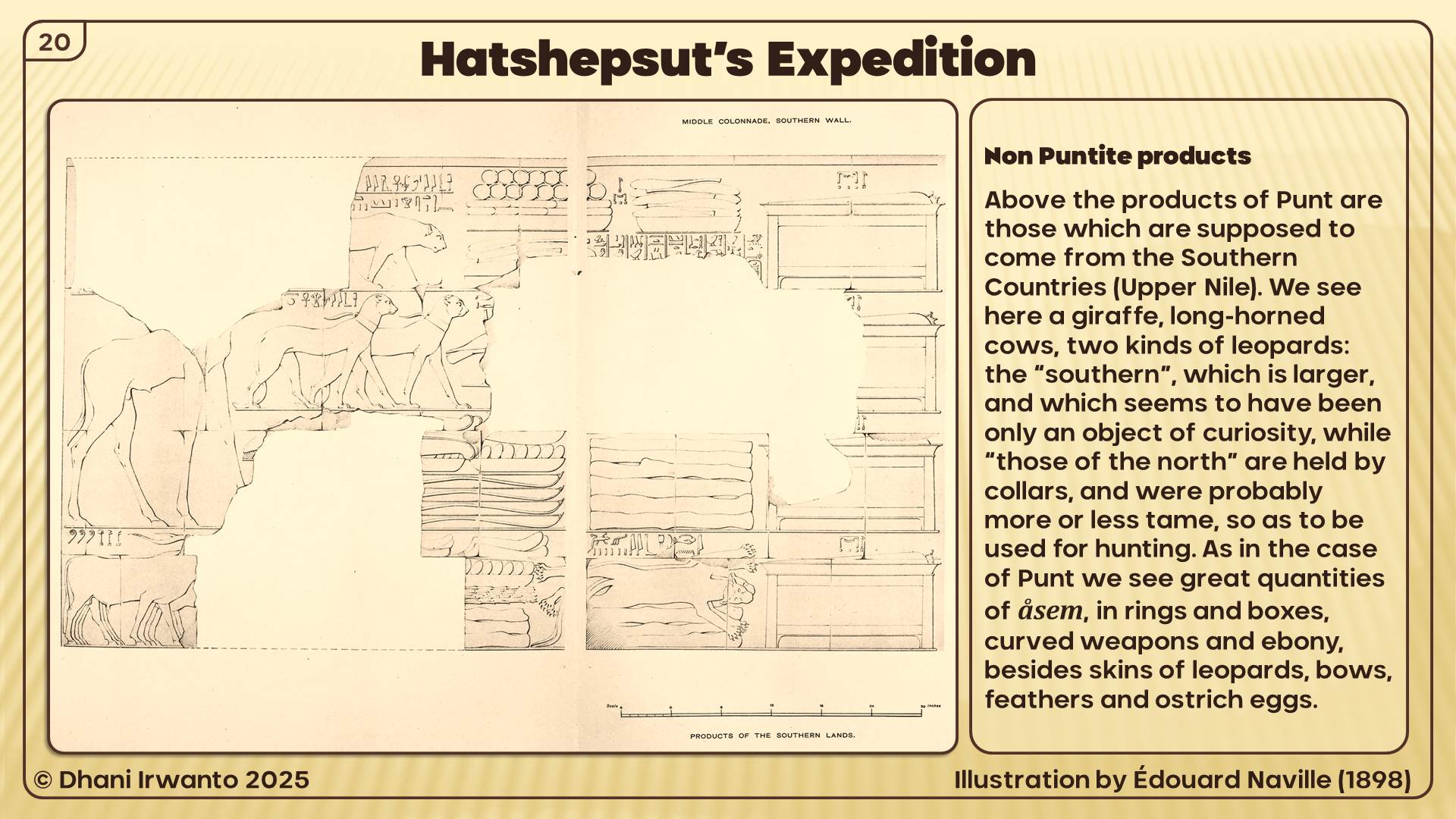
A research by Dhani Irwanto since 2015 Explore the research
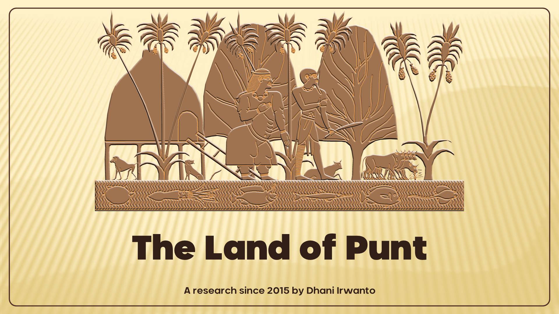
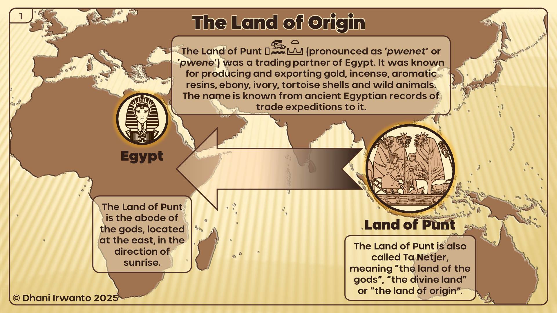
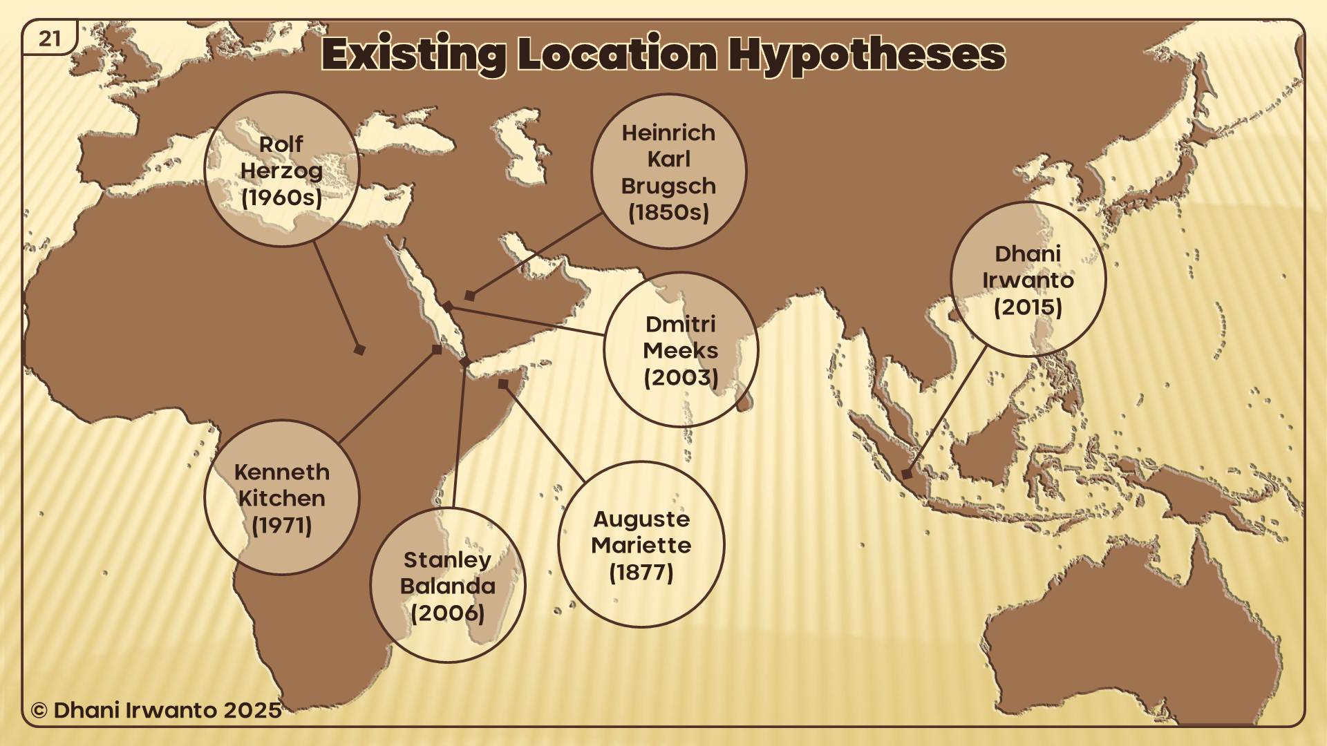
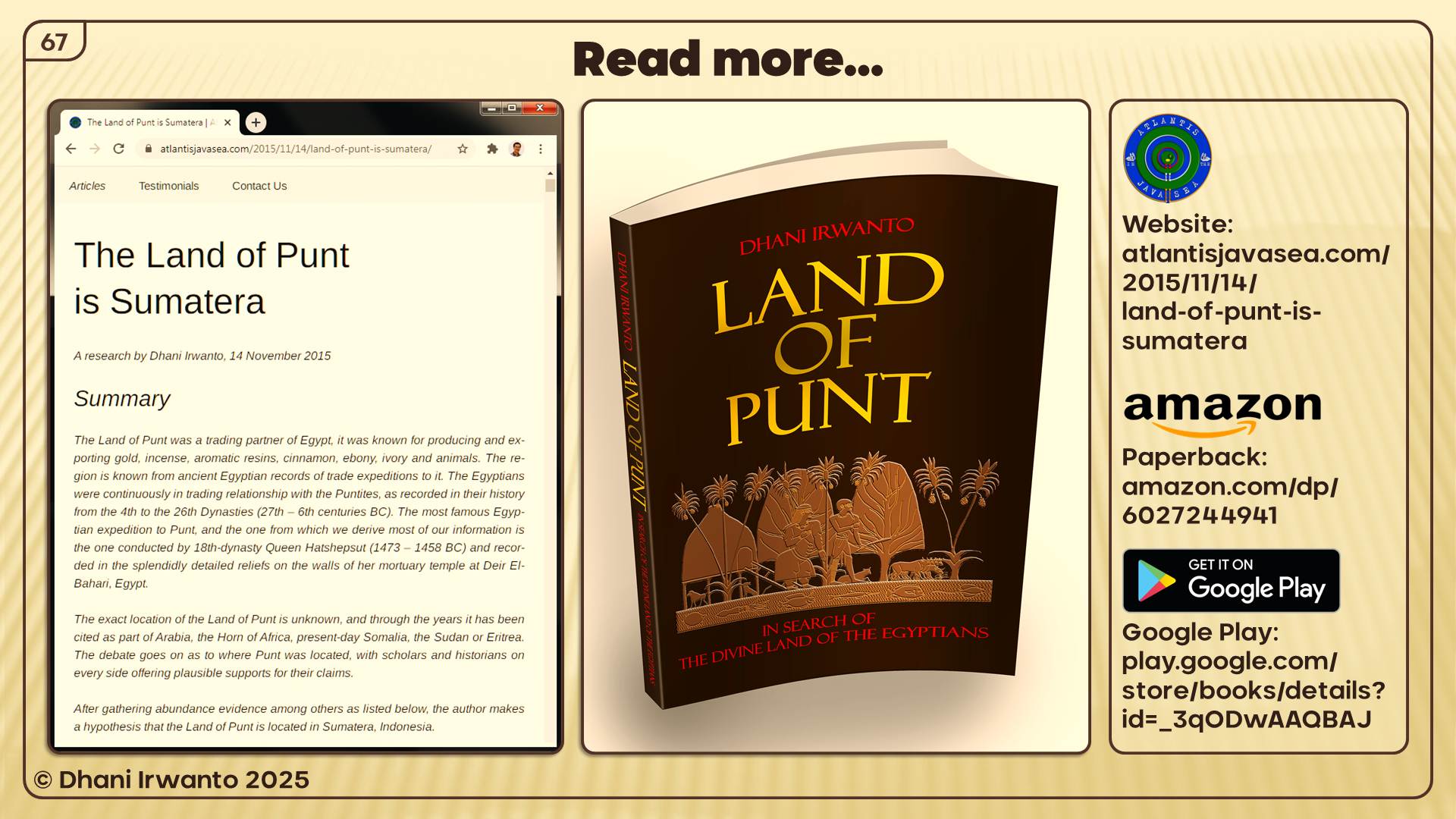
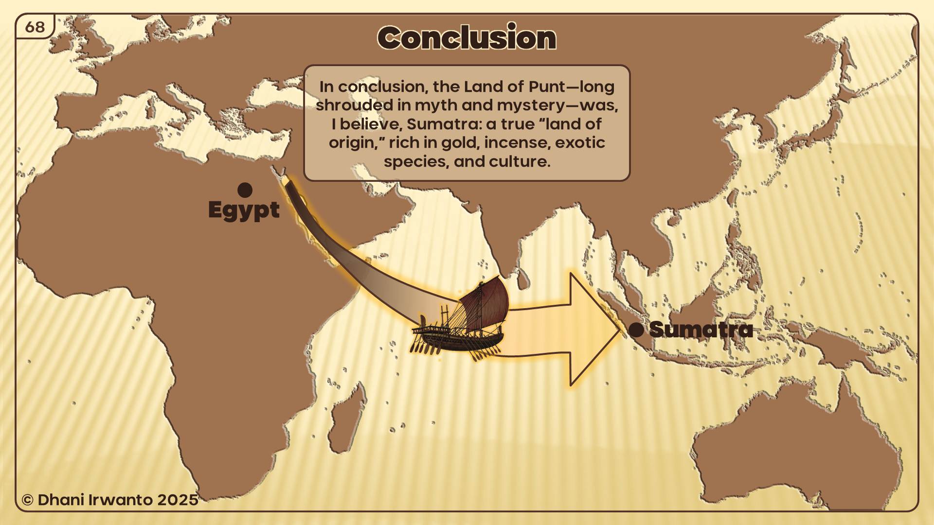
The Land of Punt has long stood as one of history’s enduring mysteries. Ancient Egyptian inscriptions speak of a distant, exotic land—rich in gold, incense, precious woods, and rare animals—referred to as “Ta Netjer,” the land of the gods, or the land of origin. For centuries, the true location of Punt has been debated by scholars, with hypotheses ranging from Africa to Arabia and beyond. Yet, none have fully accounted for the rich detail preserved in the records of Egypt’s trade expeditions.
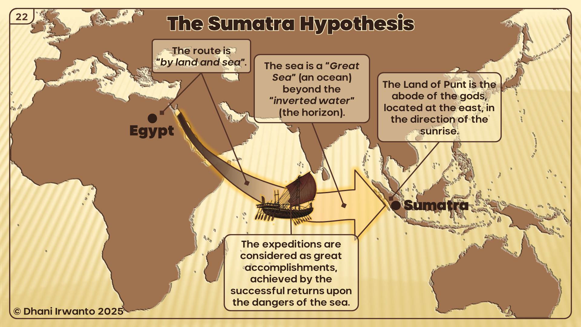
This presentation, the culmination of years of independent research, re-examines the evidence for Punt’s location through an interdisciplinary approach. By carefully analyzing historical texts, archaeological findings, botanical and zoological records, and living cultural traditions, I argue that the Land of Punt is best identified not in Africa, but on the island of Sumatra and its surrounding regions in Indonesia.
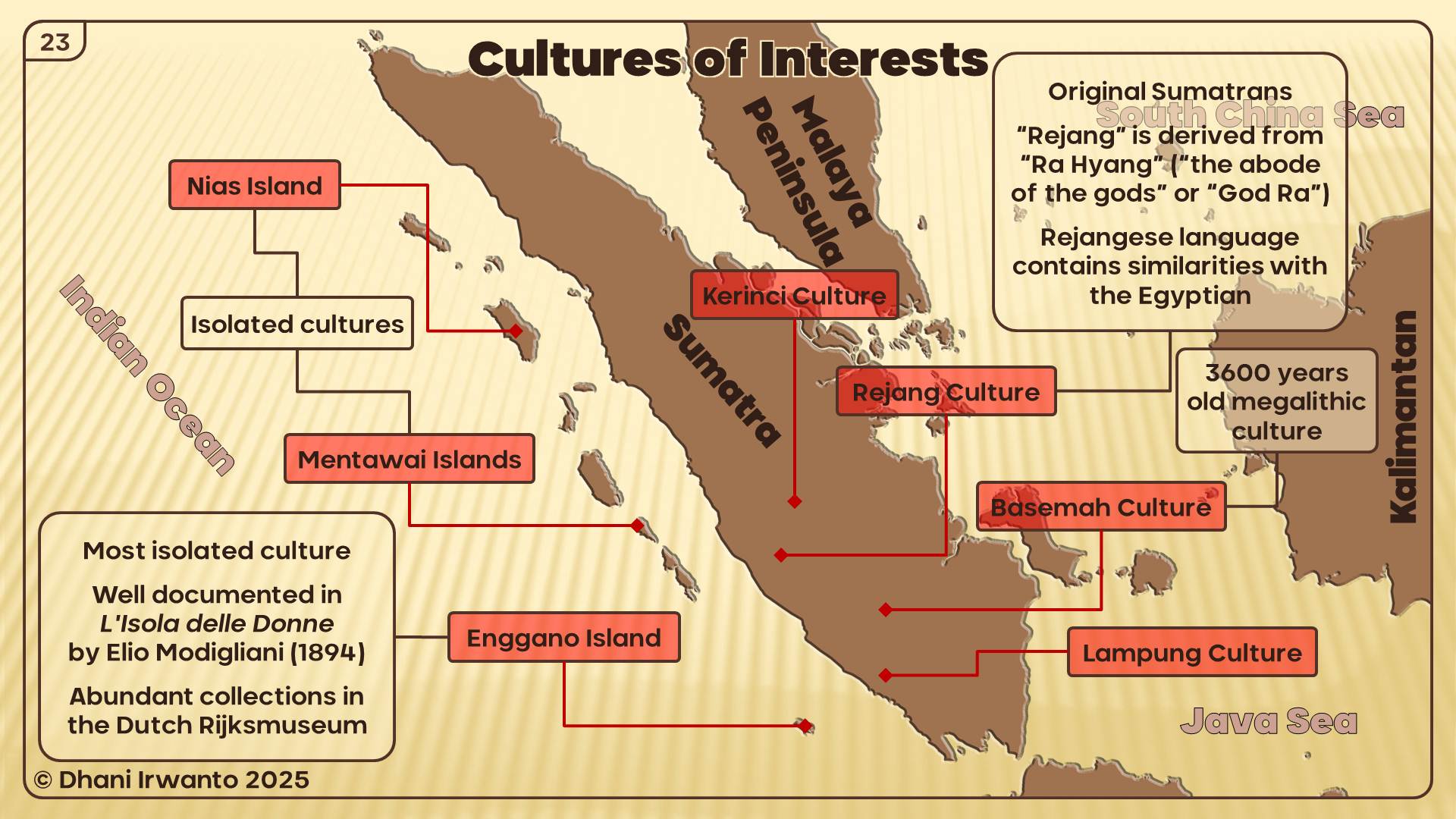
Key evidence—including the flora and fauna described by the Egyptians, the products traded, the architectural styles, and the physical features of Punt’s people—find their closest parallels in Sumatra’s unique environment and ancient cultures. Ancient Sumatran ports such as Bengkulu, Barus, and Pinangsori emerge as strong candidates for Punt’s legendary harbors.
By bringing together linguistic, historical, and ethnographic perspectives, this presentation invites you to reconsider the origins of the Land of Punt and, in doing so, explore new connections between the ancient civilizations of Egypt and Southeast Asia.
Readmore:
***
A research by Dhani Irwanto
A pyramid is a structure whose outer surfaces are triangular and converge to a single point at the top, making the shape roughly a pyramid in the geometric sense. A step pyramid is an architectural structure that uses flat platforms, or steps, receding from the ground up, to achieve a completed shape similar to a geometric pyramid. Step pyramids are structures which characterized several cultures throughout history, in several locations throughout the world. These pyramids are typically large and made of several layers of stone.
As well as menhirs, stone tables, and stone statues, Austronesian megalithic culture in the archipelago also featured earth-and-stone step pyramid structure, referred to as punden berundak, regarded as one of the characteristics of the original culture of the archipelago. These structures have been found and spread throughout the archipelago as far as Polynesia. Most of them are found in the island of Java. Gunungpadang is the biggest and the oldest earth-and-stone step pyramid structure dated ca 25,000 years ago or older (Natawidjaja 2013). The Sukuh and Cetho temples in Central Java (dates are debated) show the Austronesian indigenous elements of step pyramid that somewhat resemble the Mesoamerican pyramids. The huge Borobudur temple is the largest Buddhist temple in the world, which allegedly built on the previous earth-and-stone step pyramid. The construction of stone pyramids was based on the native belief that mountains and other high places are the abode of the spirits of the ancestors, or the most ideal pilgrimage places to worship them. They feel the need for pilgrimages, in addition to worship, in a belief that the ancestral spirits can solve their everyday life problems.

The earth-and-stone step pyramids were normally built on natural or manmade mounds, hills or hillsides. As the civilizations were developing, they built larger pyramids so that more stones were required. The majority of the weight are closer to the ground and material higher up on the pyramid will be pushing down from above. The stones could pose problems on the strength of the earth to hold the weight – a case that has been observed at Borobudur temple. Therefore, pyramids with heavier stone weight pushing on the earth fill are observed to have less earth fill or even without it. This design allowed early civilizations to create stable monumental structures. Dry stones were used in the construction where minimum human work are required.
Pyramids have been built by civilizations in many parts of the world. For thousands of years, the largest structures on Earth were pyramids. They spread from Egypt to America, that emerged separately from one another by oceans who supposedly never discovered each other’s existence. There are no firmly established connections between the different civilizations that built them, but their similarities show that they sprang from a common origin. In South and Southeast Asia, architectural elements were added on the terraced plinths of the pyramids, including multiple tower shrines. They gradually transformed into temples that mostly influenced by the Hindu and Buddhist architecture. Some of the temples retain their pyramidal form, such as Gangaikondachola-puram, Thanjavur, Airavatesvara and Srirangam temples in India; Prasat Thom temple in Cambodia; and Borobudur, Sukuh and Cetho temples in Indonesia. Balinese puras are also in the form of earth-and-stone step pyramids, that are vigorously fantastical, with gilt paint and colored glass.

In Mesopotamia, the Sumerians, Babylonians, Elamites, Akkadians and Assyrians built the earliest pyramidal structures, called ziggurats, began near the end of the Early Dynastic Period. They were constructed of sun-dried mud-brick so that little remains of them. The ziggurat was a pyramidal structure with a flat top, built in receding tiers upon a rectangular, oval or square platform. They probably had shrines at the top with the access would have been by a series of ramps on one side of the ziggurat or by a spiral ramp from base to summit.
The Egyptian pyramids are huge structures built of brick or stone, shaped as a reference to the rays of the sun. They began building pyramids after 2700 BCE until about 1700 BCE. The first pyramid was built during the Third Dynasty by king Djoser and his architect Imhotep, as a step pyramid by stacking six mastabas (rectangular, flat-roofed ancient Egyptian tomb). The largest pyramids are the pyramids at Giza (2575 – 2150 BCE).
In Mesoamerica, such as the Aztecs, Maya, Purépechans, Teotihuacans and Toltec built pyramids from around 1000 BCE up until the time of the Spanish conquest in the early 16th century. The Mesoamerican pyramids were usually stepped, with temples on top, more similar to the Mesopotamian ziggurat. These are usually made out of stone and mortar but some of the earliest may have been made out of clay. The largest pyramid by volume is the pyramid of Cholula in Mexico.
Other civilizations also built pyramid-shaped structures in the past. There are many square flat-topped mound tombs in China, most of which are ancient mausoleums and burial mounds built to house the remains of several early emperors of China and their imperial relatives. Many native American societies of ancient North America built large pyramidal earth structures known as platform mounds. Andean cultures in Peru had used pyramids in various architectural structures. The Nubian in Sudan built steep-angled pyramids at three sites to serve as tombs for the kings and queens of Napata and Meroë. The Igbo culture in Nigeria built three clay or mud pyramids structures. Two pyramid-like structures are found in Greece, one at Hellenikon and the other at Ligourio. A Greek traveler and geographer Pausanias (2nd century CE) mentions two buildings resembling pyramids in Greece, but neither of these still survive. In the district of Chacona, Spain, six rectangular pyramid-shaped, terraced structures, referred to as the Pyramids of Güímar, are found.
***
Copyright © Dhani Irwanto, 2019. All rights reserved.
A research by Dhani Irwanto, 1 June 2018
In 2017, I visited an island in the middle of the Java Sea, namely the Bawean Island, to deliver a presentation about the island’s connection with Atlantis. I spent a few days there, wandering around the tiny island to observe and talk to every resident I met. There is an interesting thing that I got when talking with them. Some people told a legend about the existence of a mysterious island located on the north of the island, in the middle of the Java Sea, which is now drowned. They also told about the frequent occurrence of fishing boats or vessels that ran aground or lost when sailing near the mysterious island.
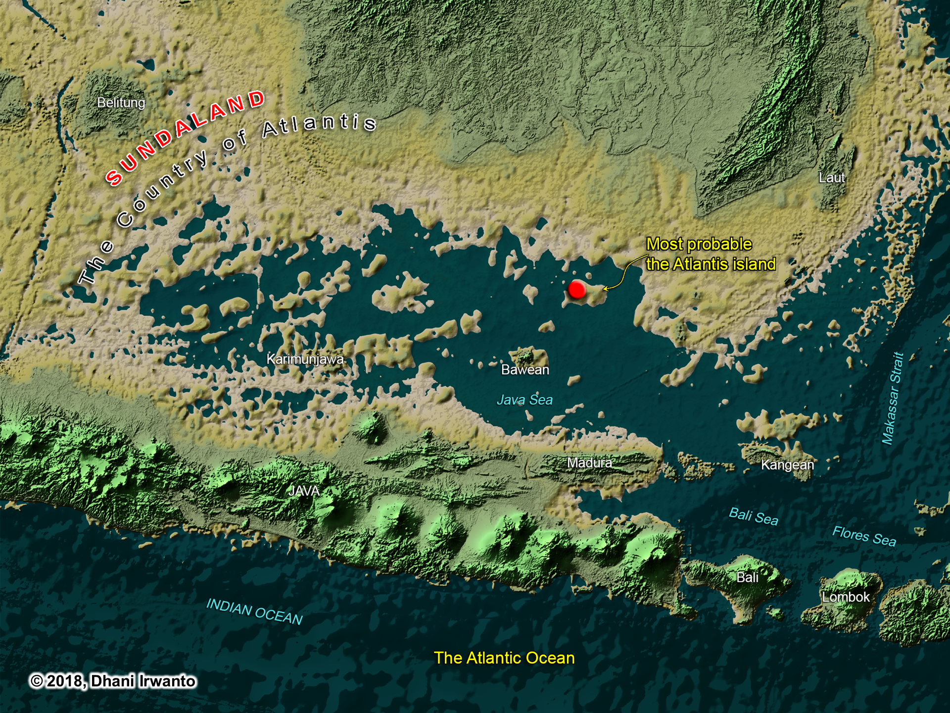
After returning from the island, I thought about opening up the old maps composed by geographers from the sixteenth and seventeenth centuries. After I observed, many maps show the existence of an island located in the northeast of the Bawean Island, with various names such as Nusasua, Nisasira, Nusasira and Nisaira (see attached maps). Then I interpreted the names into Nusasura in the Austronesian language group. Is Nusasura the Island of Atlantis?
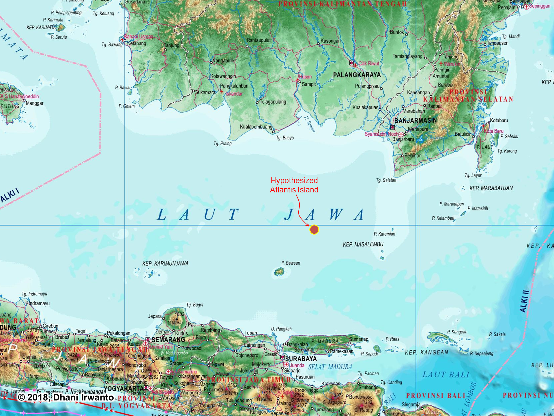

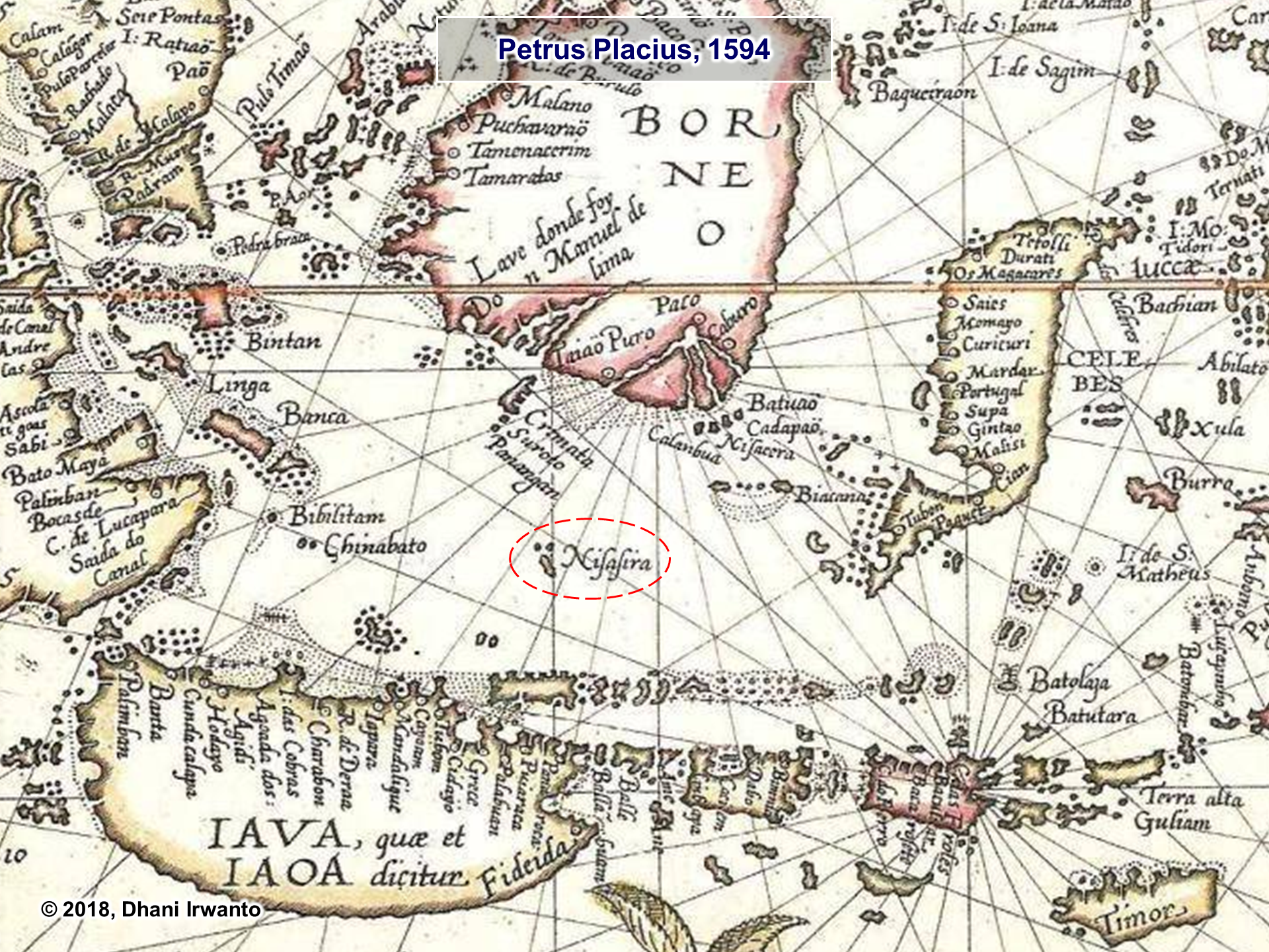
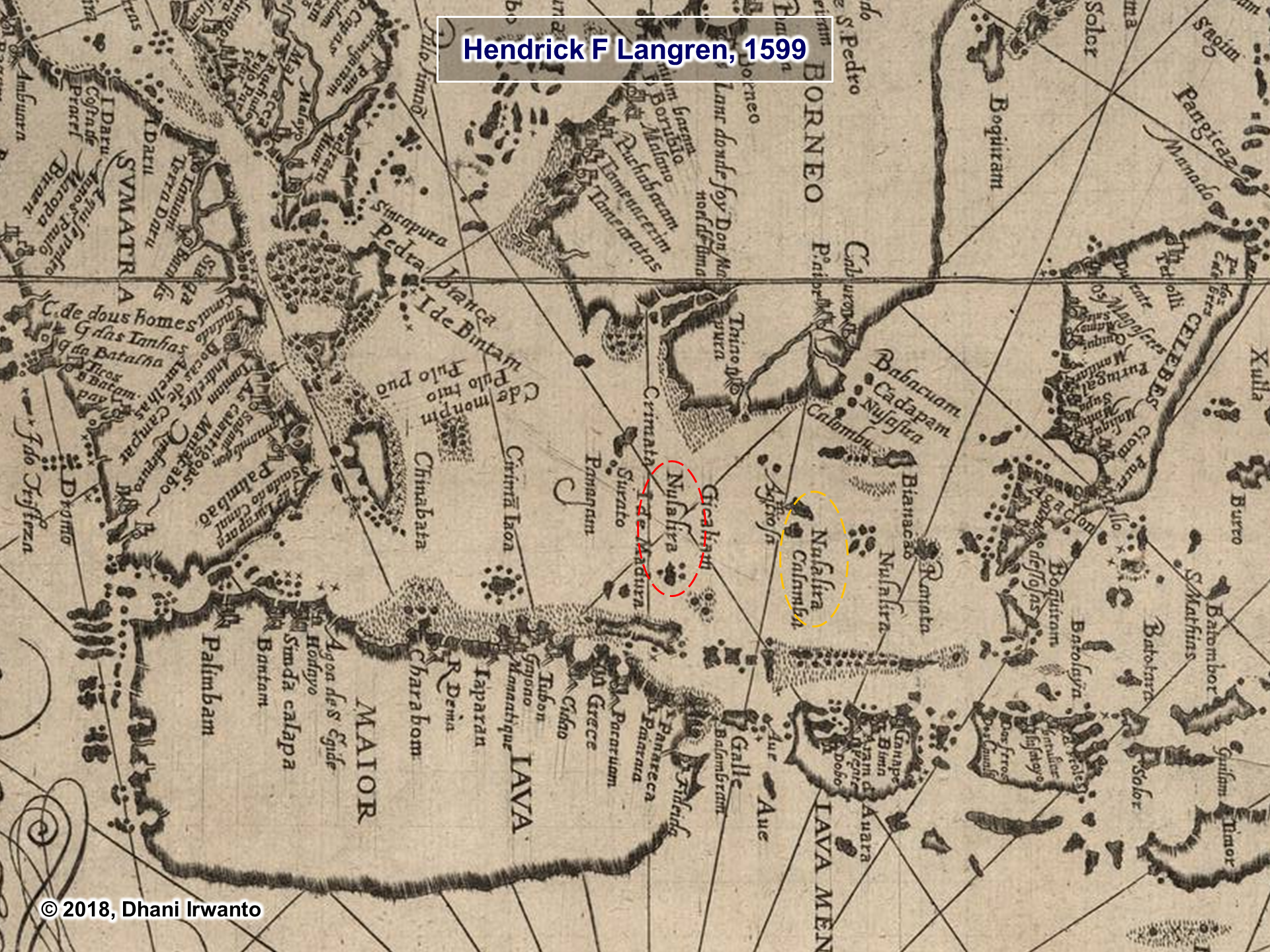
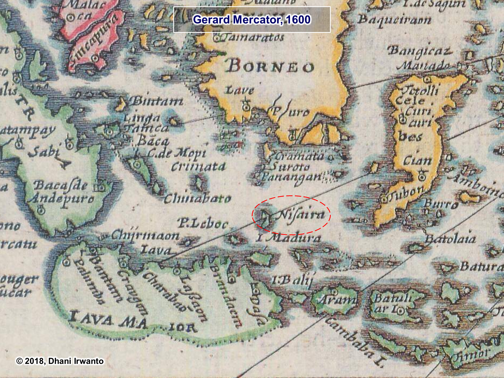
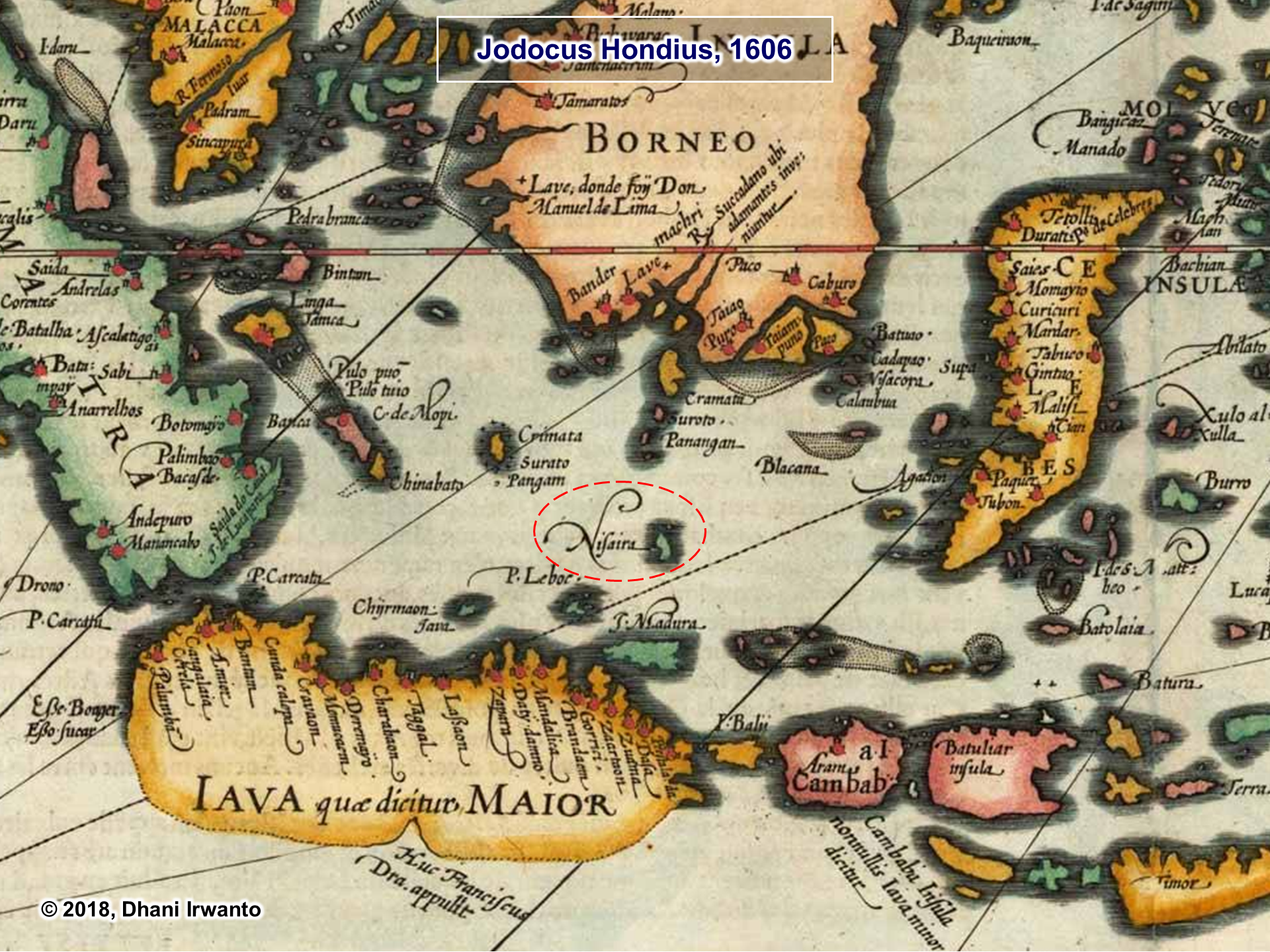
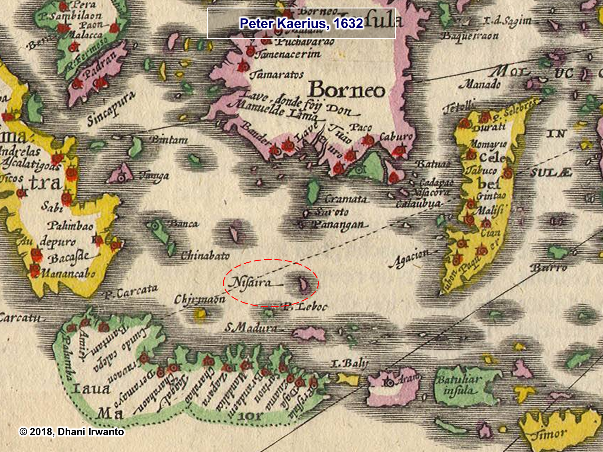
In a research published in 2015, I undertook a hypothesis of the island of Atlantis, where there is the capital city of the kingdom of Atlantis, that is located on the northeast of the Bawean Island. The island is now drowned and overgrown by a coral reef named Gosong Gia or Annie Florence Reef. This coral reef was mapped in detail using multi-beam echosounder some time ago. From the pattern of the coral reef, the structure of the city and its dimensions narrated by Plato can still be seen. The location of the coral reef is more or less the same as the Nusasura shown on the above maps. Please note that the authors of the maps were informed by European sailors who sailed in the Java Sea. The sailors obtained the information about the islands in the Java Sea from the local residents or sailors, who probably also told of the mysterious island and then it was described by the European sailors.

Furthermore, I also observed the ancient records contained in Egypt. From here I obtained a word that sounds like Nusasura, Neserser. In the mythology of the Ancient Egyptians, the island and the lake of Neserser, “the island and the lake of flames” (in the volcanic region) where Osiris and Thoth came from, is often mentioned in their myths. As described in the Papyrus of Nu (in the Book of Dead), the myth tells that Osiris has his throne on the island of Neserser in the center of six or seven concentric circles with a gate at each and they are all in the “lake” of Neserser. The concentric circles were built for Ra by the dwellers of the lake. Thoth had his lands around the lake and he visited Osiris on the island. There was a great flood in the lake of Neserser and somehow these circles of Ra became hidden.
As written in many tomb texts from the Middle Kingdom and the Second Intermediate Periods in the Ancient Egypt, in the concepts of the divinities and the deceased, the Neserser island is a heaven-like place, a place where judgement is passed and the deceased is reborn equipped with a status (god or common being). The Hetep-fields is a kind of paradise under the supervision of the god Hetep with whom the deceased identifies himself, and where he leads the happy life reserved for the privileged. In the concept, Osiris, Horus and Thoth were given the status of gods or ancestral divinities.
The description of Neserser is resemblant to the story of Atlantis.
Again, a sound-like word of Nusasura, Nisir, is also found on the Mesopotamian clay tablets, the name of a sea where Gilgamesh sets out on a series of journeys to search for his ancestor Utnapishtim that has been given eternal life. In 2016, I made a hypothesis that the Epic of Gilgamesh fit the conditions in Indonesia, from the descriptions such as full of noisy birds and cicadas, and monkeys scream and yell in the trees.
Nusasura could have come from the words “nusa” and “asura”, meaning the island of the Asuras. Asuras (also known as Suras and Asuryas) in the dharmic mythology are a class of divine beings or power-seeking deities. Asuras are described as powerful superhuman demigods with good or bad qualities. The good Asuras are called Adityas and are led by Baruna, while the malevolent ones are called Danavas and are led by Vritra. In later Vedic and post-Vedic texts, the benevolent gods are called Devas, while malevolent Asuras compete against these Devas and are considered “enemy of the gods”. In the above Atlantis hypothesis, I made an analogy of the god Baruna with Poseidon, the founder of Atlantis.
The term Asura is linguistically related to the Ahuras of Indo-Iranian people and pre-Zoroastrianism era. In both religions, Ahura, Vouruna and Daeva of pre-Zoroastrianism (Asura, Baruna and Deva of Dharmism) are found, but their roles are on opposite sides. That is, Ahura evolves to represent the good in pre-Zoroastrianism, while Asura evolves to represent the bad in Vedic religion, while Daeva evolves to represent the bad in pre-Zoroastrianism, while Deva evolves to represent the good in Vedic religion. This contrasting roles have led some scholars to deduce that there may have been wars in proto-Indo-European communities, and their gods and demons evolved to reflect their differences. In the Atlantis context, there was a war between Atlantis and “the Athens” (a borrowed name). The Asuras/Ahuras could be analogous to the Atlantean while the Devas/Daevas were “the Athenian”.
Please notice also the linguistic resemblance between Asura and Osiris in the above ancient records of Egypt. Osiris or Atlas have their thrones on the central lands. Note that Osiris was originally the god of water and vegetation. Therefore we can speculate that Asura, Osiris and Atlas are the same person. The name Atlantis was derived from Atlas, Neserser from Osiris and therefore Nusasura from Asura.
Phonetically, Asura is similar to Ashur, the chief god of the Assyrian pantheon, god of military prowess and empire, and namesake of the Assyrian Empire. Some scholars have claimed that Ashur was represented as the winged sun that appears frequently in Assyrian iconography. One variation contain a winged disc with horns, enclosing four circles revolving round a middle circle. The Zoroastrian’s Ahura also have similar representation. From the characters he owns, that are powerful, mighty and has the symbol of solar disc, Ashur could be the association of Asura in the Mesopotamian culture. The circles inside the disc have similar configuration with the land-and-water circles of Atlantis.
***
Copyright © Dhani Irwanto, 2018. All rights reserved.
A research by Dhani Irwanto, 5 March 2017
Lemuria and Mu are sometimes distinct and sometimes interchangeable names for a legendary lost continent, which, according to its proponents, existed in the Atlantic, Indian or Pacific Oceans and had many of the attributes associated with Atlantis. The mysterious lost lands of Lemuria and Mu were conceived of during the 19th century, when the theory of evolution was introduced and was among the advances in the sciences that challenged conventional ways of understanding life. Archaeological discoveries among the ruins of the Egyptians, Maya and other societies were forcing new interpretations of history, and radical forms of mysticism, such as theosophy, were becoming popular.
Lemuria is the name of a hypothetical “lost land” variously located in the Indian or Pacific Oceans. A German naturalist Ernst Heinrich Haeckel (1834 – 1919), proposed that a land bridge spanning the Indian Ocean separating Madagascar from India could explain the widespread distribution of lemurs, small, primitive tree-dwelling mammals found in Africa, Madagascar, India and the Southeast Asian archipelago. Haeckel also suggested that lemurs were the ancestors of the human race and that this land bridge was the “probable cradle of the human race”. The name Lemuria originated with zoologist Phillip Lutley Sclater (1829 – 1913) in 1864 to gave the hypothetical continent in an article The Mammals of Madagascar in The Quarterly Journal of Science.
Lemuria then entered the lexicon of the occult through the works of Russian occultist Helena Petrovna Blavatsky (1831 – 1891). In her massive tome The Secret Doctrine (1888), Blavatsky describes a history originating millions of years ago with the ‘Lords of Flame’ and goes on to discusses five ‘Root Races’ which have existed on earth, each one dying out in an earth-shattering cataclysm. The third of these Root Races she called the ‘Lemurian’, which lived a million years ago, and who were bizarre telepathic giants who kept dinosaurs as pets. The Lemurians eventually drowned when their continent was submerged beneath the Pacific Ocean. The progeny of the Lemurians was the fourth Root Race, the human Atlanteans, who were brought down by their use of black magic, their continent of Atlantis sinking beneath the waves 850,000 years ago. Present humanity represents the Fifth Root Race. Blavatsky also describes survivors of the catastrophic destruction of Lemuria escaping to become the ancestors of some of the Aboriginal tribes of Australia. She maintained that she took all of her information regarding Lemuria from the Book of Dzyan, supposed to have been written in Atlantis and shown to her by the Indian adepts known as the ‘Mahatmas’.
According to L Sprague de Camp, Blavatsky’s concept of Lemuria was influenced by other contemporaneous writers on the theme of lost continents, notably American congressman Ignatius L Donnelly, American cult leader Thomas Lake Harris and the French writer Louis Jacolliot. What Blavatsky and other occultists since have suggested concerning Lemuria could be partly interpreted as an ideal spiritual condition of the soul, a kind of spiritual-historical vision. Nevertheless, there are some psychics and prophets who even today regard the existence of ancient Lemuria as a physical reality.
Mu is the name of a suggested lost continent whose concept and name were proposed by 19th-century travelers and writers Augustus Le Plongeon and Alice Dixon, who claimed that several ancient civilizations, such as those of Egypt and Mesoamerica, were created by refugees from Mu – which he located in the Atlantic Ocean. Le Plongeon and Dixon constructed an imaginative “history”, with the Maya sites in Yucatán being the cradle of civilization, with civilization then traveling east first to Atlantis and later to Ancient Egypt.
In his books Sacred Mysteries Among the Mayans and Quiches (1886) and Queen Moo and the Egyptian Sphinx (1896), Le Plongeon interpreted part of the text of what was then called the Troano Codex (also known as the Madrid Codex), as revealing that the Maya of Yucatán were the ancestors of the Egyptians and many other civilizations. He also believed that an ancient continent, which he called Mu, had been destroyed by a volcanic eruption, the survivors of this cataclysm founding the Maya civilization. Le Plongeon actually got the name “Mu” from Charles Étienne Brasseur de Bourbourg, who in 1864 mistranslated the Troano Codex using the de Landa alphabet. Researchers who have tried to use the de Landa alphabet have reported that it is completely erroneous. Le Plongeon’s credibility was badly damaged by this attempted translation of the Troana Codex. Recent research into the Mayan “alphabet” has shown it to not consist of hieroglyphics but logograms. Recent translations of the Troano Codex have shown it to be a treatise on astrology. Actually, the existence of Mu was already being disputed in the Le Plongeon’s time.
This concept of lost civilization of Mu was popularized and expanded by American Colonel James Churchward, who asserted that Mu was once located in the Pacific, with his publication of The Lost Continent of Mu in 1931. He claimed that the lost continent of Mu had once extended from an area north of Hawaii southwards as far as Fiji and Easter Island. According to Churchward, Mu was the original Garden of Eden and a technologically advanced civilization which boasted 64 million inhabitants. Around 12,000 years ago Mu was wiped out by an earthquake and submerged beneath the Pacific. Apparently Atlantis, a colony of Mu, was destroyed in the same way a thousand years later. All the world’s major ancient civilizations, from the Babylonians and the Persians, to the Maya and the Egyptians, were the remains of the colonies of Mu.
Churchward claimed he received this sensational information when, as a young officer in India during a famine in the 1880s, he became friendly with an Indian priest. This priest told Churchward that he and his two cousins were the only survivors of a 70,000 year old esoteric order which originated on Mu itself. This order was known as the “Naacal Brotherhood”. The priest showed Churchward a number of ancient tablets written by the Naacal Order in a forgotten ancient language, supposed to be the original language of mankind, which he taught the officer to read. Churchward later asserted that certain stone artefacts recovered in Mexico contained parts of the Sacred Inspired Writings of Mu, perhaps taking ideas from Augustus Le Plongeon and his use of the Troana Codex to provide evidence for the existence of Mu. Unfortunately, Churchward never produced any evidence to back up his exotic claims, he never published translations of the enigmatic Naacal tablets, and his books, though they still have many followers today, are perhaps better read as entertainment than factual studies of Mu.
The Lemuria and Mu theories disappeared completely from conventional scientific consideration after the theories of plate tectonics and continental drift were accepted by the larger scientific community. The theory affirms that moving plates of the Earth’s crust supported on less rigid mantle rocks causes continental drift, volcanic and seismic activity, and the formation of mountain chains. Geologists regard the theory of a sunken entire continent beneath the Pacific and Indian Oceans as an impossibility. If the massive foundations of a continent to be blown apart by volcanic action, its enormous base rocks would be seen today on the ocean floor. Madagascar and India were indeed once part of the same landmass, but plate movement caused India to break away and move to its present location would take millions of years. They also point out that theories of lost lands in the Atlantic, Indian and Pacific Oceans mostly originate in the 19th century, when knowledge of the area was limited and well before the ocean floor had been mapped.
Lemuria and Mu existence is now considered to have no factual basis. The very facts that the theory was conceived to explain are now seen to be false. They are today considered to be fictional places, and books on the subject are generally found in the religion and spirituality sections of book stores. The vast land submergence and the population dispersal, occurred during and after the sea level rise of the Last Glacial period, are indeed now widely accepted by the larger scientific community, but the 19th century approach of Lemuria and Mu to prove the existence is outdated and has no factual basis.

World ocean map in the height of the Last Glacial Maximum period. Sundaland is the only inhabitable landmass which now partly disappear.
***
A research by Dhani Irwanto, 25 May 2016
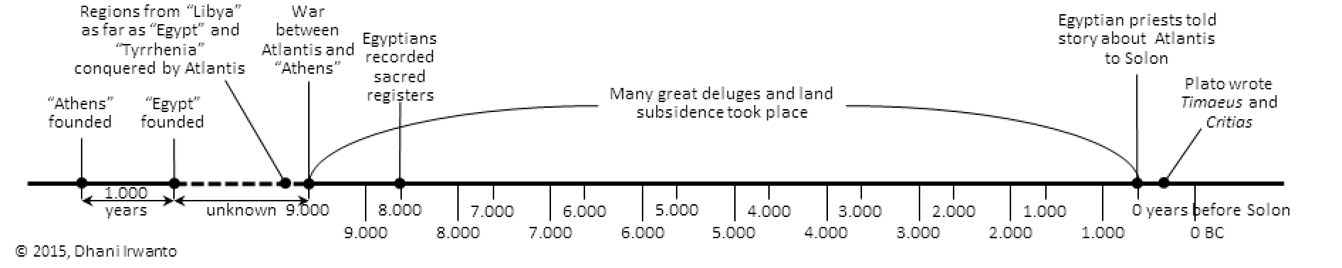
From the Timaeus Sections 23e and 24a: “She founded your city a thousand years before ours, receiving from the Earth and Hephaestus the seed of your race, and afterwards she founded ours, of which the constitution is recorded in our sacred registers to be eight thousand years old. As touching your citizens of nine thousand years ago, I will briefly inform you of their laws and of their most famous action …”
From the Critias Section 108e: “… nine thousand was the sum of years which had elapsed since the war which was said to have taken place between those who dwelt outside the Pillars of Heracles and all who dwelt within them …”
From the Critias Sections 111b and 111c: “Many great deluges have taken place during the nine thousand years, for that is the number of years which have elapsed since the time of which I am speaking; and during all this time and through so many changes, there has never been any considerable accumulation of the soil coming down from the mountains, as in other places, but the earth has fallen away all round and sunk out of sight.”
Based on the above narratives, the timeline of Atlantis story is made as below.
A research by Dhani Irwanto, 19 April 2016
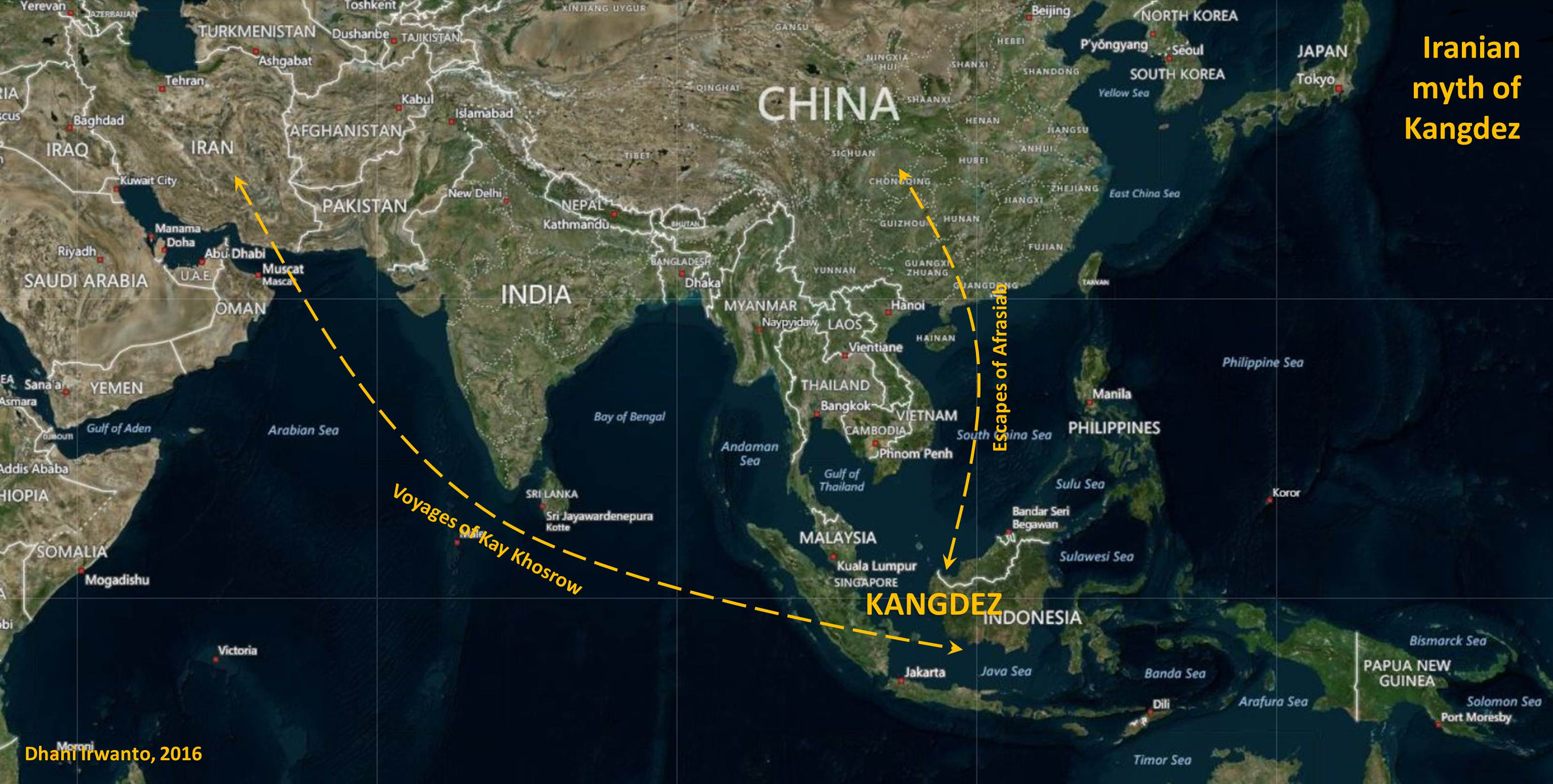
Kangdez refers to a mythical, paradise-like fortress in Iranian folklore, means “Fortress of Kang”. In Ferdowsi’s Shahnameh, Kangdez becomes Gangdez.
The Middle Persian Pahlavi texts mention Kangdez as being founded by Siyavakhsh (Siavosh in the Shahnameh). In the Bundahishn and Dadestan i-Denig, Kangdez was conquered by Kay Khosrow. In Pahlavi Zoroastrian eschatological works, Kangdez is the abode of Peshotan, son of King Vishtasp, and Khwarsheed-chihr son of Zarathushtra, who will gather their righteous army there before the final battle against Ahriman and his creatures. In Dinkard the previous information is ascribed to the lost Sudgar Nask of the Sassanid Avesta.
In the Shahnameh, Siavosh, having fled from Kay Kavus to Turan, is granted by Turan’s King Afrasiab a pleasant piece of land, where Siavosh erects the castle Kangdez by miraculous power. In other Persian texts, the construction of Kangdez is attributed to Kay Kavus, Kay Khosrow and even Legendary King Jamshid. The region around the castle Kangdez is described as being rich in water and game, and knowing neither the frost of winter nor the heat of summer. It is thirty farsakh square in size (1 farsakh is about 6.2 kilometers). The walled city of Kangdez is also called Kang-e Siavosh, Kang-e Siyavakhsh, Siavoshgerd and Siyavakhshgerd, in different texts. The combination of urban structures and gardens within the city walls, the absence of heat and frost, as well as several (usually seven) walls or buildings made of different materials is a characteristic description of towns in Iranian lore.
According to the Bundahisn, the Kangdez was originally supported on the heads of dews (also in Pahlavi), but was placed on the ground by Kay Khosrow. It had seven ring walls made of gold, silver, steel, brass, iron, crystal, and lapis lazuli (Bundahisn); or stone, steel, crystal, silver, gold, chalcedony and ruby (Pahlavi). It also had hands and feet, and there was eternal spring. Its dimensions were so enormous that it took a man with horse and chariot fifteen days to drive from one of its fifteen gates to the next (Bundahisn), set 700 parasangs (about 3900 kilometers) apart (Pahlavi). Each gate was the height of fifteen men, and the castle itself was so tall that the arrow of the best archers might not reach the top (Pahlavi).
According to the Pahlavi, the Kangdez was, apparently, at first in the other world, but was invited down to the earth by Kay Khosrow, who addressed it as his sister, since it had been made by his father (Siavosh). It came down in eastern Turan, in the area of Siavosh-kerd, and Kay Khosrow settled “the Iranians” in it, who would not leave it until the coming of Pisyotan (Wistasp’s eschatological son) at the end of time. It had a silver tower with golden crenellations, accommodating fourteen mountains and seven rivers in spate. After the end of the Kayanids, Pisyotan will be king and priest in the Kang until the final battles, which he goes out to fight, but then returns and stays until the Renovation.
Siavosh lived in Kangdez until he was cunningly killed by Afrasiab. When he learnt of his father’s murder, Siavosh’s son, Kay Khosrow, pledged vengance. When Kay Khosrow ascended the throne of Iranshahr, he launched a series of expeditions against Turan and Afrasiab, who he eventually defeated. Afrasiab fled to China and from there sails to Kangdez. Kay Khosrow pursues Afrasiab, puts together a naval force, and sets sail for Kangdez which he reaches after a six-month-long voyage, but Afrasiab has already secretly escaped. Kay Khosrow resides in Kangdez for one year and then sails back to Iran through Turanian territory.
In the Sassanid Avesta, the Vourukasha Sea lies in the extreme East from which all waters come with the wind and clouds. It is described as the “deep sea of salt waters”. Reference is made to tides, of the “waters rising up and going down” and of a southern sea into which the Vourukasha empties and from which it refills causing the tidal ebb and flow. In the Vourukasha Sea is Eranvej, where the peak Hukairya is located. On Hukairya is the world spring and world river known as Aredvi Sura Anahita, the source of water for all the “world’s rivers”. Also on this peak grows the sacred “white haoma”.
In latter literature, Siavosh is said to have built Kangdez on the “frontier” of Eranvej. In the Vourukasha Sea is also mentioned the giant ox from whose back was taken the three sacred fires.
In the Dadestan i-Menog i-Khrad, the location of Kangdez is described as “entrusted with the eastern quarter, near to Satavayes on the frontier of Airan-vego”. Satavayes is a star or constellation. According to late Zoroastrian texts, Kangdez was located beyond Khotan (Hotan now) and China, a year’s voyage (six months for Kay Khosrow) to the East by sea from the Baluchi port of Makran. Arab geographer, al-Biruni, identifies Kangdez with another land of Yamakoti, the legendary easternmost town of the Indian oecumene.
The geographers who used Kangdez as the prime meridian belonged to what is known as the al-Balkhi school, after Abu Mashar al-Balkhi, known in the West as Albumasar. During the Middle Ages, Albumasar was the most renowned of Muslim astronomer/astrologers in Europe. His theories of historical cycles linked with the planets influenced many European astrologers including Nostradamus whose key work Revolutions was based on such concepts. Abu Mashar al-Balkhi placed the meridian in the far East, based his geographical canon on Kangdez as 0 degrees longitude. The reference to 0 longitude alludes to the concept that Kangdez is considered the centre of the earth. Al-Kashi in the 15th century places Kangdez at the extreme East or 180 degrees East longitude, and at the equator (0 degrees latitude).
Descriptions of Kangdez mentioned above, including its location at the extreme far east, in a sea (ocean) which could be reached from Iran by sea (a year or six-month’s voyage), situated around the equator, there was no snow, there were two seasons , outside of China, east of India (according to al-Biruni), many rivers, water and mountains, and there was a row of volcanoes ( “giant ox” where from whose back was taken the three sacred fires) indicate that Kangdez is most likely located in Sundaland. The descriptions of the fortress town of Kangdez, among others, consists of rings of walls coated with precious metals and stones, plenty of water and games, there were eternal springs, there was a tower of silver and gold, built by leaders who glorified (Siavosh or Kay Khosrow) with miraculous power, there were rivers and mountains, consists of plains influenced by sea tides, rivers were fed from the mountains and flow towards the south, and was in the marine environment, show that Kangdez approximately has characteristics similar to Atlantis.
***
Copyright © 2015-2016, Dhani Irwanto
A research by Dhani Irwanto, 8 April 2016
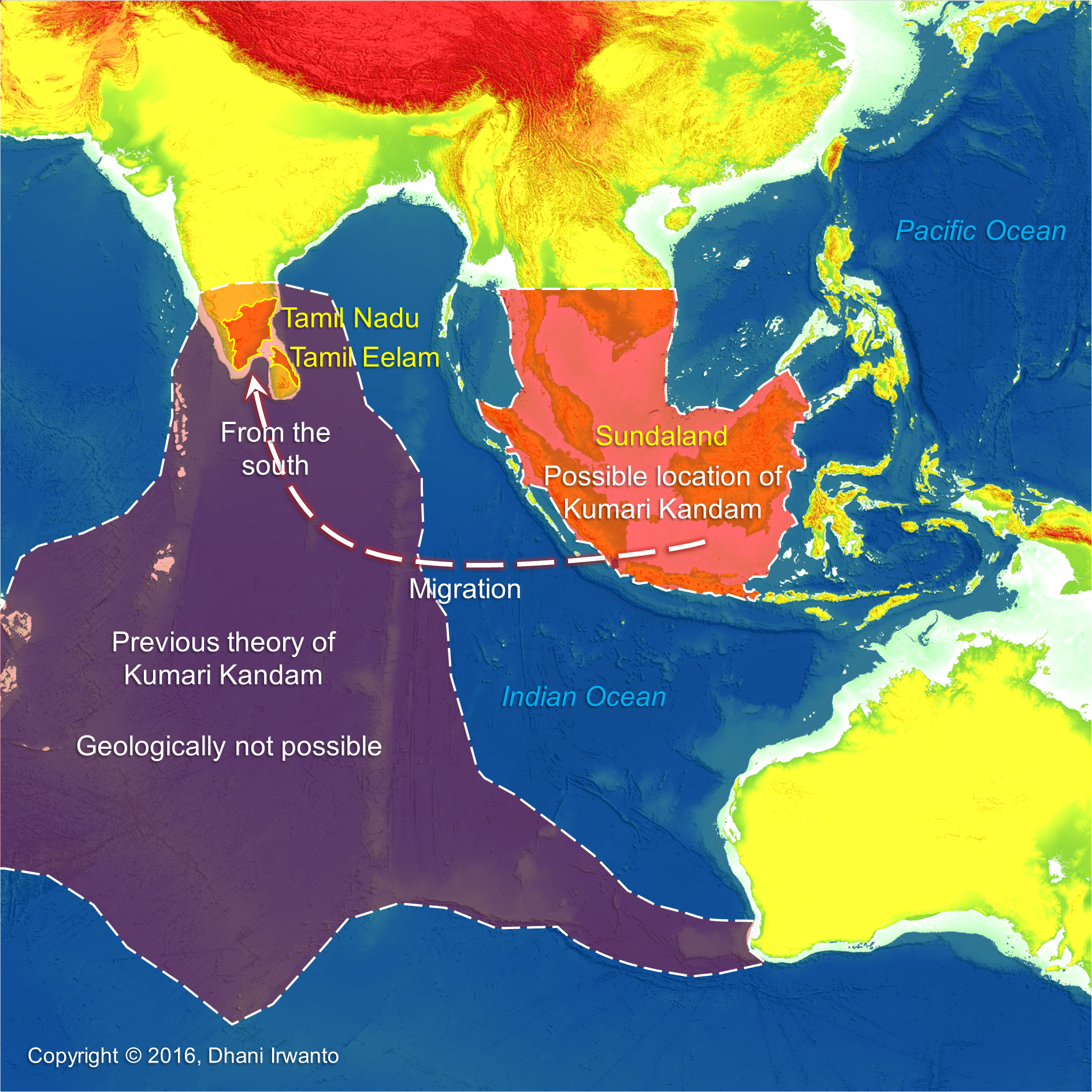
Kumari Kandam refers to a hypothetical lost continent with an ancient Tamil civilization, located south of present-day India, in the Indian Ocean. Alternative names and spellings include Kumarikkantam and Kumari Nadu. Most Tamil revivalists connect it with the Pandyan kingdom mentioned in the works of literary Tamil and Sanskrit.
The words “Kumari Kandam” first appear in Kanda Puranam, a 15th-century Tamil version of the Skanda Purana, written by Kachiappa Sivacharyara (1350 – 1420). Although the Tamil revivalists insist that it is a pure Tamil name, it is actually a derivative of the Sanskrit words “Kumarika Khanda”. The Andakosappadalam section of Kanda Puranam describes the following cosmological model of the universe.
“There are many worlds, each having several continents, which in turn, have several kingdoms. Paratan, the ruler of one such kingdom, had eight sons and one daughter. He further divided his kingdom into nine parts, and the part ruled by his daughter Kumari came to be known as Kumari Kandam after her. Kumari Kandam is described as the kingdom of the Earth.”
Although the Kumari Kandam theory became popular among anti-Brahmin anti-Sanskrit Tamil nationalists, the Kanda Puranam actually describes Kumari Kandam as the land where the Brahmins also reside, where Shiva is worshipped and where the Vedas are recited. The rest of the kingdoms are described as the territory of the Mlecchas.
Multiple ancient and medieval Tamil and Sanskrit works contain legendary accounts of lands in South India being lost to the ocean. The earliest explicit discussion of a katalkol (“seizure by ocean”, possibly the sea water rise) of Pandyan land is found in a commentary on Iraiyanar Akapporul. This commentary, attributed to Nakkeerar, is dated to the later centuries of the 1st millennium CE. It mentions that the Pandyan kings, an early Tamil dynasty, established three literary academies (sangams). The first two sangams were not located in South India now but in an ancient Tamil country in the south which then sank. The first sangam flourished for 4,400 years in a city called Tenmaturai, attended by 549 poets (including Agastya) and presided over by gods like Shiva, Kubera and Murugan. The second sangam lasted for 3,700 years in a city called Kapatapuram, attended by 59 poets (including Agastya, again). The commentary states that both the cities were “seized by the ocean”, resulting in loss of all the works created during the first two sangams. The third sangam was established in Uttara (North) Madurai, where it is said to have lasted for 1,850 years. The Pandyan capital of Kapatapuram finds mention in the Ramayana and Chanakya’s Arthasastra (ca 4th century BCE).
Nakkeerar’s commentary does not mention the size of the territory lost to the sea. The size is first mentioned in a 15th-century commentary on Silappatikaram. The commentator Adiyarkunallar mentions that the lost land extended from Pahruli river in the north to the Kumari river in the South. It was located to the south of Kanyakumari, and covered an area of 700 kavatam (a unit of unknown measurement). It was divided into 49 territories (natu), classified in seven categories: elu teñku natu (“seven coconut lands”), elu maturai natu (“seven mango lands”), elu munpalai natu (“seven front sandy lands”), elu pinpalai natu (“seven back sandy lands”), elu kunra natu (“seven hilly lands”), elu kunakarai natu (“seven coastal lands”) and elu kurumpanai natu (“seven dwarf-palm lands”).
A mountain range had forty-eight high peaks. Four rivers were originated from Meru Malai: Kumari Aaru, Peru Aaru, Pahruli Aaru and Kanni Aaru. The Pahruli river was excavated to irrigate the mountain valley by the Pandyan King Nediyon. Ruby was mined from the mountain Mani Malai and gold from Meru Malai. It is said that Chinese laborers were employed by the Pandyan King and when they went down the mines they appeared like a huge army of small ants, therefore, they were called “the gold mining ants”.
Other medieval writers, such as Ilampuranar and Perasiriyar, also make stray references to the loss of antediluvian lands to the south of Kanyakumari, in their commentaries on ancient texts like Tolkappiyam. Another legend about the loss of Pandyan territory to the sea is found in scattered verses of Purananuru (dated between 1st century BCE and 5th century CE) and Kaliththokai (6th – 7th century CE). According to this account, the Pandyan king compensated the loss of his land by seizing an equivalent amount of land from the neighboring kingdoms of Cheras and Cholas.
Kumari Kandam is a Tamil legend about ancient civilization geographically located in the Indian Ocean and then sank into the ocean. Though many Tamil writers do not assign any date to the submergence of Kumari Kandam, resorting to phrases like “once upon a time” or “several thousands of years ago”, but the stories are consistent with the theory of post-glacial been widely acceptable by scientists. This ancient Tamil civilization was located south to Tamil now, or to go to their new land they reached from the south. Vast land which sank in the geological past is not other than Sundaland. Previous theories hypothesized that the vast mainland of Kumari Kandam was located in the south of the Indian subcontinent, but the theory of tectonic plate movement does not support the existence of such land within some thousands years back. It can be presumed that Kumari Kandam is having a relationship with Atlantis or other civilizations thereafter.
The years of the three stages of sangams are summed up to a date between 11,000 and 12,000 years BP, almost the similar number by the Plato’s dating on Atlantis of 11,600 BP, which could relate the Pandyan Kingdom to Atlantis. The mentions of mountain ranges which had forty-eight high peaks, the four rivers originated from the mountains, and the mining of gold and precious stones coincidentally match the Biblical Garden of Eden hypothesized by the author in the southern Kalimantan. The mountain Meru Malai, where there were mountain ranges which had forty-eight high peaks coincidentally match the Malea Mountains in the Ptolemy’s account of Taprobana, in which the author hypothesizes as the Malawi region in Kalimantan on the Schwaner-Muller mountain ranges. These mountain ranges have tens of peaks, to the south lays an expanse of alluvial plain and the origins of four main rivers: Kahayan, Kapuas, Barito and Negara. The Pahruli river excavated for irrigation purposes also coincidentally match the Plato’s description of Atlantis.
***
A research by Dhani Irwanto, 20 February 2016
In Timaeus Section 24e Plato describes that the country of Atlantis was larger than Libya and Asia Minor put together, and was the way to other islands, and from these you might pass to the whole of the opposite continent which encompasses the true ocean.

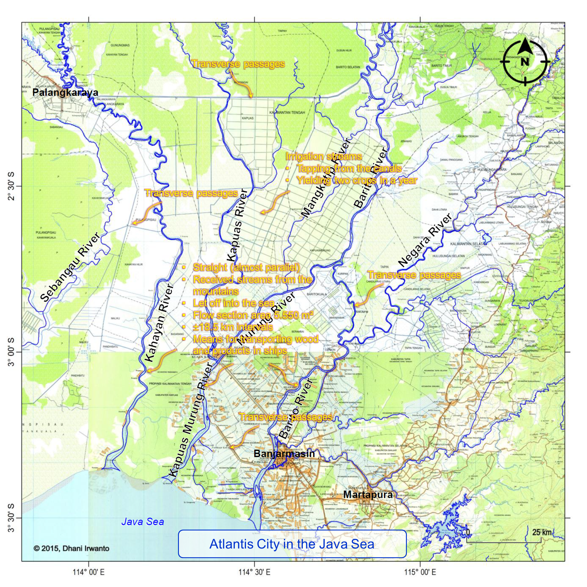
Plato describes the Atlantis Plain plain was level, surrounded by mountains which descended towards the sea, smooth and even, rectangular and oblong shaped, three thousand stadia (about 555 kilometers) long, two thousand stadia (about 370 kilometers) wide, looked towards the south, sheltered from the north, surrounded by mountains celebrated for their number, size and beauty; and had wealthy villages of country folk, rivers, lakes, and meadows.

There were four kinds of channels: the circular (perimeter) ditch, the inland channels, the transverse passages and the irrigation streams. The perimeter ditch was artificial, 100 feet (about 30 meters) deep, 1 stadium (about 185 meters) wide, 10,000 stadia (about 1,850 kilometers) long, carried round the whole plain, received streams from the mountains, winding around the plain, meeting at the city and let off into the sea. The inland canals were straight, 100 feet (about 30 meters) wide, 100 stadia (about 18.5 kilometers) intervals, let off into the perimeter ditch and as means for transporting wood and products in ships. The transverse passages were cut from one inland canal into another. The irrigation streams tapping from the canals were meant to irrigate the land in the summer (dry season) while in the winter (rainy season) had the benefit of the rains.

A research by Dhani Irwanto, 3 February 2016
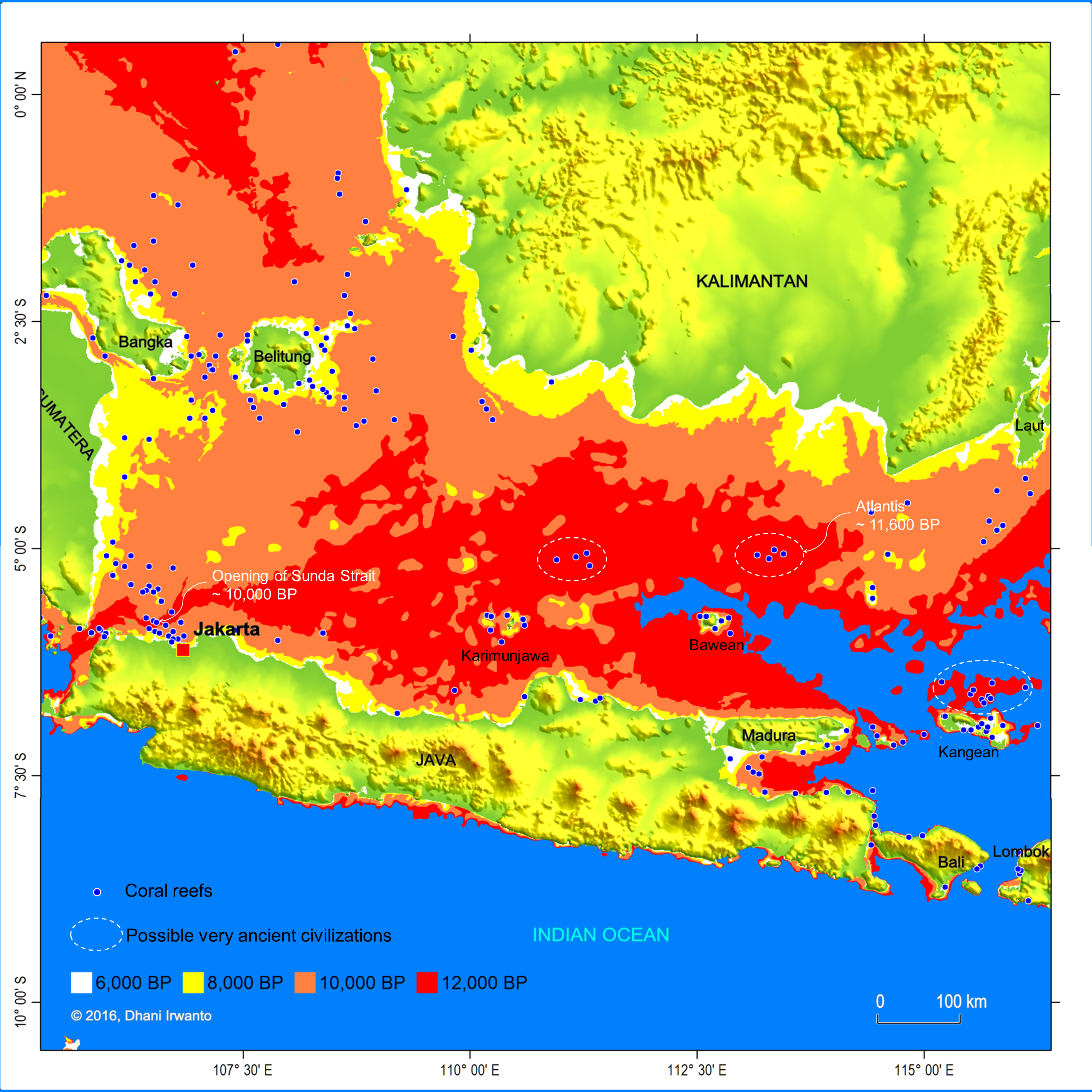
Coral reefs are diverse underwater ecosystems held together by calcium carbonate structures secreted by corals. Coral reefs are built by colonies of tiny animals found in marine waters that contain few nutrients. Most coral reefs are built from stony corals, which in turn consist of polyps that cluster in groups. The polyps belong to a group of animals known as Cnidaria, which also includes sea anemones and jellyfish. Unlike sea anemones, corals secrete hard carbonate exoskeletons which support and protect the coral polyps. Reefs grow best in warm, shallow, clear, sunny and agitated waters.
Coral reefs begin to form when free-swimming coral larvae attach to submerged hard surfaces. As the corals grow and expand, reefs take on one of three major characteristic structures – fringing, barrier or atoll. Fringing reefs, which are the most common, project directly from the hard surfaces, forming reefs and expand in horizontal and vertical directions. Barrier reefs also project, but at a greater distance. If a fringing reef forms around a rocky island that subsides completely below sea level while the coral continues to grow upward, an atoll forms.
The Sunda shelf was exposed during the Ice Age, the most recent glacial period occurring during the last years of the Pleistocene, from approximately 110,000 to 12,000 years ago. It was in the Sundaland that man first found the ideal climatic conditions for development, and it was there that he invented farming, structure building, seafaring and civilization from 70,000 years ago. People of these civilizations were dependent on water for their mobilizations, so coastal areas were the most suitable places to live and then communities were formed there. They used stones and woods to build houses and other buildings since these materials were abundant in the region.
The Ice Age waned during the period 14,000 – 7,000 years ago that accompanied by sea level rise – as much as 130 m. The costal communities then moved to adjust the changing coastlines and remnants of their buildings were left sank under the sea. Finding the most suitable places to grow, coral reefs were formed on these buildings.
Based on the data of coral reefs and bathymetric maps, the author identifies the probable sites and ages of the ancient civilizations, as shown on the attached map. Note that not all of the coral reef sites were ancient civilizations because coral reefs could form on natural hard surfaces as well.
According to Plato’s narrative, Atlantis ended at around 11,600 years ago. Based on the above study, the location of the capital city of Atlantis is expected at one of the very ancient civilization sites shown on the map. Plato also wrote that the capital city of Atlantis at Solon’s time had been covered by a coral reef so it was not navigable.
***
Copyright © Dhani Irwanto, 2016. All rights reserved.
