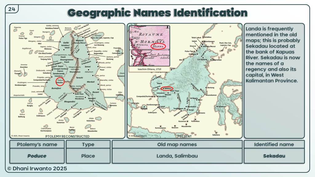
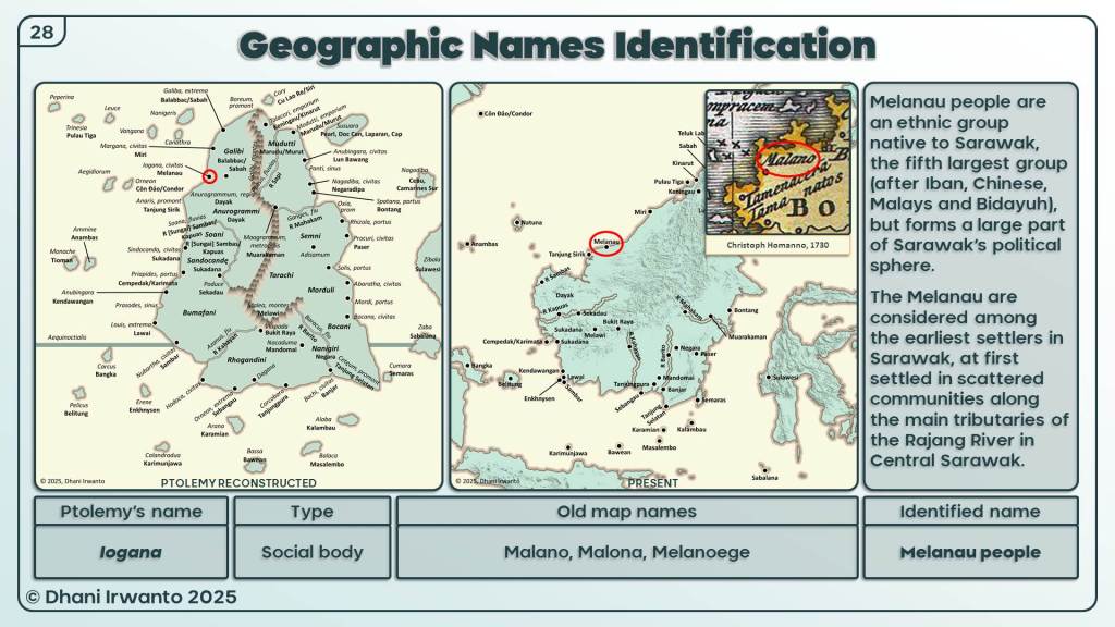
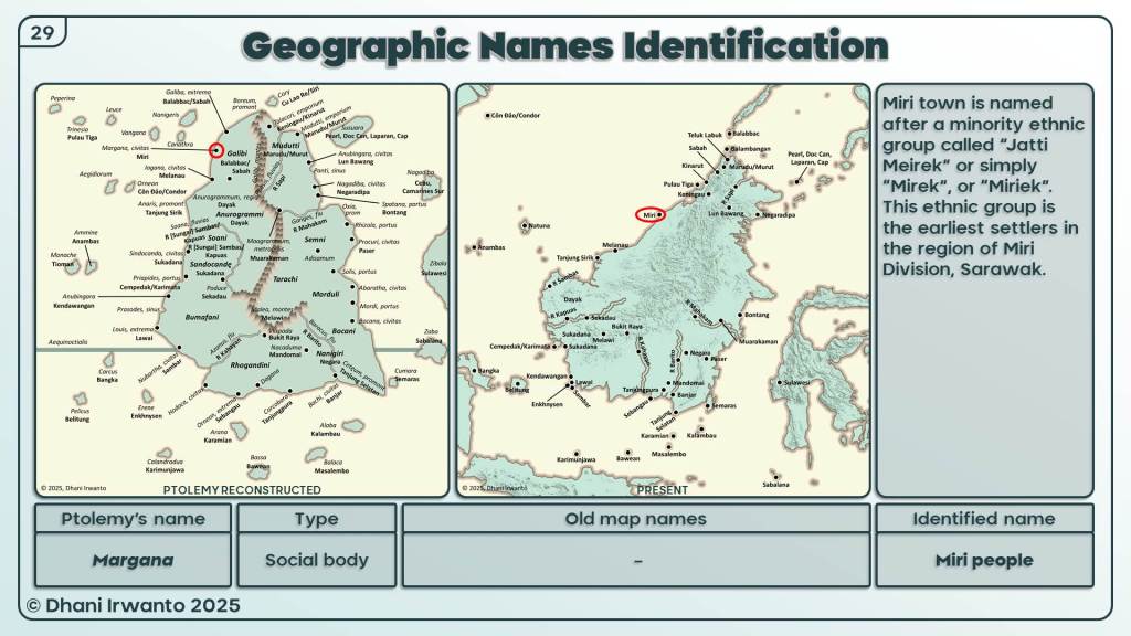
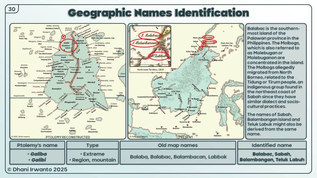
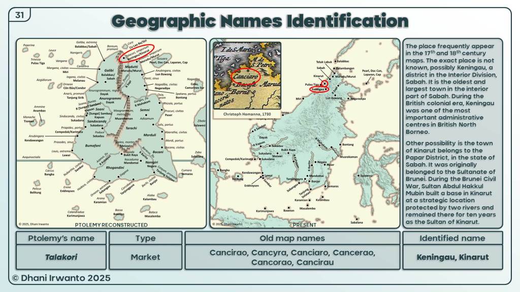
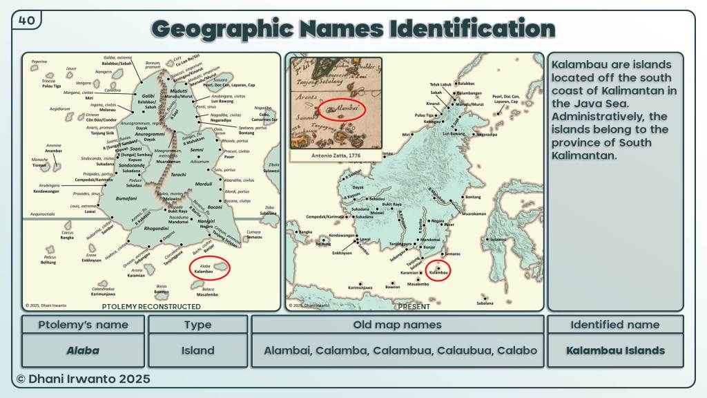
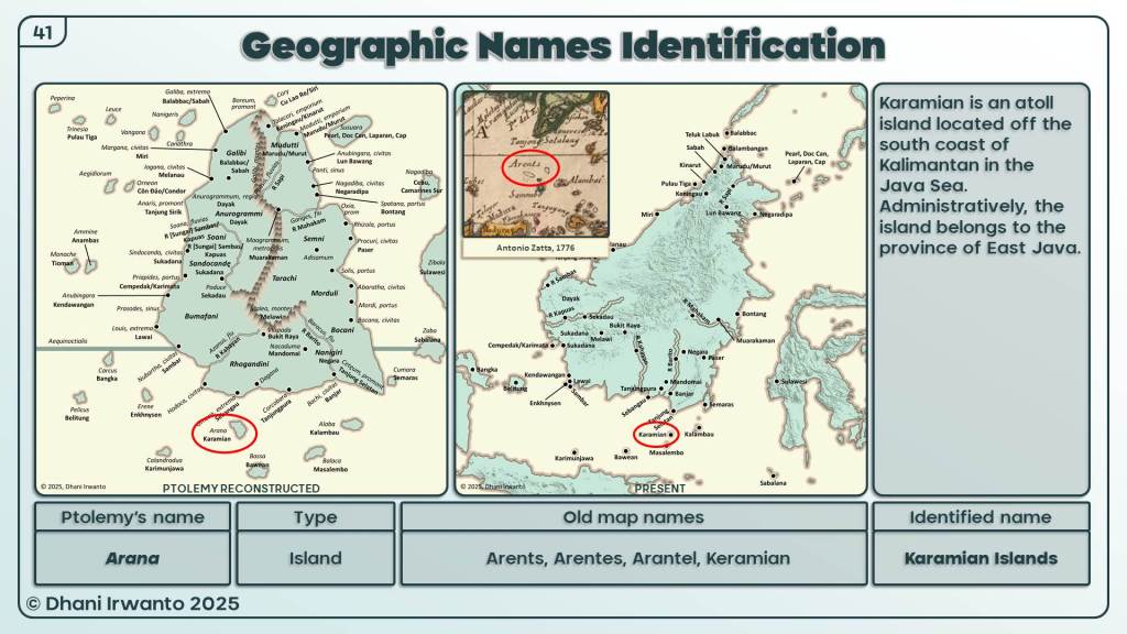
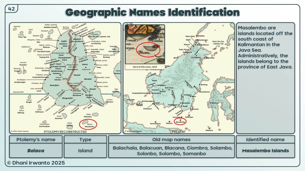
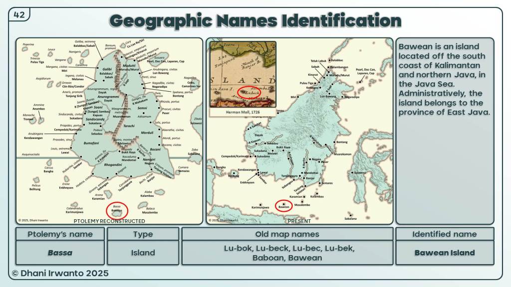
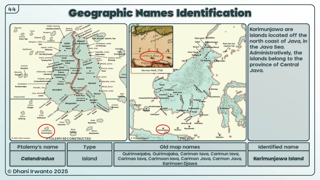
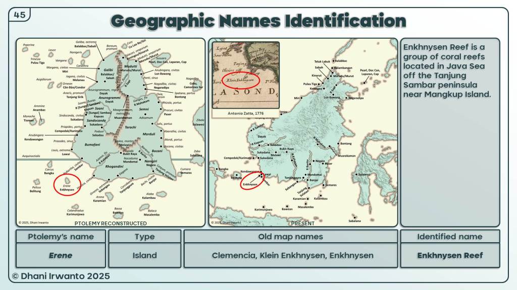
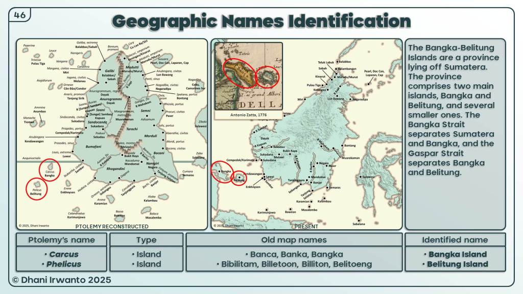
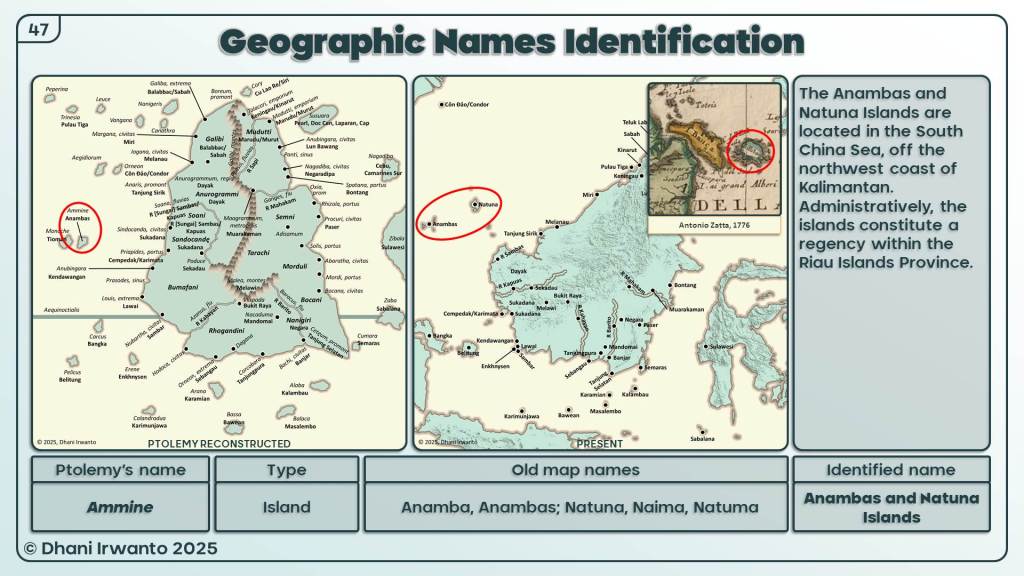
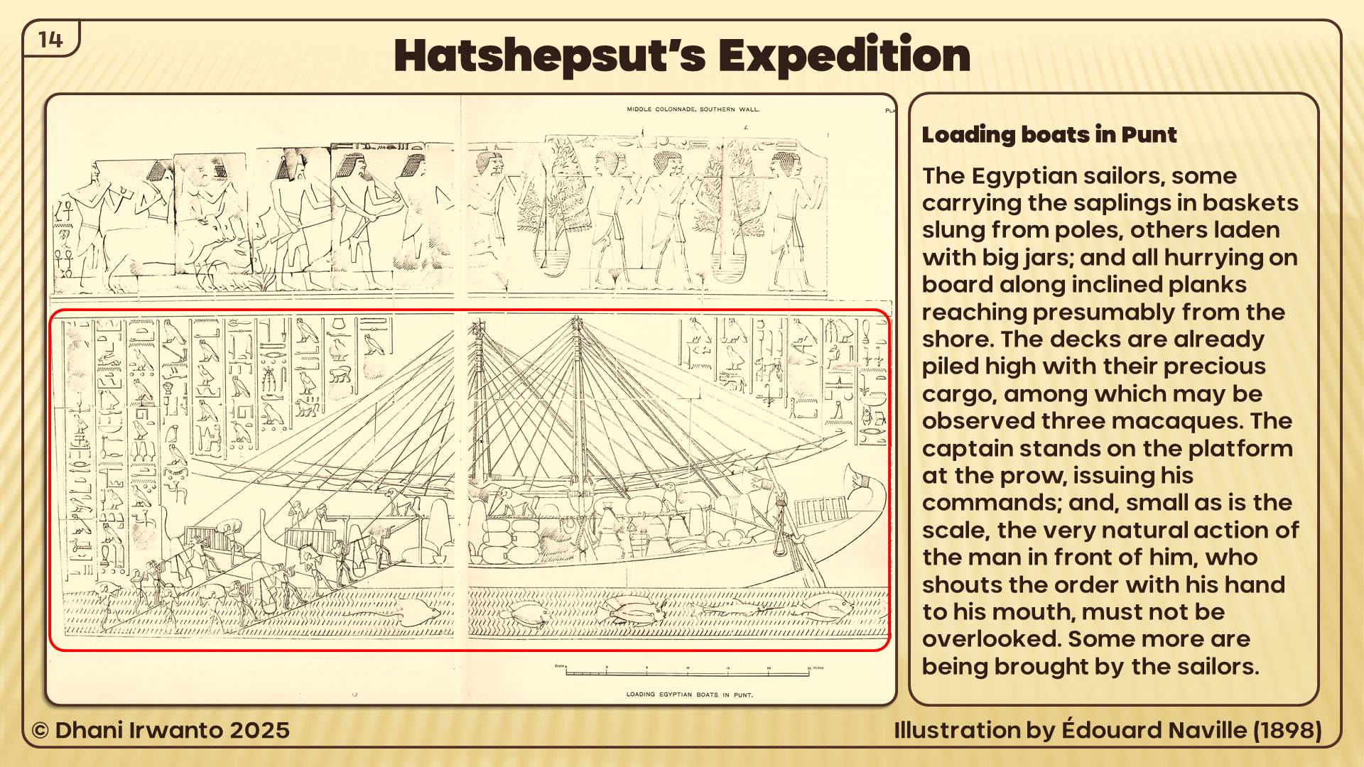
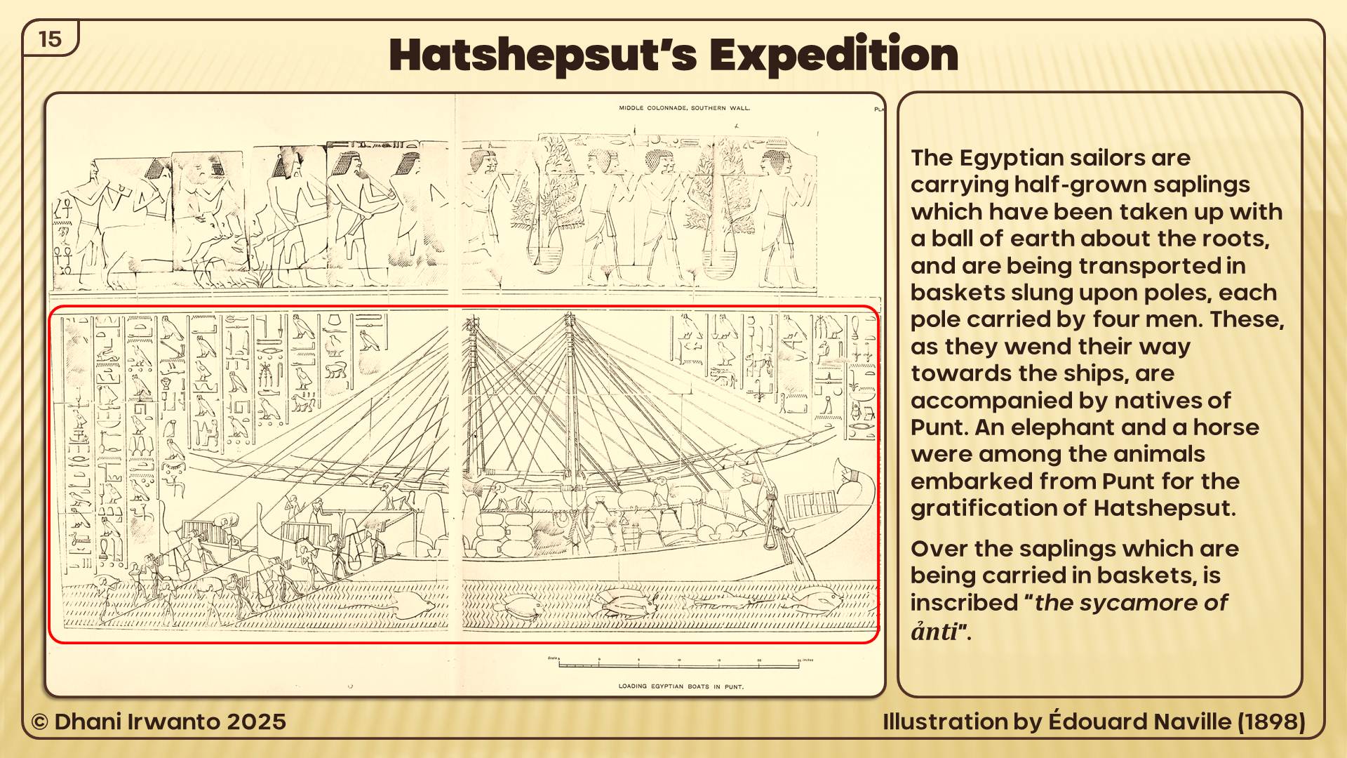
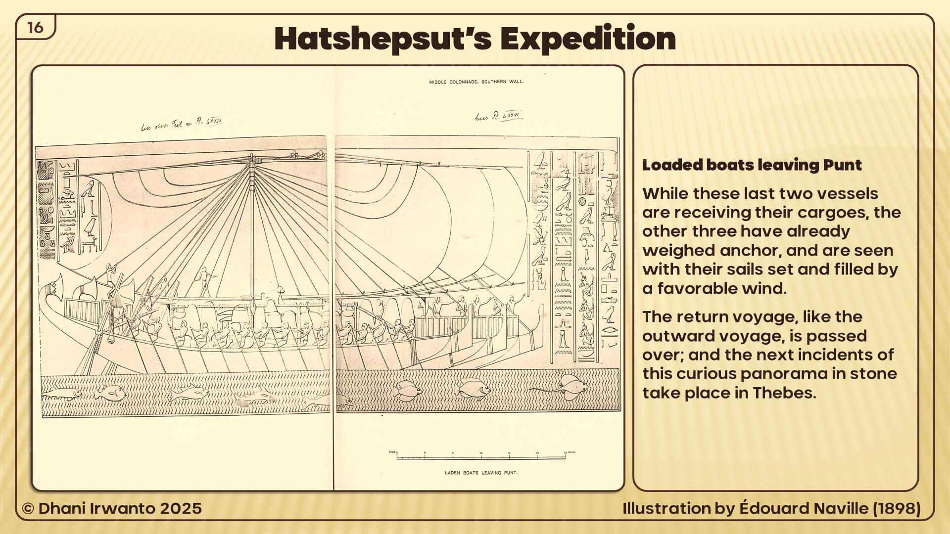
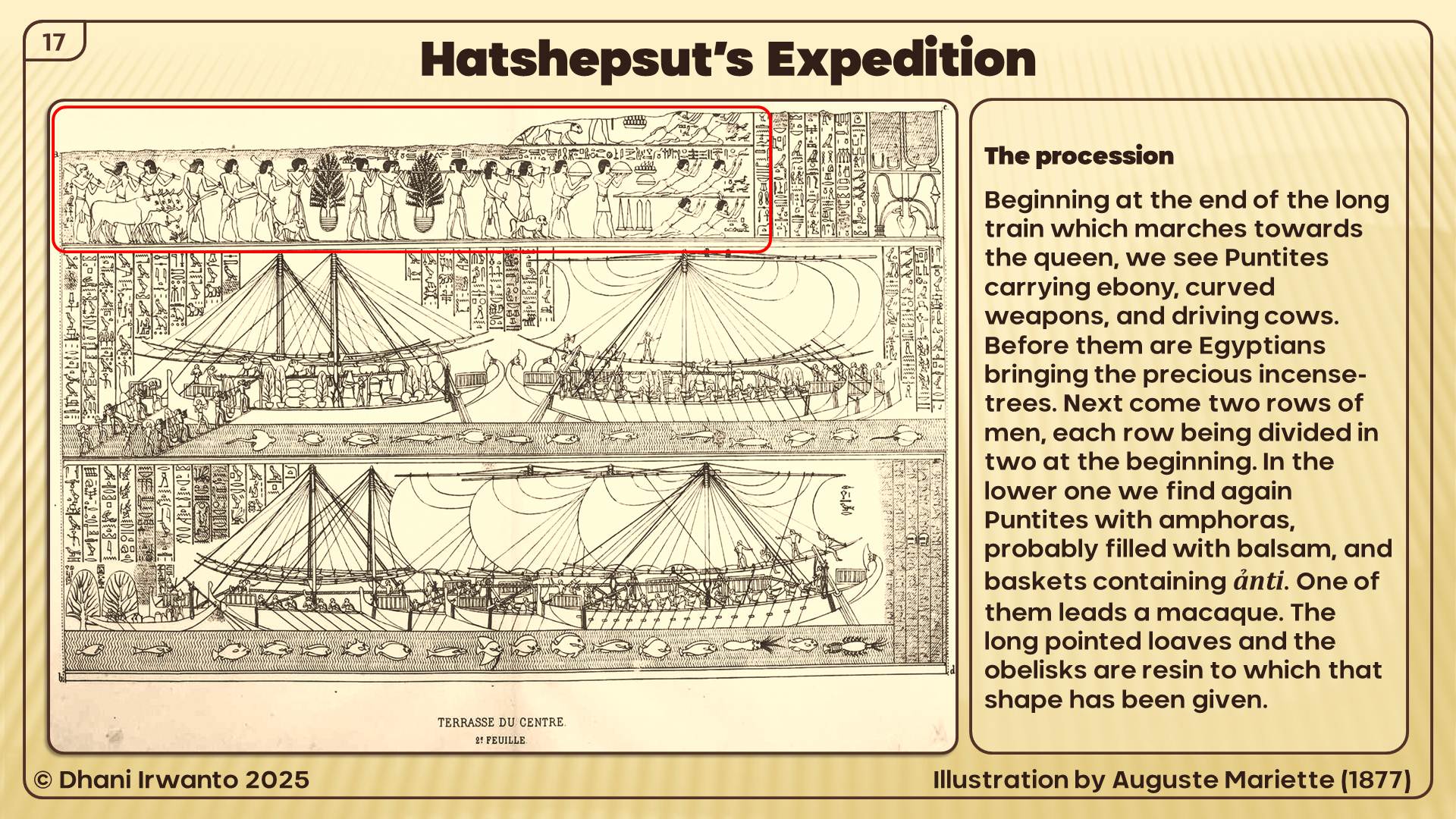
Dhani Irwanto is a hydro civil engineer and better known as a planner and an expert in hydrology, hydraulic structures, dams and hydropower, the profession involving inter-disciplinary that has lived for more than three decades. Apart from his professional life, he is also a researcher of the history of nations and civilizations, encouraged by the environment, social life, culture and traditions in the region where he grew up. His strong present in the internet has made him well known for his ideas on pre-history and ancient civilizations.
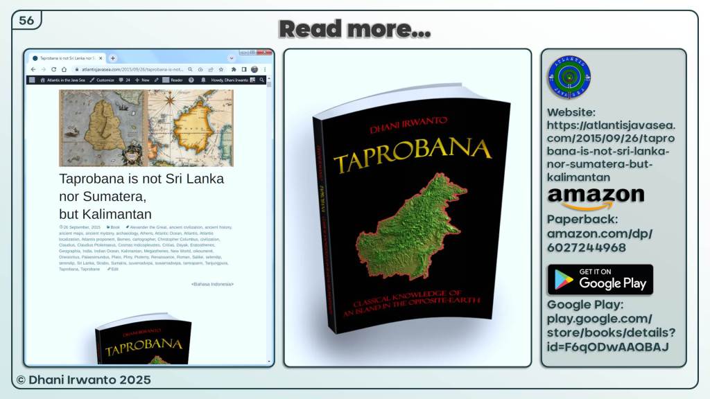
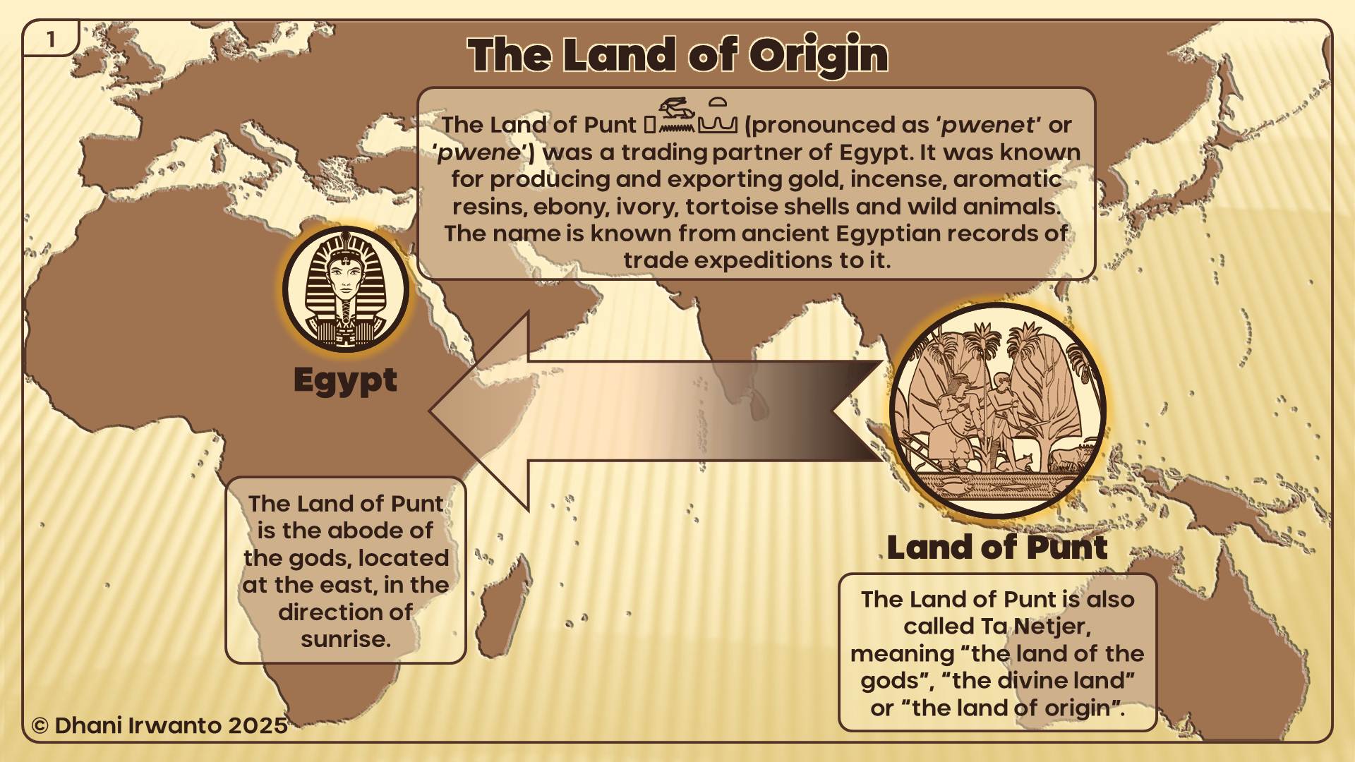
Dhani Irwanto is the author of the books "Atlantis: The Lost City is in Java Sea" (2015), "Atlantis: Kota yang Hilang Ada di Laut Jawa" (2016), "Sundaland: Tracing the Cradle of Civilizations" (2019), Land of Punt: In Search of the Divine Land of the Egyptians (2019) and Taprobana: Classical Knowledge of an Island in the Opposite-Earth (2019).
Dhani Irwanto was born in Yogyakarta, Indonesia in 1962. He is currently an owner and director of a consulting firm located in Bogor, West Java, Indonesia.
View all posts by Dhani Irwanto →
This article synthesizes Plato’s narrative in Timaeus–Critias with modern earth-science processes. It proposes a two-phase catastrophe model—an instant devastation followed by long-term subsidence—and clarifies the dual timeline: the age of Atlantis versus Solon’s “now.”
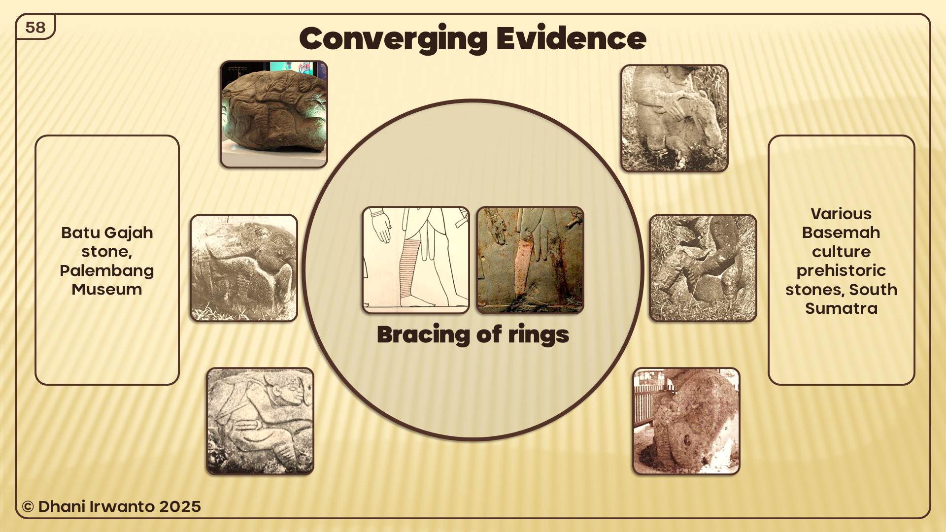
1. A Two-Phase Catastrophe Model
Phase 1 — The Instant Devastation (Tsunami & Quake)
Textual anchors: “violent earthquakes and floods; and in a single day and night of misfortune… the island of Atlantis… disappeared into the depths of the sea.” (Timaeus 25c–d). Critias recalls the same blow as “the greatest of the deeds… which a single stroke of fortune wiped out” (Critias 108e) and the “cataclysm which devastated” the Athens and Atlantis (Critias 112a).
Modern analog: a large offshore earthquake triggers extreme ground-shaking and a basin-scale tsunami. Minutes to hours bring lethal inundation, building collapse, coastal scour, and abrupt cultural termination—matching Plato’s “single day and night” formulation.
Phase 2 — The Slow Sinking (Subsidence & Shoaling)
Philology. Plato’s clause at Timaeus 25d: πηλοῦ κάρτα βραχέος ἐμποδὼν ὄντος, ὃν ἡ νῆσος ἱζομένη παρέσχετο. Conservative sense: “a very shallow shoal (of mud) standing in the way, which the settling island furnished.” The wording denotes an extremely shallow navigational impediment; it does not, by itself, fix the material genesis.
Geology/geomorphology. After a megaquake, the crust can continue adjusting for years to centuries. Coastal plains compact; deltaic clays dewater; faulted margins creep—incremental subsidence that deepens water over ruins and progressively establishes near-surface shoaling.
Carbonate settings. In warm, clear, well-circulated tropical waters, biogenic carbonate (including corals) can accrete over centuries–millennia, mantling and maintaining a near-surface obstruction (“reef‑mantled, near‑surface shoal”) consistent with the conservative phrasing.
Navigation & bathymetry implications:
Labyrinths of shoals and patch highs strand low-draft hulls; oars and rudders can foul in unconsolidated substrates.
Depth, swell, light attenuation, and lack of optical aids limit effective underwater search for ancient mariners.
Ancient pilots would justifiably brand such waters “impassable” (Timaeus 25d; Critias 111b).
2. Dual Timeline Alignment in Plato’s Narrative
Plato alternates between the remote past (Atlantis’ zenith and its sudden demise) and the narrators’ present—really Solon’s present as reported by Egyptian priests and re‑narrated by Critias. Markers like νῦν (“now”) and “to this day” describe present‑tense conditions contrasting with the mythic past.
Timeline
Keywords/Greek
Representative Passages
What It Describes
Past — Atlantis’ glory & sudden devastation
σεισμοί (earthquakes), κατακλυσμοί (floods)
Timaeus 25c–d; Critias 108e; 112a
One‑day apocalyptic event: quake‑tsunami destroying population, structures, and power.
Aftermath observed “to this day”: impassable, very shallow shoal (of mud) furnished by the settling island; often reef‑mantled in the long run.
Representative Passages (with clause numbers)
Timaeus 25c–d: “Violent earthquakes and floods… and in a single day and night of misfortune… the island of Atlantis… disappeared into the depths of the sea. Therefore even now (διὸ καὶ νῦν) the sea at that place is impassable and unsearchable, blocked by a very shallow shoal (of mud) which the settling island furnished.”
Critias 108e: “…the greatest of the deeds of your city, which a single stroke of fortune wiped out.”
Critias 111b–c: “…for which reason the sea to this day is impassable and unsearchable, being blocked by the shallowness of the mud which the island created as it settled… …what is now (νῦν) called ‘stony’ (phelleus) was then fertile…”
3) Cross-Disciplinary Notes (Quick Reference)
Philology
ἵζω/ἵζομαι — “to seat; to settle; to sink down.” Hence ἱζομένη/ἱζοῦσα used by Plato for continuing settlement/subsidence.
πηλός — mud/clay; βραχύτης/βραχέος — shallowness/“shallow”; ἐμποδών — “in the way, as an impediment.”
Conservative clause-level gloss: “a very shallow shoal (of mud) standing in the way, which the settling island furnished.”
Geology & Geomorphology
Instant devastation from quake–tsunami, followed by post‑seismic deformation, compaction, and slope failures.
Within the Holocene transgression, progressive near‑surface shoaling may persist; in carbonate provinces, reef/carbonate accretion can keep obstructions close to the surface.
Marine Ecology & Carbonates
Coral and other carbonate producers thrive in clear, well‑circulated, well‑lit waters; over time they can mantle and maintain near‑surface shoals.
Archaeology
Expect a time‑transgressive stack: cultural layers truncated by tsunami, overlain by marine sediments, later mantled by biogenic carbonates.
Closing Synthesis
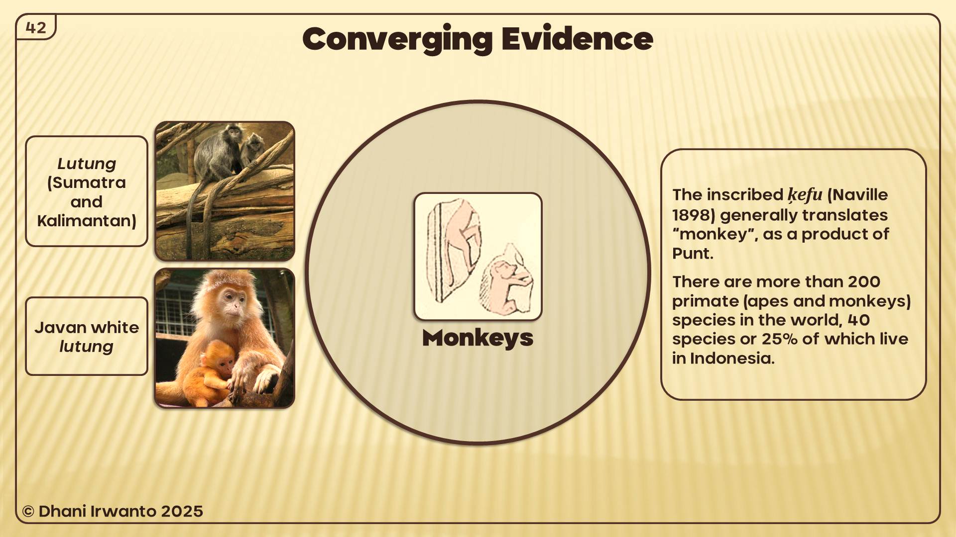
Plato’s narrative signals both a one‑day cataclysm and a centuries‑scale aftermath: the event ends a civilization; the process leaves a ship‑stopping, very shallow shoal “of mud,” often later reef‑mantled in suitable settings.
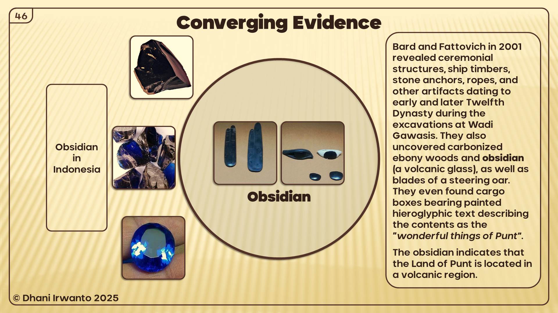
Notes & References
Primary texts: Plato, Timaeus and Critias (Stephanus 25c–d; 108e; 111b–c; 112a). Clause numbers are stable across editions. Greek phrases are quoted for precision; translations are intentionally conservative at clause level.
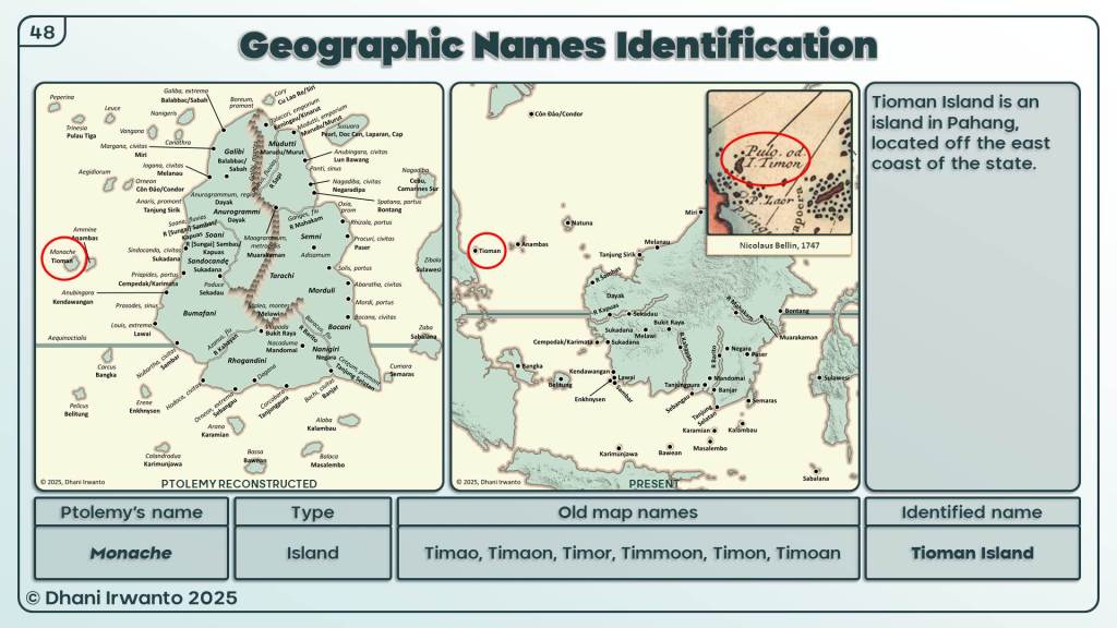
A research by Dhani Irwanto, 2 September 2025, addendum 4 September 2025
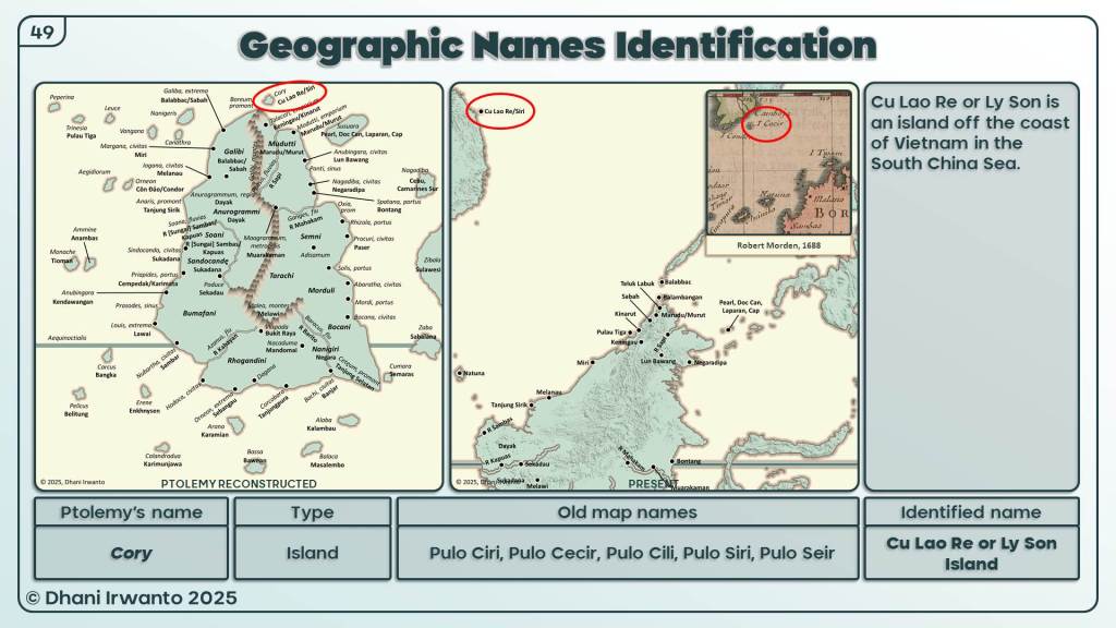
Abstract
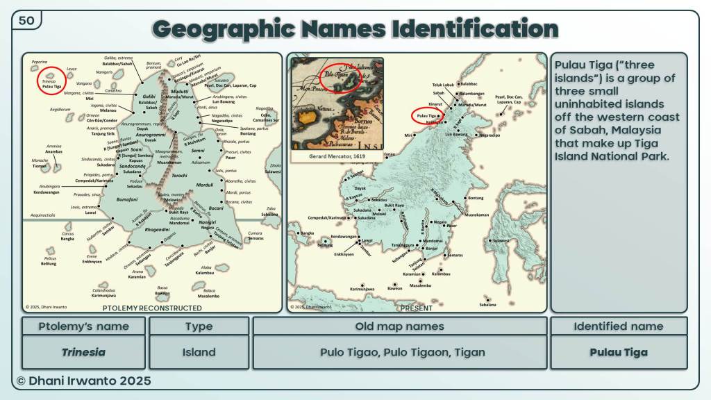
This article re-examines Plato’s clause πηλοῦ κάρτα βραχέος ἐμποδών ὄντος, ὃν ἡ νῆσος ἱζομένη παρέσχετο (Timaeus 25d). We retain a conservative rendering: “a very shallow, ship-stopping shoal of mud/clay/silt, which the island provided as it settled.” Classical Greek lacks a fixed idiom for the modern technical term “coral reef,” so the phrase is treated as a context clue that secures the navigational effect but leaves the sustaining mechanism unspecified.
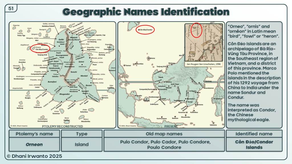
A marine-geological challenge follows from a literal, long-term “mud shoal” reading. Formation: in the absence of a local, continuous source of fine sediment (e.g., a river plume, estuary, or engineered spoil), an offshore shoal of mud/clay/silt lacks the supply and hydrodynamic confinement needed to aggrade upward toward the water surface; wave-orbital shear over a positive relief winnows fines, preventing vertical build-up to crest depth. Persistence: even if a storm or flood briefly raises a muddy mound, on open shelves such features are typically mobile and short-lived—reworked by waves and currents, reshaped by storms, and redistributed by river plumes—and, under post-glacial sea-level rise with slow subsidence (~1 cm/yr), they are not expected to maintain a stable, near-surface crest that reliably stops ships. Language alone (and a purely muddy material term) therefore cannot settle how the obstruction both formed and endured.
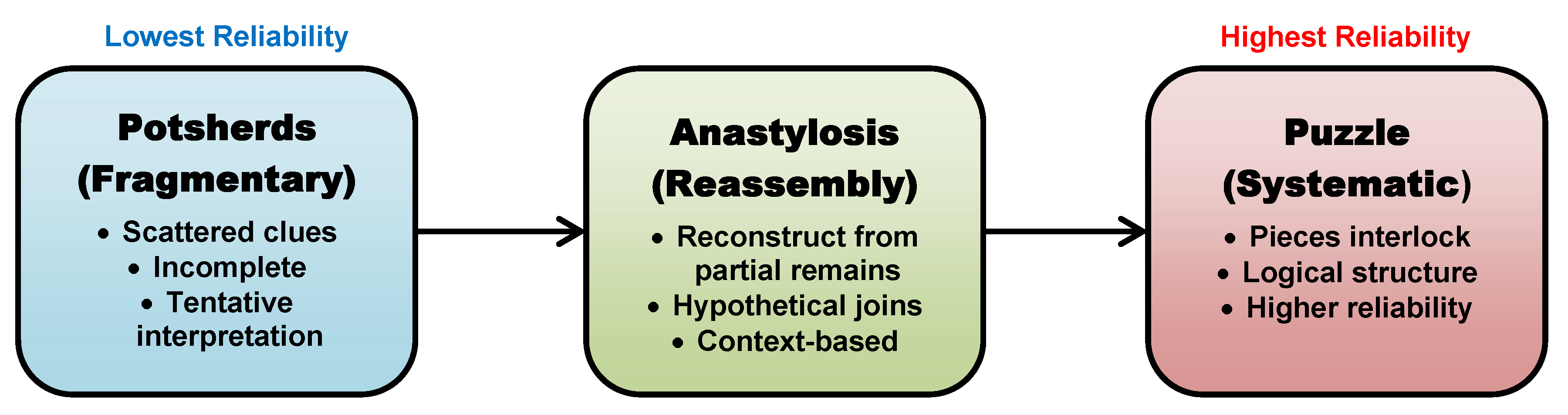
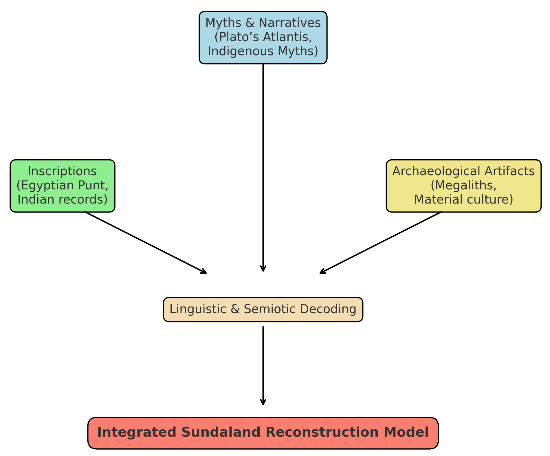
We therefore apply a semiotic–philological program that escalates from denotation and language-internal tests to a third-order assembly-and-consilience evaluation. Independent “puzzle pieces”—text/philology, pilotage and placement inside the mouth, geomorphology (planform), bathymetry (depth architecture), and regional ecology (growth potential)—are assembled and tested for mutual fit without ad-hoc rescue.
At Order-2, the language-internal analysis points to a reef-mantled (coral-reef) shoal as the best interpretation of the clause—while the translation itself remains conservative (“a very shallow, ship-stopping shoal of mud/clay/silt”). At Order-3, assembling the independent “puzzle pieces” and testing them by consilience identifies the specific fit with the Gosong Gia coral reef (Java Sea) over the sunken capital-island, yielding the remembered condition of impassability in Solon’s time. The contribution is twofold: a conservative translation coupled with a meaning established first by Order-2 inference and then confirmed by Order-3 consilience within the full reconstruction.
1. Problem Definition — What Does πηλοῦ κάρτα βραχέος Mean?
Syntactic note. Genitive absolute with a relative clause whose antecedent is the obstructive shoal; the island is the grammatical subject that “provided” it while settling.
1.2 Linguistic gap and ambiguity
Classical Greek lacks a single, fixed idiom corresponding to the modern technical term “coral reef.” The clause names the navigational effect (a very shallow, ship-stopping shoal with muddy character) but does not specify the long-term mechanism that keeps such an obstruction at crest depth.
1.3 Timeline tension in the narrative
The texts distinguish (i) a catastrophic destruction (“in a single grievous day and night,” Timaeus 25c) from (ii) a later state of impassability associated with settling/sinking (Timaeus 25d) and with the worked seascape around the capital-island (Critias 111a–c, 112a). The problem includes determining to which timeframe the persistent shallowness belongs and what processes could have produced that later condition.
1.4 Marine-geological challenge
Formation. On open marine shelves, building a near-surface mud/clay/silt mound requires a proximate, continuous source of fines (e.g., river plume, estuary, dredge spoil) and hydrodynamic confinement. In the absence of such input and trapping, wave-orbital shear over positive relief winnows fines and prevents upward aggradation toward the water surface.
Persistence. Even if storms or floods temporarily raise a muddy mound, unconsolidated fine-sediment shoals are typically mobile and short-lived: they are reworked by waves and currents, reshaped by storms, and redistributed by river plumes. Under post-glacial sea-level rise with slow subsidence (≈ 1 cm/year), gradual vertical drowning would not maintain a perpetual, turbulent, muddy shoal fixed near the surface. Without extraordinary confinement and continuous fine-sediment supply, fines are winnowed and dispersed, making a long-lived, ship-stopping mud crest geologically implausible.
1.5 The concrete problems to resolve
Formation. Without a proximate, continuous source of fines and hydrodynamic confinement, how could a mud/clay/silt mound aggrade upward to approach the water surface in the first place?
Persistence. Under post-glacial sea-level rise with slow subsidence (~1 cm/yr), how could a near-surface crest be maintained for centuries–millennia rather than being winnowed and dispersed?
Material vs. function. Can the clause’s muddy description be reconciled with a durable near-surface obstruction, or does a different material/process better account for the ship-stopping effect?
Temporal placement. How do the catastrophic destruction and the later impassability relate, and which processes govern the later condition?
Geographical fit. Does any proposed mechanism coherently match the capital-island setting and the navigational effect implied by the clause?
2. Methods — How the Phrase is Analyzed
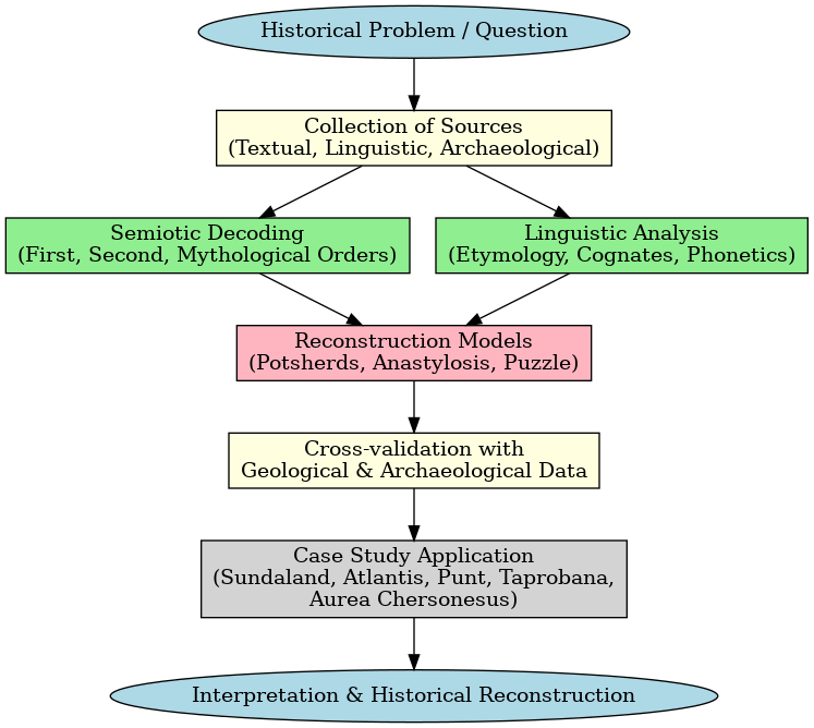
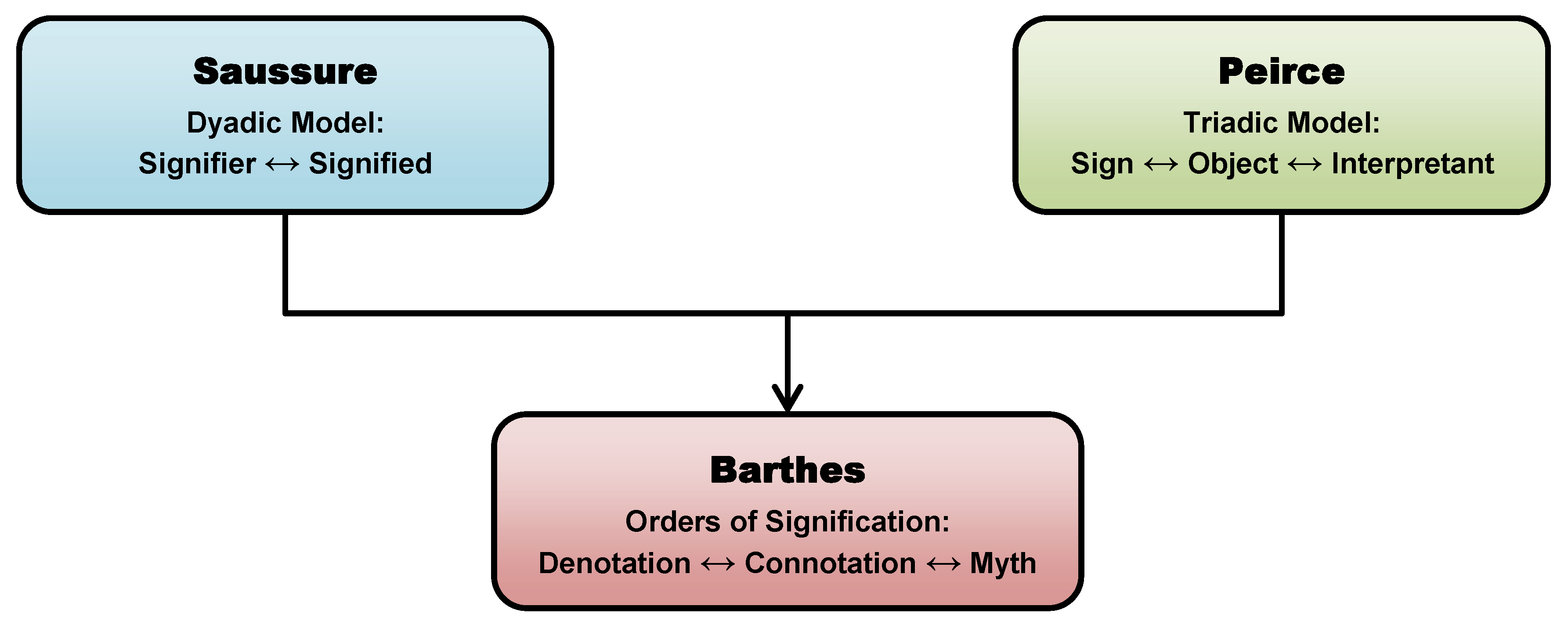
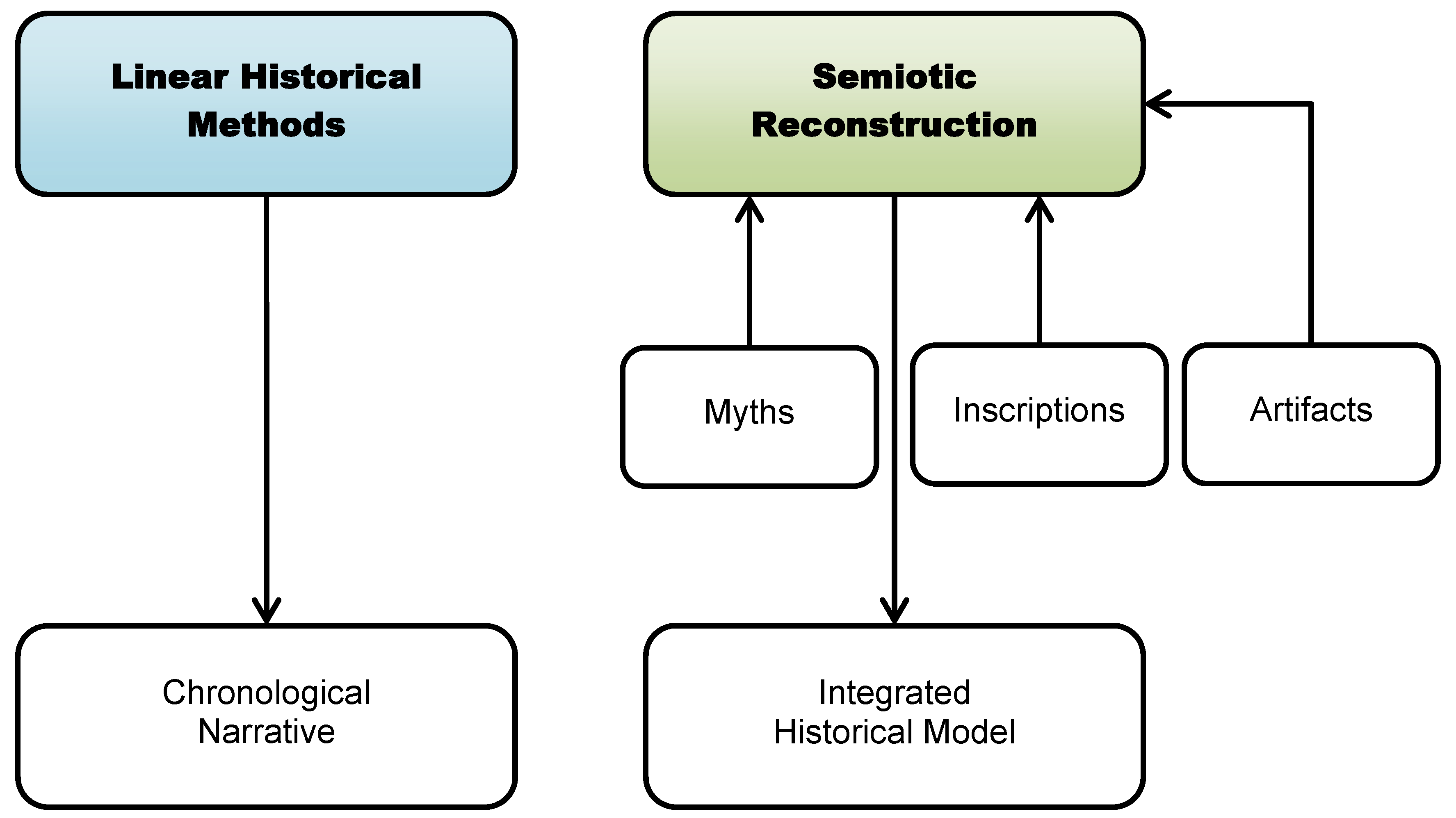
This study combines semiotics (main method), linguistics/semantics, language-structure tests, philology, and archaeology/history under a consilience framework. The goal is to move from sign to meaning without anachronism and to make the claim falsifiable against independent evidence.
2.1 Semiotics (Main Method)
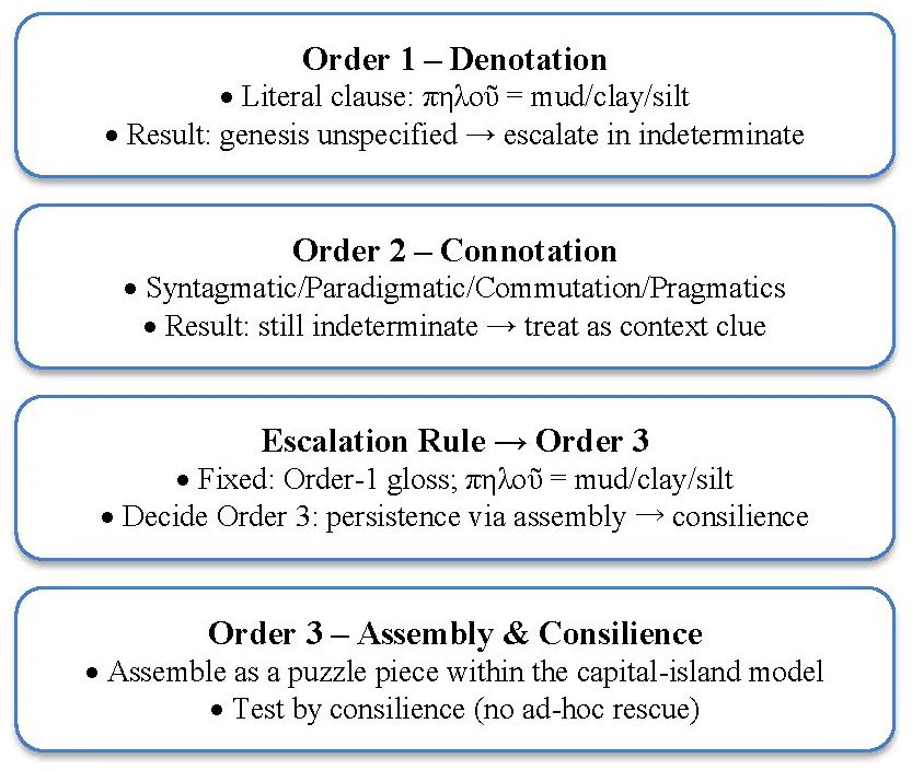
We treat πηλοῦ κάρτα βραχέος as a sign and test its meaning by ordered steps: Saussure’s dyad (signifier ↔ signified), Peirce’s triad (sign–object–interpretant), and especially Barthes’ orders of signification (the most important layer for this paper). At third order we embed the sign in a full reconstruction—the Puzzle/Anastylosis/Potsherd Models—and test whether it locks with independent evidence without ad-hoc fixes⁴.
Order 1 — Denotation: parse the clause in context; ask whether the literal sense uniquely determines the referent.
Order 2 — Connotation: apply language-internal contrasts (syntagmatic, paradigmatic, commutation) and pragmatics; if still indeterminate, escalate.
Order 3 — Reconstruction & consilience: assemble the sign with other puzzle pieces (capital-island inside the mouth3, Gosong Gia, regional reef ecology, bathymetry); accept provisionally only if the pieces cohere without contradiction.
2.2 Linguistics (Semantics & Context Clues)
Semantics provides tools to infer meaning from usage and co-text. A context clue is a piece of information provided by an author within a text to help readers understand the meaning of an unfamiliar or difficult word/phrase. In this study, the phrase πηλοῦ κάρτα βραχέος itself functions as that context clue—transmitted from the Egyptian priest to Solon, Critias, and Plato—guiding readers toward the kind of near-surface obstruction encountered at the capital-island inside the mouth³.
2.3 Applications to Language
We apply four language-structure checks: Syntagmatic — how elements combine inside the clause (e.g., intensifier κάρτα + qualitative genitive βραχέος narrows the hazard to extreme shallowness). Paradigmatic — the contrast set Plato did not choose (e.g., ὕφαλος ‘reef’, βράχεα ‘shallows’). Commutation test — substitute those terms and assess whether the discourse function changes (does the clause cease to match the narrative constraints?). Pragmatics — speaker intention and audience effect in a nautical description: to warn that a formerly accessible capital-island became unreachable from the sea after being mantled by reef.
2.4 Philology (Text, Variants, Syntax)
Close reading establishes the grammatical scaffold: a genitive absolute; adverbial ἐμποδών; qualitative genitive κάρτα βραχέος; relative pronoun with the shoal as antecedent; ἡ νῆσος as subject; participle ἱζομένη (“settling”); and παρέσχετο (“produced/furnished”). We also distinguish the adverbial expression κατὰ βραχύ (“briefly”) from the phrase under study; the former is unrelated.
2.5 Archaeology/History (Consilience Framework)
We require independent lines to converge without ad-hoc rescue. Five evidence classes are used: textual-philological, navigation/toponymy, geomorphology, bathymetry, and regional ecology.
These methods define the escalation rule used in §3: if Orders 1 – 2 fail to identify a specific referent without anachronism, we escalate to Order 3 where the phrase is assembled with other puzzle pieces and tested by consilience.
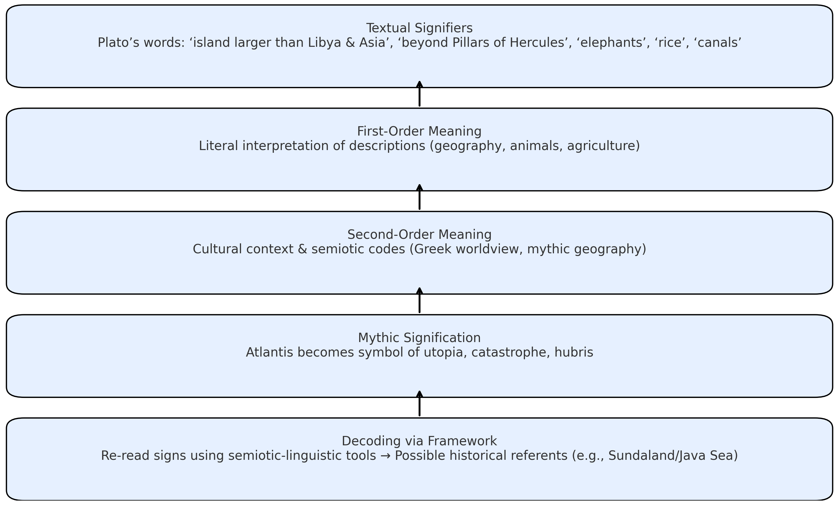
3. Problem‑solving Workflow — Orders of Signification
We resolve the meaning of the sign by passing it through three ordered levels. If lower levels fail to identify a specific referent without anachronism, the phrase is escalated and then tested inside the full third-order reconstruction of the capital-island.
Conservative parsing and sense. At the denotative level, πηλοῦ is taken in its ordinary material sense—“mud, clay, or silt.” The intensifier κάρτα (“very”) with βραχέος (“shallow”) marks extreme shallowness; ἐμποδών indicates a navigational impediment (“in the way”); the relative clause ties the obstruction to the island’s settling (ἱζομένη). A cautious Order-1 gloss is therefore: “a very shallow, ship-stopping shoal of mud/clay/silt, which the island provided as it settled.” Order-1 thus fixes the effect (a hazardous shoal) and the proximate linkage (to settling), while remaining agnostic about the long-term mechanism that maintained the hazard.
Formation problem at Order-1 (marine-geological setting). The wording depicts what the feature behaved like, but not how such a muddy shoal could form up toward the surface in the first place where no local, continuous fine-sediment input (river plume/estuary/spoil) and no hydrodynamic confinement are evident. Over positive relief, wave-orbital shear winnows fines, inhibiting upward aggradation to crest depth (see §6.2).
Why Order-1 is insufficient on persistence. Even if storms or floods temporarily raise a muddy mound, unconsolidated mud/clay/silt shoals on open shelves are typically mobile and short-lived: they are reworked by waves and currents, reshaped by storms, and redistributed by river plumes. Over century-to-millennium timescales—especially under post-glacial sea-level rise—such fine-sediment shoals do not typically hold a fixed, near-surface crest that reliably stops ships (see §6.2).
Phase-2 slow-subsidence context (cf. §6.4). In the later scenario discussed in §6.4, the landmass is envisaged as sinking slowly under post-glacial sea-level rise, on the order of ~1 cm/year in generic terms. Such gradual vertical drowning would not create or maintain a perpetual, turbulent, muddy shoal at crest depth: the increasing water column and persistent orbital shear at the top of a shoal would winnow and disperse fines unless extraordinary confinement and continuous supply were present.
Interim conclusion at Order-1. Order-1 yields a conservative translation and a clear functional profile (“very shallow, ship-stopping shoal”), but—given the general marine-geological dynamics (formation and persistence; §6.2) and the Phase-2 slow-subsidence context (§6.4)—it does not by itself identify the enduring mechanism that kept the crest near the surface. This motivates escalation to Order-2 (language-internal tests) and, if still indeterminate, to Order-3 (assembly & consilience), without redefining πηλοῦ.
Philological note on the relative clause. The wording ὃν ἡ νῆσος ἱζομένη παρέσχετο encodes processual causation: as the island was settling, it “furnished” the obstruction. The Greek thereby links the hazard to submergence, but leaves the mechanism/material underspecified (no term for “growth” or “reef” is used, and no depth is given).
3.2 Order 2 — Connotation & Language-Internal Tests
Aim. Without importing external geology, Order-2 asks what the Greek itself allows or excludes when we probe usage, composition, contrasts, and speaker intent.
(a) Syntagmatic composition (how the clause is built). The intensifier κάρτα (“very”) with βραχέος (“shallow”) maximizes thinness; ἐμποδών specifies navigational interference; the genitive-absolute with ἱζομένη (“settling”) ties the impediment to an ongoing process associated with the island. Read together, the syntax profiles a very shallow, ship-stopping feature whose appearance is linked to settling, not a mere descriptive aside.
(b) Paradigmatic contrast (what Plato did not say). If a rock- or reef-type hazard were the intended denotative label, Greek offered other lexical resources (e.g., terms for rocks/ledges, or “under-sea/reef-like” hazards) and also familiar shore/bar words (sandbanks, marsh, etc.). Instead, the text uses πηλοῦ—the ordinary word for mud/clay/silt—plus a strong shallow/impeding profile. This choice underscores the effect (dangerous thinness that stops ships) and a muddy quality, while not elevating any technical seafaring noun to name the mechanism.
(c) Commutation test (controlled substitutions). If we substitute the material noun in thought experiments: swap πηλοῦ for “sand” → the picture shifts toward a sandbar/beach bar; swap for “rock/ledge/reef” → it becomes a rocky sill/reef; swap for “marsh/weed” → it evokes a vegetated shoal. These substitutions change the mechanism each time. Plato’s actual choice—πηλοῦ—colors the hazard as muddy while keeping the core function (impediment) intact; it does not by itself decide how a near-surface obstruction formed or persisted over time.
(d) Pragmatics (who is speaking to whom, and to what end). Within the narrative, a non-technical report passes through cultural and temporal filters (Egyptian priest → Solon → Critias → Plato). The phrasing works as a context clue: it helps a general audience imagine a ship-stopping shallowness caused as the island “settled,” without presuming a specialist taxonomy. The subject (“the island”) in the relative clause further frames the process as natural rather than engineered.
Because Classical Greek lacked a fixed idiom for ‘coral reef,’ the clause can be heard through a familiar craft schema—mud that ends up ‘hardened’ into a ship-stopping obstacle—while the translation of πηλοῦ remains conservative; ‘reef’ is the Order-2 interpretation subsequently tested at Order-3.
Interim result at Order-2. Language-internal tests indicate that the clause functions as a context clue to a persistent, near-surface, accreting shoal; among live mechanisms, a reef-mantled (coral-reef) shoal best fits the wording and contrasts without redefining πηλοῦ in translation. Thus, Order-2 yields the working interpretation “coral reef.” Order-3 then tests this interpretation by consilience within the full reconstruction.
3.3 Escalation Rule
Why escalate. Orders 1 – 2 establish a stable functional profile—a very shallow, ship-stopping shoal linked to settling—but they remain agnostic about the long-term mechanism that could keep the crest near the surface.
What stays fixed; what is decided at Order-3.
Fixed (translation policy): retain the Order-1 gloss — “a very shallow, ship-stopping shoal of mud/clay/silt, which the island provided as it settled.” (πηλοῦ remains “mud/clay/silt”).
To be decided (Order-3): how such a shoal could persist at near-surface crest depth through time (mechanism + time-behavior) — specifically by assembling the independent “puzzle pieces” in a Puzzle Model⁴ and then testing that assembly by consilience (see §3.4), against the general marine-geologic background (§6.2) and the Phase-2 slow-subsidence context (~1 cm/yr) (§6.4), without redefining πηλοῦ.
Hand-off to §3.4. Section 3.4 now performs that puzzle assembly → consilience test, using the independent constraints to evaluate which mechanism best accounts for a persistently near-surface, ship-stopping shoal, while the conservative translation from Order-1 remains intact.
3.4 Order 3 — Assembly & Consilience
At this level the clause is integrated as a puzzle piece within the whole third-order model: (i) tropical constraint at ~11,600 BP; (ii) global narrowing to Sundaland; (iii) Sundaland envelope with the ancient Java Sea and the eastern “mouths” (e.g., Kangean Mouth); (iv) sea level ~–60 m at ~11,600 BP; (v) the South-Kalimantan level plain and canals; (vi) placement of the capital-island inside the mouth; (vii) Gosong Gia as a reef-mantled high; (viii) city form and multibeam/bathymetry benchmarks (see Figures 3 – 9). The pilotage sequence (outer sea → mouth → inner sea → local canal → ringed salt-water basins, with the last three on the capital-island) is one component inside this whole. The test is consilience: do these independent lines lock together without contradiction?
3.5 Application in This Study
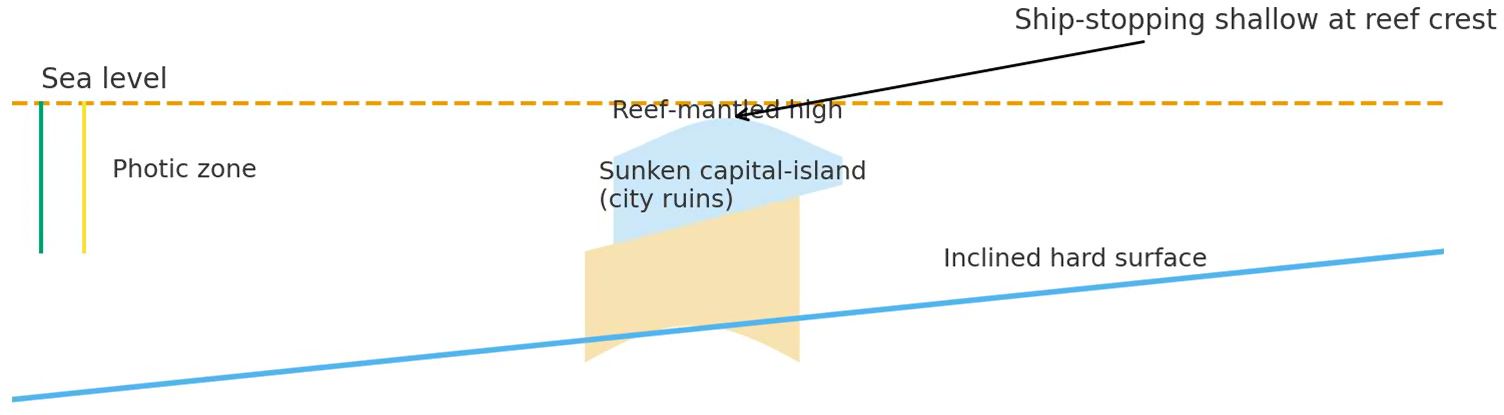
πηλοῦ κάρτα βραχέος advances to Order 3 because Orders 1 – 2 remain indeterminate. In assembly it behaves like a reef-mantled, near-surface shoal over the sunken capital-island, making the city’s ruins impassable from the sea while satisfying the constraints summarized in Figures 3 – 9.
Figure 2. Reef-mantled obstruction over the sunken capital-island (schematic cross-section).
4) Assembly at Third Order — Puzzle Pieces & Consilience Tests
At the third order, the phrase is treated as a puzzle piece and tested within the whole reconstruction of the capital-island. The independent pieces below must lock together without ad-hoc rescue; where they do, the reading is provisionally supported.
4.1 Tropical Constraint (~11,600 BP)
Global vegetation at ~11,600 BP places the target in the tropical belt. Non‑tropical settings fail the primary biogeographic screen for extensive carbonate factories. See Figure 3.
Figure 3. Global vegetation at ~11,600 BP; tropical belt highlighted. Source: author’s compilation after standard palaeovegetation maps.
4.2 Global Narrowing to Sundaland
Intersecting Plato’s areal claim, the presence of neighboring islands and an opposite continent, and biocultural markers (e.g., coconut, elephant, rice) converges on Southeast Asia/Sundaland. See Figure 4.
Figure 4. World map at ~11,600 BP with converging markers; Sundaland emphasized. Source: author’s reconstruction.
4.3 Sundaland Envelope: Enclosed Sea, Eastern “Mouths,” Mountains, and Sea Level (~–60 m)
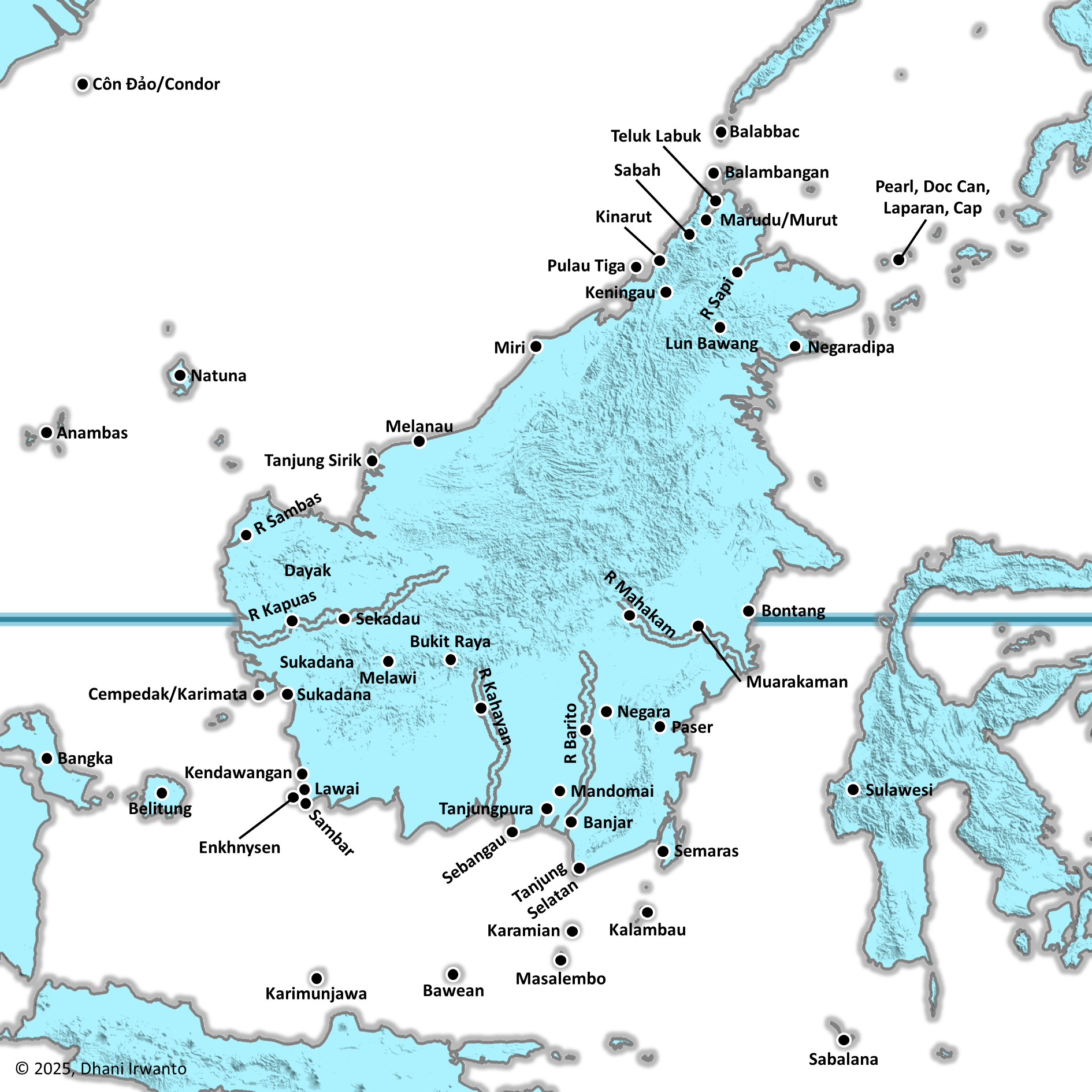
The ancient Java Sea forms an enclosed sea bounded by continent-scale land, with clustered eastern mouths (e.g., Kangean Mouth) providing access from the oceanic side. A volcanic-arc mountain chain lines the oceanic margin. Relative sea level near ~–60 m at ~11,600 BP frames shelf exposure and subsequent drowning. See Figure 5.
Figure 5. Sundaland and the ancient Java Sea: enclosed sea, eastern mouths, mountain arc; shoreline ~–60 m. Source: author’s reconstruction.
4.4 Level plain & canals (South Kalimantan); placement of the capital‑island
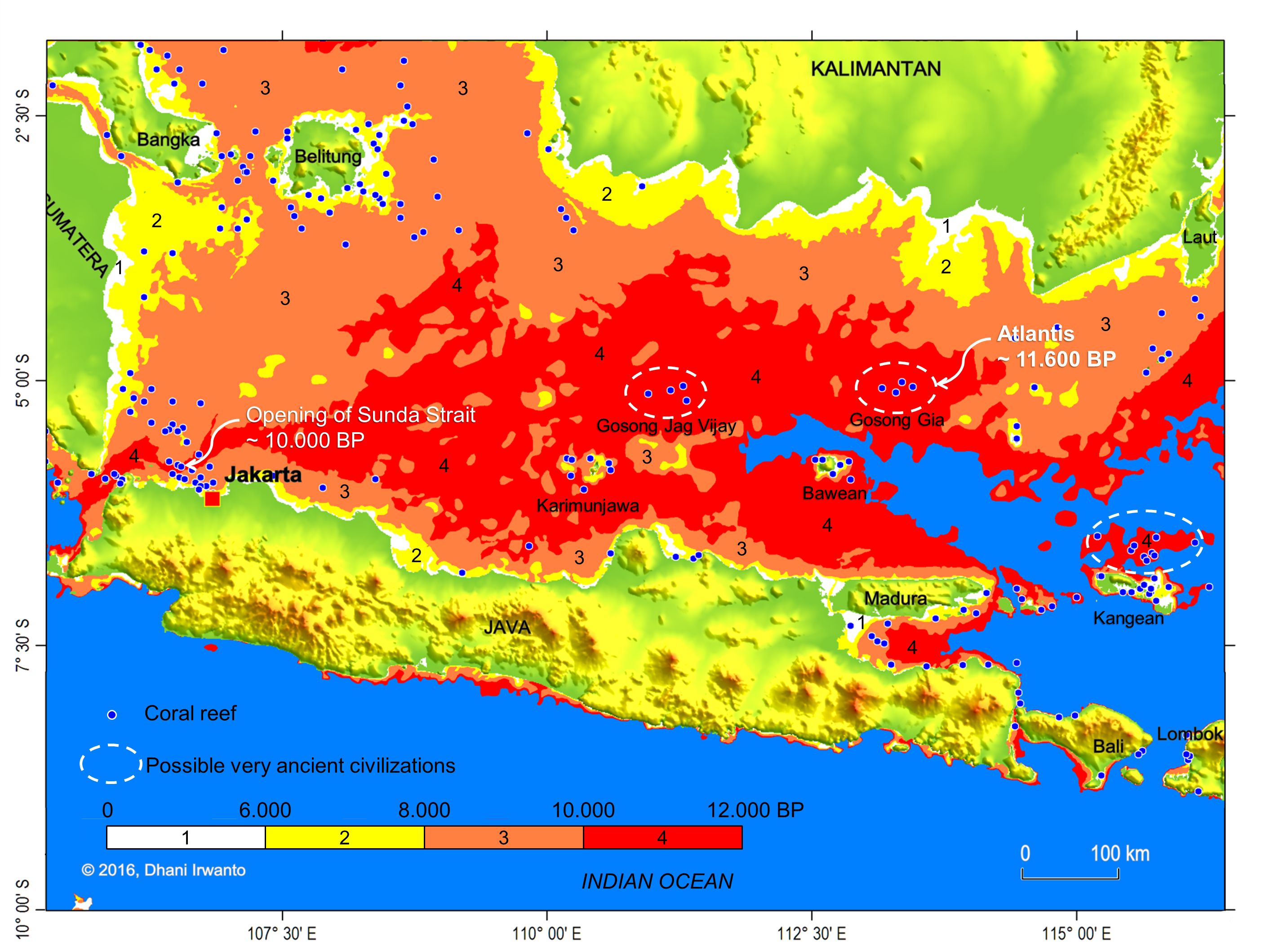
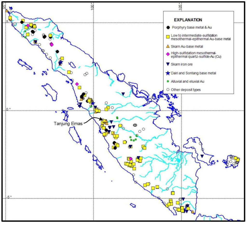
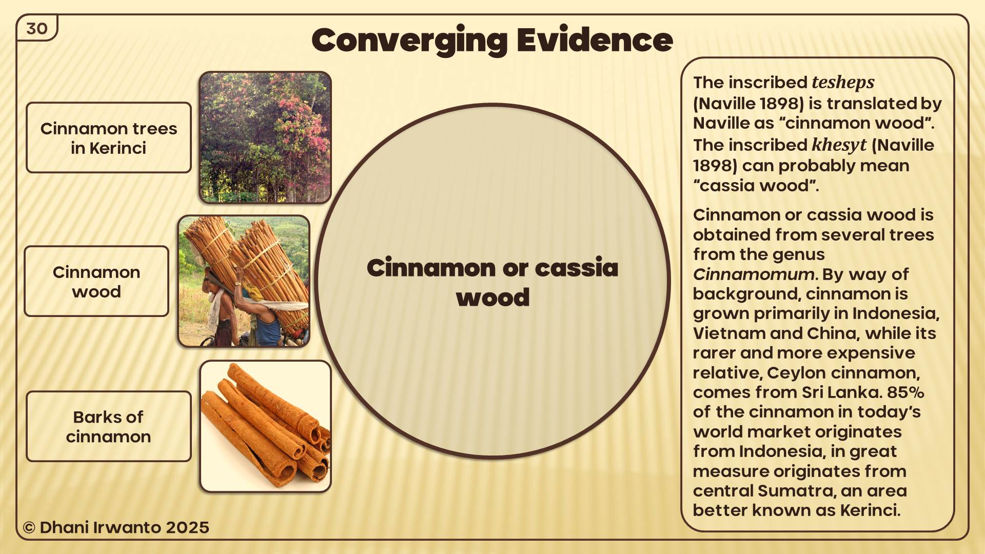
South Kalimantan presents a square-oblong level plain (≈ 555 × 370 km) open to the sea at the south and sheltered at the north, with major, transverse, and irrigation canals. The capital-island is placed on an island inside the mouth, located at the south side of the plain, consistent with the pilotage sequence (outer sea → mouth → inner sea → local canal → ringed salt-water basins)3. See Figure 6.
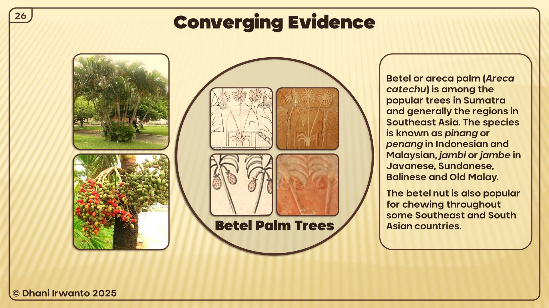
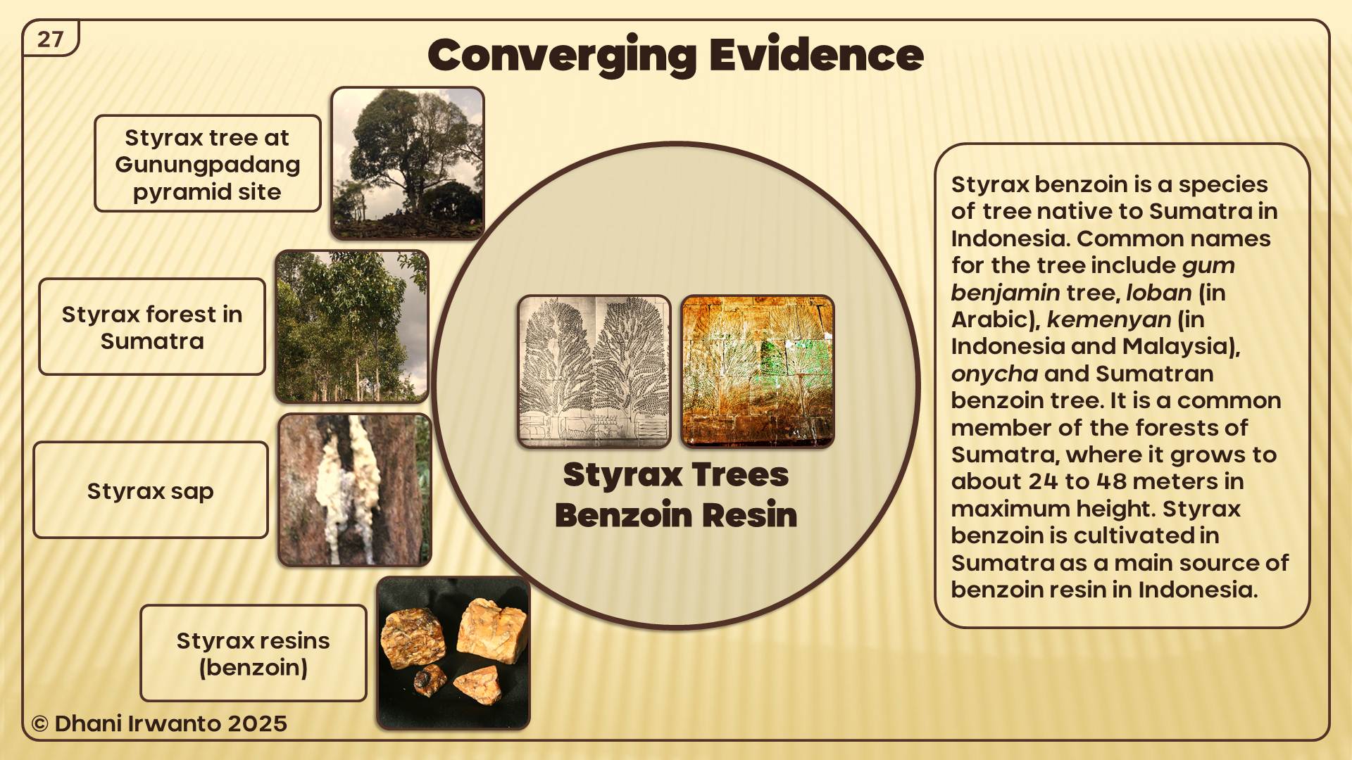
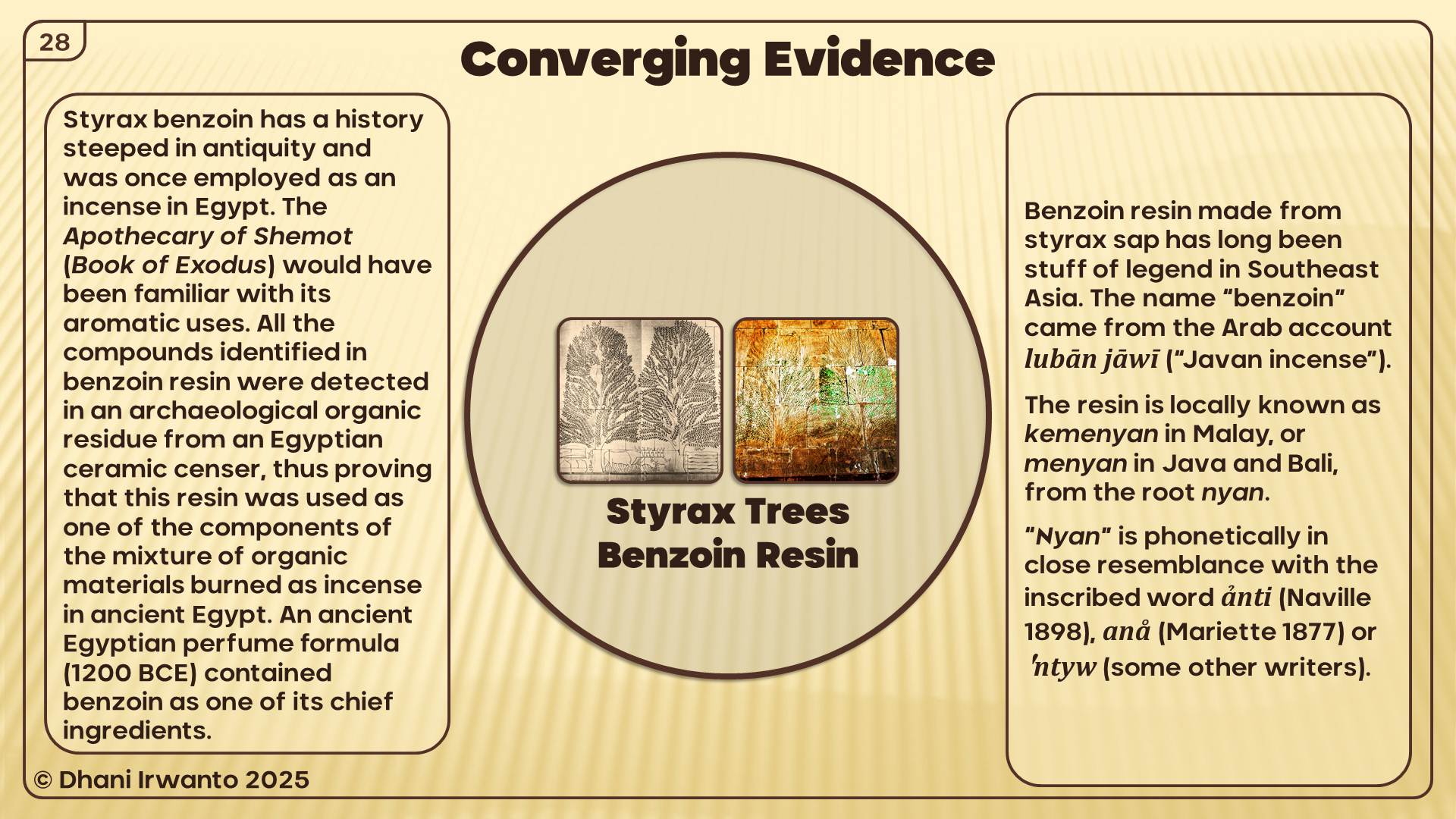
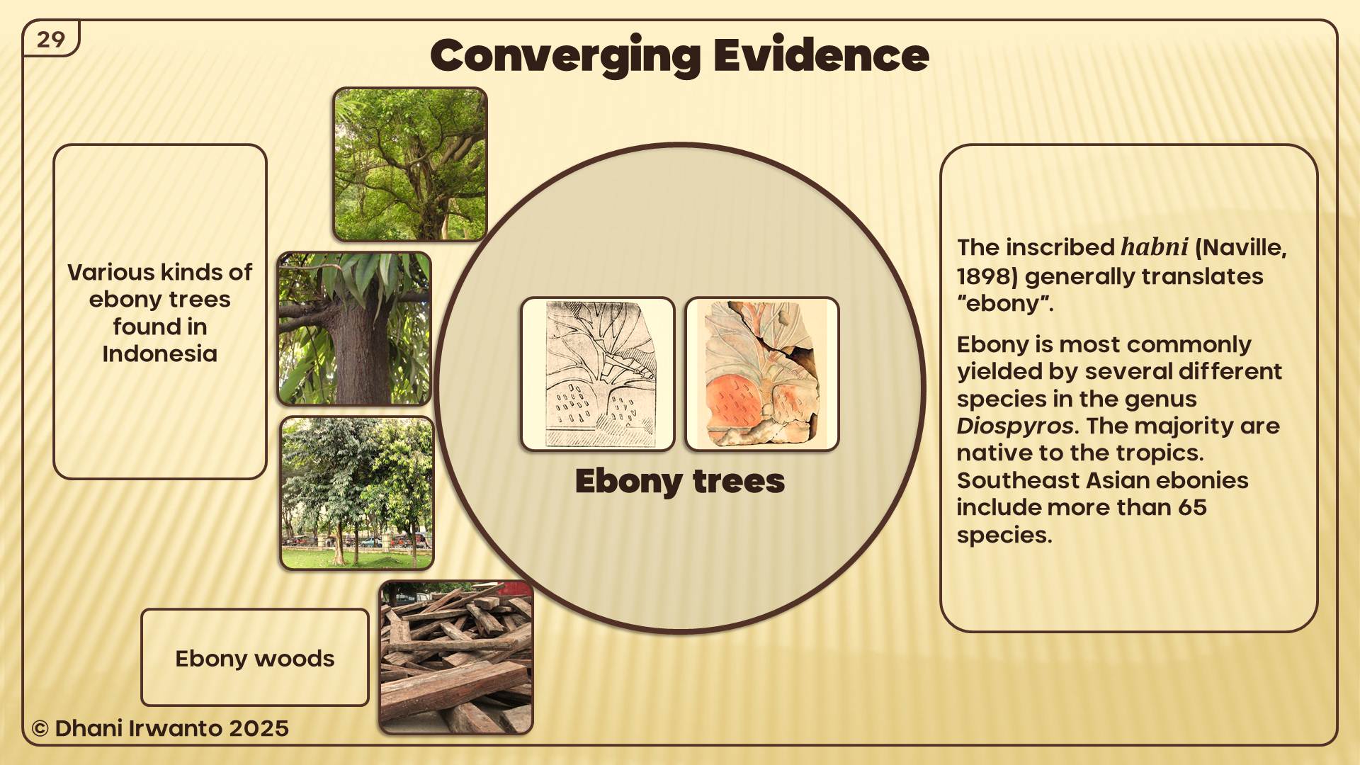
Figure 6. South Kalimantan level plain & canals; placement of the capital‑island inside the mouth. Figure 7. Coral-reef distribution in the Java Sea (from Irwanto 2015).12
4.5 City Form on the Capital‑island (Ringed Salt‑water Basins)
The capital-island exhibits concentric rings of water and land, bridges/underpasses, and a palace/temple on a small hill near the center—a functional harboring system matching Plato’s narrative constraints for access and defense. See Figure 8.
Figure 8. Conceptual rendering of the ringed capital-island: water/land rings, bridges, and central sanctuary. Source: author’s reconstruction.
4.6 Benchmarks at Gosong Gia (Reef‑mantled High)
Multibeam/bathymetric evidence at Gosong Gia shows a central knoll and an annular trough at ~55 – 60 m, matching (1) late-glacial stillstands ~11,600 BP, (2) the ringed-city geometry and (3) a small hill near the center as benchmarks to assemble other puzzle pieces. The pattern is consistent with a reef-mantled high whose carbonate production maintained near-surface obstruction. See Figure 9.
Figure 9. City plan vs. Gosong Gia bathymetry: central knoll, annular trough ~55 – 60 m and three benchmarks. Source: author’s comparison.
4.7 Fit Statement & Decision Rule
Fit statement (assembly result). The Order-3 assembly yields a single coherent object: the coral-reef–mantled shoal at Gosong Gia (Java Sea), located inside the mouth and over the sunken capital-island on the south side of the plain. This object reproduces the clause’s navigational effect (“very shallow… in the way”) as a persistent, near-surface hazard.
Consilience (constraint-by-constraint).
Locational/pilotage: aligns with the sequence outer sea → mouth → inner sea → local canal → ringed basins, at the approach to the capital-island.
Navigational: functions as a ship-stopping near-surface shoal across time, matching the remembered impassability.
Geomorphology: exhibits an annular reef planform with a central knoll, consistent with the capital-island geometry.
Bathymetry: shows ~60 m vertical relief from seabed to near-surface crest—adequate to present a crest-depth hazard without ad-hoc assumptions.
Ecology/growth: warm, sunlit conditions compatible with Holocene reef accretion (mm–cm/yr) capable of keeping pace with sea-level rise.
4.8 Counter‑explanations Tested
We evaluated non-reef mechanisms against the assembled pieces (formation, persistence, planform, bathymetry, ecology) and recorded the negative tests as follows:
H₀ — Persistent terrigenous silt/mud shoal (no reef mantle). Formation: lacks a proximate, continuous fine-sediment source and confinement to aggrade ~60 m toward the surface. Persistence: unconsolidated fines are winnowed and redistributed under waves/currents and cannot maintain a fixed, very-shallow crest through slow subsidence (~1 cm/yr). Status: Fails (formation & persistence).
H₁ — Sand bar/tidal-delta mound. Planform: expected elongate/migratory bars, not a stable annulus with central knoll. Depth behavior: shore-attached/migratory features do not produce the observed ~60 m relief to a near-surface crest offshore. Status: Fails (planform & bathymetry).
H₂ — Rocky sill/hardground without reef accretion. Time behavior: without vertical biogenic accretion, a rock high does not keep a crest at near-surface depth through Holocene rise. Ecology/texture: lacks the expected carbonate framework that explains both crest maintenance and surface roughness. Status: Fails (persistence & ecology).
H₃ — Anthropic obstruction (ruins or engineered bar). Scale: architectural debris cannot plausibly yield a regional annular bathymetry with ~60 m relief. Durability: does not explain the long-term near-surface crest without invoking ad-hoc confinement/supply. Status: Fails (scale & persistence).
H₄ — Transient flood/tsunami silting. Temporal mismatch: event deposits are episodic and remobilized, not a persistent ship-stopping shoal across centuries–millennia. Status: Fails (persistence).
Result. Each non-reef alternative contradicts ≥ 2 core classes (formation/persistence, planform, bathymetry, ecology) and/or relies on ad-hoc rescue (hidden confinement/continuous supply). The reef-mantled high at Gosong Gia remains the only mechanism that forms, keeps pace with sea-level rise, and matches the annular planform and near-surface crest—therefore it is provisionally supported pending direct material/chronometric checks.
5. Predictions & Measurement
This section turns the third-order assembly into falsifiable predictions and a measurement plan. Each evidence class yields concrete signals.
5.1 Testable Predictions by Evidence Class
Philology/Textual function: The clause behaves as a context clue for an unfamiliar phenomenon, not a taxonomic label; it remains compatible with a persistent, near-surface obstruction over the sunken capital-island.
Navigation/Toponymy: Modern mariners report a ship-stopping hazard at the site; historical charts/tags associate the feature with a shoal/reef that fits the pilotage sequence (outer sea → mouth → inner sea → local canal → ringed basins).
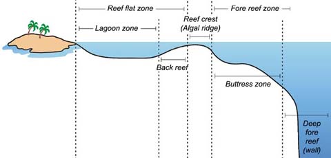
Geomorphology (planform): Annular or sub-annular planform with a small central knoll and surrounding trough, consistent with a reef-mantled high. Spatial coherence (crest → back-reef → lagoon/annulus) should be detectable. (see Figure 10)
Bathymetry/Seabed imaging: Multibeam resolves a central knoll and an annular trough around ~55 – 60 m, plus textural contrasts between crest/back-reef/fore-reef. Side-scan reveals framestone/patch texture on the crest and smoother lagoonal infill inside.
Ecology/Carbonate factory: Presence of coral/coralline-algal framestone and carbonate sands in the photic zone; reef assemblages appropriate to shallow, warm, relatively calm waters of the Java Sea.
Stratigraphy/Material indicators: Back-reef and flat cores show Holocene carbonate overlying an older surface; at select points, anthropogenic material (e.g., mortar/worked stone) may occur below or within basal units if the city was reef-mantled after submergence.
Chronology: U/Th ages on corals indicate mid- to late-Holocene accretion on the crest/back-reef; OSL on lagoonal/back-reef sands constrains infill phases; any anthropogenic material dates older than overlying reef carbonates.
Geochemistry/Petrography: SEM/EDS and thin-section confirm carbonate textures (framestone/bindstone) versus terrigenous silt; mortars (if present) exhibit diagnostic binders/additives distinct from natural cements.
5.2 Measurement Plan (Minimum Dataset)
Phase 1 — Non-intrusive mapping: 0.5 – 1 m multibeam bathymetry; side-scan; magnetometer; ROV visual transects across crest, back-reef/lagoon, and fore-reef. Deliverables: high-resolution DEM, mosaics, and anomaly catalog.
Phase 2 — Targeted coring & sampling: 2 – 3 short cores spanning crest → back-reef/lagoon, with U/Th on corals and OSL on sands; grab samples for SEM/EDS and thin-section petrography. If safe and permitted, probe for anthropogenic layers beneath framestone at selected points.
Phase 3 — Limited ground-truthing: confirm key contacts (reef over older surface), document any anthropic indicators in situ, and recover small diagnostic specimens. Coordinate with heritage/environmental authorities and maintain open data where feasible.
5.3 Quality Control & Ethics
Adopt pre-registration of criteria and sampling sites; independent replication of key measurements (bathymetry grids, U/Th labs); chain-of-custody for specimens; and coordination with cultural-heritage and environmental authorities to minimize impact.
5.4 Interpretation guardrails
Avoid anachronistic naming; privilege function (“ship-stopping shallow”) over modern taxonomic labels in the translation itself; reserve “coral-reef shoal” for the third-order discussion.
6. Discussion
Plato, Timaeus 25d — clause (with relative clause) as cited in this study:
Literal rendering used herein: “when very shallow mud/clay/silt became an impediment, which the island provided as it settled.”
6.1 Philology vs. Geological Plausibility (Timaeus 25d)
At Order‑1 the philology is conservative: πηλοῦ = “mud/clay”; κάρτα = “very”; βραχέος = “shallow”; ἐμποδών = “standing in the way.” The clause therefore denotes a very shallow, ship‑stopping shoal (Timaeus 25d). The present model does not replace that denotation with “reef.” Instead, the phrase is treated as a context clue whose literal wording describes the navigational effect while leaving genesis under‑determined at Orders 1 – 2; Order‑3 assembly then tests whether a persistent hazard at the capital‑island is better explained by reef mantling under slow subsidence than by a permanent mud bank.
6.2 Background: What is the Holocene transgression?
The Holocene transgression is the long, global rise of sea level following the last Ice Age. As continental ice sheets melted, sea level climbed by over a hundred meters from ~20,000 years ago into recent millennia. The rise was non-linear—generally faster in the early Holocene and slower later—and it progressively drowned lowlands into shallow seas on broad continental shelves.
The final near-surface configuration implies ~55–60 m of relief to the seabed; in open-shelf settings, such relief cannot be achieved or maintained by mud/clay/silt without extraordinary, continuous input and confinement, whereas a biogenic reef framework can accrete upward and keep the crest in the photic zone as sea level rises.
Figure 11. Holocene transgression (after NASA, 2012). Red lines show global sea level at Atlantis glory ~11,600 years ago.
Why this matters here?
Muddy shoals: formation & persistence. In the absence of a local, continuous supply of fine sediment (e.g., river plume/estuary/spoil) and hydrodynamic confinement, an offshore mound of mud/clay/silt will not aggrade upward toward the surface; wave-orbital shear over positive relief winnows fines. Even if storms momentarily build a mound, such shoals on open shelves are typically mobile and short-lived—reworked by waves and currents, reshaped by storms, and redistributed by river plumes. Under ongoing sea-level rise, a fixed, very-shallow muddy crest that reliably stops ships is geologically implausible. Moreover, the final near-surface configuration implies vertical relief on the order of tens of meters (≈ 60 m) from the seabed; generating and maintaining a muddy mound of that thickness offshore is not credible without intensive, sustained sediment supply and confinement—conditions not implied by the text.
Reef response to rising seas. By contrast, coral-reef frameworks can keep pace with rising sea level where water is warm, clear, sunlit, and the slope provides hard substrate. Vertical accretion on the order of mm–cm per year can maintain a near-surface reef-mantled high as sea level climbs—precisely the kind of persistent, ship-stopping hazard implied by the clause.
The text distinguishes the catastrophic past from the later, observed seascape. Timaeus 25c recalls the sudden destruction: “μιᾷ ἡμέρᾳ καὶ νυκτὶ χαλεπῇ” — “in a single grievous day and night,” following “σεισμῶν τε καὶ κατακλυσμῶν” — “earthquakes and floods.” By contrast, Timaeus 25d frames the lasting impediment to navigation with the clause quoted above, a condition understood to obtain in Solon’s time. See Dual Timeline Alignment in Plato’s Narrative.
In Critias 111a–c, the capital‑island’s ringed basins and engineered waterways are described in detail (rings of sea and land with bridges and a canal to the open sea), consistent with a harboring system that could later be rendered impassable by a near‑surface shoal.
6.4 A Two‑Phase Model of Cataclysm (Timaeus 25c; Critias 112a)
Phase 1 — Instant devastation: the city is destroyed “μιᾷ ἡμέρᾳ καὶ νυκτὶ χαλεπῇ” (Timaeus 25c).
Phase 2 — Slow subsidence/drowning: over the Holocene transgression, the island “settles/sinks,” yielding a shallow, difficult sea (cf. Timaeus 25d); Critias 112a emphasizes the later, worked seascape and infrastructure, which, in our reading, could be overgrown/obstructed by a reef‑mantled high.
Taken together, these clarifications suggest a cautious, evidence‑led stance rather than prescriptive rules. Retaining the conservative gloss—“a very shallow, ship‑stopping shoal” (Timaeus 25d)—keeps faith with the Greek wording while leaving the clause’s genesis open at Orders 1 – 2. Once the phrase is placed at Order‑3, the long‑term setting of the Java Sea under Holocene sea‑level rise makes a reef‑mantled high a parsimonious candidate for the persistent hazard over the sunken capital‑island; by contrast, a fixed mud shoal is harder to sustain over millennial timescales.
Within this frame, the consilience approach is not meant to dictate outcomes so much as to weigh fit—which explanation better matches the observed planform (annulus + central knoll), the characteristic depths (~55 – 60 m), and the constraints of reef ecology without ad‑hoc rescue. Should new measurements revise one or more evidence classes, the reading can shift accordingly. In short, the translation may remain conservative while the interpretation proceeds in a staged, testable way.
6.6 Legendization in Transmission: From Priest to Plato
Scope. Between the Egyptian temple account and Plato’s dialogues, the narrative passed through Sonchis → Solon → Critias → Plato, across generations of oral circulation. Such a path invites legendization—adaptive retellings that localize, simplify, and metaphorize material for new audiences.
Relevance to the clause. Classical Greek lacks a fixed idiom for the modern term “coral reef.” In a legendizing environment, a narrator can preserve the effect (“very shallow… in the way”) while substituting a familiar material term—πηλός (mud/clay/silt)—to keep the scene intelligible. Thus πηλοῦκάρταβραχέοςἐμποδών functions as an audience-oriented context clue: it names the navigational hazard without specifying a biogenic mechanism the language did not lexicalize.
Implications for this study.
Order-2 (language-internal): The clause’s syntagmatic build (κάρτα + βραχέος + ἐμποδών with a settling island) and paradigmatic contrasts (what it is not called) favor the interpretation of a reef-mantled, near-surface shoal, without redefining πηλοῦ in translation.
Order-3 (consilience): That Order-2 reading is then tested by assembling independent puzzle pieces (pilotage, planform, bathymetry, ecology, stratigraphy), which converge on the Gosong Gia coral reef over the sunken capital-island.
Guardrails. Legendization does not license free substitution. The study retains the conservative translation (“very shallow, ship-stopping shoal of mud/clay/silt”) and treats “reef” as the interpreted mechanism: first inferred at Order-2, then validated (or not) by Order-3 consilience.
Takeaway. Recognizing a likely legendization effect explains why a mud-colored phrase can describe what the reconstruction shows to be a reef-mantled near-surface shoal—the same ship-stopping reality, expressed in terms available to the transmitters and their audience.
6.7 Craft Imagery and Natural “Hardening”
Possibility. Given Greek craft vocabulary and Plato’s broader use of craft metaphors (Timaeus), it is plausible that Solon/Plato understood the emergence of a fixed, ship-stopping shoal through an everyday craft schema: mud → hardened obstacle. In pottery and masonry, πηλός (mud/clay/silt) is molded (πλάσσω/πλάττω), then fired/strengthened (πυρόω), becoming hard (σκληρός), much as a once-soft material ends up a rigid impediment. Without a technical idiom for “coral reef,” a narrator might naturally use mud-colored phrasing to convey the result—a hard, near-surface obstruction—via a familiar process template.
Application to the clause. The wording πηλοῦ κάρτα βραχέος ἐμποδών secures the effect (very shallow, “in the way”) and the link to a process (the island “settling,” ἱζομένη), while leaving the mechanism unnamed. Heard through a craft schema, “mud” can function metonymically for seabed stuff that ends up hard enough to stop ships—not that the shoal is literally fired clay, but that it behaves like something that has hardened.
Guardrails. This is an interpretive metaphor, not a change in translation. We continue to render πηλοῦ conservatively as “mud/clay/silt,” and identify coral-reef framework + marine cementation as the likely mechanism only at the interpretive level (Order-2), then test that reading by consilience in Order-3. The analogy helps explain why a mud-colored phrase could describe what the reconstruction shows to be a reef-mantled, near-surface shoal—the same navigational reality, expressed with the conceptual tools available to the transmitters and their audience.
7. Conclusion
This study addressed the meaning of the clause πηλοῦ κάρτα βραχέος ἐμποδὼν ὄντος, ὃν ἡ νῆσος ἱζομένη παρέσχετο by applying a three-level workflow: denotation (Order 1), language-internal connotation tests (Order 2), and third-order assembly and consilience (Order 3). Orders 1 – 2 established a ship-stopping shallow but did not uniquely identify its genesis; Order 3 required integrating the phrase as a puzzle piece within the independently constrained reconstruction of the capital-island (Figures 3 – 9).
The assembled evidence converges on a conservative but specific reading: the clause denotes a persistent, very-shallow obstruction maintained by carbonate production—a reef-mantled, near-surface shoal over the sunken capital-island, which rendered the city’s ruins impassable from the sea. This reading satisfies the locational (pilotage sequence), navigational, geomorphic, bathymetric (~55 – 60 m annular pattern), and ecological constraints without ad-hoc rescue.
Because Classical Greek lacks a single fixed idiom equivalent to the modern technical term “coral reef,” Plato’s phrasing is best understood as a context clue for an unfamiliar phenomenon rather than as a taxonomic label. The translation therefore remains conservative—“a very shallow, ship-stopping shoal”—with an interpretive note at third order that this is most plausibly a coral-reef shoal (reef-mantled high) at Gosong Gia coral reef in the Java Sea.
Alternative explanations (e.g., a purely terrigenous silt bar) underperform on persistence, planform, and depth-distribution: they do not reproduce the annular bathymetry and carbonate ecology observed in the Java Sea nor the pilotage sequence terminating on the capital-island. Where competing models require auxiliary assumptions to evade these mismatches, the present reading achieves fit without such adjustments.
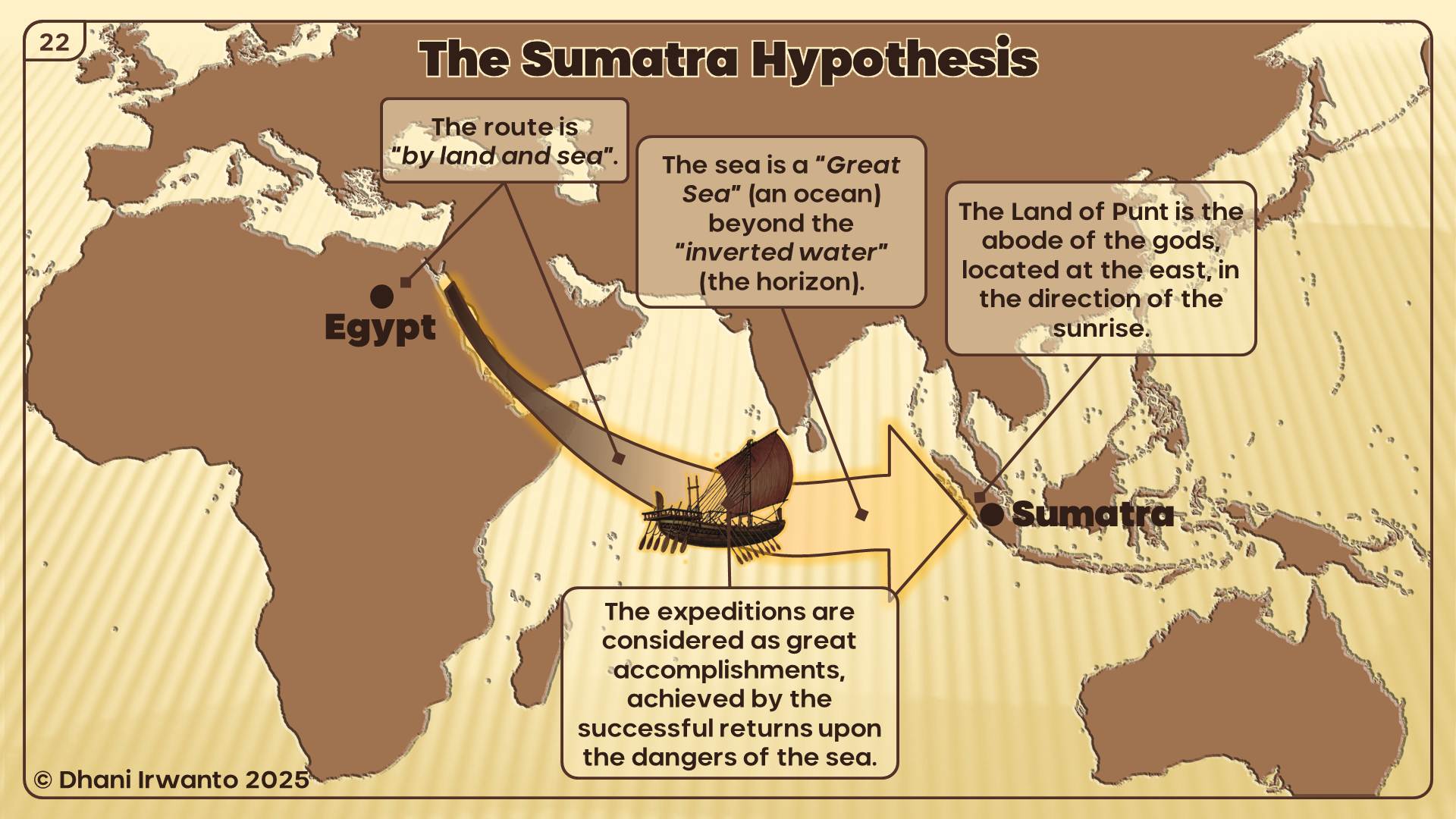
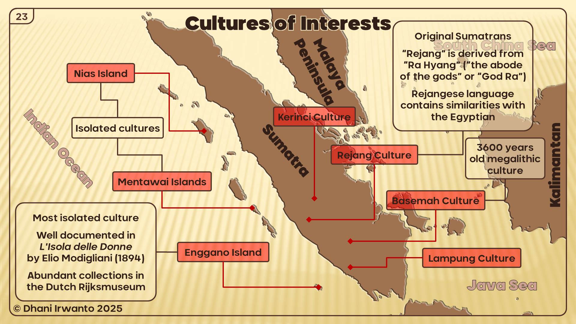
Classical geographers—most prominently Claudius Ptolemy—refer to the Aurea Chersonesus (“Golden Peninsula”), long equated with the Malaya Peninsula. This study re-examines that consensus by triangulating Greco-Roman texts, Indic labels (Suvarṇabhūmi, Suvarṇadvīpa), resource geography, maritime routing, and toponymy. We argue that Ptolemy’s χερσόνησος functions as a scale-normalized, bi-littoral construct: a gold- and tin-forward corridor spanning both shores of the Strait of Malacca. Read geometrically, PtolemyBook 1, ch. 14 treats the first leg parallel to the equator and the second toward south-and-east, consistent with seasonally asymmetric monsoon routing. New contributions include: (i) a Sumatra-centered toponymic thread around Tanjung Emas (“Golden tanjung” —a projecting landform that may be marine or fluvial), accessible from the Bay of Berhala via the Batang Hari corridor and interpreted via metonymy (tanjung → regional chersonesos); and (ii) equator-ambiguous latitude tests combined with an alternative-inclusive crosswalk of Ptolemaic names. Results show that several Sumatra–Batang Hari alignments outperform canonical Malaya Peninsula placements on the latitude metric, and this advantage persists when multiple Malaya Peninsula alternatives are allowed. The framework preserves viable Malay identifications while motivating a Sumatra-focused component of the “Golden” label. It yields falsifiable predictions for archaeometallurgy (interior-to-estuary transects), toponymy audits (paired placements with winners), and sailing-time modeling (monsoon-aware residuals), providing a concrete agenda to confirm or revise the bi-littoral “Golden Corridor” model.
Keywords
Aurea Chersonesus; Golden Chersonese; Suvarnadvīpa; Sumatra; Malaya Peninsula; Ptolemy; Indian Ocean trade; Srivijaya; historical cartography; gold metallurgy; Batang Hari River; Tanjung Emas.
1. Introduction
In classical geography, the Aurea Chersonesus (“Golden Peninsula”) occupies a prominent position at the eastern edge of the Indian Ocean world. The most influential canonical description is found in Ptolemy’s Geography (2nd century CE), whose toponymic lists and coordinate grid—despite known distortions—shaped the medieval and early modern image of the Far East. For over a century of modern scholarship, the Golden Chersonese has been equated with the Malaya Peninsula, a view championed by Gerini, Wheatley, Linehan and others. This mapping is intuitive: Ptolemy’s Greek label chersonēsos refers to a peninsula, and the Malaya Peninsula is the most conspicuous salient in the region.
Yet parallel South and Southeast Asian traditions preserve complementary designations: Suvarṇabhūmi (“Land of Gold”) and Suvarṇadvīpa (“Island of Gold”). The latter is repeatedly linked to Sumatra (Indonesia)—a literal island long noted for its alluvial gold in the Minangkabau interior. Chinese and Arabic itineraries later anchor Srivijaya-era commerce along the Malacca–Andaman corridor, while archaeometallurgical and historical mining records underscore dense gold and tin provinces distributed across the Sunda Shelf. Together these strands suggest that ancient informants may have perceived a trans-Strait gold zone rather than a single, peninsular monocenter.
Classical writers already associated the Far East with Chryse/Aurea (“golden”) long before Ptolemy. The Periplus of the Erythraean Sea places an island called Chryse at the extreme eastern limit “under the rising sun,” a node for fine tortoise-shell and gold-related trade items. Pliny mentions both a promontory Chryse (Promunturium Chryse) and the islands Chryse and Argyre beyond the Indus, keeping “golden” toponymy in play as either cape or island. Pomponius Mela likewise lists Chryse and Argyre as islands, the former with “golden soil,” in his Far Eastern notices. Later poetic geographies such as Dionysius Periegetes (Periegesis) and Avienus (Ora Maritima) preserve the motif of a golden island at the sunrise margin. In South and Southeast Asian sources, Suvarṇabhūmi and Suvarṇadvīpa recur as Indic labels for a “golden land/island”; the Mahāvaṃsa records missions “to Suvarṇabhūmi,” while the Padang Roco (1286 CE) inscription explicitly names Swarnnabhūmi/ Suvarṇabhūmi in a Jambi–Dharmāśraya context, and the Nagarakretagama (1365) situates this golden geography within wider Javanese–Sumatran political space. For consolidated discussion, see the author’s earlier summary.
This paper reframes Aurea Chersonesus through a consilience framework that explicitly integrates: (i) textual–cartographic analysis of Ptolemy’s descriptive geometry and errors, (ii) resource geography (gold and tin provinces), (iii) monsoon-season maritime network modeling, and (iv) toponymy and ethnolinguistics, including a Sumatra-specific thread around Tanjung Emas (“Golden tanjung”) and the Batang Hari River system on Sumatra’s east-flowing watershed. We also incorporate authorial contributions from Sundaland research—specifically Irwanto’s works and website articles—as primary references and as a structured hypothesis to be tested alongside mainstream interpretations. We contend that a bi-littoral Golden Corridor model better explains the overlap between the Greco-Roman “peninsula” label and the Indic memory of an “island of gold,” while remaining open to strict falsification.
This study extends work within the Sundaland research program (2010–present).
Background and prior scholarship.
The standard view equating Aurea Chersonesus with the Malaya Peninsula rests on three pillars: (1) the literal meaning of chersonēsos as “peninsula,” (2) sequences of toponyms in Ptolemy and later writers that seem to fit the Malaya Peninsula littoral, and (3) a century of careful philological and cartographic work that codified these identifications. Against this, critics have flagged well-known features of Ptolemy’s geography: systematic longitude compression, variable latitude accuracy, and the compilation of sailing intelligence from merchants whose reports were stitched into schematic coastlines. The possibility of feature conflation is amplified at the eastern Indian Ocean rim, where two substantial coastlines—the Malaya Peninsula and Sumatra—straddle a narrow strait threaded by seasonal monsoon routes.
In parallel, Indian and Southeast Asian textual memories invoke Suvarṇabhūmi (Land of Gold) and Suvarṇadvīpa (Island of Gold), with the latter specifically resonant with Sumatra. Historians of metallurgy and early Southeast Asian trade have documented significant gold exploitation in Sumatra’s highlands and extensive tin belts on both shores. A consolidated review of Sumatra’s long history of gold production—artisanal, colonial, and modern—appears in van Leeuwen (2014), with a journal update in van Leeuwen (2022). The net result is an evidentiary landscape that supports either a Malaya Peninsula-only model or a broader, paired-shore model—leaving room for careful re-evaluation.
2. Materials and Methods
2.1 Sources and consilience design
Textual–cartographic analysis: reading Ptolemy’s coastal descriptors (promontories, gulfs, river mouths, sailing distances) against modern coastlines, while explicitly modeling the distortions of his coordinate grid.
Resource geography: mapping classical references to “gold” and “tin” onto known ore provinces (Sumatra interior, Malaya Peninsula belts, western Borneo) and comparing them with riverine access to export points.
Maritime network modeling: reconstructing monsoon-dependent sailing legs and currents across the Andaman–Malacca corridor to assess whether a Malaya Peninsula-only or a Malaya Peninsula–Sumatra model better explains reported distances and stopovers.
Toponymy and ethnolinguistics: re-auditing canonical identifications on the Malaya Peninsula side and testing Sumatra-side candidates, with special attention to hydronyms and ancient waypoints along the Batang Hari system; including a linguistic parallel between “Aurea Chersonesus” and “Tanjung Emas” (Golden tanjung).
2.2 Ptolemy’s coordinate system and latitude handling
Ptolemy lists a sequence of coastal features—capes, gulfs, islands—accompanied by latitudes and longitudes aligned to an Alexandrian prime meridian. The transmission of these coordinates is uneven: longitudes are systematically compressed; latitudes are more stable but still subject to copyist error and observational imprecision. For the Golden Chersonese, the relevant coordinates cluster near the equator—within a handful of degrees on either side—consistent with either the Malaya Peninsula’s southern sector or Sumatra’s east-coast theater. This equatorial clustering is not dispositive on its own, but it reduces the discriminating power of latitude while preserving an important constraint for any re-identification.
A key methodological move, therefore, is to treat Ptolemy’s coordinates as weak constraints to be combined with descriptive geometry (e.g., the order of features along a voyage) and sailing times. When this is done, several ambiguities arise that are better resolved by admitting Sumatra’s ports and promontories into the candidate set, rather than forcing a Malaya Peninsula-only mapping.
3. Results
3.1 Quantitative fit to Ptolemy’s latitudes
Latitude comparison with Ptolemy. Using our Sumatra (Batang Hari) coordinates and mainstream Malaya Peninsula placements, we computed residuals per toponym: |Δφ| (absolute signed difference). In the comparison (Table 3), the overall means favor the Sumatra placements as the modal ‘winner’.
3.2 Resource geography: gold, tin, and river access
An independent constraint from ores and rivers. The Sumatran interior (Minangkabau–Barisan) preserves a long record of alluvial and hard-rock gold, with major drainages trending east to the Batang Hari and the Bay of Berhala; historical syntheses outline a province-scale gold belt extending through the central highlands (van Leeuwen 2014; 2022). By contrast, the Malaya Peninsula is classically associated with prolific tin belts (with gold occurrences present but secondary). For distant compilers, such a bi-littoral metalscape could easily coalesce into a generalized “golden” reputation, irrespective of the precise ore mix on each shore.
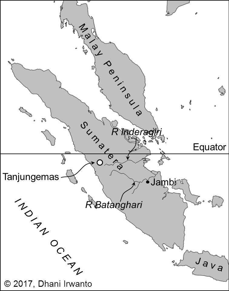
A natural conveyor on the Sumatra side. The Batang Hari functions as a low-gradient corridor from interior sources to estuarine export nodes. In this configuration, Muara Sabak anchors access from the Bay of Berhala, while levee ridges, relict channels, and terrace margins along the lower–middle river offer plausible staging points for beneficiation and transshipment. Even allowing for seasonal constraints, interior-to-coast movement is mechanically feasible in antiquity and consistent with the corridor model proposed here (see Figure 2 for metallogenic context; Table 1 for gazetteer entries).
Implication for the “Golden” label. Read together, (i) a gold-forward Sumatran interior efficiently coupled to an east-draining river system, and (ii) a tin-forward Malay littoral participating in the same exchange circuits, provide a resource-hydrology mechanism by which a bi-littoral corridor could be perceived and named as Aurea. This pattern does not negate canonical Malaya Peninsula placements; it adds a Sumatra-side contribution that is independently motivated by ore belts and river access, and is testable against the toponymic cross-walk (Table 2) and latitude residuals (Table 3).
For historical overviews of Sumatra’s mining districts, see van Leeuwen 2014; 2022.
3.3 Toponymy and linguistic signals
Indic labels and scale. Sources preserve two overlapping labels—Suvarṇabhūmi (“land of gold”) and Suvarṇadvīpa (“island of gold”). While dvīpa literally means “island,” it is scale-flexible in Indic usage (cf. Jambudvīpa for the Indian subcontinent). In our context, the island reading maps neatly onto Sumatra, without excluding broader macro-regional senses that Greco-Roman compilers might have normalized into a single peninsular label.
Malayic tanjung and Greek chersonēsos. In Old Malay/Malayic usage, tanjung denotes a projecting landform in marine, lacustrine, or fluvial settings. The Tanjung Emas district (“Golden tanjung”) is best understood as a promontory-like high ground along the lower surrounding floodplain rather than a marine cape. This semantics resonates with Ptolemy’s chersonēsos—a macro-regional label—and allows a metonymic elevation whereby a renowned local tanjung contributes the name for a wider “golden” littoral. Geographically, the Tanjung Emas hinterland links directly to the Batang Hari corridor, enabling access from the Bay of Berhala inland to the Minangkabau gold belt.
Re-auditing Ptolemy’s names. Ptolemy’s lists of capes, gulfs, and river mouths include several non-consensus identifications. Our approach is a structured toponymy audit across both shores: we prioritize hydronyms, tanjung-promontories, emporia/market towns, and gold-semantic lexemes; we score each candidate on phonology/orthography, morphology/semantics, latitude residuals, and route coherence with neighboring entries. Ties within narrow thresholds (e.g., ≤0.2° latitude; ≤1 day sailing) are recorded as paired candidates, and a “winner” is declared only when one side clears both thresholds. Results are summarized in Table 2 (crosswalk) and Table 3 (latitude/residual tests), with notes on metonymy and potential conflations (a famed cape/emporion naming a wider reach).
Next evidentiary steps. These linguistic placements remain hypotheses to be tested against dated epigraphy, early Malay/Old Javanese/Sanskrit forms, and early Chinese notices around the rise of Śrīvijaya. Convergent support from these lines—together with the resource-hydrology fit and route modeling—would raise the probability of a Sumatra-linked component in the ancient “Golden” label without negating canonical Malaya Peninsula-littoral placements.
3.4 Maritime networks and monsoon timing
Findings from the latitude/residual tests. Across the full set and the near-equator subset, Sumatra–Batang Hari alignments outperform canonical Malaya Peninsula placements. Allowing multiple Malaya Peninsula alternatives per name does not erase this advantage. (See Table 3; cross-references in Table 2.)
Caveats and robustness. Ptolemy’s values carry observational/transcriptional noise, and several Malaya Peninsula identifications remain non-unique. Our residuals are comparative indicators, not absolute fits. Even so, the pattern holds across analysis slices and modeling choices (single-option vs. alternative-inclusive tallies), supporting a Batang Hari-centric reading of several toponyms.
Monsoon-structured routing. The Andaman–Malacca–Java Sea system is seasonally asymmetric. With NE/SE monsoon reversals, westbound and eastbound legs differ in coast selection, sailing times, and stopovers. Interpreted with the Ptolemy Book 1, ch. 14 geometry (first leg parallel to the equator; second south-and-east), the bi-littoral model frequently reduces sailing-time residuals (Figure 4): pilots could hug windward or leeward shores by season, cargo, and political control. On the Sumatra side, the Bay of Berhala → Batang Hari entrance provides a natural gateway; on the Malaya Peninsula side, routes favor tin-rich coastal settlements and established emporia.
Implication. Flexible, seasonally tuned routing is exactly what a “Golden Corridor” predicts: resource collection, transshipment, and long-distance export distributed across both coasts, with the Batang Hari corridor supplying a persistent Sumatran component without displacing viable Malaya Peninsula placements.
3.5 Case study: Batang Hari corridor and the Bay of Berhala
Physical setting and logistics. The Batang Hari drains a broad swath of the Minangkabau–Barisan highlands and debouches to the Bay of Berhala. Its east-trending, low-gradient lower course functions as a natural conveyor from interior gold districts to estuarine exchange nodes (see Figure 2 for metallogenic context). Muara Sabak anchors the mouth; levee ridges, relict channels, and terrace margins along the lower–middle river provide plausible staging points for beneficiation and transshipment, at least seasonally.
Toponymy anchor: Tanjung Emas. The district name Tanjung Emas (“Golden tanjung”) preserves a promontory-linked economic memory. In Malayic usage, tanjung denotes a projecting landform (marine or fluvial); here it fits a promontory-like high ground on the lower surrounding floodplain. Read alongside Greek χερσόνησος (chersonēsos, “peninsula”), this supports a metonymic elevation from a local landmark to a regional ‘golden’ littoral.
Ptolemaic cross-walk signals. Within this theater, several promontoria, sinus/gulfs, river mouths, and islets in Ptolemy’s lists admit tentative Sumatra-side correspondences when screened by (i) latitude residuals (Table 3), (ii) onomastic plausibility (Table 2 notes), and (iii) route coherence under the Ptolemy Book 1, ch. 14 geometry (first leg parallel to the equator, second south-and-east; see Figure 4). We do not sanctify any single identification; rather, we show that a Batang Hari-centric mapping is geographically and semantically coherent within Ptolemy’s equatorial constraints.
Near-term tests. Three checks can raise/lower the case:
(ii) Toponymy audit with scored paired placements (phonology/semantics + |Δφ| + route context);
(iii) Sailing-time residuals comparing Malaya Peninsula-only vs Malaya Peninsula–Sumatra models across monsoon windows (Figure 4). Convergent positives would strengthen a Sumatra-linked component in the ancient “Golden” label without displacing viable Malaya Peninsula identifications.
4. Discussion
4.1 Synthesis: the bi-littoral ‘Golden Corridor’ model
We triangulate the Ptolemaic dossier from three strands: (i) Greco-Roman “Chryse/Aurea” notices (promontory and island traditions), (ii) Indic labels Suvarṇadvīpa/Suvarṇabhūmi, and (iii) material proxies for gold production and exchange in Sumatra. Travel and scholastic itineraries (e.g., Samaraiccakaha; Atīśa, Dharmapāla, Vajrabodhi, Dharmakīrti in Suvarṇadvīpa) keep Sumatra in view; some readers also connect Josephus/Ophir to the Aurea Chersonesus stream. Archaeologically and historically (Lebong Donok/Lebong Tandai, Jambi paleo-alluvials, Salido, Kotacina), the record is consistent with a corridor of gold working rather than a single peninsular monocenter.
We synthesize these into a parsimonious bi-littoral model:
(1) Knowledge compression. Greco-Roman compilers normalized merchants’ reports into schematic forms. A bi-coastal gold/tin region framed by a narrow strait could be compressed into a single “Golden Peninsula” (χερσόνησος) even when source reports alternated between island and peninsula descriptions.
(2) Equatorial constraint. Ptolemy’s latitudes for the Golden Chersonese cluster near the equator. Both a southern Malay salient and an east-Sumatra promontory system satisfy this, so latitude alone does not decide; we therefore compare residuals (Table 3).
(3) Resource–hydrology fit. Sumatra’s gold-bearing highlands drain efficiently to the Batang Hari export gateway; the Malay Peninsula side contributes tin (and gold) via its own river access. The Malacca corridor integrates both shores into long-distance circuits.
(4) Consilience with metallogeny. Independent mining histories outline a Sumatran gold belt compatible with the corridor hypothesis and the Batang Hari axis (e.g., van Leeuwen 2014; 2022). This raises the prior that Ptolemaic “golden” toponyms can include Sumatra-side nodes.
(5) Linguistic echo and metonymy. The Malayic tanjung denotes a projecting landform (marine or fluvial). A famed local tanjung (e.g., Tanjung Emas) can be metonymically elevated to a regional chersonesos in Greek. In parallel, dvīpa in Suvarṇadvīpa is scale-flexible (from island to macro-region). Thus Greek “peninsula” and Indic “island of gold” reflect different scales/vantage points across the same Sumatran-centered corridor (see Table 2 notes).
(6) Itinerary realism. Read geometrically, Ptolemy Book 1, ch. 14 treats the first leg parallel to the equator and the second toward south-and-east (see Greek note). Monsoon-aware sailing reconstructions (Figure 4) naturally touch both shores across seasons; we therefore test Malaya Peninsula-only vs Malaya Peninsula–Sumatra routes by sailing-time residuals.
Implication. The Malay Peninsula mainstream placements remain compatible with a bi-littoral reading; selected toponyms show equal or better Sumatra fits in Table 2 and Tables 3. The corridor model yields testable predictions (archaeometallurgy, toponymy audits, route modeling) rather than a fixed point-location claim.
4.2 Counter-arguments and replies
Etymology (Peninsula vs. Island): Objection: the Greek χερσόνησος (chersonēsos) explicitly means “peninsula,” so an island identification is excluded. Reply: in Ptolemaic usage chersonēsos functions as a typological, macro-regional label—a compiler’s normalization of a coastal zone anchored by salient headlands—rather than a precise geomorphic diagnosis of every node within it. The elasticity is visible in the Greco-Roman dossier itself: “golden” toponyms appear as both promontory and island (e.g., Periplus Maris Erythraei chs. 63–64; Pliny, Natural History 6 [Promunturium Chryse and the Insulas Chrysen et Argyrēn]; Pomponius Mela, Chorographia 3.70; Dionysius Periegetes, Periegesis; Avienus, Ora Maritima). A locally famous tanjung (promontory-like high ground) can thus be metonymically elevated to a regional chersonēsos in Greek. On the Indic side, Suvarṇadvīpa (“island of gold”) is likewise scale-flexible: dvīpa ranges from literal islands to large cultural-geographic units (cf. Jambudvīpa for the Indian subcontinent), and labels such as Suvarṇabhūmi/Suvarṇadvīpa recur in texts and epigraphy (e.g., Mahāvaṃsa; Jātaka; Milinda Pañha; Padang Roco inscription; Nagarakretagama). Read together, the Greek “peninsula” and the Indic “island of gold” reflect different vantage points and scales across the same Sumatran-centered gold corridor, not a contradiction.
Canonical Malaya Peninsula Placements (Mainstream View). Objection: many Ptolemaic names have long-standing Malaya Peninsula identifications—e.g., Tacola → Takua Pa/Takuapa (Phang-nga); Perimulicus → Gulf of Thailand; Sabana → Singapore/Klang; Maleucolon → Malay Point—in classic treatments (Wheatley, The Golden Khersonese; Gerini, Researches on Ptolemy’s Geography of Eastern Asia; McCrindle’s Ptolemy; Stevenson’s trans.). Reply: our model does not displace these; it contextualizes them. We treat Ptolemy’s coastline list as a mixed-granularity gazetteer compiled from pilots’ reports, in which some labels are typological or metonymic. Accordingly, (i) we admit the Malaya Peninsula littoral assignments where they fit; (ii) we test paired candidates where direction/latitude residuals and onomastic/morphological cues are sharper on Sumatra (e.g., tanjung-based promontories, Batang Hari corridor nodes); and (iii) we allow for conflations (a famed cape/emporion naming a wider reach) and equatorial sign flips in transmission. In short, the Malaya Peninsula mainstream placements remain compatible with a bi-littoral model, while selected toponyms may find better or dual fits on Sumatra; the tables (2, 3) make these tests explicit.
Absence of excavated gold-processing sites on the proposed Sumatra promontory. Critics may note the thin archaeometallurgical record along the east-Sumatra estuaries. Reply: in tropical deltaic settings, surface features of gold working (sluice lines, small pits, earthen settling basins) are low-visibility and often erased by avulsion, mangrove accretion, and agriculture; the highest archaeological signal is expected up-basin on stable terraces rather than on the active estuary front. Independent geological/historical syntheses nevertheless document a long-lived Sumatran gold province, e.g., colonial records of at least 14 gold mines (1899–1940) with ~101 t Au produced—dominated by the Lebong Donok/Lebong Tandai district—situated within broader epithermal/orogenic belts that extend into the Batang Hari hinterland. These histories do not “prove” estuarine processing sites, but they raise prior probability that such sites existed and are masked by taphonomy and survey bias.
4.3 Limitations
Four limitations are salient.
(1) Textual–cartographic uncertainty. Ptolemy’s coordinates are copy-derived (via Marinus) with known distortions (prime-meridian choice, scale/shape compression) and scribal sign errors near the equator. Our use of residual table (Table 3) reduces but does not eliminate this noise; we therefore emphasize relative fits (comparative residuals, paired candidates) over absolute placements.
(2) Geomorphic and taphonomic loss. Tropical delta dynamics—rapid sedimentation, avulsion, mangrove accretion, later agriculture and extraction—erase or bury low-visibility gold-working signatures. This biases the surface record toward up-basin stability. We address this by prioritizing subsurface sampling (coring, geophysics), targeting terrace/levee contexts, and running negative-control transects outside the corridor to bound false positives.
(3) Linguistic palimpsest and onomastic drift. The Malay world layers Sanskritic, Malayic, Old Javanese, and local substrates; later Islamic/colonial spellings and folk etymologies confound straight etymologies. Our crosswalk treats names as probabilistic matches—scored on phonology, semantics, geography, and route coherence—and explicitly records dual candidates where ties persist. Definitive resolutions will require collaboration with historical linguists and dated toponym attestations.
(4) Model simplifications in route simulations. Sailing-time reconstructions approximate seasonal winds, currents, hull/sail performance, and unknown stopovers; the Greek narrative (Ptolemy Book 1, ch.) is interpreted geometrically (first leg parallel to the equator; second leg south-and-east), but alternative readings exist in translations. We mitigate by reporting per-leg residuals, running parameter sweeps/sensitivity analyses, and using results to compare Malaya Peninsula-only vs. Malaya Peninsula–Sumatra models rather than to assert exact day-to-mile conversions.
(A further limitation is evidence imbalance: Malaya Peninsula littoral archaeology is generally better published than Sumatra’s. We note this asymmetry and frame our claims as testable predictions to motivate targeted fieldwork.)
Objective. Test for placer-gold processing signatures along the Batang Hari corridor from upper–middle confluences (e.g., Tembesi, Sijunjung) to lower-delta levees/relict channels (Muara Sabak; adjacent tanjung promontories ~0–5 m above active floodplain).
Design & methods.
Remote sensing/terrain: SRTM/photogrammetry/LiDAR (if available) to map linear tailings/berms, abandoned race lines, terrace-edge benches.
Coring/transects: vibracoring or Russian-auger lines across levees, point bars, abandoned channels (interior→estuary gradient), plus negative-control transects outside the hypothesized corridor.
Artefact/microresidue survey: hammer-stones, anvils, crushing slabs; micro-quartz abraded flour, soot/ash films; note that smelting slag is uncommon in placer contexts.
Geochemistry: fines screening for Au–Ag; Hg spikes as amalgamation proxy (pXRF/ICP-MS); SEM–EDS/FTIR on concentrates.
Targeted geophysics: magnetometry/EM for hearth lenses or burned features.
Chronology: AMS ^14C (charcoal) and OSL (tailings/levee accretion) to bracket activity phases.
Decision rules (falsifiable).
Support for the estuary-linked processing prediction if ≥2 independent lines (e.g., Au–Ag fines + micro-abrasion + dated hearth lens) co-occur at lower Batang Hari nodes and yield dates broadly consistent with 1st–3rd c. CE (Ptolemaic horizon) or sustained pre-/protohistoric activity.
Revision trigger if signatures are absent at estuary nodes but present upstream only (interior-focused beneficiation), or if dating clusters far outside the hypothesized window.
Outputs. Georeferenced site inventory (interior→estuary), GIS layers for candidate features, analytical microresidue catalogue, and a brief QA/QC note on contamination controls; figure panel summarizing positive/negative transects.
(2) Toponymy audit (paired placements, scored).
Build a bilingual/trilingual gazetteer for Ptolemaic ↔ Malay/Old Javanese/Sanskrit forms on both shores (Batang Hari basin vs. Malaya Peninsula littoral).
Prioritize hydronyms, promontory names (tanjung), emporia/market towns, and gold-semantic lexemes.
For each Ptolemaic name, compute a composite score: (i) phonology/orthography match; (ii) morphology/semantics (e.g., “gold,” “cape,” “river”); (iii) |Δφ| (latitude residual, with equator-ambiguity rule near 0°); (iv) route coherence with adjacent names.
Treat ties ≤0.2° latitude and ≤1 day sailing as dual candidates; record a “winner” only when one candidate clears both thresholds.
Outputs: updated Table 2 (notes/etymology column expanded) and Table 3 (scores + winners), plus a short appendix on sound correspondences/loan patterns.
(3) Sailing-time modeling (seasonal residuals).
Run eastbound/westbound simulations under NE/SE monsoon windows using simple square-sail polars and coastal tacking constraints.
Compare two route families: Malaya Peninsula-only vs Malaya Peninsula–Sumatra (with Muara Sabak / Batang Hari stopover).
Convert reported “days” to distance via Ptolemaic reduction rules (Leg-1 parallel to equator; Leg-2 S+E bearing).
Report per-leg residuals (simulated vs. Ptolemaic) and a total misfit (median absolute % error).
Decision rule: Sumatra model is preferred if it reduces total misfit by ≥20% and improves at least two contiguous legs.
Outputs: revised Figure 4 panels with residual boxes, plus a one-page methods note.
Overlay gold-province belts (epithermal/orogenic districts) with river least-cost paths to export nodes; estimate interior-to-estuary tonnage friction.
Inputs: ore-belt polygons, SRTM-derived river networks/gradients, navigability classes, portage penalties, and historical mine districts.
Compute for each basin (e.g., Batang Hari vs. Pahang/Perak) a logistics index: (ore endowment × fluvial efficiency) → predicted export throughput.
Decision rule: Hypothesis gains support if Batang Hari ranks top-two under ≥2 parameterizations and aligns with high-score toponyms.
Outputs: a small metallogenic overlay figure (supporting Figure 2) and a table of basin indices to cite in Discussion.
6. Conclusion
Treating Aurea Chersonesus as a scale-normalized, bi-littoral construct reconciles Ptolemy’s χερσόνησος (“peninsula”) with Indic Suvarṇadvīpa (“island of gold”). Our reading of Ptolemy Book 1, ch. 14—first leg parallel to the equator, second leg toward south-and-east—and the Malayic semantics of tanjung (a projecting landform, not necessarily marine) allow a metonymic elevation from a local promontory (e.g., Tanjung Emas) to a regional chersonesos. Quantitatively, the latitude tests and the toponymy crosswalk (Tables 3, 2) show that several names admit equal or better fits on the Sumatra side, especially along the Batang Hari corridor, while leaving canonical Malaya Peninsula littoral placements intact where they remain competitive. Independent metallogenic histories of Sumatra’s gold province further raise the prior for a Sumatra-centered corridor rather than a single peninsular point.
The model is deliberately testable. Three levers can raise or lower its probability: (i) archaeometallurgical survey targeted at terrace/levee nodes from interior to estuary; (ii) toponymy audits that resolve paired/dual placements; and (iii) sailing-time residuals under seasonal winds (Figure 4). At a minimum, the Golden Chersonese should be read as a corridor, not a dot on the map—one in which Sumatra’s Suvarṇadvīpa plays a constitutive role while Malay Peninsula identifications remain part of a bi-littoral solution set.
Acknowledgments
I thank colleagues and readers for helpful comments on earlier drafts. This article draws on datasets developed in the Sundaland research program (2010–present); all interpretations and any errors are my own.
Funding
No external funding was received. The research was undertaken within the Sundaland research program.
Data availability
All tabular data are provided in Table 1, Table 2, and Table 3. Working spreadsheets and figure files are available from the author on reasonable request.
Competing interests
The author declares no competing interests.
Ethical approval
Not applicable.
References
Avienus, Rufus Festus. 1934. Ora Maritima. Ed. A. Berthelot. Paris: Les Belles Lettres.
Dionysius Periegetes. 2014. Dionysius Periegetes: Description of the Known World. Ed., trans., and comm. J. L. Lightfoot. Oxford: Oxford University Press.
Gerini, G. E. 1909. Researches on Ptolemy’s Geography of Eastern Asia (Further India and Indo-Malay Archipelago). London: Royal Asiatic Society & Royal Geographical Society.
Irwanto, Dhani. 2019 Sundaland: Tracing the Cradle of Civilizations. Bogor: Indonesia Hydro Media. ISBN: 9786027244924. (includes section on Aurea Chersonesus)
Josephus, Flavius. 1930–1965. Jewish Antiquities. Trans. H. St. J. Thackeray et al. Loeb Classical Library. Cambridge, MA: Harvard University Press. (See esp. Vol. I, 1930.)
Jātaka: Stories of the Buddha’s Former Births. 1895–1907. 6 vols. Trans. R. Chalmers, W. H. D. Rouse, H. T. Francis, and E. B. Cowell (ed.). Cambridge: Cambridge University Press (for the Pali Text Society; reprinted PTS, 1990).
Linehan, W. 1951. “The Identifications of Some of Ptolemy’s Place-Names in the Golden Khersonese.” Journal of the Malaya Peninsulan Branch of the Royal Asiatic Society 24 (3): 1–24.
Mahāvaṃsa. 1912. The Mahāvaṃsa or The Great Chronicle of Ceylon. Trans. Wilhelm Geiger. London: Published for the Pali Text Society by Oxford University Press.
Milinda Pañha (The Questions of King Milinda). 1890–1894. 2 vols. Trans. T. W. Rhys Davids. Sacred Books of the East 35–36. Oxford: Clarendon Press.
Padang Roco (Amoghapāśa) Inscription. 1286 CE. For text, discussion, and translations see: Krom 1916; Moens 1924; Slamet Muljana 1981; and later syntheses.
Periplus of the Erythraean Sea. 1989. The Periplus Maris Erythraei: Text with Introduction, Translation, and Commentary. Trans. Lionel Casson. Princeton, NJ: Princeton University Press.
Pliny the Elder. 1942. Natural History, Vol. II: Books 3–7. Trans. H. Rackham. Loeb Classical Library 352. Cambridge, MA: Harvard University Press.
Ptolemaeus, Claudius. 1843–1845. Claudii Ptolemaei Geographia. Ed. C. F. A. Nobbe. Leipzig: B. G. Teubner (repr. Hildesheim: Georg Olms, 1966).
Ptolemaeus, Claudius. 1932. The Geography of Claudius Ptolemy. Trans. and ed. Edward Luther Stevenson; intro. Joseph Fischer. New York: New York Public Library (repr. Dover, 1991).
Ptolemaios, Klaudios. 2006. Handbuch der Geographie. Griechisch–Deutsch. Eds. Alfred Stückelberger and Gerd Graßhoff. 2 vols. Basel: Schwabe.
van der Meulen, W. J. 1974. “Suvarṇadvīpa and the Chrysê Chersonêsos.” Indonesia 18 (October): 1–40.
van Leeuwen, T. M. 2014. “A Brief History of Mineral Exploration and Mining in Sumatra.” In Proceedings of Sundaland Resources 2014 – MGEI Annual Convention (Palembang, 17–18 Nov). https://doi.org/10.13140/2.1.2278.5607.
Wheatley, Paul. 1961. The Golden Khersonese: Studies in the Historical Geography of the Malaya Peninsula before A.D. 1500. Kuala Lumpur: University of Malaya Peninsula Press. Repr. 1973, Westport, CT: Greenwood Press.
Figure 1. Regional map of the Malaya Peninsula–Sumatra bi-littoral “Golden Corridor”.
Figure 2. Distribution of mineral occurrences, prospects and deposits in Sumatra (van Leeuwen and Pieters, 2014). Location of Tanjung Emas is added.
Figure 3A. Reconstruction of Ptolemy’s coordinates and identified toponymy for area of Golden Chersonese (Irwanto, 2017).
Inset is the plot of places given by Ptolemy with his coordinate system. Numbers are related to the explanations in the text.
Figure 3B. Reconstruction of Ptolemy’s coordinates and identified toponymy for area of eastern coast (Irwanto, 2017).
Inset is the plot of places given by Ptolemy with his coordinate system. Numbers are related to the explanations in the text.
Figure 3C. Reconstruction of Ptolemy’s coordinates and identified toponymy for area of piracy prone (Irwanto, 2017).
Inset is the plot of places given by Ptolemy with his coordinate system. Numbers are related to the explanations in the text.
Figure 4A. Monsoon routing schematic with sailing-time residuals (Malay Peninsula-only vs Malay Peninsula–Sumatra models)— residuals from observed rutters (Δt, days).
Figure 4B. Monsoon routing schematic with sailing-time residuals (Malay Peninsula-only vs Malay Peninsula–Sumatra models)— A/B/C segmentation (modeled at 4 kn; Δt for C only).
Table 1. Gazetteer and GIS coordinates (Batanghari corridor).
Ptolemaic Form
Feature Type
Modern Name
Longitude
Latitude
Aurea Chersonesus
promontory
Tanjung Emas (“Golden Promontory”)
100.762972
-0.438524
Balonca
place
Batu Sangkar
100.593900
-0.456900
Tacola
emporium (trading place)
Tikalak, Singkarak
100.597700
-0.676600
Cocconagara
place
Nagari Solok
100.653100
-0.791100
Palanda
fluvius (river)
Batang Lunto
100.800529
-0.706759
Palanda
place
Sawah Lunto
100.778400
-0.682000
Chrysoana/Chrysoanu
fluvius (river)
Sungai Mas (‘gold river’), Selo River and upper Ombilin River
100.634200
-0.492800
Tharra
place
Muara (Muara Sijunjung)
100.944600
-0.664700
Attibam
fluvius (river)
Upper Batang Hari River
101.597545
-0.963209
Promontorium
promontory
Several places named with “Tanjung” (“promontory”) at coast of Lake Singkarak
100.566780
-0.598574
Perimula
place
Berhala Island
104.040085
-0.516267
Perimulicus
sinus (bay)
Bay/Strait of Berhala
103.933170
-0.667159
Coli
civitas (social body of citizens)
Several places named with “Kuala” (“estuary” [of small rivers]) at eastern coast
103.594618
-0.932387
Coli
civitas (social body of citizens)
Kuala Tungkal
103.406822
-0.825672
Attaba
fluvius (river)
Batang Hari River (previously Batang Sabak River)
103.720431
-1.434334
Maleucolon
promontory
Sungai Lokan (village), Tanjung Jabung (promontory)
104.357700
-1.059200
Sabana
emporium (trading place)
Jambi city
103.611100
-1.607200
Zabæ
civitas (social body of citizens)
Muara Sabak (a village at estuary (‘muara’) of Sabak/Batang Hari River)
104.037921
-1.101304
Sarabes
estuary
Muara (estuary of) Sabak (river)
103.848494
-1.122666
Acadra
place
Koto Kandis
104.055669
-1.239440
Thipinobasti
emporium (trading place)
Suak Kandis
103.982107
-1.394223
Sobani
fluvius (river)
Lesser Jambi Stream, Muaro Jambi
103.626978
-1.481124
Pagrasa
place
Lubuk Rusa
103.359029
-1.561840
Samarade
place
Muara Tembesi
103.121965
-1.723715
Deltaic channel/ Settlement
Nipah Panjang
104.207044
-1.071452
Delta channel/River
Mendahara River
103.915658
-1.143107
Table 2. Toponymy crosswalk (Malaya Peninsula mainstream vs. Sumatra candidates).
Muara Sabak (a village at estuary (‘muara’) of Sabak/Batang Hari River)
Sarabes
estuary
Uncertain placement
Muara (estuary of) Sabak (river)
Acadra
place
Hà Tiên (Gulf of Thailand)
Koto Kandis
Thipinobasti
emporium (trading place)
Hà Tiên sector
Suak Kandis
Sobani
fluvius (river)
Uncertain/not attested
Lesser Jambi Stream, Muaro Jambi
Pagrasa
place
Uncertain/not attested
Lubuk Rusa
Samarade
place
Uncertain/not attested
Muara Tembesi
Deltaic channel/ Settlement
nan
Uncertain/not attested
Nipah Panjang
Delta channel/River
nan
Uncertain/not attested
Mendahara River
Note on McCrindle’s “coast facing south” (Ptolemy, Geog. 1.14)
A widely quoted English rendering by McCrindle reads: “since as the coast faces the south it must run parallel with the equator … ‘we must reduce … from Zabæ to Kattigara, since the course of the navigation is towards the south and the east.’”
The underlying Greek makes a geometric point about coastline orientation, not a southbound course on the first leg. Ptolemy says the Golden Chersonese → Zabæ stretch is “παράλληλον οὖσαν τῷ ἰσημερινῷ” (“parallel to the equator”), and explains that the intervening region runs opposite to the south—i.e., it trends east–west—so no angular reduction is needed. By contrast, the Zabæ → Cattigara leg is explicitly a sailing bearing: “τὸ τὸν πλοῦν εἶναι πρὸς νότον καὶ πρὸς ἀνατολάς” (“the voyage is toward the south and toward the east”), which is why that leg is reduced.
Implication. Translating the first clause as “the coast faces south” risks a syntagmatic slippage: it treats a statement about coastal aspect (used to justify an E–W treatment) as if it were the ship’s heading. Read with the Greek geometry in view, Ptolemy’s two-step logic is: (1) GC → Zabæ runs parallel to the equator (no reduction), then (2) Zabæ → Cattigara runs SE (reduce to the E–W component).
[1] Local usage of tanjung denotes a projecting landform in marine, lacustrine, or fluvial settings; here Tanjung Emas is a higher patch protruding into a lower floodplain along the Batanghari, not necessarily a marine tanjung. Metonymy: a prominent tanjung can label its surrounding littoral; Ptolemy’s chersonesos may reflect such upscaling.
[2] Greek text (PtolemyBook I): Τὴν μὲν οὖν ἀπὸ τῆς Χρυσῆς Χερσονήσου ἐπὶ Ζάβας οὐδέν τι δεῖ μειοῦν, παράλληλον οὖσαν τῷ ἰσημερινῷ, διὰ τὸ τὴν μεταξὺ χώραν ἀντίαν ἐκτετάσθαι τῇ μεσημβρίᾳ. [Lit.] “There is no need to reduce the [distance] from the Golden Chersonese to Zabæ, (it) being parallel to the equator, because the region between extends opposite to the south (i.e., trending east–west).” τὴν δ᾽ ἀπὸ Ζαβῶν ἐπὶ τὰ Καττίγαρα προσήκει συνελεῖν διὰ τὸ τὸν πλοῦν εἶναι πρὸς νότον καὶ πρὸς ἀνατολάς. [Lit.] “But the (distance) from Zabæ to Cattigara must be shortened, because the voyage is towards the south and towards the east.”
Table 3. Ptolemy vs Sumatra and Malaya Peninsula placements (|Δφ|)
Ptolemaic form
Ptolemy lat (reported) (deg)
Sumatra candidate (modern)
Sumatra lat (deg)
Sumatra |Δφ| (deg)
Malaya lat (deg)
Malaya |Δφ| (deg)
Acadra
-4.833
Koto Kandis
-1.239
3.594
10.380
15.213
Attaba
-1.000
Batang Hari River
-1.434
0.434
3.530
4.530
Attibam
-3.000
Upper Batang Hari River
-0.963
2.037
3.800
6.800
Balonca
4.667
Batu Sangkar
-0.457
5.124
Chrysoana/ Chrysoanu
1.000
Sungai Mas, Selo River and upper Ombilin River
-0.493
1.493
4.020
3.020
Chrysoana/ Chrysoanu
-1.333
Sungai Mas, Selo River and upper Ombilin River
-0.493
0.840
4.020
5.353
Cocconagara
2.000
Nagari Solok
-0.791
2.791
Coli
0.000
Several places named with “Kuala” at eastern coast
-0.932
0.932
6.150
6.150
Maleucolon
-2.000
Sungai Lokan Tanjung Jabung
-1.059
0.941
2.500
4.500
Pagrasa
-4.833
Lubuk Rusa
-1.562
3.271
Palanda
-1.500
Batang Lunto
-0.707
0.793
1.730
3.230
Palanda
-2.000
Sawah Lunto
-0.707
1.293
1.420
3.420
Perimula
2.667
Berhala Island
-0.516
3.183
8.430
5.763
Perimulicus
4.250
Bay/Strait of Berhala
-0.667
4.917
10.000
5.750
Promontori-um
2.667
Several places named with “Tanjung” at coast of Lake Singkarak
-0.599
3.265
2.500
0.167
Promontori-um
4.250
Several places named with “Tanjung” at coast of Lake Singkarak
A research by Dhani Irwanto, 26 August 2025, addendum 3 September 2025
Abstract
This essay re-reads Timaeus and Critias through the literal Greek στόμα [stoma, “mouth; opening; entrance”] and argues that “Pillars of Heracles” in the Atlantis passage is a Greek nickname for a functional sea entrance rather than a fixed strait. It reconstructs a pilot’s sequence—outer sea → mouth → inner sea → local canal → ringed salt-water basins—and situates the terminology within Aegean seamanship and Cretan myth. The discussion then applies this framework to the Kangean Mouth and Java Sea interior as a testable case, without relocating the Pillars into Atlantis. The result is a navigational, not monumental, reading that clarifies “beyond/within” and provides concrete criteria for evaluating proposed geographies.
This article also makes explicit the method by which meaning is recovered. We treat στόμα [stoma, “mouth; opening; entrance”] as a sign whose meaning is to be sought in context rather than presumed. The inquiry proceeds by (i) semiotics (Saussure’s signifier/signified; Peirce’s icon/index/symbol; Barthes’ Orders 1–3), (ii) linguistics (syntagmatic chain, paradigmatic choice, commutation tests, pragmatics), and (iii) philology (ancient Greek usage and intertexts). Read this way, the text yields a two-threshold pilotage sequence: outer sea → sea-mouth → inner sea → local canal → ringed basins.
Within this framework, the priest’s phrase Ἡρακλέους στήλαι [Herakleous stelai, “Pillars of Heracles”] functions as a Greek ethnonymic label for the sea-mouth, not as a monument located inside Atlantis. The “beyond/within” pair—πρὸ τοῦ στόματος [pro tou stomatos, “before the mouth”] vs. ἐντὸς τοῦ στόματος [entos tou stomatos, “within the mouth”]—is thus doorway language, not a trick of bearings.
We also make explicit a crucial context clue in the dialogue: the Egyptian priest’s audience-accommodation when naming the gateway. He says, in effect, “the entrance which you Greeks call the Pillars of Heracles” (Greek: ὃ παρ’ ὑμῖν … Ἡρακλέους στήλαι [ho par’ hymin … Herakleous stelai, “what among you is called the Pillars of Heracles”]). This phrasing signals that the navigational gate has no fixed Greek technical term in the source tradition; instead, the priest borrows the Greek sailors’ ethnonymic label so the Athenian audience will recognize the function being discussed. Semiotics and pragmatics therefore support reading the Pillars here as a Greek name for a sea-mouth (στόμα, stoma), not as a monument inside Atlantis.
Finally, we treat the Kangean Mouth/Java Sea as a Barthes Order-3 application (an assembled structured object). The question is empirical: does the Kangean–Java setting instantiate the full pilotage sequence and its landscape cues? The approach invites consilience—independent lines of evidence must converge if the model is to be preferred over rivals.
Most modern readings of Plato’s Atlantis begin at a celebrity landmark. This essay starts with the words themselves. In Timaeus and Critias, the mariner first passes a στόμα θαλάσσης [stoma thalasses, “mouth of the sea; sea mouth”], which the Egyptian priest says the Greeks call the Pillars of Heracles; only then does he work an inner sea, and only then a narrow canal into ringed harbor basins. Treating “Pillars of Heracles” as the Greek nickname for the mouth—not a monument in Atlantis—restores the helmsman’s course and clarifies “beyond” and “within”. Set against Aegean seamanship and Cretan myth, this reading supplies clear criteria that can be applied to real geographies. Here we apply it to the Kangean Mouth and the Java Sea interior, without claiming the label itself ever stood in the Indies: the point is the function, not a fixed latitude.
1. A discursive reading of Plato’s route
Plato narrates a course rather than a map. The sailors begin in the outer sea and sight a recognized entrance, the στόμα θαλάσσης [stoma thalasses, “mouth of the sea; sea mouth”], or sea mouth. In his wording, what lies πρὸ τοῦ στόματος [pro tou stomatos, “before the mouth”] is the true, outer sea, with long fetch and swell; what lies ἐντὸς τοῦ στόματος [entos tou stomatos, “within the mouth”] is a calmer interior: a navigable basin enclosed by continental-scale land. Only once that interior is reached does the focus narrow to an island with engineered works. A second, local threshold appears here: a διώρυξ [dioryx, “canal; cut”] that admits ships into concentric basins. Because θάλασσα [thalassa, “sea; salty water”] can mean salty water as well as the sea at large, Plato can call those basins “seas” without contradiction. The full sequence is: outer sea → sea mouth → inner sea → local canal → ringed basins.
Plato cue:Timaeus 24e–25a evokes the outer vs inner contrast; Critias 115d–116d describes the canal and the ringed basins.
2. Why the word “mouth” matters and what the Pillars are (and are not)
The key noun in Plato is στόμα [stoma, “mouth; opening; entrance”] in the phrase ἐντὸς τοῦ στόματος [entos tou stomatos, “inside the mouth”], set over against ἔξωθεν … ἐκ τοῦ Ἀτλαντικοῦ πελάγους [exothen … ek tou Atlantikou pelagous, “from outside, out of the Atlantic sea”]. Taken literally, Plato frames the approach as passing a sea‑mouth (gateway) from the outer sea into an inner one; translating στόμα as “strait” is an interpretive narrowing, not a requirement of the Greek. The Egyptian priest then clarifies that this gateway is “what you Greeks call the Pillars of Heracles” (Greek: Ἡρακλέους στήλαι [Herakleous stelai, “Pillars of Heracles”]), which reads naturally as a Greek sailors’ label for the entrance under discussion, not a feature inside Atlantis. This keeps two thresholds distinct—(i) the sea‑mouth (“Pillars”) between outer and inner seas and (ii) the later διώρυξ [dioryx, “canal; cut”] into the ring‑harbors—without importing extra geography into the sentence.
Note. For an Athenian audience, “Pillars of Heracles” ordinarily evoked the western world‑gate. Here the term functions first as a label for the στόμα in Plato’s syntax; comparative geographic anchoring is evaluated separately in the application.
3. A functional label in Greek literature, not a fixed monument
Greek authors often use the Pillars of Heracles as a limit-name, a proverbial boundary of sailing rather than a set of stones in a city. In Pindar the Pillars mark the farthest reach of human endeavor; in Isocrates (Philippos 111–112) Heracles sets up trophies that define the boundary of the Hellenes. Geographers like Strabo record competing identifications for the Pillars—temple columns at Gades, islets, or facing capes at an ocean mouth—which shows that even in antiquity the label was not static.
Independently of the heroic label, Greek prose routinely calls chokepoints στόμα [stoma, “mouth; opening; entrance”]. One speaks of the στόμα Πόντου [stoma Pontou, “mouth of Pontus (Black Sea entrance)”] for the Black Sea entrance. In everyday pilotage, multiple mouths mattered to Greek seafaring: the Hellespont into the Propontis and onward to the Black Sea; the Cretan approaches into the Aegean; the Strait of Messina and the Sicily Channel between the Ionian and Tyrrhenian or the eastern and western basins; and, more peripherally, the Atlantic mouth at Gibraltar. The point is functional: a mouth is a gateway between water bodies, often carrying a culturally loaded name.
4. Pre-Solon seamanship and a gradient of knowledge
Classical memory credits early Crete with a thalassocracy and imagines Minoan power as maritime. Whether in empire or in everyday cabotage, Aegean pilots learned by repetition at major mouths—Hellespont, Cretan approaches—collecting rules of season and wind, lee and eddy. That is the core of Greek nautical experience.
Beyond the Aegean, Greek knowledge stretched west through the Ionian and Tyrrhenian and toward the far Atlantic mouth, often by way of Phoenician mediation. Those thresholds were real and named, yet less routine for many Aegean sailors. This gradient explains why a Greek narrator would naturally speak in mouth/inside terms while leaving the exact identity of any far-west gate more fluid in literature.
5. Why a Cretan lens strengthens the sea-mouth reading
In mythic geography Crete is the island of Zeus and a stage for Heracles, whose capture of the Cretan Bull links the hero to the island. In such a world, naming a gate after a hero is both memory and signal: a way to imprint a threshold in a sailor’s mind. The toponym Heraklion shows how the hero’s name endures in Cretan space.
From this lens, the phrase “which you Greeks call the Pillars of Heracles” reads like a mariner’s nickname for a mouth at the relevant stage of a voyage. The sequence Plato gives—mouth, interior basin, second local entrance, rings—matches a helmsman’s logic for approaching a fortified island port on the lip of a plain.
Figure 1. Aegean/Cretan context for a “Pillars of Heracles” gate-name. Dashed arc marks a conceptual sea mouth; the label is a Greek nickname for an entrance, not a fixed monument.
6. “Beyond” and “within”: a semantic discussion rather than a direction-finding trick
The contrast between πρὸ τοῦ στόματος [pro tou stomatos, “before the mouth”] and ἐντὸς τοῦ στόματος [entos tou stomatos, “within the mouth”] is doorway language. The doorway is the στόμα θαλάσσης [stoma thalasses, “sea mouth; mouth of the sea”], the sea mouth. Read this way, “beyond” means ocean-ward of the entrance currently being worked; “within” means basin-ward. Fixing the Pillars at a single western landmark is a later habit that need not control Plato’s phrasing in this passage.
7. From outer sea to ringed harbors: Plato’s wording in sequence
The narration flows without a break when read as pilotage. First comes the outer sea and the recognized mouth: “Outside the entrance lies the true sea; but the sea inside the mouth is enclosed, and the land around it may most truly be called a continent” (Timaeus 24e–25a). Then comes the interior geography of islands leading toward a larger land: “Opposite the mouth there lay an island, from which you could pass to other islands, and from them to the whole of the opposite continent” (Timaeus 25a–b).
Only inside the basin does the narrative narrow to engineered features: διώρυξ [dioryx, “canal; cut”] for a canal from the sea to the outer ring and κύκλοι θαλάσσης καὶ γῆς [kykloi thalasses kai ges, “rings of sea and land”] for rings of sea and land, bridged so ships could pass below (Critias 115d–116d). The large entrance and the local canal are distinct thresholds.
8. A Semiotic Lens on στόμα and the “Pillars of Heracles”
Sign and task. In this reading, στόμα [stoma, “mouth; opening; entrance”] is treated as a sign whose meaning is “to be sought” in context rather than presumed. Its phrase στόμα θαλάσσης [stoma thalasses, “sea mouth; mouth of the sea”] cues a functional gateway within a navigation narrative.
Context clue (pragmatics): audience accommodation in the priest’s phrasing. The Egyptian priest frames the entrance as “what among you is called the Pillars of Heracles” (Greek: ὃ παρ’ ὑμῖν … Ἡρακλέους στήλαι [ho par’ hymin … Herakleous stelai, “what among you is called the Pillars of Heracles”]).
Transliteration and literal sense.Ἡρακλέους στήλαι [Herakleous stelai, “Pillars of Heracles”] is the Greek label; παρ’ ὑμῖν [par’ hymin, “among you (Greeks)”] marks audience-specific naming.
Semiotic force. Pragmatically, the priest code-switches to a Greek exonym for an entrance whose native (Egyptian/Atlantean) term is not shared. As a symbol, the phrase invokes a conventional Greek gateway-name; as an index, it points to a functional sea-mouth; as an icon, “mouth” evokes the form (narrowing/widening) that pilots recognize.
If the meaning were a universally fixed Greek proper name with no ambiguity, the accommodation “what you Greeks call …” would be unnecessary. The wording therefore supports treating Pillars here as a Greek ethnonymic label for the στόμα, not as a feature located inside Atlantis.
Saussure (dyadic). The signifier is the sequence of sounds/letters στόμα; the signified is the seafaring entrance/gateway that separates the outer (ἔξωθεν … ἐκ τοῦ Ἀτλαντικοῦ πελάγους [exothen … ek tou Atlantikou pelagous, “from outside, out of the Atlantic sea”]) from the inner (ἐντὸς τοῦ στόματος [entos tou stomatos, “within the mouth”]). Choosing στόμα rather than a stricter “strait” term preserves the doorway metaphor and the two-threshold logic.
Peirce (triadic).
Icon: the mouth’s form (bottleneck widening to basin).
Index: hydrodynamics (swell attenuation, tidal jets, lee and eddy) that pilots observe at entrances.
Symbol: Ἡρακλέους στήλαι [Herakleous stelai] as a conventional Greek name for a sea gate.
Barthes (orders of signification).
Order 1 (denotation): στόμα, στόμα θαλάσσης—a mouth/entrance.
Order 2 (connotation): Aegean pilotage culture, Cretan mythic lens, and the contrast πρὸ τοῦ στόματος [pro tou stomatos, “before the mouth”] vs. ἐντὸς τοῦ στόματος [entos tou stomatos, “within the mouth”] shape “beyond/within” as doorway language.
Order 3 (assembled object): the pilotage sequence—outer sea → sea-mouth → inner sea → local διώρυξ [dioryx, “canal; cut”] → κύκλοι θαλάσσης καὶ γῆς [kykloi thalasses kai ges, “rings of sea and land”]—yields a structured model to test against real coasts.
Linguistic tests.
Syntagmatic chain: preserves the pilot’s order of operations (outer sea → mouth → inner sea → local canal → rings).
Paradigmatic choice: explains why στόμα fits better than “strait.”
Commutation: replacing στόμα with “strait” collapses the two thresholds.
Pragmatics: the speaker–audience alignment (priest → Solon → Critias → Athenians) explains the ethnonymic “what you Greeks call …”.
Reconstruction and consilience (Puzzle model; Orders 2 → 3). We treat each navigational and topographical cue as a single “puzzle piece” fixed at Order 2; these pieces are assembled with additional “property pieces” into a fully reconstructed structured object at Order 3, which is then tested by consilience.
Order‑2 pieces (signs with constrained meanings):
Sea-mouth (στόμα [stoma, “mouth; opening; entrance”]) in phrase στόμα θαλάσσης [stoma thalasses, “sea mouth; mouth of the sea”]; priest’s accommodation ὃ παρ’ ὑμῖν … Ἡρακλέους στήλαι [ho par’ hymin … Herakleous stelai, “what among you is called the Pillars of Heracles”] as Greek ethnonymic label.
Doorway opposition: πρὸ τοῦ στόματος [pro tou stomatos, “before/beyond the mouth”] vs. ἐντὸς τοῦ στόματος [entos tou stomatos, “within the mouth”].
Inner sea as basin: θάλασσα [thalassa, “sea; salty water”] can denote salty water at harbor scale as well as the sea at large.
Local canal: διώρυξ [dioryx, “canal; cut”] connecting inner sea to harbor works.
Ringed salt‑water basins: κύκλοιθαλάσσηςκαὶγῆς [kykloi thalasses kai ges, “rings of sea and land”] with bridges for ship passage.
Route logic: island(s) opposite the mouth (νῆσος [nēsos, “island”]) leading toward a greater land called continent (ἤπειρος [ēpeiros, “continent”]).
Additional “property” pieces integrated at assembly:
Island facing the sea‑mouth (νῆσος [nēsos, “island”]) opposite the gateway.
Towering mountain on the ocean side (ὑψηλὸς καὶ ἀπότομος ἐκ θαλάττης[ypsi̱lós kaí apótomos ek thalátti̱s, “towered and precipitous from the ocean”]) shaping lee/swell and visual pilotage.
Boundless continent surrounding the inner sea (ἤπειρος [ēpeiros, “continent”]) consistent with a shelf‑rimmed basin.
South‑Kalimantan level plain (πεδίον [pedion, “plain”]) with canals open to the sea at the south and protected by mountain ranges at the north.
Capital‑island south of the plain: Atlantis‑time functionality includes controlled channels (διώρυξ [dioryx, “canal; cut”]) and ringed salt‑water basins (θάλασσα; thalassa) for harbor operations.
Post‑destruction overprint (non‑contemporaneous): coral‑reef accretion during sea‑level rise renders the sunken city’s approaches unnavigable except via channels. This is a later overprint, not a feature of the functional city.
Temporal coherence of pieces. Atlantis‑time pieces (including the ≈ −60 m shoreline) govern the functional reconstruction: sea‑mouth, inner sea, capital‑island, plain, canals, and ringed θάλασσα. The coral‑reef barrier is explicitly a post‑event transgressive overprint; it should not be used as a controlling feature for the Atlantis‑time harbor design, but as an explanatory layer for present‑day unnavigability of the ruins.
Consilience and falsifiability. Order‑3 assembly is a testable model: independent lines of evidence (linguistic, hydrodynamic, geomorphic, engineering) must converge on the same configuration. Failure on any core piece weakens or falsifies the assembly; convergence strengthens it. Note that this remains an application, not a relocation: the phrase Ἡρακλέους στήλαι [Herakleous stelai, “Pillars of Heracles”] is a Greek label for the στόμα; the geographical testing happens at the level of the assembled object (Order 3).
9. Applying the sea-mouth reading to the Kangean Mouth/Java Sea
Method note. This section is an application, not a relocation claim. It tests whether any real coastline instantiates Plato’s full navigational sequence (outer sea → mouth → inner sea → local canal → ringed basins) and associated landscape cues.
On the outer sea approach, the Kangean passages behave like a named mouth: outer-sea-ward of them is the long-fetch exterior; basin-ward lies the Java Sea. This cleanly fits the “beyond/within” semantics and preserves the two-threshold logic. Once within, the Java Sea functions as an interior basin and a continental shelf rim, a Sundaland-flavored analogue to Plato’s interior sea.
The local entrance is then a separate matter: διώρυξ [dioryx, “canal; cut”] or constrained cut at the island port that controls access to staged, protected basins. Because θάλασσα [thalassa, “sea; salty water”] can name salty water in general, ringed harbor pools remain consistent with Plato’s diction. Two objections are common: first, that “Pillars of Heracles” must mean Gibraltar; second, that the numerical scales in the Atlantis story resist any Southeast Asian setting. The functional, ethnonymic use of “Pillars” in Greek literature answers the first; the second concerns the genre and calibration of Plato’s figures, and need not overturn the doorway reading.
In short, the Kangean Mouth → Java Sea interior satisfies the narrative sequence without forcing the Pillars into Atlantis or anchoring them permanently at the Atlantic mouth. It offers a testable geography aligned with the helmsman’s perspective that Plato’s words suggest.
Invitation. Competing geographies that satisfy the same sequence are welcome; whichever model best fits the full set of constraints should be preferred.
Figure 2. Kangean Mouth and Java Sea interior: conceptual placement of the regional mouth, inner basin, plain, canals, port-side island entrance, and reef-limited approaches (schematic).Order‑3 Consilience & Predictions
The semiotic lens turns scattered signs into a structured model that can be tested against a real coastline. The assembled pilotage sequence is: outer sea → sea-mouth → inner sea → local διώρυξ [dioryx, “canal; cut”] → κύκλοι θαλάσσης καὶ γῆς [kykloi thalasses kai ges, “rings of sea and land”]. Each step is a claim about function, not a fixed monument.
This sets out an Order‑3 consilience checklist with explicit temporal handling. Atlantis‑time pieces (including the ≈ −60 m shoreline) govern the functional reconstruction—sea‑mouth, inner sea, capital‑island, plain, canals, and ringed θάλασσα. By contrast, the coral‑reef barrier that renders the present‑day ruins unnavigable is a post‑destruction transgressive overprint during sea‑level rise; it must not be used as a controlling feature for the city while it was operational.
Order‑3 summary (Puzzle model)
We assemble constrained Order‑2 pieces—στόμα [stoma, “mouth; opening; entrance”], στόμα θαλάσσης [stoma thalasses, “sea mouth; mouth of the sea”], doorway opposition πρὸ τοῦ στόματος [pro tou stomatos, “before/beyond the mouth”] vs. ἐντὸς τοῦ στόματος [entos tou stomatos, “within the mouth”], local διώρυξ [dioryx, “canal; cut”], ringed basins κύκλοι θαλάσσης καὶ γῆς [kykloi thalasses kai ges, “rings of sea and land”], route logic with island(s) opposite the mouth—together with geomorphic/hydrodynamic “property pieces” into a single structured object to be tested.
Temporal framework for testing.
Atlantis‑time pieces (epochal constraints):
Paleo‑shoreline ≈ −60 m relative to present mean sea level: a puzzle piece that positions the sea‑mouth, inner sea, capital‑island, and plain during the narrative epoch.
Functional gateway behavior at the sea‑mouth (outer → inner) consistent with beyond/within doorway language.
Local harbor engineering at the capital‑island: controlled channels (διώρυξ [dioryx, “canal; cut”]) and ringed salty basins (θάλασσα; thalassa).
Post‑destruction overprints (not contemporaneous with the functional city):
Coral‑reef accretion during sea‑level rise (e.g., barriers like Gosong Gia) producing present‑day unnavigability of the sunken ruins.
Coastal transgression and lagoonal infill modifying shoreline and access after the city’s destruction.
Prediction 1. Clear swell attenuation and energy break across the Kangean passages, distinguishing “before the mouth” (outer sea) from “within the mouth” (inner sea) in wave climate and current signatures.
Prediction 2. Seasonal lee/calm inside relative to the outer sea, aligning with practical pilotage into an enclosed basin.
Route logic (island facing the mouth):
Prediction 3. Presence of an island (νῆσος; nēsos) facing or opposite the mouth in a configuration a pilot would describe relative to the στόμα; charted stepping toward a greater land (ἤπειρος; ēpeiros).
Inner‑sea morphology (enclosure and continent):
Prediction 4. The Java Sea behaves as a navigable inner basin whose perimeter can most truly be called a continent (ἤπειρος), i.e., enclosed relative to the outer sea, once the −60 m shoreline is applied.
Plain, shelter, and canals (South Kalimantan):
Prediction 5. A level plain (πεδίον; pedion) open to the sea at the south and protected by mountain ranges to the north, with evidence/potential of canalization and sea‑opening channels in planform and sediments at Atlantis‑time elevations.
Paleo‑shoreline coherence (≈ −60 m):
Prediction 6. Reconstructed bathymetry and coastal outlines at −60 m produce connectivity among mouth, inner sea, plain, and capital‑island consistent with the pilotage sequence; modern depths reflect later transgression and must not be used in place of epochal shorelines.
Harbor control and ringed basins (local διώρυξ and θάλασσα rings):
Prediction 7. Narrow cuts or engineered‑scale passes (διώρυξ; dioryx) regulating entry into protected basins; ring‑like “sea and land” features (κύκλοιθαλάσσηςκαὶγῆς) where θάλασσα is manifest as salt water at harbor scale.
Temporal note: reef barriers do not supply the control for the operational city; they are expected as later accretion after sea‑level rise.
Prediction 8. Present‑day unnavigability near the ruins owes to post‑destruction coral‑reef accretion (e.g., Gosong Gia). Independent dating (e.g., U/Th coral ages) should place reef growth after the destruction horizon; the functional city’s access must be explained by channels (διώρυξ) rather than by reefs.
Falsifiability rule. If any single core piece (gate behavior, inner‑sea enclosure, plain/canal geometry, −60 m shoreline coherence, harbor control) systematically contradicts measurements at the correct epoch, the assembly should be revised or rejected. Convergence across independent lines strengthens the application relative to rival models.
Context-clue consequence. Because the priest accommodates the audience with “what among you is called the Pillars of Heracles” (Greek: ὃ παρ’ ὑμῖν … Ἡρακλέους στήλαι [ho par’ hymin … Herakleous stelai, “what among you is called the Pillars of Heracles”]), the Pillars in this passage operate as a Greek label for the στόμα. The application question is therefore functional: does a real gateway behave as the required sea-mouth connecting an outer to an inner sea, after which a distinct local canal admits ships to ringed salty basins?
Gate identification (Kangean). On approach from the outer sea (Indian Ocean), the narrow seas about Kangean Island behave as a sea-mouth: ocean-ward lies long-fetch swell; within the mouth—ἐντὸς τοῦ στόματος [entos tou stomatos, “within the mouth”]—lies the Java Sea as the inner sea. This respects the “beyond/within” pair—πρὸ τοῦ στόματος [pro tou stomatos, “before the mouth”] vs. ἐντὸς τοῦ στόματος—as doorway language.
Local engineering scale. The διώρυξ [dioryx, “canal; cut”] belongs to the local island-port approach rather than the oceanic gateway, and the “rings”—κύκλοι θαλάσσης καὶ γῆς [kykloi thalasses kai ges, “rings of sea and land”]—remain consistent because θάλασσα [thalassa, “sea; salty water”] can denote salt water at harbor scale.
Application, not relocation. This addendum clarifies that Kangean/Java Sea is a model-test of the Order-3 assembly derived from Plato’s language. The Pillars remain a Greek label for a sea-mouth, not a monument placed “in” Atlantis.
Conclusion
This article has argued that στόμα [stoma, “mouth; opening; entrance”] in Plato should be read as a sign whose meaning is determined by narrative function and context. The Egyptian priest’s phrasing—ὃ παρ’ ὑμῖν … Ἡρακλέους στήλαι [ho par’ hymin … Herakleous stelai, “what among you is called the Pillars of Heracles”]—is a context clue that adopts a Greek ethnonymic label for the sea-mouth (στόμα θαλάσσης), rather than locating pillars inside Atlantis. This preserves the text’s two-threshold structure: a large-scale sea-mouth (outer vs inner sea) followed by a local διώρυξ leading into ringed salty basins (κύκλοι θαλάσσης καὶ γῆς).
By setting the method explicitly—semiotics (Saussure/Peirce/Barthes), linguistics (syntagmatic/paradigmatic/commutation/pragmatics), and philology—the reading becomes both conservative on the Greek and productive as a testable model. The Atlantis-time reconstruction relies on the ≈ −60 m shoreline and associated geography (sea-mouth, inner sea, plain, canals, capital-island, ringed θάλασσα). The post-destruction coral-reef overprint during sea-level rise explains the present-day unnavigability of the ruins and must not be used as a control on the functional city’s harbor design.
Treating “Pillars of Heracles” as a functional gateway label enables an application, not relocation: the Kangean Mouth/Java Sea can be evaluated against the assembled Order-3 object. The approach requires consilience: hydrodynamics (swell attenuation and lee inside the mouth), geomorphology (inner-sea enclosure under −60 m outlines), engineered access (narrow διώρυξ-style passes and ring-basin analogues), route logic (islands opposite the mouth toward a greater land), and stratigraphy/chronology (reef accretion dated after the destruction horizon). Failure on any core piece should trigger revision; convergence strengthens the application relative to Atlantic or other alternatives.
The next step is comparative: a transparent “scorecard” testing each candidate coastline against the same pilotage sequence and temporal constraints. The best model will not be the one with the most striking single match, but the one with the most independent pieces interlocking at once.
This paper proposes a comprehensive analytical framework for historical reconstruction (Renfrew & Bahn, 2016) through semiotic and linguistic decoding. Rather than beginning from archaeological artifacts alone, the framework treats myths, legends, and ancient texts as structured sign systems that preserve fragments of historical memory. Building on Saussure’s dyadic model (Saussure, 1983), Peirce’s triadic model (Peirce, 1931–1958), Jakobson’s syntagmatic-paradigmatic relations (Jakobson, 1960), and Barthes’ orders of signification (Barthes, 1964, 1972), the approach decodes narratives to uncover archetypal structures and latent historical references. The approach further combines semiotic and linguistic decoding with the principle of consilience, where converging evidence from diverse domains enhances reliability in historical reconstruction. Reconstruction is guided by three interpretive models—potsherds, anastylosis, and puzzle—supported by the convergence of independent evidence across disciplines. The framework is then applied in case studies, including Sundaland (Irwanto, 2019), Atlantis (Irwanto, 2015, 2016), the Land of Punt (Irwanto, 2015, 2019), Taprobana (Irwanto, 2015, 2019), and Aurea Chersonensus (Irwanto, 2017, 2019), to demonstrate its explanatory power. The paper ultimately argues for semiotics (Chandler, 2007) and consilience as rigorous tools for bridging the gap between myth and history.
1. Introduction
Reconstructing ancient history often requires working with incomplete, ambiguous, or symbolically encoded sources. Archaeological remains, oral traditions, and written legends all carry traces of the past, but they are mediated by cultural transformations, mythologization, and temporal distance. Traditional historiography has often dismissed such sources as unreliable. However, semiotics—the study of signs and signification—offers a methodological pathway for decoding these symbolic materials and reassembling them into plausible historical narratives.
This paper develops an interdisciplinary framework for such reconstruction, combining semiotic theory, linguistics, and comparative analysis with supporting evidence from archaeology, genetics, climatology, and cartography. Central to this framework is the idea that myths and legends function as signs operating on multiple levels: literal denotation, cultural connotation, and collective myth. By decoding these levels systematically, one can extract enduring archetypes that point toward historical realities.
The aim of the paper is not merely to revisit legendary civilizations, but to establish a replicable analytical framework for transforming symbolic narratives into structured historical hypotheses. The subsequent sections lay out the theoretical underpinnings, methodological tools, and applications of this framework, before concluding with a discussion of its broader implications for the study of ancient civilizations.
2. Theoretical Framework
The theoretical framework guiding this research is grounded in semiotic analysis and linguistic decoding, enriched by insights from archaeology, epigraphy, and comparative history. The objective is to establish a structured and interdisciplinary foundation for reconstructing historical realities from fragmented, symbolic, and textual evidence.
2.1 Semiotic Foundations
At its core, semiotics provides a methodology for interpreting signs and symbols (Chandler, 2007). Following Ferdinand de Saussure, the relationship between signifier (form) and signified (concept) is recognized as fundamental (Saussure, 1983). Charles Sanders Peirce further refines this by distinguishing icons, indices, and symbols as categories of signs (Peirce; 1931–1958). Roman Jakobson emphasizes communication functions, bridging linguistic and cultural analyses (Jakobson, 1960).
2.2 Barthesian Orders of Signification
Roland Barthes expands semiotic inquiry through his model of successive orders of signification (Barthes, 1964, 1972). The first order, denotation, involves the literal meaning of a sign. The second order, connotation, captures the cultural, emotional, and symbolic associations layered onto the denotative meaning. The third order, myth, encapsulates broader ideological constructs, embedding cultural narratives within semiotic systems. These three levels enable the decoding of texts, artifacts, and inscriptions beyond their surface meaning, thereby revealing the worldviews of past civilizations.
2.3 Models of Historical Reconstruction
The act of reconstruction in historical research requires methodological models to bridge fragmentary evidence with coherent interpretation. Three conceptual models guide this work:
Potsherds Model – Each fragment of evidence (a text, symbol, artifact, or inscription) is treated as an isolated piece of a larger whole. Through comparative analysis, connections between fragments are drawn, gradually reconstructing the broader cultural or historical reality.
Anastylosis Model – Borrowed from architectural reconstruction, this approach uses surviving original elements to reassemble the most plausible original structure. In the semiotic framework, authentic inscriptions, texts, and symbols serve as anchors, while missing parts are inferred cautiously from parallels.
Puzzle Model – This emphasizes the holistic assembly of disparate parts, often from different contexts. Here, the researcher arranges multiple forms of evidence (linguistic, symbolic, archaeological) into a coherent narrative, even if not all pieces are available. The emphasis is on coherence and plausibility rather than completeness.
Figure 1. Conceptual diagram of the three models (Potsherds, Anastylosis, Puzzle)
2.4 Integrative Analytical Framework
By integrating the semiotic traditions of Saussure, Peirce, Jakobson, and Barthes with the reconstruction models, this framework provides both theoretical and practical tools. Semiotics decodes the layers of meaning, while the reconstruction models guide the methodological assembly of fragmented data into historically grounded interpretations.
2.5 Consilience of Evidence
The framework adopts the principle of consilience, originally articulated by William Whewell (1840) and later elaborated by Edward O. Wilson (1998). Consilience denotes the independent convergence of multiple lines of evidence toward the same conclusion. In historical reconstruction, this ensures that semiotic interpretations are corroborated by archaeological, linguistic, geographic, and environmental data, thereby minimizing subjectivity and reinforcing validity. When myths, inscriptions, and artifacts independently align with linguistic and geographical evidence, the resulting reconstruction gains explanatory robustness that surpasses single-disciplinary approaches.
3. Methodology
The methodological framework developed in this study is designed to operationalize semiotic and linguistic decoding as tools for historical reconstruction. The approach integrates multiple layers of evidence—linguistic, archaeological, textual, and symbolic—through a structured sequence of analytical steps. By employing comparative semiotics, interdisciplinary synthesis, and reconstruction models, the methodology ensures both analytical rigor and interpretive flexibility.
3.1 Workflow Overview
The methodological process can be summarized in a staged workflow that progresses from data collection to reconstruction. This is visualized in a flowchart (Figure 2). The key stages are as follows:
Collection of primary sources: legends, ancient texts, inscriptions, archaeological artifacts, and symbolic records.
Semiotic decoding using Peircean triadic analysis (Peirce, 1931–1958), Saussurean dyadic model (Saussure, 1983), and Jakobsonian functions of language (Jakobson, 1960).
Application of Barthesian orders of signification (denotation, connotation, myth) to uncover cultural layers of meaning (Barthes, 1964, 1972).
Cross-validation with archaeological, linguistic, and ethnographic evidence.
Reconstruction using models: Potsherds (fragmentary evidence), Anastylosis (partial restoration), and Puzzle (synthesis of dispersed data).
Evaluation and iterative refinement based on triangulation of evidence.
At each stage, the principle of consilience is applied as a validation step: semiotic interpretations and linguistic decodings are tested against independent evidence from archaeology, geography, climatology, and cultural studies. Only when multiple sources converge toward the same conclusion is the reconstruction advanced as robust.
Figure 2. Methodological workflow flowchart
3.2 Semiotic-Linguistic Integration
At the core of the methodology lies the integration of semiotics and linguistics. Semiotics (Chandler, 2007) provides the interpretative lens for decoding symbolic structures, while linguistics offers the analytical tools to assess textual and oral traditions. By applying multiple semiotic frameworks, the methodology avoids reliance on a single interpretative model and instead fosters triangulated interpretations.
Table 1: Comparative application of semiotic frameworks
Framework
Core Concept
Analytical Focus
Application in Historical Reconstruction
Saussure’s Dyadic Model
Sign = Signifier (form) + Signified (concept)
Binary relationship of linguistic signs
Decoding textual/linguistic units in myths and inscriptions
Peirce’s Triadic Model
Sign = Representamen + Object + Interpretant
Process of semiosis through interpretation
Interpreting symbolic structures in myths, artifacts, and geography
Jakobson’s Communication Functions
Six functions of language: referential, emotive, conative, phatic, metalingual, poetic
Role of language in communication and meaning-making
Analyzing how narratives function in communication and collective memory
Barthes’ Orders of Signification
Three levels of meaning: Denotation (literal), Connotation (cultural), Myth (ideological)
Cultural codes, symbolism, and ideology embedded in texts
Revealing hidden cultural and ideological meanings in myths and legends
Figure 3. Conceptual framework of semiotic orders integrating Saussure’s dyadic, Peirce’s triadic, and Barthes’ layered model of signification
3.3 Reconstruction Models
Reconstruction is undertaken through three complementary models:
Potsherds Model: Focuses on fragmentary data and interprets them as isolated but meaningful units of cultural expression.
Anastylosis Model: Seeks to restore broader structures using available fragments while acknowledging gaps and uncertainties.
Puzzle Model: Integrates dispersed and heterogeneous pieces of evidence into a coherent reconstructed whole.
Table 2: Reconstruction models and their characteristics
Model
Description
Strengths
Limitations
Potshards Model
Reconstruction from fragmented cultural or textual remains, each piece offering partial insight.
Highlights diversity of evidence; allows for multiplicity of interpretations.
Fragmentary; incomplete; may not reveal the whole picture.
Anastylosis Model
Reassembling ruins or texts as faithfully as possible using original elements.
Authenticity; closely preserves the form of the original.
Depends on availability of authentic fragments; risk of overinterpretation.
Puzzle Model
Synthesizing disparate clues into a coherent picture, even if pieces differ in origin.
Promotes creativity; integrative approach across disciplines.
Risk of forcing connections; subjective assumptions may dominate.
3.4 Methodological Narrative Summary
In summary, the methodology proposed here offers a multi-layered approach to historical reconstruction. By weaving together semiotic decoding, linguistic analysis, and reconstruction models, the framework ensures that symbolic and textual materials are contextualized within broader cultural and archaeological settings. This approach not only identifies patterns of continuity and change but also provides a replicable model for interpreting other historical problems beyond the selected case studies.
Consilience strengthens this framework by ensuring that each interpretive step is supported by independent lines of evidence. When myths, inscriptions, artifacts, linguistic traces, and geographic markers all converge, the resulting reconstruction gains explanatory robustness that surpasses single-disciplinary approaches. Consilience thus elevates the methodology from a set of interpretive tools into a comprehensive scientific framework for historical reconstruction.
Figure 4. An intersection diagram showing total consilience of independent lines of evidence
4. Application: Case Studies
This section demonstrates the application of the proposed semiotic and linguistic framework to selected case studies. The purpose is not merely to validate historical narratives but to show how semiotic decoding, combined with linguistic analysis, can serve as a systematic tool in reconstructing the past. Each case study illustrates different levels of complexity, ranging from symbolic texts and mythical narratives to geographic identifications.
4.1 Case Study 1: Decoding Plato’s Atlantis
Plato’s dialogues in Timaeus and Critias represent a multilayered narrative in which symbols, allegories, and geographical references intertwine. Applying semiotic analysis allows us to move from the linguistic surface structure (first-order signification) to deeper cultural meanings (second-order signification). For instance, the description of concentric rings of water and land can be understood both as a literal geographical image and as a metaphor for cosmic order. By applying the puzzle reconstruction model, the fragmented clues are aligned into a plausible representation of Atlantis in the Java Sea region (Irwanto, 2015, 2016).
Figure 5. Diagram showing semiotic decoding of Plato’s Atlantis description
4.2 Case Study 2: The Land of Punt
Ancient Egyptian inscriptions and reliefs provide accounts of the Land of Punt as a divine and prosperous trading partner. Semiotic analysis of inscriptions, combined with linguistic parallels and symbolic imagery, suggests that the Land of Punt corresponds to Sumatra (Irwanto, 2015, 2019). Using the anastylosis model, fragmented references—trees, incense, animals—are reassembled to reconstruct the cultural and geographical profile of Punt.
Table 3: Summary of Egyptian Inscriptions Related to Punt
Dynasty
Approx. Date (BCE)
Reference to Punt
5th Dynasty (Sahure)
c. 2487–2475
Reliefs show Puntite products: myrrh, incense, ebony, ivory, exotic animals.
11th Dynasty (Mentuhotep III)
c. 2010
Expedition to Punt recorded, transporting aromatic resins and exotic goods.
12th Dynasty (Senusret I)
c. 1950
Trade links with Punt mentioned, continued import of incense and luxury items.
18th Dynasty (Hatshepsut)
c. 1473–1458
Famous expedition to Punt depicted at Deir el-Bahri: incense trees, gold, animals.
20th Dynasty (Ramses III)
c. 1186–1155
Records show Puntite goods, incense, and myrrh among imported tributes.
The inscriptions highlight the recurrent role of Punt as a source of exotic goods, sacred materials, and cultural contact between Egypt and the eastern seas. From Hatshepsut’s famous expedition at Deir el-Bahri to earlier Middle Kingdom records, Punt was depicted as a divine land of prosperity, producing incense, myrrh, ebony, ivory, gold, and exotic animals. The consistent emphasis on maritime expeditions underscores Egypt’s awareness of long-distance seafaring and the symbolic importance of Punt as both a real trading partner and a mythic “God’s Land” associated with the Sun God. Within this study, these inscriptions serve as semiotic anchors, guiding the decoding of geographic, linguistic, and cultural references that support the identification of Sumatra as the Land of Punt.
4.3 Case Study 3: Taprobana
Classical Greco-Roman sources describe Taprobana as a large island in the ‘Opposite-Earth’. The traditional identification with Sri Lanka is challenged by semiotic decoding, which emphasizes symbolic descriptions of size, wealth, and cosmological positioning. Applying the potsherds model, scattered textual fragments are assembled, indicating that Borneo better fits the ancient accounts (Irwanto, 2015, 2019). Semiotic layering demonstrates how Taprobana was a symbolic signifier of distant wealth, later misinterpreted as purely geographical.
Figure 6. Reconstructed map of Taprobana and identified geographic names
Figure 7. Map of Borneo and identified geographic names of Taprobana
4.4 Case Study 4: Aurea Chersonesus
The Aurea Chersonesus (‘Golden Cape’) is frequently referenced in Greco-Roman sources, often associated with gold wealth, exotic products, and maritime trade networks. Traditionally identified with the Malay Peninsula, a semiotic and linguistic decoding of textual references reveals stronger alignment with its location in Sumatra at a place named Tanjungemas (‘Golden Cape’) (Irwanto, 2017, 2019). Sumatra was historically renowned for its abundant gold, spices, and strategic position in early trade routes. Applying the anastylosis model, the surviving fragments from Ptolemy, Strabo, and later travelers can be reassembled into a coherent picture of Tanjungemas as the true Aurea Chersonesus. This reinterpretation demonstrates the utility of semiotic decoding in challenging entrenched assumptions and repositioning Sumatra at the center of ancient maritime exchange.
Figure 8. Map of Sumatra showing Aurea Chersonesus (Tanjungemas)
4.5 Case Study 5: Sundaland – Cradle of Civilizations
Sundaland represents a broader reconstruction where geological, archaeological, and semiotic evidence converge. Ancient myths of floods, golden lands, and lost civilizations align with the geological reality of the post-glacial sea level rise. The semiotic framework allows these disparate strands to be synthesized. By applying the puzzle and anastylosis models together, myths, inscriptions, and symbolic motifs are decoded to support Sundaland as a cradle of early civilizations (Irwanto, 2019).
Figure 9. Flowchart combining myths, inscriptions, and archaeological artifacts into a Sundaland model
5. Discussion
The Discussion section synthesizes the methodological framework with the application of case studies, highlighting the strengths, limitations, and broader implications of semiotic and linguistic decoding in historical reconstruction. Rather than treating myths, inscriptions, or artifacts as isolated fragments, the framework unifies them into a coherent interpretive model. This discussion evaluates how well the framework performs in bridging the gap between fragmented signs and reconstructed history.
5.1 Comparative Evaluation
Comparing across the four case studies reveals both convergences and divergences in interpretive outcomes. For example, Atlantis (Plato’s narrative) and Taprobana (Greco-Roman geography) highlight how external observers encoded symbolic knowledge of distant lands, while the Land of Punt and Sundaland emphasize indigenous realities captured through inscriptions and oral memory. In all cases, the semiotic framework facilitated the decoding of signifiers beyond linguistic content—incorporating geography, material culture, and symbolic practices.
5.2 Methodological Strengths
The comprehensive framework demonstrates significant strengths:
Flexibility in handling diverse semiotic resources (texts, inscriptions, artifacts).
Structured analytical layers (Barthes’ orders of signification, Peircean triads).
Practical reconstruction models (Potshards, Anastylosis, Puzzle) for fragmented evidence.
Interdisciplinary adaptability, connecting linguistics, archaeology, and cultural studies.
Consilience: ensures independent validation across multiple disciplines, transforming fragmentary clues into coherent and testable reconstructions. By emphasizing the convergence of evidence from myths, inscriptions, archaeology, linguistics, geography, and natural sciences, consilience strengthens the explanatory power of the framework and reduces the risks of subjectivity.
5.3 Challenges and Limitations
However, the approach faces challenges:
Risk of interpretive subjectivity, especially in symbolic decoding.
Fragmentary or biased historical records that resist reconstruction.
Difficulty in achieving scholarly consensus, as debates on Atlantis or Punt illustrate.
Limited integration with natural sciences (e.g., paleoclimate, genetics), which could further strengthen the framework.
Another significant dimension is the identification of Aurea Chersonesus, which in classical geography was often associated with the Malay Peninsula. However, based on a semiotic decoding of ancient textual and cartographic sources, this paper advances the argument that the Aurea Chersonesus was in fact located in Sumatra (Irwanto, 2017, 2019). This reinterpretation aligns with other reconstructions presented here, where linguistic traces, cultural signs, and geographic markers combine to suggest that Southeast Asia—particularly the islands of Sundaland (Irwanto, 2019)—was a nexus of ancient trade and cultural exchange. By situating Aurea Chersonesus within Sumatra, the framework challenges long-standing assumptions and strengthens the comparative coherence of the case studies, alongside Atlantis (Irwanto, 2015, 2016), the Land of Punt (Irwanto, 2015, 2019), and Taprobana (Irwanto, 2015, 2019).
5.4 Scholarly Debate
The framework situates itself within ongoing debates in historiography. Skeptics argue that interpreting myths and symbols risks producing speculative narratives, while proponents emphasize that ignoring semiotic evidence omits essential cultural knowledge. This paper positions the framework as a middle ground: rigorous enough to satisfy methodological demands while flexible enough to decode diverse forms of evidence.
Table 4. Comparative Strengths and Weaknesses of Frameworks Across Case Studies
Framework
Strengths
Weaknesses
Saussurean Dyadic Model
Clarity; foundational simplicity; linguistic precision
Limited beyond language; neglects cultural context
Peircean Triadic Model
Flexible; accommodates cultural signs; broad analytical scope
Figure 10. Contrasting linear historical methods with semiotic reconstruction
6. Conclusion
This paper has proposed a comprehensive analytical framework for historical reconstruction through semiotic and linguistic decoding. By combining structural linguistics, semiotics, and reconstruction models, the framework allows researchers to navigate from fragmented symbols, texts, and artifacts toward coherent historical narratives. The strength of this methodology lies in its interdisciplinary approach, bridging linguistic analysis, symbolic interpretation, and archaeological analogy.
The application of this framework to five case studies—Atlantis in the Java Sea (Irwanto, 2015, 2016), the Land of Punt (Irwanto, 2015, 2019), Taprobana (Irwanto, 2015, 2019), Aurea Chersonesus (Irwanto, 2017, 2019), and Sundaland (Irwanto, 2019)—demonstrates its versatility. Each case highlights how semiotic decoding and linguistic reconstruction can move beyond mythic or fragmented accounts to propose plausible historical realities. These examples serve not as definitive conclusions but as illustrations of how the methodology can be applied across different cultural and temporal contexts.
A crucial pillar of this framework is the principle of consilience—the convergence of independent evidence from multiple disciplines. By ensuring that myths, inscriptions, archaeology, linguistics, geography, and natural sciences align, consilience transforms interpretive hypotheses into robust and testable reconstructions. This principle elevates the framework from an interpretive method to a comprehensive scientific approach to historical reconstruction.
Ultimately, this study contributes to the ongoing scholarly debate on the origins of civilization by shifting emphasis from singular narratives toward structured, replicable analytical methods. By treating myths, inscriptions, and symbolic records as semiotic systems open to decoding, and validating them through consilience, the framework provides a pathway for interdisciplinary collaboration and a robust tool for reconstructing human history.
7. References
7.1 Core Semiotics and Linguistics
Barthes, R. (1964). Elements of Semiology (A. Lavers & C. Smith, Trans.). New York, NY: Hill & Wang. ISBN: 9780809080749.
Barthes, R. (1972). Mythologies (A. Lavers, Trans.). New York, NY: Hill & Wang. ISBN: 9780374521509.
Chandler, D. (2007). Semiotics: The Basics (2nd ed.). London: Routledge. ISBN: 9780415363754.
Jakobson, R. (1960). Closing Statement: Linguistics and Poetics. In T. A. Sebeok (Ed.), Style in Language (pp. 350–377). Cambridge, MA: MIT Press. ISBN: 9789997497383.
Peirce, C. S. (1931–1958). Collected Papers of Charles Sanders Peirce (C. Hartshorne, P. Weiss & A. W. Burks, Eds.). Cambridge, MA: Harvard University Press.
Saussure, F. de (1916/1983). Course in General Linguistics (C. Bally & A. Sechehaye, Eds., R. Harris, Trans.). London: Duckworth. ISBN: 9780715615970.
7.2 Archaeology and Reconstruction Models
Austin, A. (2017). Archaeological Reconstruction: Methods and Approaches. Routledge.
UNESCO (2011). Anastylosis: Guidelines for the Reconstruction of Heritage Monuments. UNESCO Publications.
Renfrew, C., & Bahn, P. (2016). Archaeology: Theories, Methods, and Practice (7th ed.). London: Thames & Hudson. ISBN: 9780500292105.
Whewell, W. (1840). The Philosophy of the Inductive Sciences. London: John W. Parker.
Wilson, E. O. (1998). Consilience: The Unity of Knowledge. New York: Knopf. ISBN: 9780679450771
7.3 Classical and Historical Sources
de Sélincourt, A. (Trans.). (1996). Herodotus: The Histories. London: Penguin Classics.
Jones, H. L. (Trans.). (1932). Strabo: The Geography. Harvard University Press.
Waterfield, R. (Trans.). (2008). Plato: Timaeus and Critias. Oxford University Press.
Jones, H. L. (Trans.). (1924). The Geography of Strabo. Cambridge, MA: Harvard University Press.
Berggren, J. L., & Jones, A. (Trans.). (2000). Ptolemy’s Geography: An Annotated Translation. Princeton, NJ: Princeton University Press.
Duemichen. J. (1869). Historiche Inschriften Altägyptischer Denkmäler. Leipzig.
Mariette-Bey. A. (1877). Deir-El-Bahari, Documents Topographiques, Historiques et Ethnographiques, Recueillis dans Ce Temple. Leipzig JC Hinrichs.
Edwards. A. A. B. (1891). Pharaohs Fellahs and Explorers, Chapter 8: Queen Hatasu, and Her Expedition to the Land of Punt (pp 261-300). New York: Harper & Brothers.
7.4 Case Studies and Regional Applications
Irwanto, D. (2015). Atlantis: The Lost City is in the Java Sea. Bogor: Indonesia Hydro Media. ISBN: 9786027244917.
Irwanto, D. (2016). Atlantis: Kota yang Hilang Ada di Laut Jawa. Bogor: Indonesia Hydro Media. ISBN: 9786027244900.
Irwanto, D. (2019). The Land of Punt: In Search of the Divine Land of the Egyptians. Bogor: Indonesia Hydro Media. ISBN: 9786027244948.
Irwanto, D. (2019). Taprobana: Classical Knowledge of an Island in the Opposite-Earth. Bogor: Indonesia Hydro Media. ISBN: 9786027244962.
Irwanto, D. (2019). Sundaland: Tracing the Cradle of Civilizations. Bogor: Indonesia Hydro Media. ISBN: 9786027244924. (includes section on Aurea Chersonesus)
The mystery of Taprobana has captivated scholars and explorers for centuries. Often appearing on ancient maps as a prominent landmass in the Indian Ocean, Taprobana has been variously identified as Sri Lanka, Sumatra, and even Madagascar. Yet, these identifications have always left certain historical and geographical inconsistencies unresolved.
This presentation is the culmination of years of research, beginning in 2015, dedicated to answering the question: What is the true identity of Taprobana? Drawing upon classical sources—including the works of Eratosthenes, Strabo, Pliny, and Ptolemy—this study undertakes a comprehensive analysis of ancient texts, old maps, geographic features, and local place names. The investigation meticulously correlates Ptolemy’s list of locations with modern maps, cross-examines ancient measurements and descriptions, and evaluates environmental, cultural, and economic clues.
The findings presented here point unmistakably to Kalimantan, or Borneo, as the ancient Taprobana. Several compelling pieces of evidence support this conclusion: Borneo is the only large island in the region to straddle both sides of the equator—thus uniquely experiencing two summers and two winters as described in classical sources; the island’s size, shape, river systems, and biodiversity closely match the historical records; and the persistence of ancient names, places, and kingdoms further strengthens the identification.
This work not only challenges long-held assumptions but also enriches our understanding of Southeast Asia’s place in world history. By reclaiming Kalimantan’s legacy as the fabled Taprobana, this research invites a re-examination of the maritime, cultural, and economic history of the region, and offers new perspectives on the movement of people, goods, and ideas across the ancient world.
The Land of Punt has long stood as one of history’s enduring mysteries. Ancient Egyptian inscriptions speak of a distant, exotic land—rich in gold, incense, precious woods, and rare animals—referred to as “Ta Netjer,” the land of the gods, or the land of origin. For centuries, the true location of Punt has been debated by scholars, with hypotheses ranging from Africa to Arabia and beyond. Yet, none have fully accounted for the rich detail preserved in the records of Egypt’s trade expeditions.
This presentation, the culmination of years of independent research, re-examines the evidence for Punt’s location through an interdisciplinary approach. By carefully analyzing historical texts, archaeological findings, botanical and zoological records, and living cultural traditions, I argue that the Land of Punt is best identified not in Africa, but on the island of Sumatra and its surrounding regions in Indonesia.
Key evidence—including the flora and fauna described by the Egyptians, the products traded, the architectural styles, and the physical features of Punt’s people—find their closest parallels in Sumatra’s unique environment and ancient cultures. Ancient Sumatran ports such as Bengkulu, Barus, and Pinangsori emerge as strong candidates for Punt’s legendary harbors.
By bringing together linguistic, historical, and ethnographic perspectives, this presentation invites you to reconsider the origins of the Land of Punt and, in doing so, explore new connections between the ancient civilizations of Egypt and Southeast Asia.
When the Dutch first visited the flat areas in Central Kalimantan, they were amazed by the canal system that already existed in the area. Unlike the Dutch system, namely the Polder System, the Anjir System in Central and South Kalimantan is unique. This system consists of channels, namely:
River – Natural channel, flowing from upstream to downstream
Traverse canal – Known as Anjir/Antasan, which is a canal that connects two points on the adjacent rivers at the same elevation. The flow is bidirectional depending on which river discharge is greater.
Secondary canal – Known as Handil/Tatah, which is a channel connected to the traverse canal, sometimes connecting the two. The flow is bidirectional.
Tertiary canal – Known as Saka, which is a canal that connects the land to the secondary canal. The flow is bidirectional.
The rivers, traverse canals and secondary canals are also used for transportation. The tertiary canals are also used as irrigation channels where when the water is high the water flows into the land and when the water is low it is used to remove toxins from the land.
This canal system is in accordance with what Plato wrote about the canal system contained in the Atlantis Plain (in Critias 118c, 118d, 118e):
Traverse canal – Anjir/Antasan
Inland canal (secondary canal) – Handil/Tatah
Irrigation canal (tertiary canal) – Saka
When there is a flood from one of the rivers, or during high tide, the water spreads into this canal system so that inundation of the land by flooding or high tide can be overcome.
This canal system looks different when compared to the canal system in Jakarta, which was designed by the Dutch as the Polder System. Jakarta does not have a system consisting of canals like the Anjir System. The West and the East Flood Canals are not traverse canals because they flow only in one direction.
Historic Distribution of Coffea Arabica (Source: Specialty Coffee Association of America)
The earliest credible evidence of either coffee drinking or knowledge of the coffee tree appears in the middle of the 15th century, in Yemen’s Sufi monasteries. Al-Jaziri (1587) reported that one Sheikh Jamal-al-Din al-Dhabhani, mufti of Aden, was the first to adopt the use of coffee (circa 1454). He traces the spread of coffee from Arabia Felix (the present day Yemen) northward to Mecca and Medina, and then to the larger cities of Cairo, Damascus, Baghdad and Constantinople.
Yemen is recognized as the world’s first commercial coffee producer and the land of coffee’s discovery, but the origin of coffee in this southern part of Arabian Peninsula is mere speculation. Nothing was actually written about the origins of coffee until the 16th century, but by this time the truth seems to have been lost. There are many tales, which are often cited with great authority, saying that coffee was originated in Ethiopia, but with no factual evidence. The tales did not appear in writing until 1671, more than two centuries after the first known use of coffee.
Archaeological excavations in 1998 in the Emirate of Ras al-Khaimah, situated close to Dubai on the coast of the Arabian Gulf, have revealed coffee beans in soil layers dated to the early 12th century, pushing back the date at which coffee is believed to have first been drunk and traded by 250 years. Imported Chinese and Islamic pottery sherds were found in the same layers as well as wheat, barley, olive, watermelon and chickpea seeds. The beans themselves owe their preservation to the fact that they were carbonized through roasting. It is quite obvious that the crop had already become a tradable commodity in the early 12th century.
So far there is no comprehensive and global genetic study in regard of the origin of coffee. The existing studies fail to prove in which part of the world coffee was originated.
Coffee in Indonesia
Indonesia is the fourth-largest producer of coffee in the world today, after Brazil, Vietnam and Colombia. Commercial coffee cultivation in Indonesia began in the late 1600s and early 1700s, in the early Dutch colonial period. Nevertheless, the Dutch was not the one who introduced coffee in Indonesia. Historical records reveal that there have been uses of coffee in Indonesia before the Dutch implemented the coffee cultivation system (“cultuurstelsel”).
Coffee beans are among the contents in a ‘peripih’ (a stone container located at the base of a temple) of the 9th-century Plaosan temple compound in Java, together with rice, corn and Job’s tears seeds (Sumijati Atmosudiro et al 2008 and Central Java BPCB). It reveals that coffee was an important crop in the area in the 9th century.
Coffee was a type of banquet for guests during the Majapahit Empire (1293 to circa 1527) as reported by Constantinus Alting Mees in “De Kroniek Van Koetai” in 1935. It is said that when the king of Kutai visited the Majapahit palace, a beverage called “kahwa” is served in an evening banquet, which is later known that it is coffee.
Coffee had been extensively cultivated in western Sumatra before the Dutch came to implement the coffee cultivation system in the area, as reported by William Marsden in “The History of Sumatra” in 1784. The people did not use the berry but the leaves to be brewed with water in a tradition called “coffee leaf drinking”, which is still being continued today. This tradition is also reported by Eduard Douwes Dekker (Multatuli) in “Max Havelaar” in 1860.
200 – 300 year old coffee trees were discovered in the south of the Sulawesi Island in 1920, that is before the Dutch introduced the coffee there in the 1830s (Antony Wild 2019 in the Srilankan “Sunday Times”).
The Name
The word “coffee” entered the English language in 1582 via the Dutch “koffie”, borrowed from the Ottoman Turkish “kahve”, in turn borrowed from the Arabic “qahwah”. The origin of the Arabic word “qahwah” is unknown and the etymologies have all been disputed. The name is not used for the berry or plant (the products of the region), which are known in Arabic as “bunn”. So, “qahwah” is apparently not an original Arabic word. There is a suggestion that it came from the name of the Kaffa Kingdom in Ethiopia, but it is debated because there is no historical record and could be the opposite way.
Referring to the “coffee leaf drinking” tradition in Sumatra, where they did not have knowledge about the use of coffee beans as a beverage, this tradition can be considered older than that practiced by the Arabs. Currently there is an assumption that this tradition was due to the Dutch era of forced cultivation that all coffee products had to be handed over to the Dutch so that they could only use the leaves. However, this assumption is rejected by some historians because of no factual evidence.
The local name for the berry or plant is “kawa” or “kawoa”. People suggest that it came from the Arabic “qahwah”, but seeing that their tradition of using the plant is older it could be the opposite way. The Arabs had been exploring Sumatra since the 7th century or earlier. Their main goal was to find exotic produce, such as camphor, incense and spices, to sell at a high price when brought home. Among those, coffee could be one of them.
Coffee was known as “kawa” in the Classical Javanese or “kahwa” in the era of Majapahit Empire. Thus it can be assumed that “kawa”, “kawoa” or “kahwa” is a Classical Javanese or Malay word. The Arabs later wrote it as “qahwah”.
In conclusion, the opportunity for scientists to conduct research on the origin of coffee is still widely open.